Showing posts with label 佐久市. Show all posts

Kokuzo in the snow. Too pretty not to share.


As often happens when I look out the window here, I felt drawn to the hills this morning.

There was a fresh coat of snow on the mountains all around and I couldn't not go for a quick hike before work.

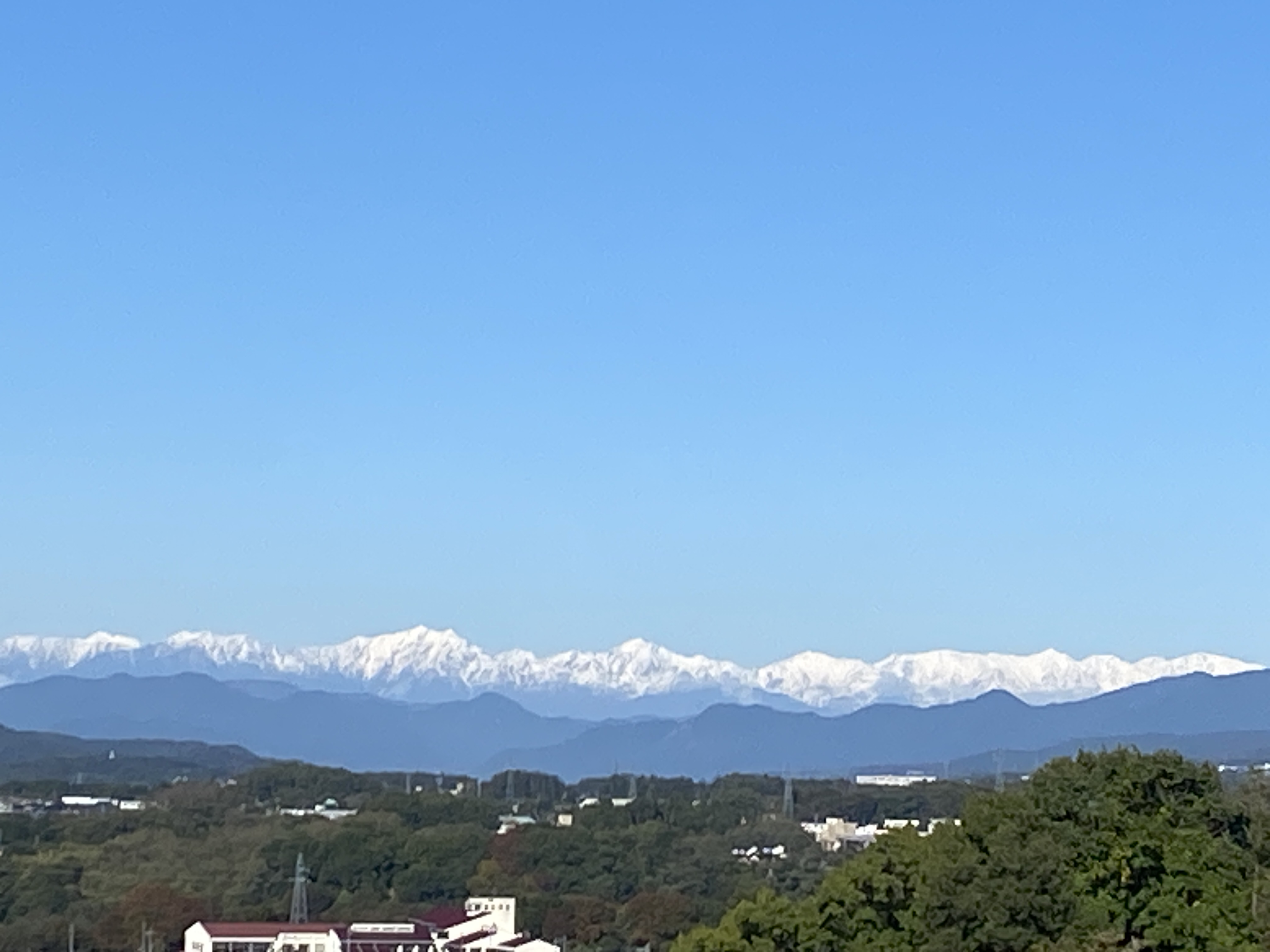
This area I went to is characterized by a viewpoint on a small hill which faces Mt. Asama, the Takamine Kogen and Yunomaru Kogen across the valley which the Chikumagawa meanders through.  

One of the first things I did when we moved here was to run to that viewpoint from home and back--about 10km.

Since then, I've hiked there about 20 times because it's so convenient.  Since I go there so often, I don't usually blog about it but today it was just too pretty not to share some pictures.

If any of you have been through Saku, you may know the Michi no Eki (rest stop) called Healthy Terrace Sakuminami.  Mt. Kokuzo is right behind there.  You could hike up it in about 30 minutes from the Healthy Terrace.
I usually start at the Tafuku Temple.

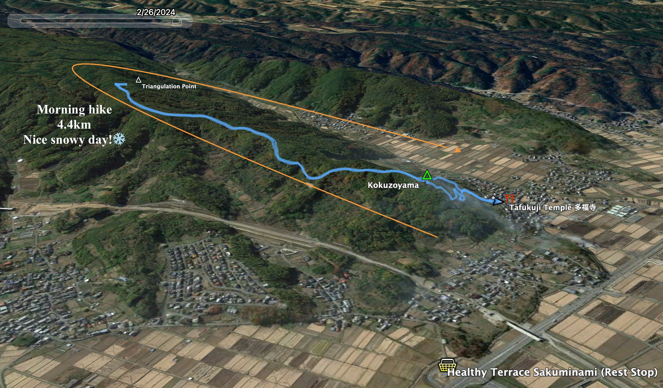
I don't stop at the viewpoint either.  I typically go as far as a certain triangulation point further up the trail.


I was on Kengamine a week or so ago.


I was on Yunomaru two days before.


That's all.

Caveman out.


Trail run (?). Hirao Fuji. Saku City. Nice fallviews.


This morning I took a run up Mt. Hirao.  Hirao is one of my go-to places if I have time for a run before the sun sets after work.  It's located in the northeast of Saku City, just above the highway.  It's visible from most of the city--and it has great views.


Location:  Mt. Fuji Hirao/Hirao Castle Ruins

Starting and stopping point:  Sakudaira IC Parking Lot

Peaks bagged: Hirao

(First-time) peaks #xx (Not my first time here)

Getting there/getting around:  I drove.  There is plenty of parking.  The parking lots at the onsen don't open until 8 but I was able to park at the highway parking lot.

Map:  Yama to Kogen Chizu #21 西上州 妙義山・荒船山

Weather Information: Mt. Arafune's weather (not too far away)

Total Time:  2:09 Break time: :00  Distance:  12.1km

Elevation:  Lowest:  788 m Highest: 1,155 m Total Ascent:  727 m Total Descent: 727 m

Technical considerations/difficulty:  

There are a variety of trails that I used on this run.  There are hiking trails, ski trails and some forestry roads.  

I lost a lot of time by trying to run under one particular ski lift.  There are two lifts I ran under.  The one on the lower half of the mountain is easy to proceed up.  The entrance to the hiking trail is near the top of that lift.  Until today, I'd always left the ski trail there and entered the hiking trail.  This morning, I tried to continue toward the top following under the upper ski lift.  This turned into a slow exercise in bushwhacking up a very steep, prickly, wet, slippery slope.  I lost a lot of time there but got to burn a few calories--and collect a few scrapes and scratches to the delight of my inner-9-year-old. 

Most of the trails and some of the roads up here aren't on maps.  It's quite easy to get twisted around.  I would stick to the marked trails if you don't have some kind of gps device.

Facilities:  Nothing on the trail.

Thoughts/observations/recommendations:  Do it if you can.


Today's listening:  Bible in a Year


Winter's coming.  Brace yourself.


Yatsugatake


Alps


Mt. Asama


This escalator from the onsen down to the Sakudaira Toll booth and parking lot really sticks out.  You can see it for miles around.


That's all for now.
Subscribe.  Tell your friends, etc. 
Or not.


Caveman out.


The last mountain for a while. 😭 Mt. Arakuru trail run before the typhoon

 Location:  


Starting and stopping point:  Myosenji

Peaks bagged: Akaru (閼伽流山)

(First time climbed) peaks None today

Getting there/getting around:  There is parking at the Myosenji Shrine

Map: I don't think there is a paper hiking map covering this.  I just used my hiking app--YAMAP.

Weather Information: 

Total Time:  :53 Break time: :00  Distance: 3.6k 

Elevation:  Lowest: 755m  Highest:  1,028m Total Ascent: 320m  Total Descent: 320m

Technical considerations/difficulty:  There are several steep spots with ropes.  The lookout spot near the peak of Akaru has a large dropoff.  I really wouldn't want to fall off there.  Much of this trail is runnable, but large portions aren't.  

Facilities:  Nothing

Thoughts/observations/recommendations:  Today is the first day of the obon holiday.  It is also the day that a typhoon is arriving.  I had big hopes for big mountains this week but . . .  I decided to at least get in a run before the forced hibernation of the coming few days.  This is a fun little area.  There are some really cool boulders around this temple's precincts.


Today's listening: Nothing


😭😭😭😭😭😭😭That's all for today.  Time to start hibernating.
Caveman out.