It's only the 23rd, but I find myself at the blog and, since it's so close to Christmas, I think it warrants a yule greeting. Especially since I saw Santa today!
This being Saku, he didn't come by sleigh. 🛷 Saku has its own mode or aerial transportation. (On second thought, perhaps the reindeer went on strike and that's why there's no sleigh. Astute readers of this blog and my eating habits will be aware that any type of deer might be skittish about coming too close to this area. 🦌🥩)
I wasn't planning on going into the woods this morning but felt the draw when I stepped out the door to do an errand I encountered a winter wonderland.
Elevation:Lowest: 1,337m Highest: 1,756.7m Total Ascent: 700m Total Descent: 700m
Technical considerations/difficulty:
Facilities: Nothing on the trail. The trailhead does have a sign which sports a QR code to allow you to post a hiking plan electronically. That's convenient.
Thoughts/observations/recommendations: What a nice mountain Asama Kakushi is. It's obvious why it is on the list of Japan's 200 Famous Mountains. The 360-degree view at the top is superb. I could even pick out Mt. Fuji 119 km away.
It's fairly steep, but there are no ropes or chains. There is a lot of bamboo grass which seems to offer some difficulty to hikers when it isn't trimmed. Today, the path was clear. All but the top of Asama Kakushi is below the treeline.
It is not a full-day hike but could be nicely paired with a trip to the nearby Asama Falls or the Onioshidashi Volcano Park to make a day of it.
First of all, please accept my apologies. Christmas deliveries are canceled this year because I ate Rudolph for lunch.
Ho ho ho
Wow. That was yummy.
No, it did not taste like chicken.
(Actually, it was steaklike and surprisingly tender. It was a great sandwich 🥩 meat.)
A few days ago I went for a run up one of my local favorites, Mt. Hirao Fuji. If you are familiar with this area, you might know the Sakudaira Interchange on the highway. Hirao Fuji is the little hilltop above the ski area and onsen by the interchange. That run was a bit of an adventure in itself because I found a new trail. I go there a lot, though, so didn't bother blogging about it. I did get this picture of where I was to be headed the next day, though.
I parked at Nidoage Pass (二度上峠) right on the line between Kitakaruizawa, Nagano and Takasaki, Gunma. My first stop was a steep, short hike up to Mt. Komagami (駒髪) from there. The view from the top would be spectacular but for the fact that it's obscured by trees.
Just starting out
The top
This was taken from the parking lot.
After that little excursion, a short walk down the street brought me to the trailhead to Mt. Asama Kakushi.
This sign has a QR code to put in a hiking plan.
The top
Looking at Mt. Asama
I don't typically take long breaks but the viewpoint here was so good that I stayed up here taking pictures for about a half hour. It was really fun to look around all points of the compass and to pick out places I've been. That's one of the things I like most about hiking.
Yatsugatake is in the middle of the frame.
The orange figures depict mountains on the 100 Famous Mountain list. The red markers are peaks over 3,000 meters.
?? Do you see what I see?
That was Mt. Fuji a bit to the right of center. I was so surprised to see it since the clouds were blocking mountains even in the immediate vicinity.
In case you're interested . . .
to the south
to the southwest
to the east southeast
I bumped into this guy on my way up to Mt. Iwabuchi.
That is a kamoshika. Kamoshika sounds like the words for duck and deer but a kamoshika is neither a duck nor a deer. It's a serow. It's more like a goat-antelope. They are supposed to be very fast--there's even a motorcycle called serow--but every time I've come across them, they've been very chill. They don't seem to be bothered by humans at all. I was standing in one spot making some adjustments to my pack for about 5 minutes before I realized this guy's (gal's--what do I know, I'm not a biologist) presence. He/she must have been watching me the whole time. Thank God it wasn't a bear.
This is the top of Mt. Iwabuchi. It's probably the last peak for me of 2023. It's been a great year in the mountains.
Asama from the parking lot
Well, that's all (probably) for 2023
I hope you and yours have a Merry Christmas and
a great 2024
Make sure you subscribe so you get the first post of 2024 before anyone else!
By the way, this parking lot is by the 長者の森 Campground. ("Choja no mori" Campground) I was curious about the name of this place. The "no mori" part just means "forest." That's easy to understand. The "choja" part is the puzzling part of the name. By itself, "cho" means long, and by itself, "ja" means person. It's the same "ja" as in "ninja."
Together, though, what does the compound word mean? Consulting my favorite Japanese-English dictionary was illuminating.
There are four possible translations of choja. While the first three that appear in the dictionary are auspicious, the fourth is downright scandalous. 😆 👢👯
(n) (1) (ちょうじゃ only) millionaire; (n) (2) one's superior; one's elder; one's senior; (n) (3) (arch) virtuous and gentle person; (n) (4) (ちょうじゃ only) (arch) female owner of a whorehouse in a post town
"Millionaire" to "madame", OK. I think the progression is usually in the other direction.
By the way, if Mrs. Caveman asks, let's just tell her choja means millionaire and leave it at that, ok? Thanks.
Peaks bagged: 前衛峰 (Zeneimine) ~~ 御座 (Ogura) ~~ 前御座 (Maeogura)
(First-time) peaks #842, 843 and 844
Getting there/getting around: I drove. There is a municipal bus from Koumi Station to Sanzunki (三寸木バス停) Bus Stop for 100 yen. From there, it is a 45-minute walk to a trailhead. That isn't the same trail I used, but it's in the general vicinity. n.b. the same place that contained that bus information recommended staying overnight if using public transportation because of the time needed.
Elevation:Lowest: 1,240m Highest: 2,112m Total Ascent: 1,235m Total Descent: 1,235m
Technical considerations/difficulty: It's steep and there are some places with chains. Most of it is below the treeline.
Facilities: The Chojanomori Campground is seasonal. I was the only person there. I assume that during the camping season public restrooms are available. On the mountain, the only facilities I encountered were the refuge hut just off the peak. There is no restroom there. There is no water on the trail.
Thoughts/observations/recommendations: Mt. Ogura (御座山) was the target for this hike. A few months back I spied it from Yatsugatake and thought it looked cool. It is cool. Mt. Ogura is one of Japan's 200 Famous Mountains. The mountain's name is, like many Japanese mountain names, difficult to read and to understand. Most Japanese people won't know how to read this unless they look it up in some mountain glossary. The name is similar to the word used for the emperor's throne and is said to have been named as a place where gods would come and sit.
Today's listening:
Bible in a Year Hard to believe that this audio trip through the bible will wrap up in a few weeks. I've read the bible through a few times. Listening to it was a bit different. And obviously less labor-intensive!
I know how Julia Roberts felt when Richard Gere took her shopping on Rodeo Drive. I had two new pairs of boots arrive yesterday!
(The Columbias on the left are my go-to 3-season boots. I go through a pair of these each year. I get about 400 km (250 miles) out of them and they don't cost much more than $100. The Salomons are a new addition. They are serious cold-weather boots.)
Yesterday, when I laced them up, I was new boot goofing like Lt. Jim Dangle.
On to the hike. This is at the beginning, at the Choja no Mori trailhead.
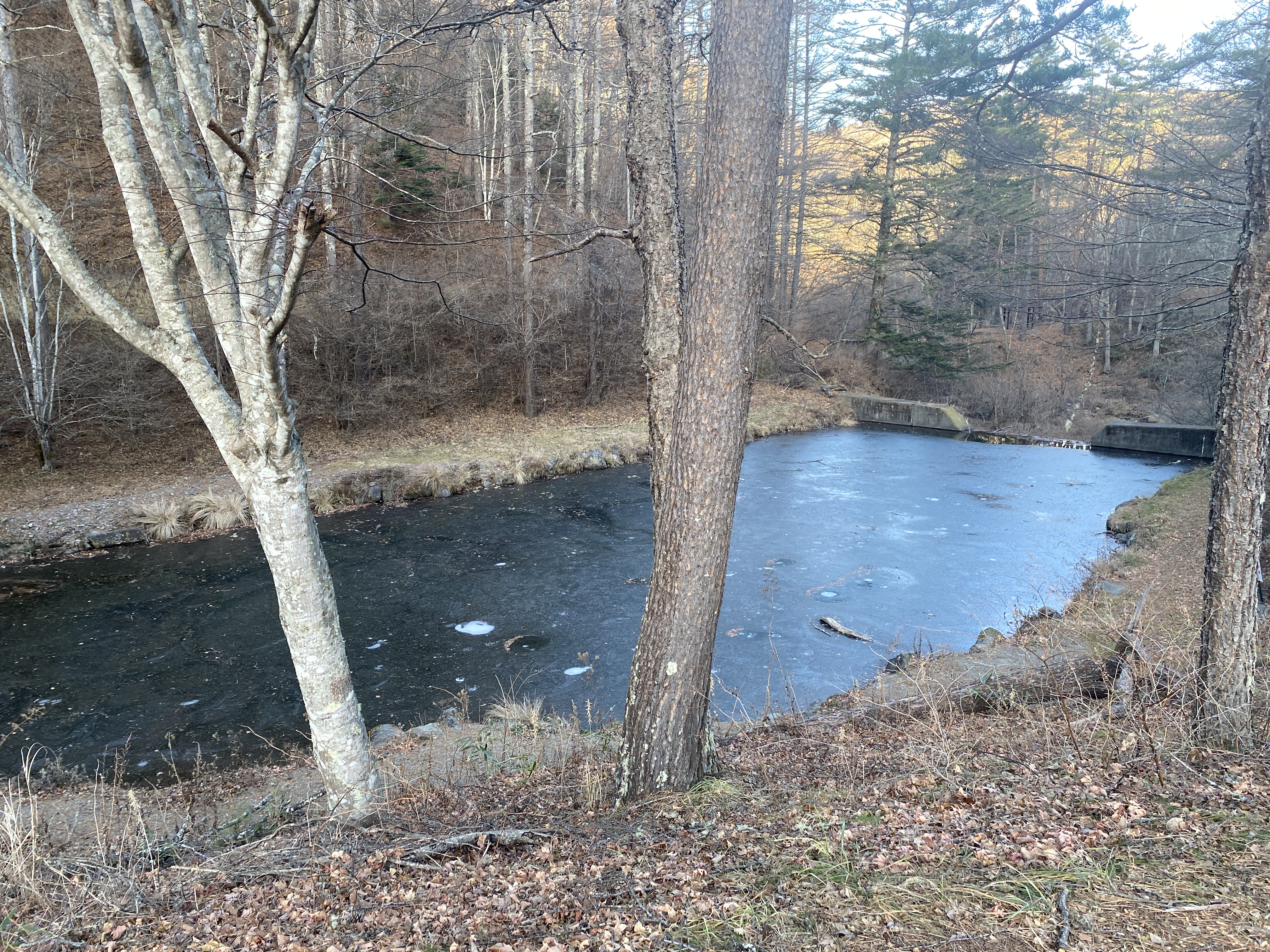
Even though it was unseasonably warm, the ponds in the area had some ice. I saw one pond with ice thick enough to walk on.
Nice day!
The Ogura Refuge Hut
The silver thing seems to be rescue apparatus. That's good to know.
Mt. Kitadake, near the middle of the picture, is Japan's second-highest mountain and is in the Southern Alps.
Mts. Gongen and Akadake, on the right, are at the southern end of the Yatsugatake range.
This is looking south from the peak of Ogura. Those are some of my favorite mountains.
(They're all my favorites, truth be told.)
Looking west toward the Northern Alps
Looking north.
Looking east
At the top of Ogura, I was enjoying my new boots when I spotted this group and their unusual footwear. I thought it strange that they removed their shoes for a break. Not so. They hike without boots!
It turns out they are really into not wearing shoes and have a business spreading their message. Their business touches on ecotourism, sustainability, barefoot walking/running, etc. They do much more than I could hope to explain in this space. Their website is here. (Japanese)