Missed it by that much. The last sunset of the caveman's year in Yamanashi.


Missed it by that much.

Hello cave critters.  Welcome to the last post of the year.  

I have been casting about for new mountains to climb and it's getting mildly difficult to find mountains I haven't climbed already that are within commuting distance.  I was spoiled when I got bitten by the mountain bug.  I live close enough to Okutama that for a few years I could simply take my bicycle and find a new mountain.  Now I need to go farther away.  

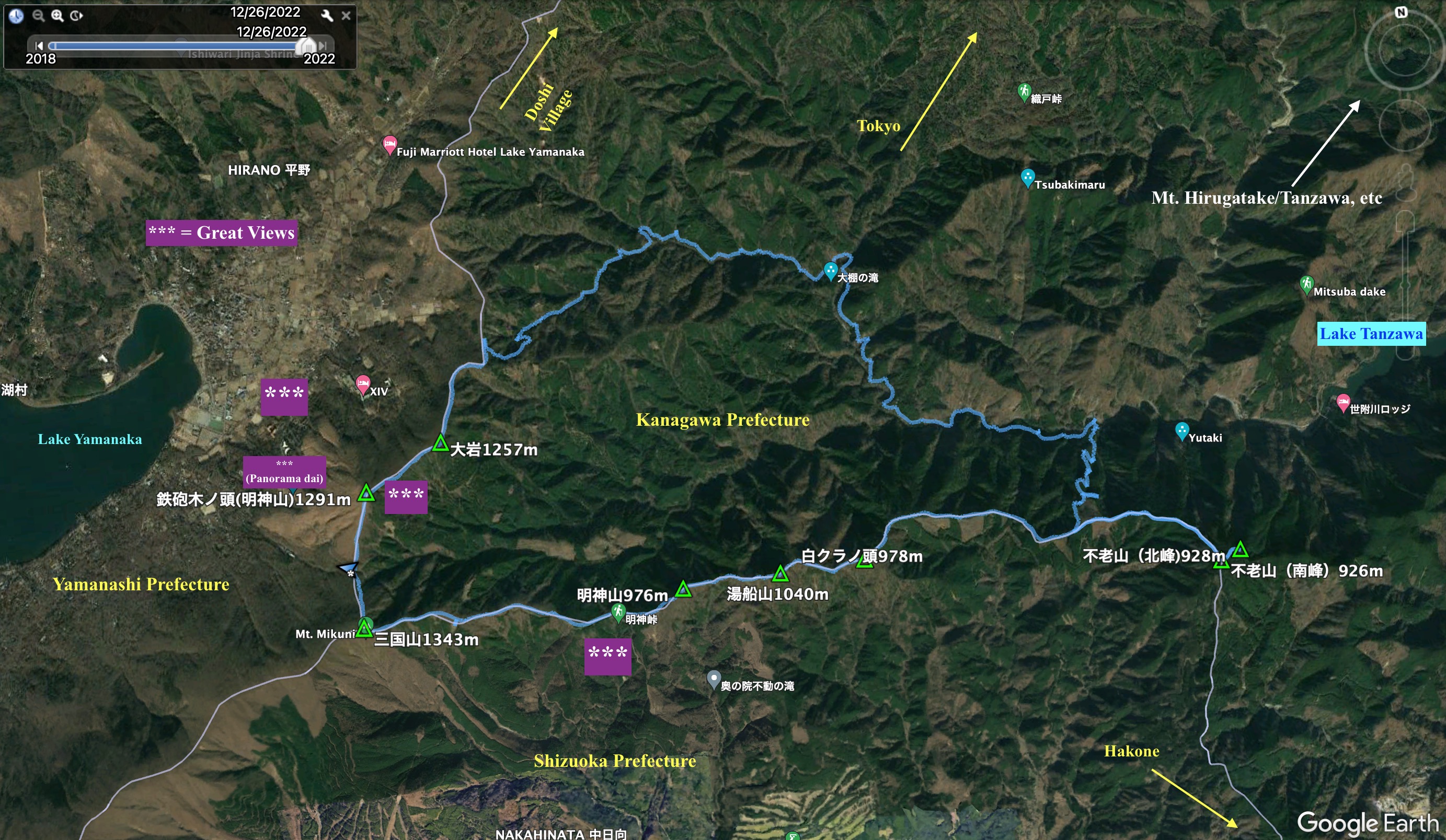
Yesterday, I chose a spot between Lake Yamanaka in Yamanashi Prefecture and Lake Tanzawa in Kanagawa Prefecture.  I've hiked all around Yamanaka and have hiked quite a bit in the Tanzawa area, but never in this corner of Kanagawa.  Let me get the details out of the way so I can share some pictures with you.

Location:  Yamanashi/Shizuoka/Kanagawa

Starting and stopping point:  Mikuni Pass 三国峠

Mountains climbed: Mts Mikuni~Moujin~Yubune~Shirokuranoto~Furo (North and South Peaks)~Oiwa~Teppokinoto

Getting there/getting around:  There is a parking lot at the Mikuni Pass.  There are buses that stop close by the lake.  Mt. Mikuni and Mt. Teppokinoto are convenient to buses.  There is also a bus stop at the Myoujin Pass.

Map:  Yama to Kogen Chizu Tanzawa #29 山と高原地図・29・丹沢

Weather Information:  Mt. Furo Weather

Time:  7 hours 45 minutes plus 45 minutes break

Distance:  26.9km/16.7 miles

Elevation:  Lowest: 395 meters Highest: 1,320 meters Total Ascent: 1,891 meters Total Descent: 1,891 meters

Technical considerations/difficulty:  This was not a very technically challenging hike, although it was long.  There were only two spots I recall where ropes were in place.  For the most part it was not too steep.  One portion where the trail is not really well-marked and you need to use common sense to pick your way is between Yozuku Pass (世附峠) and the Yozuku River below.  To descend from there to the river, you need to find your way down a spider's web of forestry roads.  They are all in disrepair.  Some of them dead end.  Portions of them have disappeared in landslides and you must decide whether to detour or turn back.  That part of the hike took me a lot longer than I estimated it would.  After that, the final several miles of the hike are along a closed, lonely forestry road.  That wasn't in very bad shape, though.  I was able to make up some time. 

Facilities:  Nothing commercial.  My (2019) map shows restrooms at the Myojin Pass (明神峠) and the Yozuku Pass (世附峠) but I can't recall seeing them when I was there.  I seem to remember Yozuku Pass as being especially barren.  Maybe there used to be a restroom.

Just hold it.  Patience is a virtue.

Thoughts/observations/recommendations: One of the nice things about this hike was that there was nobody there.  Well, almost nobody.  I did see two guys eating lunch at the top of Mt. Furo.  And I happened upon one fisherman by the river who happened to be relieving himself just as I was coming around the corner.  That was funny.  He really didn't expect anyone to show up when he decided to do his business al fresco.  Being Japanese, he still tried to be polite and do the greeting/small-talk thing with me.  

Without zipping up.  😂

I'm really glad Japanese people don't shake hands.  

This was probably my last trek for 2022.  I have thoroughly enjoyed the mountains this year.  I'm glad to have ended the year on a day of good weather and am looking forward to getting out again to start 2023 right off the bat.  I'm not sure what my plan is for the next year.  I've been going out at least once a week for the past 2 (or 3?) years.  Part of me thinks it would be sane to slow down.  The other part of me says "Why?"  I always enjoy the mountains and I really like to think about them after I come home.  

I'll tell you a secret, dear reader.  I would be keeping this blog even if nobody read it.  It's more for me than for anyone else.  I just want to remember what I've done.  If I can make some happy by showing them some beautiful pictures or if I can give someone ideas about hiking in Japan, that's great.  I don't expect it, though.

Anyways . . .


Here are some pictures:

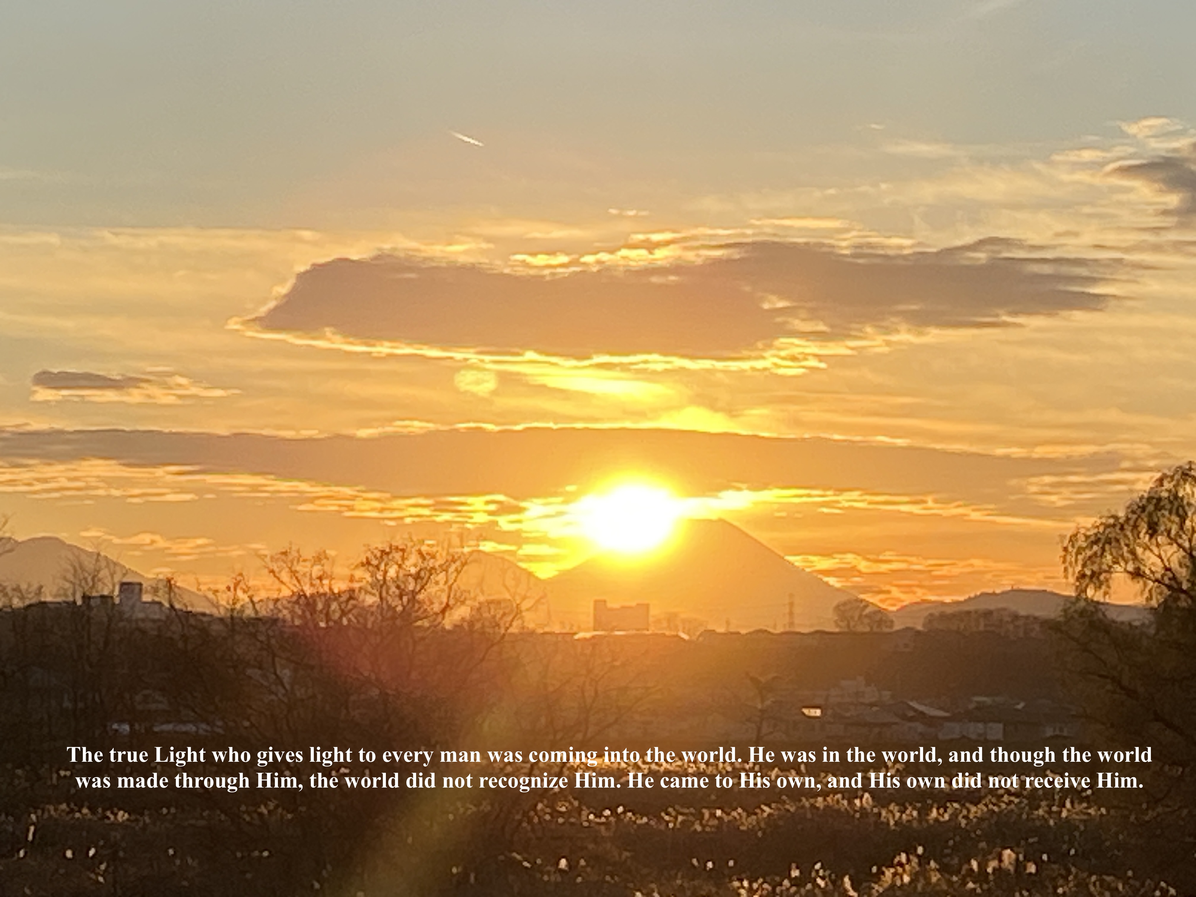
The first Google Earth screenshot shows a map oriented to the west.  This gives a sense of where I was in relation to Mt. Fuji and Lake Yamanaka.  The best views I had of Fuji were at the beginning and the end of the day since I started and ended nearer to Fuji.  

If you notice, there are little green triangles dotting the screenshot.  Those are places I've been before.  I don't know why, but Google Earth has seemed to lose about half of them.  I have such a bad memory that I sometimes forget the places I have climbed without seeing some kind of documentation.

You can see Mt. Mikuni at the top left of my footprints.  From that point, there is a grey line tracing a ridge up to the top of Fuji.  That is the prefectural boundary between Yamanashi to the north and Shizuoka to the south.  A trail runs along the border.  I hiked that trail as far as the Misaka Pass on Route 138 earlier this year.  A little further along from there that trail joins the Subashiri Trail to the top of Fuji.


Oriented to the north


I think I took this picture from the street at the Yamanakako Panorama Dai on Route 730. 

Those mountains on the northeast side of Lake Yamanaka have great views.


After 2 hours on the bike, I was glad to get moving.  It was a few degrees below freezing for the first few hours.


Looking back over my shoulder...


More on Kintaro here :Kintaro

The next picture is of yesterday's furthest point; Mt. Furo.  This mountain's name translates to something like eternally young.  

I had a decision to make here.  My planned route would take me down off this ridge into a winding river valley which would lead me more-or-less in a circle back to my departure point.  The return route was much longer because it was less direct.  BUT, it was a road, not a trail and I assumed I would make better time on that than climbing.  I wanted to get back to the area I started from by sunset at 4:38.  Specifically, I wanted to get to Mt. Tepponokinoto* for sunset.  I climbed that earlier this year but missed out on what promised to be a good view by bad weather.  I hoped to make up for that by catching the sun going down.
*Tepponokinoto means "Gun~Tree~Head."

I knew that I would make it if I just returned the way I came, but I would actually be too early.  Also, I like to cover as much territory as possible and avoid retracing my steps as much as possible.  I knew I would be cutting it close for time because I had lost a half hour on the road in the morning.  (I made a few bathroom breaks just to warm up!)

In the end, I decided to go with my original plan.  Stick around to find out what happened.


Soon after coming off of Mt. Furo, just passed Yuzuku Pass, I descended on a trail that was shown as a dotted line on one of my maps.  It doesn't show up on my other maps.  It turned out to be a network of forestry roads.  Some parts of it were in great repair.  Some parts were washed out.  No one of the roads really matched the map.  Getting to the bottom of the valley took a long time because it necessitated a lot of switchbacks.


This spot is where I first saw some deer.  There were signs of them--scat, barking--all day, but from this point until almost the end of the day I kept running into them.  They don't show up in this picture, though.  I am showing the picture just to show the condition of the road.

In some places the road was great.


After about 40 minutes, I got to the bottom and the Yuzuku River.  


At the river, I discovered that the road, Route 729, that I was to start walking on was more of a forestry road than a tertiary road, like I thought it would be.  It was completely blocked off to cars and there wasn't sign of a soul in sight.  I was a little worried what this might mean time (and safety)-wise.


I encountered some more time wasters on the way.  It seemed like I could not go 50 feet without coming across deer.  I love seeing deer and I can't help taking their picture.  It began to concern me as the clock was ticking.

Look at this if you want video of some of the deer I saw.


The Yuzuku River


More deer
I eventually got to the point where I stopped taking their pictures.
I was watching my time and my pace and knew that I would be really cutting it close to try to make the sunset.  They are cute, though.  Especially at this time of year.  The adults have now big white bushy tails which make their hoppy way of running funny.


After I stopped taking pictures of the deer, I made better time.  After about 7 km on the forestry road, I turned into the woods again for the push up to my objective.  Time was tight.  I had only 1 hour and 18 minutes and 4.6 km (3.1 miles) to go.  The problem wasn't just the distance I had to go horizontally, it's that I also had to ascend 520 meters.  How long does it take to walk up 5 soccer fields?  I thought I might make it if I hustled.  I ran where I could. 


About 50 feet to the top . . .


Close enough.  I'm glad I got this much of a view.  


Finally at the top.
🕺😎🌅


I got to my scooter at 5:02.  It took me 20 minutes before I could hop on and go.  I needed to put on a few more layers and the temperature had dropped so much I had to stop and warm my fingers up for each button I needed to button and each zipper I needed to zip.


Well cave creatures, that sunset lowers the curtain on my cave for the year.

I hope that 2022 was good for you and that 2023 will be even better.

Don't forget to subscribe so you can be updated.  Leave a comment.

Come back next year.


Diamond Fuji and the Light of the World

Mt. Fuji is one of the most awesome sights I know.  I see it every day for most of the year and it still commands my attention every time.

At this time of year, if you catch it at just the right time and place, you can capture a diamond effect as the sun sets or rises behind it.  For Tokyo, we can see this phenomenon at sunset in the 3rd week of December.  One of the most popular spots for this is Mt. Takao.

I took these pictures on December 18, 19 and 20 last week from the Tama River in Tachikawa.  I didn't really catch the diamond effect.  I wasn't in the best place or even using a proper camera, but I still like the pictures and hope you do, too.

As it's Christmas Eve here, I am conscious of what a gift Mt. Fuji is.  More than that, I'm thinking of what a truly awesome giver could have given us the gift of Mt. Fuji (and the gifts of the sun and the stars and hair and skin and opposable thumbs . . .)  

And since Christmas Eve is the beginning in one way of the Christmas story, I thought it might be appropriate to reflect on the beginning.

And God said, “Let there be light,” and there was light.  Genesis 1:3