

(黄金の湯 Kogane no Yu)
S'up, Cavedwellers?
The Caveman here. I got the chance to climb Mt. Myoko (妙高山) in Niigata today. It was great!
Location:
Starting and stopping point:
Peaks bagged:
Mt. Myoko Minami Mine and Mt. Myoko Kita Mine
(First-time) peaks
#888 and 889
100 Famous mountain peaks
#31
Getting there/getting around:
I drove.
You can get to the trailhead from Tokyo Station in about 3.5 hours. Take the Hokuriku Shinkansen to Nagano. Change to the Shinano Tetsudo Kita-Shinano Line on platform 2 and go 7 stops (45 minutes) to Myokokogen Station. Then take the Myoko Haneuma Line 1 stop (9 minutes) to Sekiyama Station. Then take the Myoko Sanroku Line (妙高山麓線)of the Myoko City Bus 20 minutes to the Tsubame Onsen (燕温泉). (Just researching that makes me tired.) In 2024, that trip costs ¥9,930.
Map:
Weather Information:
Stats
Time
Total Time: 6:31 Break time: 1 hour Distance: 13.3km
Elevation
Lowest: 1,083 m Highest: 2,454 m Total Ascent: 1,550 m Total Descent: 1,506 m
Stuff to think about
Technical considerations/difficulty:
This is a steep climb. The trail is very sturdy and well-maintained but much of it is exposed and there are many areas where you must use chains to climb and there are several places where you must walk next to a sheer drop. Now, at the end of May, there are still many snowy parts that made for slow and slippery going. For much of the trail along the Jigokunodani (Hell Valley), your are walking on the snow cover over a stream. The snow has melted through in spots, and in some spots you can find the snow give way beneath your feet and plunging you into the water below. There is a fair amount of scrambling over boulders to be done, but really not that much. Care must be taken but I saw people of all ages, from elementary school kids to grandmothers, on the trail.
Facilities:
There is free parking for about 30 cars just below the Tsubame (Tsubame means Swallow) Onsen and there is a public restroom at the parking lot.
There is a box to drop off a hiking plan notification at the restroom. There is also a box there requesting donations for upkeep of the trails. They are asking for ¥500~¥1,000.
There are 5 or 6 hotels clustered together just below the trailhead. There are waterholes marked on the map. I would normally be a bit nervous about drinking from a stream in such a volcanic area, but they were on the map so I gave them a shot. I haven't keeled over yet.
There is a really cool outdoor bath (rotenburo) just before the trailhead. There's nobody manning it but there is a small hut to change in and there is a box for donations. That was great to make use of before going home.
Thoughts/observations/recommendations:
The weather is really warming up and the mountains here in my corner of Nagano have had the majority of their snow disappear so I forewent my crampons on this trip. It wasn't the end of the world, but I should have brought them. Niigata gets more snow than my part of Nagano. I found out today that Myoko gets 14 meters of snow annually. I'm thinking of leaving my crampons in my rucksack all year round. I was making snowballs on Mt. Makihata in July last year. I'm glad I had gloves. I had to climb hand over hand in the snow in places today.
If I were living in Tokyo or coming here from overseas, I think I would make this a two-day trip and incorporate Mt. Hiuchi--another of the 100 Famous Mountains--into the plan. This is far and expensive to get to from Tokyo.
I was tempted to do both of those mountains today because I got a very early start. I decided against it though because the snow conditions made for a bit slower going than if it were a late summer day.
One thing that recurred to me today is how often I meet people I really like in the mountains. Maybe it's the same among other people with common interests, but I find hikers to be ready and happy to chat with strangers to a degree I don't usually see in society. It's not just the atmosphere of being in nature because it's only the mountain enthusiasts who are like this. Meeting the typical day-tripper in the mountains doesn't usually result in any kind of interaction at all. I met and interacted with three or four groups of people today that reinforced my feelings on this.
Here are some maps and stuff.

Here's a silly video in case you're interested.
OK, let's look at some pictures.
I got this one from the road on the way.


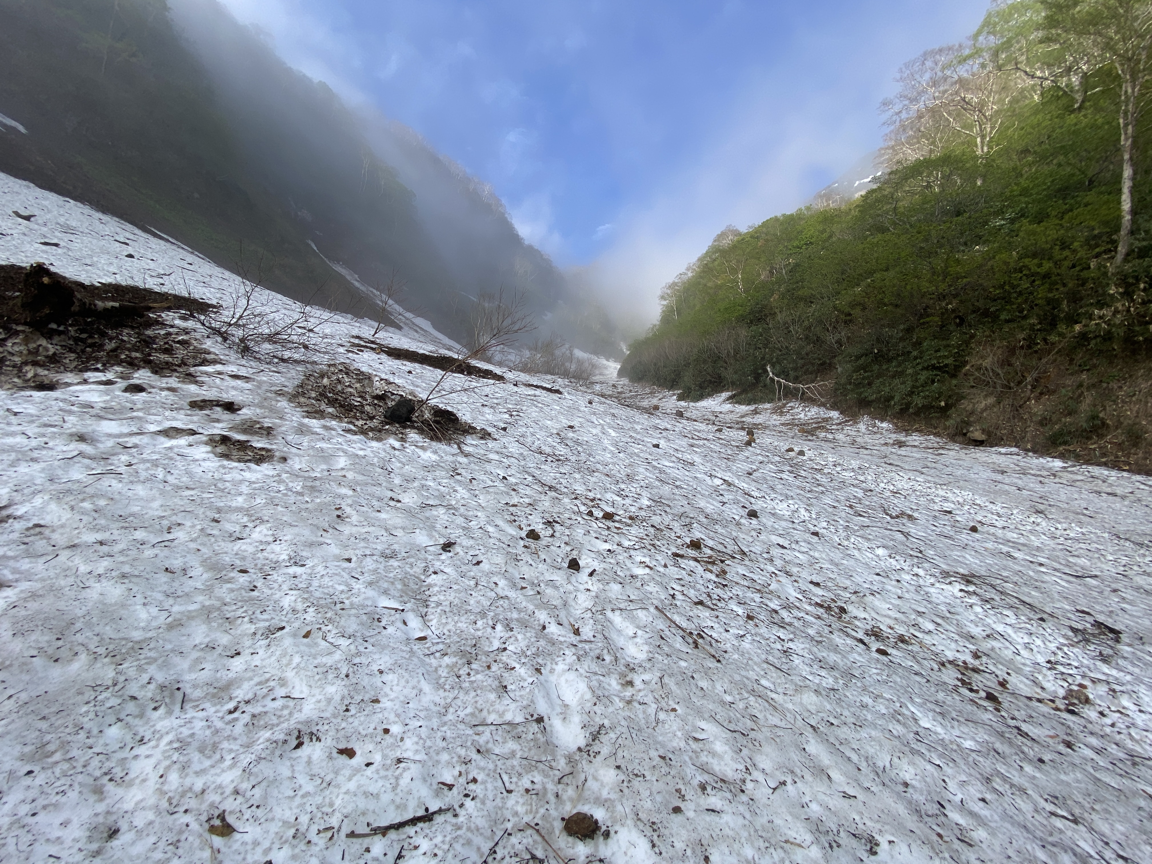
Hell Valley (Jigokudani)
The snow was quite slippery and the slope is steep for a few hundred meters along Jigokudani.
It was the most arduous and nerve-racking part of the hike. It was also a bit worrying to know that a stream is running beneath the snow and that the snow crust might cave in without warning.
The river . . .

The river is visible through these holes


That's one of the holes . . . but there wasn't any wind coming out.

Note where the picture was taken from; "Chinoike." That means blood pond. Shiver.

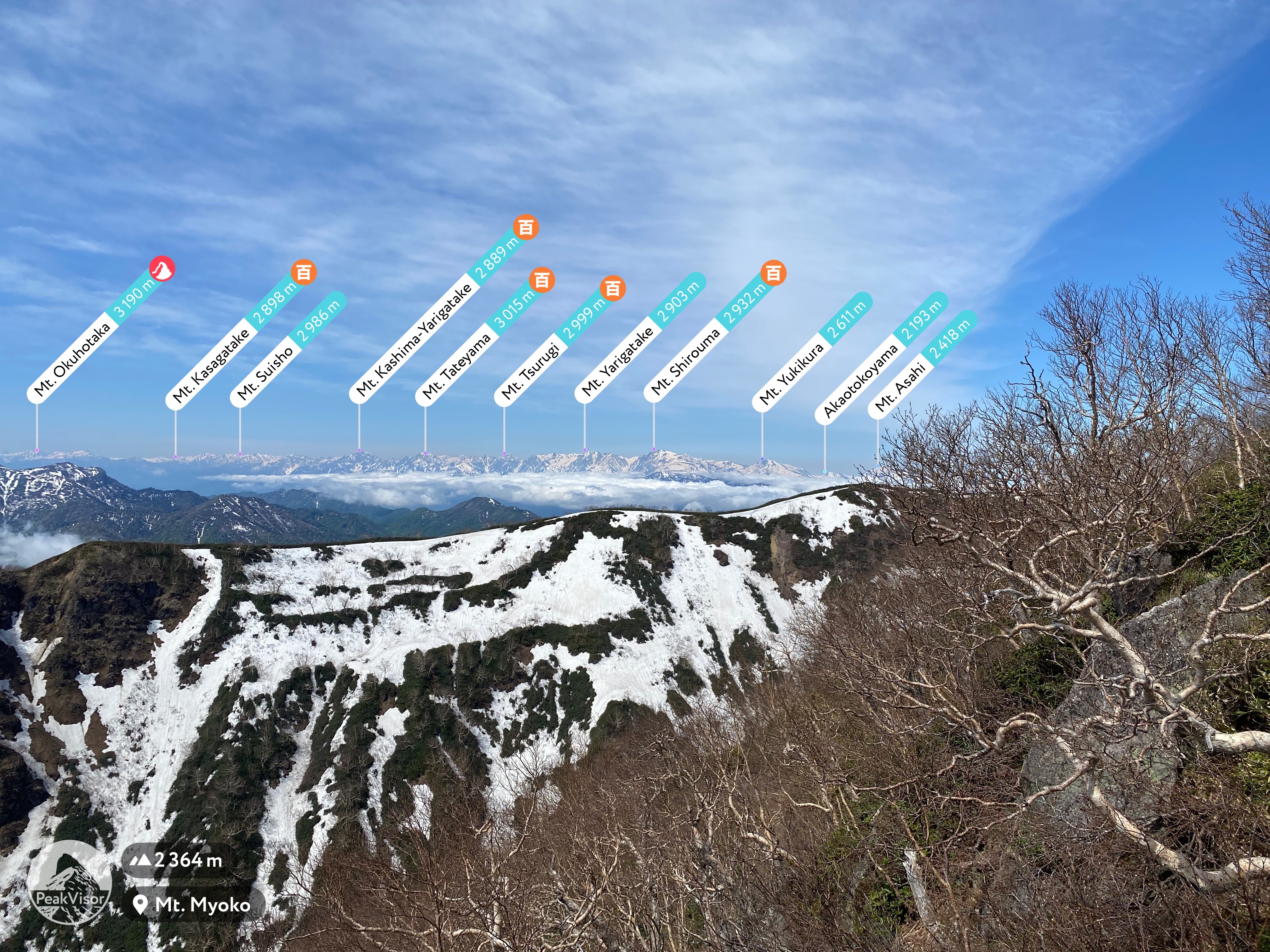
There were some blue skies when I was on top, but this was one of the few views I got of the mountain from below.


Time to head back down


Kogane no Yu"

Men to the left, women to the right. The women seem to have just a bit more privacy because of that screen.

Oh, yeah. That's the place to end this day! 👍 ♨️


