Sannose~Shogen Pass~Ryubamiyama~Ootsunegi~Hiryuyama March 19, 2021

Enjoying bagging as many peaks as I can while spring vacation lasts.  


Yesterday I went out to the area around the Ichinose River again and crossed off two peaks I had to give up on last month.  My plan then was thwarted by the weather.  First, when I got into the mountains on my bike, I  had to dismount my motorcycle about three miles before the trailhead because of ice on the roads.  Then the amount of snow and ice on the trails inverted the fun to danger ratio so much that I opted to turn back rather than become another kind of statistic myself.  


Here in the Japanese outdoors community I often hear of the "courage to give up."  I don't think of it as courage.  Maybe prudence.  


Or as just not being stupid.


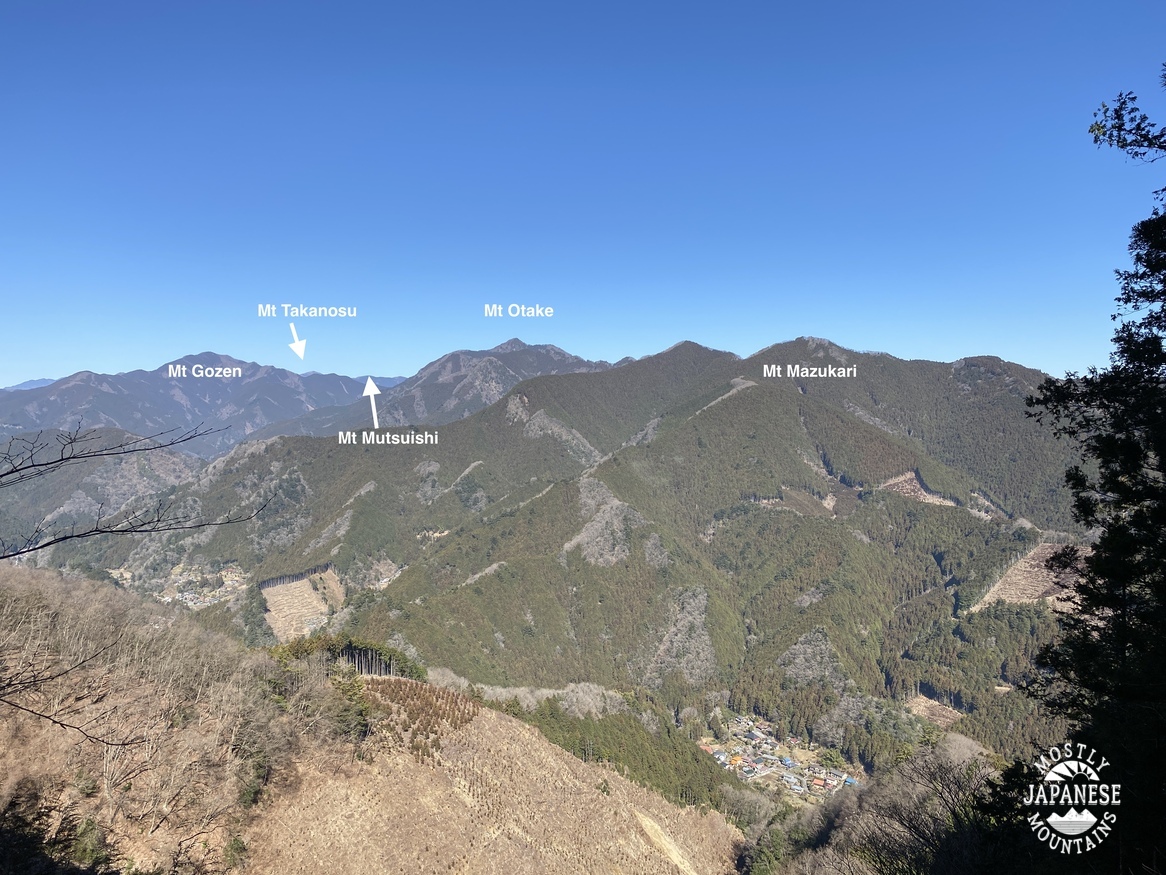
My first stop yesterday was at an overlook which gave me a profile of the day's mountains.  (I've done all the ones on the left already.)


大栗展望台 Koshu Yamanashi Okuritenbo
Here is a link to a map showing where this sign is:   sign


Shougen Pass 将監峠 Ryubiyama ootsunegiyama Mt. Hiryu 飛竜山


Starting out along a stream.

I love water in the mountains!


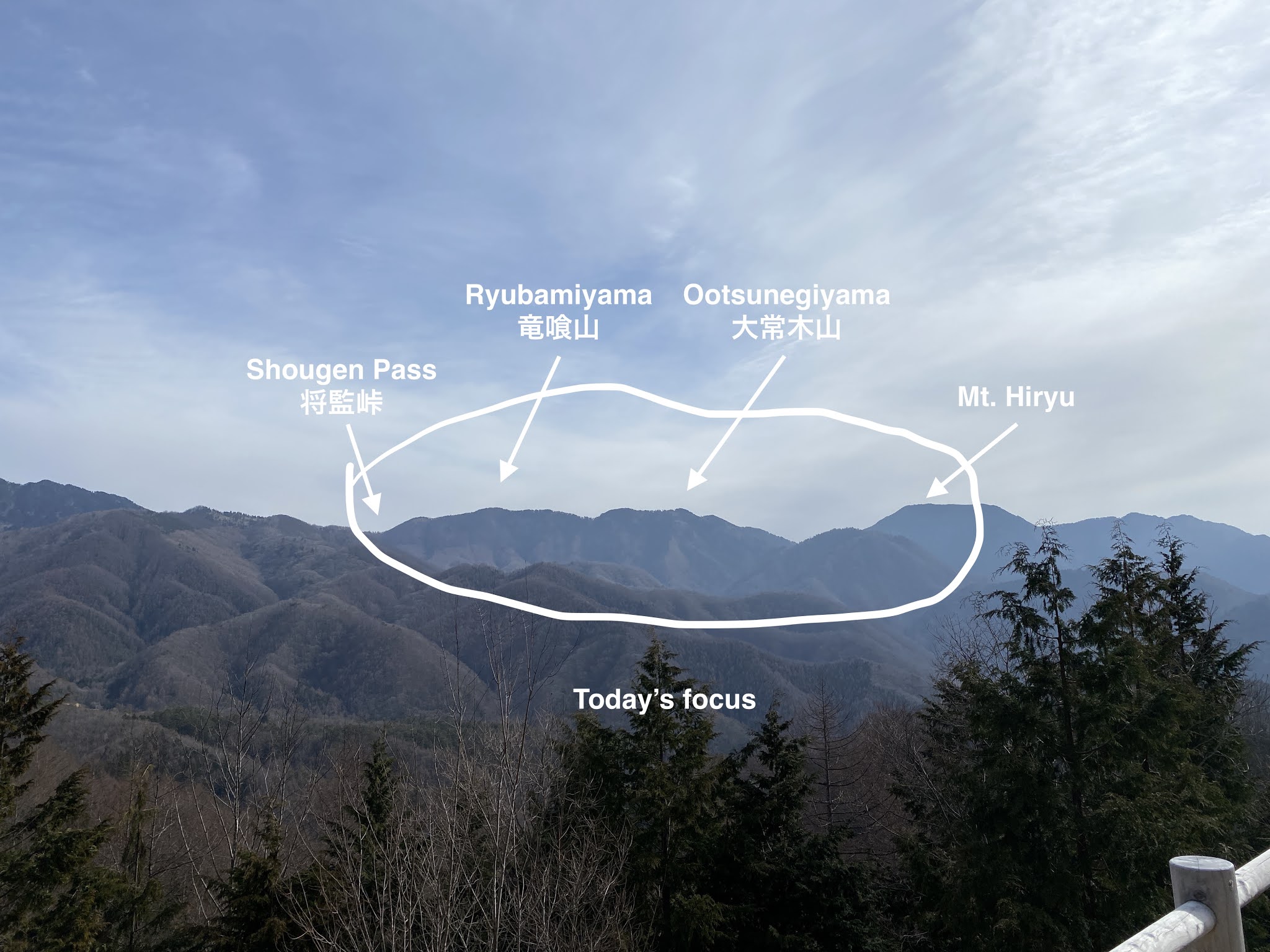
That blue thing down below is the Shogen Pass Hut.  There is a water source year-round.  There are toilets, lodging, and dining facilities in season.  It's open from April to November.  Stay there sometime and report back to me.  https://yama-goya.jp/kanto-lodge/syogenkoya.html


The two peaks I wanted to hit today are not on a very definite trail.  You just have to get up to the top of the ridge and follow it without falling off.  It's a bit more rugged and slow-moving than "hiking."  Sometimes vertigo-inducing.


Looking north from Mt Ootsunegi.  I've always liked that lone-tree against nature kind of picture.
大常木山 Mt. Otsunegi


The trail conditions still made for slow-going yesterday.  Despite very carefully watching each and every step, I still slipped a few times yesterday.  


I'm convinced that if I ever get really in trouble in the mountains it won't be from anything exciting like an avalanche or bear attack but from slipping in a mud puddle or maybe from being startled by a frog.


Lunch at 禿岩 (Hage Iwa, "Bald Boulder").  It's a nice viewpoint just below the trail junction under Mt Hiryu.
禿岩 hageiwa


On the final bit.

More soon I hope!

Can I get me a hunting license here?

 OK, I didn't really need a license because I didn't do any hunting in the conventional sense of the word.  I did do some trophy hunting today though.


This guy


Yamanashi deer skull 鹿の頭

Astute readers of this blog (which is probably my wife and no one else) will recall that I came across a deer carcass the other day.  It had been dead about three weeks and was nearly picked clean.  I wanted the antlers but couldn't detach them as the only tool I had with me was a jackknife.

I went back today with a tool worthy of the challenge.  I brought my Japanese-made titanium-ceramic knife with a serrated blade.  It really is a glorious instrument.  

It took about 20 minutes to cut the antlers off and I was a little worried my glorious Japanese-made titanium-ceramic knife with a serrated blade might not actually be up to the task.  It was much more difficult than I thought it would be and the knife is now trashed.  It may sound morbid, but it made me reflect a bit on the amputation of human limbs.  I'll bet the doctors in the US Civil War had massive forearms.

Here is the result of my labors:

Deer antlers 鹿の角

Now all I have to do is figure out how to boil these suckers clean.


If all this gore and such is grossing you out, perhaps you'd rather check out some live deer that I saw today.  These were within sight of the Kasatori Hut.


Since I was already nearby, I popped up to the top of Mt. Kasatori for the second time in as many weeks.  I really like this mountain.  You should check it out.  There is a reason that it is one of Yamanashi Prefecture's 100 Famous Mountains.  There was still a fair amount of snow on top.  It made me almost wish I hadn't left my crampons at home this am.

笠取の山頂 Top of Mt. Kasatori


Finally, I think I probably posted a picture of this before but it's worth another mention.  This little marker denotes the point of origin for 3 rivers.  Depending on which side of the marker a raindrop falls on, it may drain into Suruga Bay via the Fuji River, into Tokyo Bay by Haneda Airport via the Tama River or into Tokyo Bay via the Arakawa River.

I think that is cool.

小さな分水嶺 Origin of three rivers


Bike riding around Sayama and Tama Lakes

It was a gorgeous spring day in western Tokyo.  Rather than a hike, I grabbed my binos and headed for a bike ride to the trails around Sayama and Tama Lakes.  There are enough trails between and around those lakes to keep one occupied for a few hours.  Some of the views are really great, too.  


This map is one that I encountered inside the Rokudoyama Park.  Notice the orientation of North is down.  That drives me crazy.


One reason for this trip is that the Rokudoyama Park (六道山公園) in Mizuho is home to one of Kanto's 100 best views of Mt Fuji.  At least that's what this plaque claims.  I've been here many, many times but it seems like I never get to make this trek when the skies are clear.  So happy about the visibility today.


This is what the Rokudoyama Park Observatory looks like from below.

Rokudoyama Observatory

It was a crystal clear day so I was happy to catch these views from the top.

Fuji


I really like this sign on the wall of the observatory.  I have climbed all but maybe 5 of the mountains on it.  It's nice to be able to see them lined up in front of me.

瑞穂町展望サイン Mizuhocho Viewpoint

(You can also see downtown Tokyo and Skytree from this observatory.)


Another vantage point in the forest overlooks Yokota Air Base and I was able to see flight operations.  I live on the other side of Yokota under the flight path.  I don't often get to see takeoffs and landings.


From the Rokudoyama Park, I rode through the trails on the north side of the lakes and then turned right at the far end of Tama Lake and circled back before heading home.  This ride takes in parts of Mizuho, Tokorozawa, Higashi Yamato and Murayama.  On the way I skirted the Metlife (Seibu) Dome--where the Lions play--and Seibu Amusement Park.  One of the cool things about the path where it passes alongside the lakes is that there are more signs identifying what mountains you can see in the distance.

多摩湖から見える山 Lake Tama
I've climbed all but one of those.  So many good memories.  This sign is on Tama Lake.


Here is what the sign is expressing.
Lake Tama 多摩湖


I thought there might have been a game going on when I took this because I could hear the P.A. system.  I think it was just a test, though.  Opening day is a few weeks away.  

This dome makes a great landmark when looking down from the mountains.


Lake Sayama 狭山湖
This sign is on Sayama Lake.  


Lake Sayama to Fuji 狭山湖の富士山


That's all for today.  I think I'm going hiking tomorrow!  The weather looks like it should be nice again.


Deer, deer, everywheer! (Karamatsuo yama, Mt Kasatori redux)

I went back to a spot I've spent a fair amount of time in recently.  This is an area on the border between Chichibu in Saitama and Enzan in Koshu, Yamanashi.  One part of the map of Japan that I haven't connected the dots on is between Mt Kobushigatake and Mt Kumotori.  That bothers me.  


I seem to have these need not just to summit every mountain but to walk every trail on the map.  Call me Maria.  "♪Climb every mountain🎵. . . " 

Before you recommend a therapist because I'm O.C., calm down.  I don't really lose sleep over this.  I just like the sense of accomplishment.


The theme of today's hike was deer.  Specifically, evidence of deer because I only caught a glimpse of one live one all day.  Funny thing though since signs of deer were ubiquitous.

The first thing I noticed was that there seemed to be a lot of deer tracks.  I don't mean just that I could pick out some tracks here or there.  I mean that there were deer tracks just about everywhere I looked.  They use our trails.  (Or maybe we are using theirs?)

The next thing I realized is that there was deer poop EVERYWHERE.  Sorry to shout, but I don't how to express just how much poop there was scattered around any other way.  (See what I did there?)  I honestly wondered if there was a square inch that I hiked today that was not covered with Bambi pellets.  


It's enough to make one ask, what are they feeding these deer?  


The piece de resistance was the poor guy I encountered at the end of the day.


dead deer near Karamatsuo


Isn't the circle of life awesome?

I haven't come across anything so cool since I discovered a monkey's skull on the side of the road.  My friend, Kevin gave me a hard time for not bringing that home.  (Checking to see if he's reading this.  This is my version of a green M+M clause in my rider.) 

He was right.  I still kill myself that I didn't bring Curious George home for the mantle.

I so wanted to bring the antlers home.  I would have if I had anything better to cut with than my jackknife.


Here are some more pictures from this day.  It was a nice hike.  Warming up down below but just cold enough to have a little ice and snow up top.  

In case you're interested, this area can be accessed from the Daibosatsu Line (Route 411) about 35km to the west of Okutama Station.  Turn right toward the Enzan Ichinose Campground and then drive in another 10km.  I parked my scooter on the side of the road near the Miharashi Minshuku.  They have a parking lot you could leave a car in for ¥500.

Shougen Pass Karamatsuo Kasatori Map


I think this one was from Mt Kasatori.  This is my third time up there I think.  I really like this mountain.

Mt. Kasatori 笠取山


Mt Usugi and Mt Ichimichi (Itukaichi/Akiruno)

 March 3, 2021


Nice walk from Nitago

Not the highest mountains, but still a nice walk.  I moved slower than I needed to because I was having so much fun looking around with my binoculars.


This is at the trailhead, just up the hill from the Nitago Bus Stop.  I've always loved these trees.

Nitago flowers


I can see all the labeled mountains from my home.  It's nice to see them from a different perspective.
Gozen Takanosu Mutsuishi Otake Mazukari 御前 鷹巣 六ツ石山 大岳 馬頭刈山


Nitago Bus Stop is very close to the Seoto onsen.  I don't usually do an onsen after hiking but this day I did.  Nice place.  Unfortunately, someone grabbed my attention when I was going to take pictures so I will leave it up to you to investigate this place yourself.  http://www.seotonoyu.jp/


That's all for now.  Hopefully, I will have some more pictures within the next week or so.

Thanks for looking.  Hope you enjoyed it.

Make sure you follow me by email so you get updated.  I won't do anything else with your email address.