Beyond Doshi Village. On to Ishiwariyama and Lake Yamanaka!


Hello cave dwellers.

I got out to Yamanashi yesterday.  I finished my trudge through Doshi Village to make it to Yamanashi and some mountains overlooking Lake Yamanaka and facing Mt. Fuji.  It was great.


This was taken on the road in Doshi Village.  It was a beautiful day for a ride.


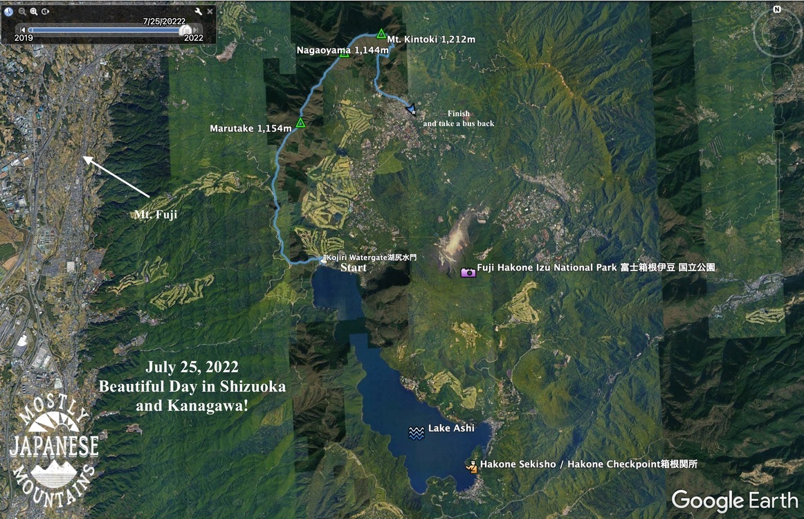
This hike was a strategic culmination of a sort.  Lake Yamanaka and Lake Kawaguchi to the west have been targets of mine for the past year or so.  On the Kawaguchi/Tsuru-shi side, I've hiked all the trails from Otsuki to the top of Fuji and also to the north of Lake Kawaguchi.  Until yesterday, I had made only one foray down to Lake Yamanaka on a trip over Mt. Shakushi.  On the eastern side, I've been slogging along the ridgelines to the west of the Doshi River for seemingly an eternity.  Yesterday, I finally reached the lake on that side--and I connected up with the spot where I hiked down to the lake before from the west side.  In military terms, I executed a pincer movement.  🤣

The bit I did yesterday is traced in red.  The pink, orange and white lines are along the Doshi Road.  The yellow, blues and green are on the Kawaguchi/Tsuru side.


Let me get the statistics and details out of the way.

Getting there:  I took my scooter and parked it by the (湖北バス停) Kohoku Bus Stop.  Obviously, you could get there by bus.

Getting around:  There are bus stops all around the lake.  There are also rental bicycles (and rental swan boats.

The hike:  I hiked from the bus stop to Mt. Ohira, Mt. Hirao, and Mt. Ishiwari along with seven other mountains not even worth naming.  I went as far as the Yamabushi (山伏) Pass just because that is as far as I had been before when coming from another direction.  There is nothing there, so I wouldn't set that as a destination.  I hiked 20.3km in about 6.5 hours.  It was fairly gentle and it didn't seem that far.  The lowest point was 985m and the highest was 1,437m.  During the hike I went up 1,275m and down 1,277m.

When I came out of the mountains, I walked along the north shore of the lake for the last 40 minutes or so.  That was a nice end to the day.

Facilities:  On the trail, there were benches and the occasional roofed structures at appropriate places.  There are no restrooms, waterholes or commercial entities on these trails.  Down by the lake, there are cafes, and the like.  

Recommendations:  By all means, do this.  I would recommend hiking up as far as Ishiwari.  That has a great view.  I think winter would be a great time to do this when it is clear and you can get a great view of a snow-covered Fuji.  

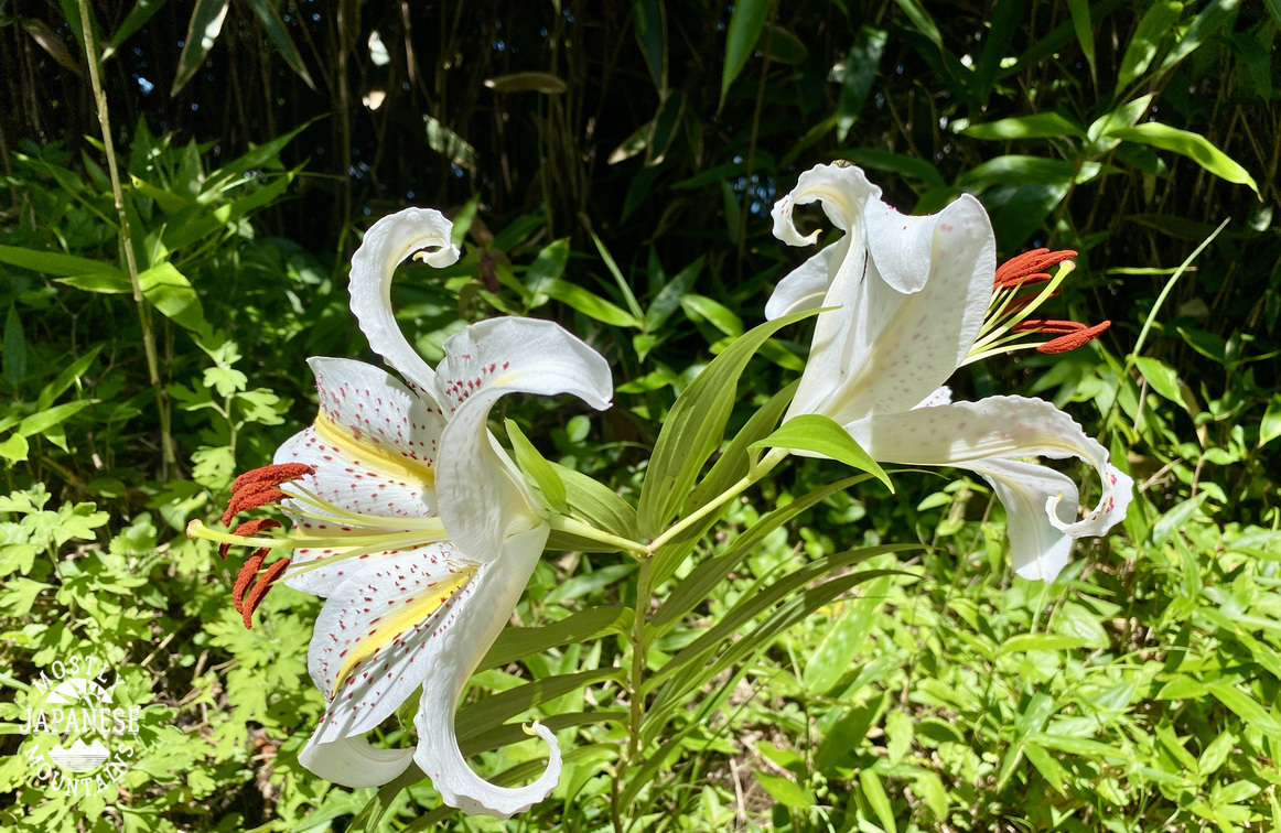
If you like flowers, you might want to take a turn to the west and check out the municipal flower garden.  I passed through that on a previous hike.  It's pretty enough that a newly-married couple were there having their pictures taken.  Yamanako Hananomiyako Park  That park is 花の都公園 on the left side in the next picture.


Let's look at some pictures.

This first one is one I took of the area from Mt. Fuji last August.


The trail was quite gentle most of the way.  There was a lot of wet grass to go through, though.  My feet were soaked after a while.


The Katsuragawa (Japanese Judas Tree River) starts here.

"Lake Yamanaka is the source of the Sagami River!  Let's all lend a hand in keeping it beautiful."

Fun fact:  You can collect swan feathers along the shore of the lake.  That was what I brought home to Mrs. Caveman.


I found a legit swimming hole!  I have been looking for one on the Doshi River forever!  It's deep enough to really swim in.

Subscribe to the blog and I'll tell you where it is.  It will be our secret.


I was the only person there for a few minutes until a young couple drove up.  I could relate to the guy, he was as excited as a little boy.  😁  He stripped down to his underwear and went in the water.  
His girlfriend wasn't having as much fun, though.  She stayed covered from head to toe against the sun and didn't go in the water.  (I don't think this bodes well for their future.)

I wanted to cheer her up, so I gave her a few of the swan feathers I'd collected.  I should have given them to the guy.  She seemed determined to say no to fun.  🙅  


Like I said, subscribe to the blog if you want to know where the swimming hole is.  

I average a little better than a post a week, so do subscribe so you know when the next one is posted.  I have a trip to Fuji and a trip to the Northern Alps on the calendar so don't miss those posts.

That's all for now.  Take care.  Drop by the cave again real soon.


Doshi Mura, Part II. The saga continues.

When last we saw our hero caveman, he was avoiding Doshi Mura in order to chase the blue skies in more picturesque places.  

Today we pick up the tale as he returns to Doshi Mura to complete some un-finished business.

Here how things looked earlier this week.


. . .  and here's how it looks now.

That looks better nicely tied-up like that, doesn't it?

The theme song of my last hike was "Blue Sky."  For this one, it was this tune by B.J. Thomas.

The weather forecast looked good and the morning was nice.  Driving into the mountains, most of the sky was blue except for some fog/clouds here and there swirling around some of the peaks.  I wasn't worried.  Meteorologists are amazing prognosticators, after all.


This is the Doshi River.  Tsuribori means something like stocked fishing pond.  Along rivers, it means an area where small pools have been created to facilitate fishing.  At a tsuribori establishment, you can have the proprietors roast up your catch for you on the spot.


For this hike, I drove up the road connecting Doshi Village and Tsuri City, Route 24.  I parked next to the tunnel and hiked from there.  Up there it was more misty and foggy than it was lower down along the river.


For the first half of the hike or so, it was misty.  It was a Blair Witch Project kind of day.  I'm pretty sure I saw a bigfoot.


The weather was ok with me.  This trail offers little in the way of long views and I like the fog and mist.  Misty mountains remind me of J.R.R. Tolkien or Led Zeppelin.

This is the highest point on my journey, Mt. Mishotai.  There is nothing to see from here.  It's one of Yamanashi's 100 Famous Mountains.  I'm not sure why.  It's certainly not because of the view. 

It wasn't long after I left this spot that the rain came.  The rest of the day was like this.


It was quite literally like that.  When I got off the trail a few hours later, it was still raining and I changed my clothes in the woods before getting on the scooter to head home.

I hadn't driven more than 5 minutes down the hill toward Doshi Village before the rain had stopped and the temp. was over 32C (91 degrees f).  Everyone I talked to said it was a hot sunny, day without a hint of precipitation.  I really had been followed by a cloud like Charlie Brown.

Details of the hike

Start and finish:  Michizaka Tunnel on Route 24.  

Getting there:  Bike.  You could get there by bus from Okajimashokuhinkan which is a 5 minute walk from the Tsurubunkadaigakumae train station.  (Although, I'm not sure why anyone would.  The only reason I can see for doing this hike is if you are kind of O.C. about walking every trail like I am.  😂 )

Stats:  Lowest point, 1,023 m.  Highest (Mt. Mishotai) 1,681m.  Change in elevation while climbing: 1,805m up and 1,816 down.  Distance: 17.7km, just under 11 miles.  Time: 7 hours. 

Best part of the day:  I only saw two people.  

Recommendation:  Skip this trail unless you are a gourmand of hiking trails like I am.  I think my favorite mountain near this area is Mt. Shakushi which is to the west of Mishotai.  You can reach that from one of the stations in Tsurushi.  That has a kick-butt view of Fuji.

The general area:


That's all for today . . .

I'm still on vacation so I am sure I'll be out again soon.

Have a good one!


Post #101 Kintokisan, Gorgeous day in the Fuji Hakone Izu National Park

 Greetings cave dwellers.  Thank you for dropping by again.  Pull up a rock.  Make yourself a smore.


Astute readers (ie, me and probably nobody else) will recall that my last post was a "Part 1" and therefore probably expected this to be a "Part 2".    Well, if you did, you were wrong.  

This is a blog about mountains so the occasional cliffhanger is to be expected.  Just hang on.

I will get back to Doshi Village someday.  Don't worry, I am not a serial killer.

Yesterday morning I was heading to the same area I went to last week to continue my adventures around the Doshi Village but changed my mind on the way.  My hike in Doshi Village doesn't promise very much in the way of beautiful views and I really want to do it just to say that I have done it.  There's nothing wrong with that.  A so-so day on any mountain is better than any day just about anywhere else.  Yesterday's weather was just so special, though.  It was a short window of clear blue skies opened up between long periods of rain and clouds or haze.  The majestic glimpse of Mt. Fuji I caught as I was going through Doshi Village made me abruptly adjust my plans.   I decided to take a trip to Mt. Kintoki in Hakone for a hike that has been on my bucket list.  


I don't know where I heard of Mt. Kintoki, but it ended up on my bucketlist somehow or other.  I have been to the other side of Ashinoko (Lake Ashi) many years ago to visit the historically significant tourist attraction of the Hakone Checkpoint.  I vaguely recall taking a boat ride, too.  I intend to get back there someday.

Lake Ashi is quite a resort area.  All of Izu is.  There are several ropeways up to the mountains.  It's a golfer's paradise.  There are numerous resorts and onsens.  There are great views, of the lake, of the Sagami and Sugura Bays and, of course, of Mt. Fuji.

Here are the details of the hike.  This is just a hike I came up with on a whim one day.  There are trails all around the lake and if you don't want to go to the particular area I did, I am sure you can find something suiting your desires.  Getting around the area is easier than I had expected.  There are bus stops everywhere.


Getting there:  In my case, I took my scooter.  That made it easier for me to get to the north side of the lake.  It was about 110km from my home.  It took about 3 hours of driving.  If going by public transportation, most people go to Hakone Yumoto Station to the northeast of the Checkpoint first (a little over an hour by shinkansen from Tokyo Station) and then take buses to where they want to go.  The Hakone Checkpoint is 52 minutes by bus from there.  The time and the train and bus changes are the reasons I haven't been there in so long.  As the crow flies, it's not far.  As the trains and buses run (or even cars), it's a hassle.

Getting around there: is surprisingly easy.  There are bus stops everywhere.  Just be aware that there are many different bus companies and you need to pay attention to exactly which bus stop and bus it is you need. 

The hike:  I like water, so I decided to start at the lake.  Starting this far away enabled me to hit a few peaks on the way to Mt. Kintoki.  It was about 12.5km and had an elevation change of something like 970 meters up and 1,070 meters down.  The trail, for the most part, was very gentle.  There were almost no chains or ladders.  Anyone could do it.  I think the word for the day was pleasant.  There were several places along the way accessible by car that could shorten the trip.  I exited the mountain at the Kintoki trailhead.  As you can see, that was quite close to the top.  I did this in just under 5 hours.  I don't run, but I'm faster than most.

Facilities:  No water on the trail until the top of Mt. Kintoki.  There were free public restrooms along the way.  At the top of Kinotoki, there is a paid restroom.  Also, there are two little mountain huts at the top.  They had plenty of food and mountain swag.

Let's look at some pictures.

Most people probably have no idea that you might hear loud noises coming from Mt. Fuji.  I took these videos from Lake Yamanaka on my way yesterday.  The bangs are from USMC howitzers at Camp Fuji.  They were firing a lot yesterday.  Made me nostalgic for my days with my 11C platoon.


Motorboat prices (up to 5 people)
Once around the lake ¥10,000
Special Course ¥8,000
Halfway ¥6,500
Pedalboat (3 people) 30 minutes
swanboat ¥1,500
Rowboat 30 minutes
2 people¥1,000
3 people ¥1,200
"We also have fishing boats and motorboats available."


I stuck my hand in the water here.  I was surprised how warm it was.  
The lake is very clean.


I was able to pick out this watergate from the mountains.  I couldn't believe how far away it seemed.


This is near the beginning of the trail.  Much of it was like this.  Not too drastic a slope and surrounded by vegetation.  

The cicadas, of course, were loud.  The birds were chirping away.  The atmosphere reminded of the Allman's song, "Blue Sky".  It was not only picture perfect, but song perfect.


That sandy, smokey area to the left of center is the Owakudani Valley.  It is traversed by a ropeway.


Here's a view of the watergate


It's the season for mountain lillies.


The top of Kintoki.


I'll put this up in case you want any explanation of the background of the name of the mountain.  I'm sure this will clear things up so much no more explanation will be necessary.  


Maybe this will help.


You may be seeing this picture and assuming it's really delicious.  Actually, it's not.  It's my failed attempt at making calzone.  It was so bad that I kept the leftovers until I could eat them in the mountains.  Since everything tastes better in the mountains I figured I could stomach it here if I could not eat it at home.


Kintaro hard candy*.  There is a story behind this.  

*How they make it is kind of interesting.  Look for a video on youtube if you want to know how.


If I climb one of the 100 Famous Mountains, or if I go to an exceptionally cool mountain, I might buy some swag.  Not often, though.  I'm a cheapskate.  

I liked the ax on this mountain so I broke open my wallet and bought this 手拭い ("tenugui", ie, handcloth) from the Kintaro Chaya on the top of the mountain.  Tenugui are very light, cotton cloths and are super useful for hiking.  I always have two or three when I am hiking.    


The proprietor of the Kintaro Chaya was a really sweet obaasan (old lady).  When I bought the tenugui, she presented me with that Kintaro candy and some other sweets.  She even split a popsicle-type thing in half and gave half to me and half to another customer.

I was so struck by just how nice she was that 5 minutes down the trail I decided to go back and buy a t-shirt.  For plunking my dough down for the t-shirt, I was rewarded with another popsicle.  This time a whole one just to myself!


The Kintoki Yadori Stone.  Kintaro was born here.


That's all for now.  I am dying to get out there again.  I have a lot of time off and more places on the bucketlist . . . but it's raining.  There is rain in the forecast for something like the next 10 days.  Keep your fingers crossed for another window like yesterday.

Take care.