Greetings and salutations cave ladies, cave gentlemen and cave children of all ages. Today I'd like to tell you about a trip to Japan's Northern Alps region.
First, let me give you some details and stats. Then I'll show you some pictures.
Location:
Japanese Northern Alps (The Hida Mountain Range). The border between Takayama City, Gifu Prefecture and Matsumoto City, Nagano City
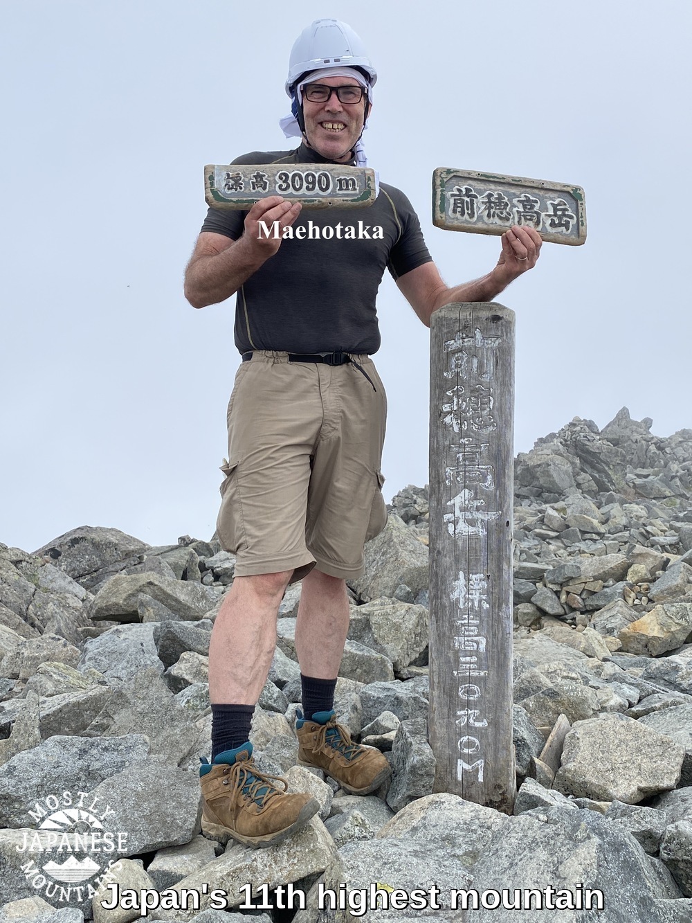
Maehotakadake, Okuhotakadake. These names are often shortened to "Maeho" and "Okuho."
A word on the names. The main name for this collection of peaks is Hotakadake. "Ho"means something like "ear" (of corn) or "point" and "taka" means "high." "Dake" means "peak".
The peaks specifically are "Maehotaka", "Nishihotaka", "Okuhotaka" and "Kitahotaka." "Mae"="front." "Nishi"="west." "Oku"="inner part" or "recess." "Kita" means "north."
Getting there/getting around:
Private cars aren't allowed as far as Kamikochi. You must take a bus. You can get one from Matsumoto or from far away exotic places like Shinjiku or Tokyo. One bus company is here: Alpico Bus . This web site has great access information. Access Leave a comment to ask me for advice if you need help choosing a route from where you are.
3 days/2 nights 18 hours, 51 minutes hiking (but we were sloooooow)
Elevation:
Lowest point: 1,500 meters Highest: 3,190 meters. Total ascent 2,200. Total descent 2,200 meters.
Technical considerations/difficulty:
Fairly challenging. Part of this route, from Dakesawa Hut to Kimiko Daira, has the steepest ascent in the Alps. There are many places with chains, ropes or ladders. There are many spots that necessitate climbing with both hands and feet. Much of the route is above the tree line and some spots are quite exposed. All that said, this route to Okuhotaka is not as challenging as the Nishihotaka side, the Gendarme or the Daikiretto to the north. Those demand more technical ability and strength. Helmets on the route we chose are definitely recommended but ropes and harnesses aren't necessary. This site is a treasure trove of information on all things Kamikochi. Kamikochi trekking information
Facilities:
There are several huts in the area where food and lodging are available. Each of the huts typically has tenting sites and even rental equipment to the point where going camping "tebura"* is possible. (*"tebura" "手ぶら" means "hands hanging by one's side", ie empty-handed) Along with the usual souvenirs and snacks, mountaineering clothes and boots are available for purchase. Kamikochi is really an Alpine paradise of sorts. Each of the huts has pay toilets as well. On the trail, there is nothing between huts. I always wonder what females do about the call of nature up there. I know what I do. Shhhh. Let's keep that between us. 😉
Thoughts/observations:
I wish I had the time and money to do a trip like this every day. What a place. The weather wasn't the best for this hike but it was still great. August in Japan does not offer too many clear skies and it was a bit of a disappointment not to get any completely unobstructed views of the mountains from the bottom or of their surroundings from the tops. The best season for hiking in the area is fall. The air is crisp and clear and the fall foliage is gorgeous. Unfortunately, that's when all the people show up. The place we tented at the second night has sites for 800 tents--and it does get full during leaf-peeping season. The caveman goes to the mountains to get away from people so a few clouds in August is ok by him.
This is in the Visitor's Center
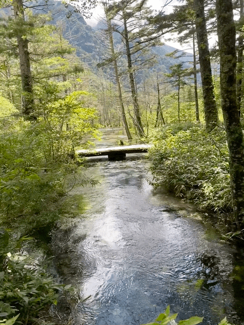
Just a few minutes up the trail and we reached this famous bridge which is called Kappa Bashi.
The Azusa River is so clean. I don't think I have ever seen such clear water in a river with so much volume.
This sign is similar to warnings I've seen a million times. "A bear was sighted at so and so on such and such a date." Usually it's sometime long previous. This is the first time I have ever seen a sign dated the same day I was reading it and for the exact place I was going. Yikes.
After walking a bit by the river with all the crowds, the trail starts and the crowds thin out.
This is a nice place to cool off. Cold air emanates from the cave.
A rare sighting of the sun. It was hiding for a lot of this trip.
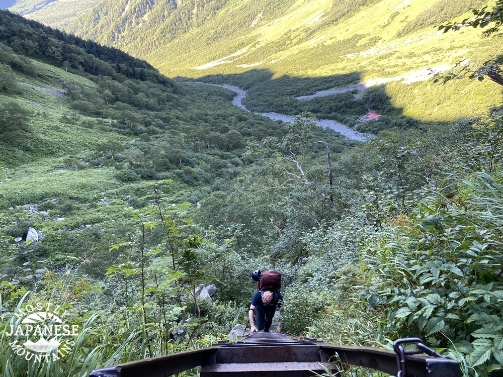
On day 1 we hiked up to the Dakesawa Hut and pitched our tents nearby. From there we could see the ridge we would be walking along the next morning.
Day 2, looking south from the Dakesawa area just after starting out.
Caleb with the Dakesawa Hut in the background.
It was around this point that Caleb realized his boots were falling apart! Both his right and left soles picked this precise moment to start falling off. This was a potential disaster as we were already well into our trip but luckily he was able to hold the soles on with tape he had in his first aid kit. They don't call him MacGyver for nothing. (Actually, they don't, but I think they should.) He applied tape at this point and again the next morning. That tape held up for 10 miles! Thank God.
*Note to self. Put tape in first aid kit.
**Note to self. Make first aid kit.
Shortly after Caleb had his blowout, we separated for a bit. I took the spur up to Maehotaka while he kept heading on to Okuhotaka. We figured we should try to lessen the burden on his boots as much as possible. Since he was moving slowly, I was able to get to that summit and back on our trail to catch up with him around lunch.
This is where the trail up to Maehotaka starts and where we parted. Maehotaka is about 25 minutes up and 25 minutes back to the ridgeline trail to Okuhotaka.
Do you like my helmet? I didn't have one before this trip. I didn't feel like shelling out the money for something with a brandname on it so I went to Workman, a store that specializes in clothes and equipment for construction workers. It worked fine.
I am not the first person to think of this. A Japanese guy started chatting me up on the trail by noting how big my pack was. I told him I'm けち (cheap) and so was tenting instead of staying in a hut. We both chuckled about being cheap or broke and I pointed at my helmet. He got really excited and pointed at his, saying "Mine, too." His had a Montbel sticker on the side but he said, "sticker only, not real one." 😂
Speaking of helmets. Rentals up there are available. I'm not 100% sure of locations renting them but you need to come back the same route so you can return it to the place you rented it from.
Some pictures from the Tsuri One. (吊り尾根)= "Suspended Ridge"
After getting up and down Maehotaka and walking along the south side of the Tsuri Ridge for a bit, I got my first look down below at the Karasawa Hut on the other side of the ridge. That's where we would pitch our tents for the second night.
I think it's so cool to see snow in August.
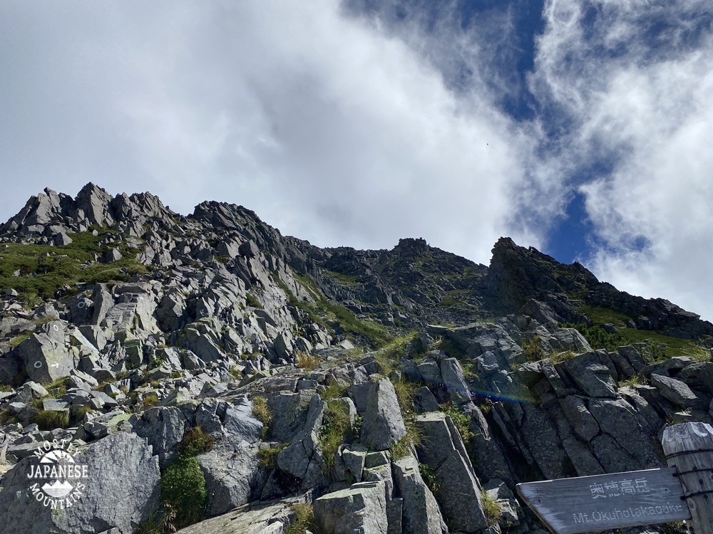
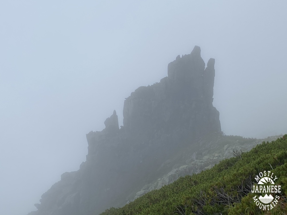
The top of Okuhotaka.
That is called a "raicho" (雷鳥) in Japanese. It is grouse or ptarmigan in English. I like a more direct translation of the Japanese though--"thunder" "bird".
This hundred meter or so drop to the hut was pretty gnarly. You really need to watch where you put your feet and hands.
This hut was closed except for tenting from August 21 through 27 because someone on the staff got COVID. I hope they're ok. That closing must have inconvenienced a lot of people.
Let's have a moment of silence. This sign gave its all for you and me.
This is the information board at the Karasawa Hut. Obviously you see the weather and other bits of information. On the left are statistics about rescues and accidents from July 1 until August 22. The map shows the locations. The blue and white paper on the bottom in the middle shows the causes and resolutions of the accidents.
If it ain't raining, it ain't training.
People make fun of my big, bulky, dorky tent. I like the roominess though.
We convered more distance on day 3 than on days 1 and 2 combined. After a few hours coming down through scree and mountain trails from the Karasawa area, we hit pretty flat trails next to rivers that would lead us back to the Kamikochi Bus Terminal.
The Hondani Bridge
Let's hear it for Caleb's boots. That repair held up for ten hard miles.
His boots more than earned this badge of honor.
Well cave cats and cave chicks, that's it for today. I can't wait to do something like this again.
Take care of yourselves. Stay dry and always carry some tape.
Leave a comment. Subscribe. Buy me a coffee and I will contribute to Caleb's boot fund.
Want to see a report on Japan's second and fourth-highest mountains? Check out Kitadake and Ainodake. The grandaddy of them all is Mt. Fuji, of course.
Greetings and salutations to cave dwellers of all ages and sizes.
I'm happy to say that I was able to get out to my mancave again yesterday. This time I was able to knock off a few more peaks in the Fujigoko area. Yesterday I was hiking along a ridgeline north of Saiko ("West Lake"). Let me give the hard-cold facts first and then I'll tell a bit of a story with pictures.
Location: Ridge north of Saiko. Mostly in Fujikawaguchiko
41 minutes by bus from Kawaguchiko Station. The first bus (on a weekday in August) leaves at 9:10 am. The last bus back leaves about at 3:50 pm. Check ahead!!! Then check again. Bus schedules are seasonal. Fujikyuko Bus English information
Lowest: 910m. Highest: 1,738m. Total Ascent: 1,458m and Total Descent 1,459m
Technical considerations/difficulty:
Some ropes and steep spots necessitate some upper body strength. Some of the steep spots are a bit slippery so you must watch your step.
Facilities:
Nothing on the trail. No water, toilets or commerce. The parking lot at the Iyashinosato Nenba place is free. There are vending machines there and (seasonal, I'm sure) restaurants and souvenir shops just outside the Iyashinosato Traditional Village. I don't think there is even a public toilet there unless you pay the admission fee and actually enter the Traditional Village.
Thoughts/observations:
I was more pleased with this hike than I expected. My first visit to Saiko left me unimpressed. I descended to the lake from Junigatake after hiking over from Lake Kawaguchi. Mt. Fuji isn't really visible at the lake level there so the views weren't great. I must say the views from above the lake and, at water level also on the west side, are really great. This hike could definitely be done year-round but I would bring spikes in the winter. If you want to hike around here, you might want to skip the last peak I went to. There was nothing to see. I only went that far because I plan on continuing this trail at a later date.
Today was the first time I've seen actual crowds of tourists in a long time. The campgrounds are full. The lakes are dotted with people in various boats and SUPs. I was happy to see Japanese getting out and enjoying themselves. I'm happy for the tourist businesses, too. I didn't enjoy the traffic coming home, though. 😂
If you looked very closely at the map, you may notice there are two mountains pronounced "Settodake." If you looked even closer, you might notice that the Japanese characters for the two mountains are different. This is a particularly frustrating aspect of the Japanese language. Because the writing system is based on ideographs, there are a lot of homophones that are written completely differently and mean different things. The fact that these mountains are in spitting distance of one another adds another level of danger of miscommunication. Yesterday I had a conversation on the trail about Settodake with another hiker only to ask myself later if we were talking about the same place.
One other thing about one of the names of these mountains. One of them is Onidake. "Oni" (Owe knee) means ogre or demon. It is also the word Japanese kids use when they play tag. In English, we'd say, "You're it." In Japanese you say "O mae ha oni da!" (You are the oni!)
These days the first rays of the sun wake me up. That is useful for these hikes because it's about a 3-hour ride to get to the areas I've been going to lately. Yesterday I was wondering upon awakening if it was a good idea to go--the weather forecast wasn't spectacular and it's a drag to go so far and then be denied a picture-perfect day. And couldn't my feet use a break anyway? Blah blah blah
Nothing ventured, nothing gained. My hesitancy about the day usually dissipates by the time I open my front door and head outside. I'm always happy that I just go.
Of course, I was happy that I went.
It was a nice ride.
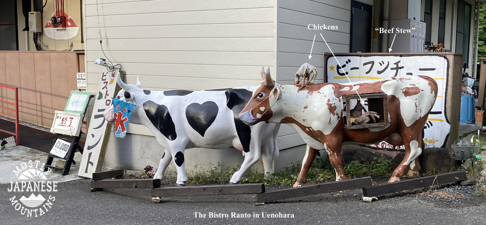
These two pictures from the road are exemplary of the random weirdness I encounter in Japan that bewilders and amuses me.
Almost there . . .
One of the things I really like to do is to identify the mountains I've been on in the past. Hiking around Mt. Fuji makes this especially fun because it gives such a great vantage point to look in all directions. I took this picture quite a while back from Mt. Fuji and it takes in where I hiked yesterday as well as a couple hikes I made one week previously on Mt. Ryugatake and Mt. Omuro.
From yesterday's hike:
That was way more information than you wanted, I'm sure. I liked playing with the pictures, though.
On to yesterday's activities.
Off to the trail . . .
It was steep getting up to the first mountain but once at elevation, the view was worth it. This ridgeline has great views all along the way.
Mt. Kagitake. Not the most exciting mountaintop.
This is the marker for the last mountaintop of the day. Not exactly breathtaking.
The last couple miles were on an old paved road.
These last several photos are not of the mountain but of the Iyashinosato place. Being sweaty and carrying my backpack, I wasn't into this type of sightseeing thing but if you were sightseeing around Saiko I think this would be a nice place to spend a few hours while getting a sense of what life was like here back in the day.
There are various and sundry exhibits, restaurants and shops.
This sign says "Koshu Silk". If you are familiar with Tokyo, you may know Koshu Kaido (Street). It runs past Shinjuku Station. Koshu Kaido, which runs out to Yamanashi, to a city named--wait for it--Koshu City, was the Japanese silk road.
The Caveman is a cheapskate but he pried his wallet open here just long enough to buy Mrs. Caveman a souvenir.
Well, like Porky Pig says, "That's it, everyone." I have one more excursion planned for this summer vacation that I'm really excited about. Stay right there on the edge of your seat and I'll give you a report next week.
Or better yet, subscribe to the blog to get notified without having to wait on the edge of your seat. You do that by pressing the giant round button that says "subscribe" below. Easy-peasy Japaneasy.