Greetings cavedwellers.
I was happy to get out yesterday and visit my mancave. I've been chained to a desk for the past two weeks and was itching to get out.
I went to an area I've been spending a fair amount of time in in the last half year or so; in the hills just north of Fuji. For this trip, I started at the Fujikyuko Line's Mitsutoge Station. I've used this station before when hiking up to Mitsutoge Mountain to the west. This time I headed east up and over Mts. Kurami (倉見山), Shakushi (杓子山), Shishidome (鹿留山), one or two other mountains I can't read and then descended from the Tatenozuka Pass (立ノ塚峠 ) to Lake Yamanaka.
It was a glorious day.
Let me give get the minutiae out of the way. Mitsutoge Station is on the Fujikyuko Line. You can connect to that from Otsuki Station. Otsuki Station is about 75 minutes from Tokyo Station. Mitsutoge is another 20-30 minutes from there. You can also get to the general area by highway bus. I'm not a travel agent, though, so I'm not giving any more details. There's this thing called google. Try it sometime, if you want directions. (To be serious, though. If you want some help getting around, leave a comment. Even with googlemaps, getting around in this country can be a challenge.)
Here's what the hike looked like.
This is what the area looks like from above. I took these on Mt. Fuji last August.
It took me about 7 hours, including time for breaks and lots of pictures. This hike entailed a rise of elevation of 1,645 meters and a drop of 1,278 meters. My initial plan was to turn back toward the Fujikyu Line at Mt. Shakushi but I couldn't help myself from continuing on all the way to Lake Yamanaka. When I arrived there, I found myself just a few hundred meters from a highway bus stop with a bus running to my neck of the woods. I only had to wait about 15 minutes. That was great luck!
This is Mt. Mitsutoge. It is supposed to have a really great view of Fuji. I have to take everyone's word for that. I've climbed it twice and it was cloudy both times. Regardless, it's a cool mountain to climb. There are some mammoth rock faces near the top that attract a lot of rock climbers. The antennae on it are easy to pick out from tens of miles away so it's a great landmark.
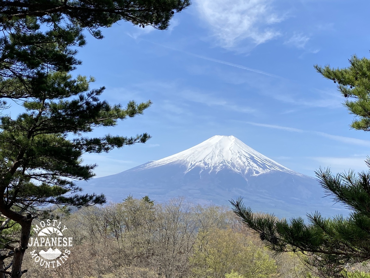
This view of Fuji is one of the first things I caught on the trail. That river is the Katsuragawa. That will appear in this post later on as well. Stay awake or you'll miss it.
This is the scenic overlook at Mt. Kurami. Very nice! I can't tell you how many times I've schlepped all the way up a mountain to get to one of the signs telling me what a great view it is--only to be greeted with clouds.
Is it just me, or does it seem like Mt. Fuji was into the sake yesterday? It's leaning to the side in all the pictures I took.
That one was leaning the other way. It's making me seasick.
I'm sorry to show so many pictures of Fuji. It was just too perfect yesterday. I had a lot of fun peering at it through my binoculars and picking out places I'd been. You can clearly see a lot of the switchback trails and bits of the bus route up to the 5th Station on the Subaru Line.
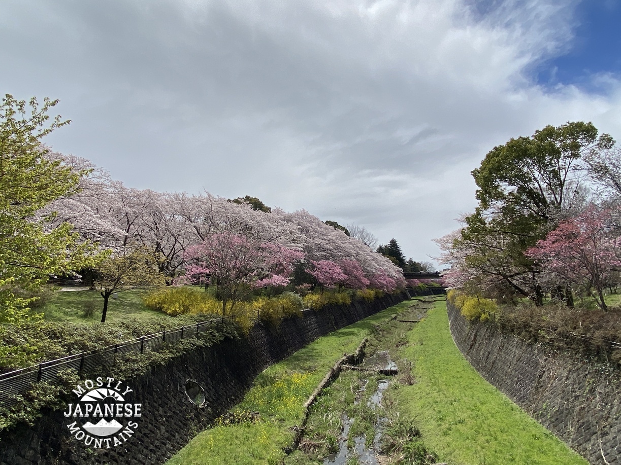
I was surprised how many cherry blossoms are still in bloom in Yamanashi!
I ran into some runners today. Literally. They were running the Ultra-trail Mt. Fuji Race this weekend. I shared the trail with those people for a few miles. I can't imagine how they do it. The race is 165 km. (That's just over 100 miles for us Americans.)
This is from the top of Shakushi. It really is one of the better viewpoints I've had of Mt. Fuji. The people in the picture are support staff for the race. The sign on the bell has 杓子山 (Mt. Shakushi) 1,597.6 written on it.
I deadicate this one to any deadhead spelunkers out there.
In case any of the deadheads haven't figured out what was going on two pictures back, maybe this will help . . .
Speaking of impaired entities, did you notice Fuji's posture there? It's going to tip over and pass out any moment. What kind of self-respecting national symbol would allow itself to slip into such a state? It's time for an intervention. Anyone know a counselor with an office big enough to accommodate an intervention by a few of Fuji-san's friends? I think we should invite Everest and Mont Blanc. Maybe Mt. Mckinley would lend a hand.
Coming off the mountain, I walked another few miles toward the lake. It was a great walk because I was walking straight toward Mt. Fuji the whole time and was treated to so many good views.
This is at the Yamanakako Hananomiyako Park. I didn't enter, but it looks like a nice place.
My destination for the day!
Lake Yamanaka
I end up where I started. I never realized that the Katsura River starts here at the Lake. I knew the Katsura River before because I knew it drained into Lake Sagami but I never knew its origin was Lake Yamanaka.
Drop by the cave again sometime.
Some of the Japanese words that appeared in this post and approximate translations. Translations of place names are often weird so don't get bent out of shape if you don't like my translation:
鹿留 "Shishidome" means something deer stationary
桂川 "katsura gawa" Japanese Judas Tree River
倉見山 "kuramiyama" warehouse look mountain
三つ峠 "mitsutoge" three (mountain) pass
立ノ塚峠 "tatenozukatoge" Standing House (mountain) Pass
山中湖 "yamanakako" Lake In the Mountains
That's all.
Caveman out