I'm in a hotel tonight that has a big screen TV. I realized I can watch youtube on it and ended up watching movies I've posted of the mountains. Wow. I have never seen them on a screen larger than my laptop. If you can watch my movies on a large screen I highly recommend it!

big screens are cool!
 I'm the caveman. My mancave is the mountains. Google dislikes me so nobody can find my blog. I keep doing it though, because I want to remember all the great places I've been able to see and I have a bad memory.
Caveman climbs Mt. Akagi, the red castle. One of Japan's 100 Famous Mountains.

赤城山
Mt. Akagi, Gunma
Location:
Mt. Akagi and environs, Gunma Japan
Starting and stopping point:
Peaks bagged:
Mt. Choshichiro ~ Kojizodake ~ Kagoyama ~ Komagatake ~ Kurobisan ~ Ashigara ~ Jingasayama ~ Yakushidake ~ Debari ~ Kita
Getting there/getting around:
There is plenty of parking near the main trails. There are a few bus stops around the lake but I am not sure of what their routes are.
Map:
Yama to Kogen Chizu --I don't know. I printed one out from this link. Searchable map link
Weather Information:
Time
Total Time: 6:13 Break time: :29 Distance: 19km
Elevation
Lowest: 1,345m Highest: 1,828m Total Ascent: 1,129m Total Descent: 1,129m
Technical considerations/difficulty:
This hike was not particularly scary or taxing. There are very few ropes or chains. The only really steep section is the slope direct between the lake and the peak of Mt. Akagi. That section is kind of interesting as it is characterized by fairly large boulders shaded by trees. Unfortunately, being the shortest route to the top, it is also characterized by a lot of people. I came down that way and thought that it must be a bit taxing going the other way. One other factor that affected the day was the wind. The temperature wasn't really cold but the wind was quite high and I was glad that I had a Goretex shell to wear over a fleece.
Facilities:
There are several restaurants and the like around the lake. There are also boats on the lake. Most of the businesses weren't open yet as Golden Week is still approaching.
Thoughts/observations/recommendations:
I can't say I didn't enjoy it. I did. That said, I almost wonder why this is one of the 100 Famous Mountains. Most of them that I have completed so far have been really, really special. This one was just really special.

After finishing the larger portion of the trip, I decided to go back and check out one more hilltop that I'd skipped in the morning. This is Mt. Kita. There is a sign on top but there is no trail to get there.

I'm not going to give a blow-by-blow account. If you're interested in going to the area, you'll discover for yourself the ins and outs of it. I'll just put up a bunch of pictures for your perusal.

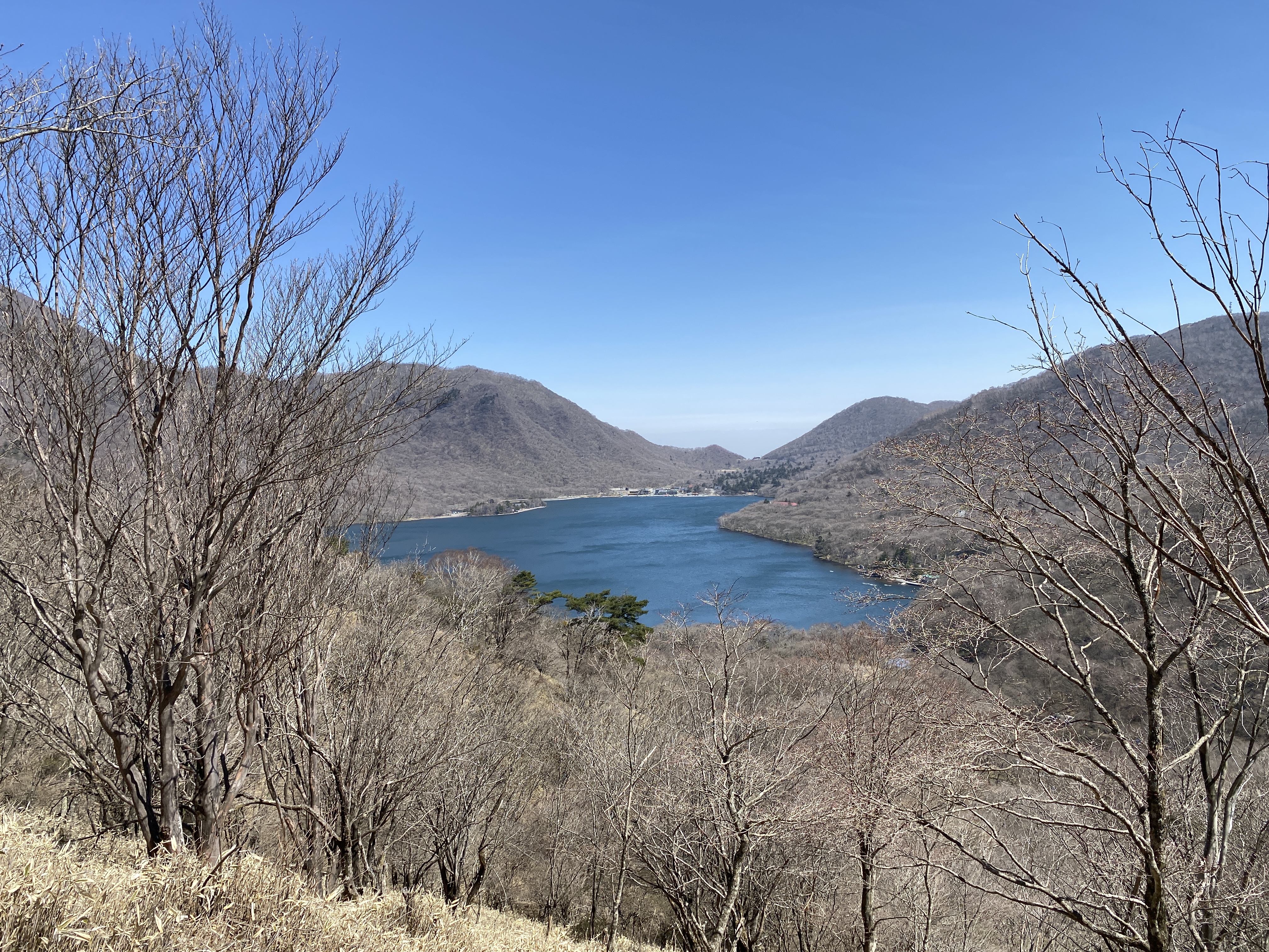
The first stop of the day was Konuma. That means small marsh.


I wrote before that I wonder why Mt. Akagi is one of the 100 Famous Mountains. On second thought, I can now see that the views from here on a clear day would really warrant putting Mt. Akagi on the list. There really is a lot in line of sight from this area.


Mrs. Caveman is visiting her family in the cave of her youth in the tropical paradise she hails from right now. Where she is, there is a heat wave and a heat index of around 50 degrees Celsius! I'll take the ice and snow here, thank you.


This is Kakumanbuchi (Kakuman Marshland) in the foreground and Lake Onuma beyond that.


Looking back on Konuma.


Some spots on these trails reminded me of hobbits.

Many Japanese hikers often put a lot of effort into eating gourmet food on the trails. They'll carry stoves with them and cook some really elaborate dishes and have a glass of wine on a mountaintop. That's not my style. I don't want to carry anything extra and I don't want to spend time cooking. If I want something hot, I just bring a thermos.
This day's "gourmet" lunch was ham and prosciutto on homemade bread. Yum.


After lunch on top, I came down to the water level before going back up into the mountains to swing around the west side of the lake.

The Akagi Shrine with the mountain above

These guys are well-fed and have really good rhythm.
I have to say that the carp up here can be really huge.
They are also eaten around where I live.


Mt. Akagi


This is Mt. Kita.


Home for the night.

Inside the campground

Maebashi City from the campground


This is the next day. I had business to attend to in Takasaki. That is a nice city.

The ruins of Takasaki Castle


I took this on the way home. I think one of those mountains is Mt. Myougi. That one is going on my bucket list, too.

That's all for today. If you read this far, thanks.
Remember to subscribe, comment and tell your friends about the crazy guy with the groovy mancave.
Want to see another of the 100 Famous Mountains? Kobushi
Caveman out
I'm the caveman. My mancave is the mountains. Google dislikes me so nobody can find my blog. I keep doing it though, because I want to remember all the great places I've been able to see and I have a bad memory.
I finally got my boots on! Arafune, the floating carrier.

Greetings cave dwellers.
I've been living in Nagano for a few weeks now and have really been loving it but between the move and starting a new job, I haven't had much time to spend in the mountains beyond a few trail runs. I finally got out about a week ago to a really nice mountain called Arafune.
The name Arafune (荒船) has the meaning of boat in it. The flat shape of the mountain seems to make it look like an aircraft carrier navigating the rough "seas" of the clouds below it.
Cool, huh?

Location: Mt. Arafune straddles the boundary between Nagano and Gunma.
Starting and stopping point: Arafune Fudoson Parking Lot
Peaks bagged: Mitake (御岳) Kabutoiwa (兜岩) Tomoiwa (艫岩) Kaminashi (神無) Kyozuka (経塚)
Getting there/getting around: There is free parking. I don't think there's any public transportation in the area.
Map: Yama to Kogen Chizu #21 西上州 妙義山・荒船山
Weather Information: Arafune weather
Total Time: 4:07 Break time: :11 Distance: 11km
Elevation: Lowest: 1,074m Highest: 1,423m Total Ascent: 970m Total Descent: 970m
Technical considerations/difficulty: I didn't find it that challenging but other people on the internet are saying it is difficult. There are some steep parts, but nothing too hairy as I recall. Maybe my impression is psychological. I was just so happy to be in the mountains that it felt like I was walking on air. There are a few spots where people can rock climb. Candle Rock (Rosoku Iwa) is one spot. I didn't do any of that, though. The trail between the highest peak, Kyozuka, and the most scenic spot, Tomoiwa, is especially flat.
Facilities: Moldy emergency hut at Tomoiwa. A picnic bench or two there.
Thoughts/observations/recommendations: There are good reasons this mountain is on the list of Japan's 200 famous mountains. The boulder formations are really cool and there are some great views.
I think the hunters in this area must be particularly bad marksmen. I have never before seen so many live deer at one time! I'm sure I saw more than 20 in the span of less than an hour. Check out the pictures and video in the post.
Highly recommend this if you get some time in this area.


I'm sure this rock has a name but I can't remember it.

I came up from that valley.

It must be climbed. Soon.

These two surely have names, too.
I wonder if one of them is Shirley.


On the flat stretch from Kozuka to Tomoiwa, I kept running into deer. I had to stop myself from stopping and taking pictures because I would never have made any progress if I'd continued doing that.


After passing all the deer, I came to Tomoiwa which has a great panoramic view.
BTW, Tomoiwa means "Stern" "Boulder." Neat name.


Mts. Tateshina and Yokodake are both part of the 100 Famous Mountains. I can see them from home, too. I'm scheming about when to climb them now.


I took this from the street on my way home. These hills are the ones on the eastern side of my route.


That's all for this post.
I got back from a camping trip last night and want to start working on that post.
Don't forget to subscribe and leave a comment. Then again, it's ok if you don't. I get enough endorphins from hiking. I don't need to be an influencer. 🤓 Have a spectacular day. Or not. It's your choice.
I'm the caveman. My mancave is the mountains. Google dislikes me so nobody can find my blog. I keep doing it though, because I want to remember all the great places I've been able to see and I have a bad memory.
Subscribe to:
Posts (Atom)