This morning I took a run up Mt. Hirao. Hirao is one of my go-to places if I have time for a run before the sun sets after work. It's located in the northeast of Saku City, just above the highway. It's visible from most of the city--and it has great views.
Getting there/getting around: I drove. There is plenty of parking. The parking lots at the onsen don't open until 8 but I was able to park at the highway parking lot.
Elevation:Lowest: 788 m Highest: 1,155 m Total Ascent: 727 m Total Descent: 727 m
Technical considerations/difficulty:
There are a variety of trails that I used on this run. There are hiking trails, ski trails and some forestry roads.
I lost a lot of time by trying to run under one particular ski lift. There are two lifts I ran under. The one on the lower half of the mountain is easy to proceed up. The entrance to the hiking trail is near the top of that lift. Until today, I'd always left the ski trail there and entered the hiking trail. This morning, I tried to continue toward the top following under the upper ski lift. This turned into a slow exercise in bushwhacking up a very steep, prickly, wet, slippery slope. I lost a lot of time there but got to burn a few calories--and collect a few scrapes and scratches to the delight of my inner-9-year-old.
Most of the trails and some of the roads up here aren't on maps. It's quite easy to get twisted around. I would stick to the marked trails if you don't have some kind of gps device.
Facilities: Nothing on the trail.
Thoughts/observations/recommendations: Do it if you can.
S'up, Peeps? The Caveman here with another report from the cave.
I got to climb a mountain in Tochigi yesterday. Straddling Gunma and Tochigi Prefectures, Mt. Shirane is one of the 100 Famous Mountains and is the highest point in both prefectures. The side in Tochigi is located in the resort town of Nikko. Nikko is really a world treasure. Their marketing slogan is "Nikko is Nippon." It fits.
Lowest: 1,487 m Highest: 2,577 m Total Ascent: 1,569 m Total Descent: 1,569 m
Technical considerations/difficulty:
There are a lot of steep parts and this was a fairly long hike. A lot of it is above the treeline, so it has the potential for adversity in bad weather. It's comparable in the change in elevation and distance to climbing Mt. Fuji from the Fujinomiya Trail. Of course, the top of Fuji is over 1,000 meters higher so the air is thinner but this will give your body similar wear and tear.
I took the longest route I had available--from Yumoto. I'm glad I did. One other choice would have been to go from the Kosei Pass to the north. The most popular route is the shortest and easiest from the west. By using a ropeway on that side, the hike is considerably shorter, but a lot more crowded. I could not believe how many people were on the top when I got there!
Facilities:
The Yumoto area has a ski area, a beautiful lake for fishing, many onsens, hotels, and a great visitor's center. On the trail, there isn't much. There is an emergency hut between Mae Shirane and Shirane but nothing else on the trail.
I also listened to a BBC History Extra podcast about the Great Kanto Earthquake. It was fitting because it was 100 years ago on September 1. A link to the online post about the earthquake is here.
Thoughts/observations/ramblings:
Mrs. Caveman is really nice to put up with me.
I hate bear bells. 🐻🔔 With a passion. Please. Just. Stop. Bear bell people use them all the time. There's no need in the middle of the day when there are a lot of people around. The bears already know there are people nearby. Nothing makes me scratch my head so much as seeing someone in a place like, say, Mt. Takao (aruguably the most heavily-trafficked "mountain" in the world) wearing a bear bell.
Incidentally, these people often have brand-new, top-of-the-line mountainwear. All boot and no trail. Yet, I digress.
It's like bringing shark repellant to a swimming pool. It's like using an air horn when pillow talk is enough.
I'm so upset by this topic, I can't even think of a really witty metaphor. Hmph!
Musing on this peeve as I was hiking yesterday, I recalled planning a hike with my friend Mike last week and telling him that if he brought a bear bell I wouldn't take him hiking. As I reflected back on this comment I kiddingly made to him, I realized I really did mean it. If someone showed up with a bear bell when I went to pick them up I would leave them at the station. 😜
Don't get me wrong. Hiking in secluded areas, particularly in the dark, is another story altogether. But a bear bell is as necessary on a busy mountain as one is in 7-11.
Rant over.
Nikko is such a lovely place. This was my first time in this corner of Nikko and I was surprised at how much more there was to see that I hadn't seen before. Here are some pictures.
These little videos are getting cooler. Now you can see pictures I took on the trail.
Starting out, at the base of a ski trail.
That's not the bear bell guy. The bear bell guy is way down the trail where it first becomes visible coming out of the treeline.
I could still hear his bell here.
At one bend it the trail, I noticed a mountaintop on my map that was off the trail. I couldn't help but bag a peak if it's so close. I should have skipped it, though. There *really* was no trail. And when I got there, there really was nothing to see or any marker. This is Mt. Toyama.
My first glimpse of Mt. Shirane.
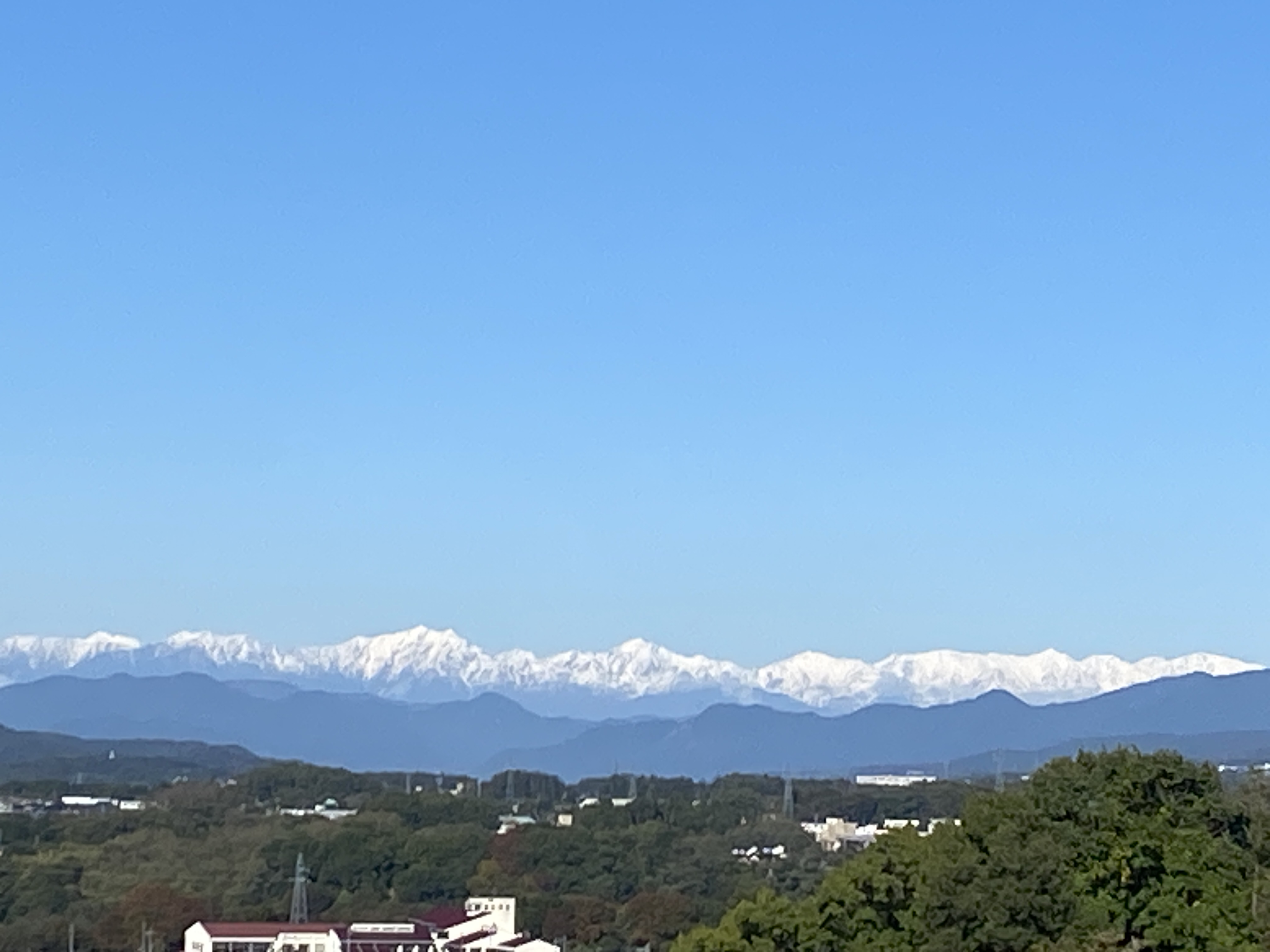
I wish the clouds didn't obscure these mountains. I just realized that I have climbed all but one of the mountains labeled. From the mountain on the far left, Tanzawa in Kanagawa, to the one on the far right, Asama in Nagano, is a distance of 118 km (73 miles). All the mountains on the left are my old stomping grounds--Kanagawa, Yamanashi and Tokyo. Now I live at the foot of Mt. Asama in Nagano.
I really need to put a dummy cord on these. Yesterday wasn't the first time I took them off at a break and walked away. Thank God they were still there when I went back.
(I do carry an extra pair, but I'd rather never need them!)
That marsh is called Goshikinuma. It literally means "5-color-marsh". I wonder if there is a better translation, though. It's not really 5-colored and I know other places with the same name.
The emergency hut below Mt. Shirane.
I thought this was a dumb idea. I think it borders on animal cruelty.
I guess that guy missed this sign down near the bottom.
The top was so crowded that I was limited to a closeup of the marker lest I capture other hikers in the image. It could be worse. Imagine what it's like to make it to the top of Everest and to have only a minute or two at the top because of other people waiting.
I took this from near the Goshikinuma.
Lunch. What could possibly taste better than leftover meatloaf on homemade bread in the mountains?
This is a very healthy granola I bought by mistake last week. I was at this place where athletes go to train at altitude and there was this vending machine full of all-natural protein/energy supplements. I saw this package and thought I recognized the character for deer and had to buy it. Well, when I got home and checked my Japanese-to-English dictionary, I realized that though the word I was looking at looks like deer (鹿), it is actually part of the kanji for ginseng root (高麗人参の根). Oops.
It was still yummy. And healthier than you'd expect. There are no "~ose"-type ingredients.
I took this from around Mt. Goshiki.
They put this alarm there for idiots like me who don't use bear bells.
Swing and a miss. Strike one.
"Beware:
Bird/boar/deer traps in the area"
Bus stop and some of the businesses around Yunomoto.
I dropped by an onsen. Unusual for me. Finding a mountain stream is more my style.
For any of you uninitiated barbarians, "onsen" is Japanese for hot spring. An onsen is where Japanese bathe communally in super-hot water. This is the path to the onsen.
When you go into the onsen, men and women separate into two different bathing areas and get cleaned up au naturel. Here's me inside:
Get your minds out of the gutters.
This is the actual hot spring bubbling up out of the ground. It smells like sulfur.
Each of the onsen (businesses) in the area has a hut like this covering its particular access point to the hot spring. I'm assuming there are pumps and pipes inside these huts.
My last stop of the day was to the Visitor's Center to get a Tozan Badge. (Commemorative pin. I buy one each time I climb one of the 100 Famous Mountains.)
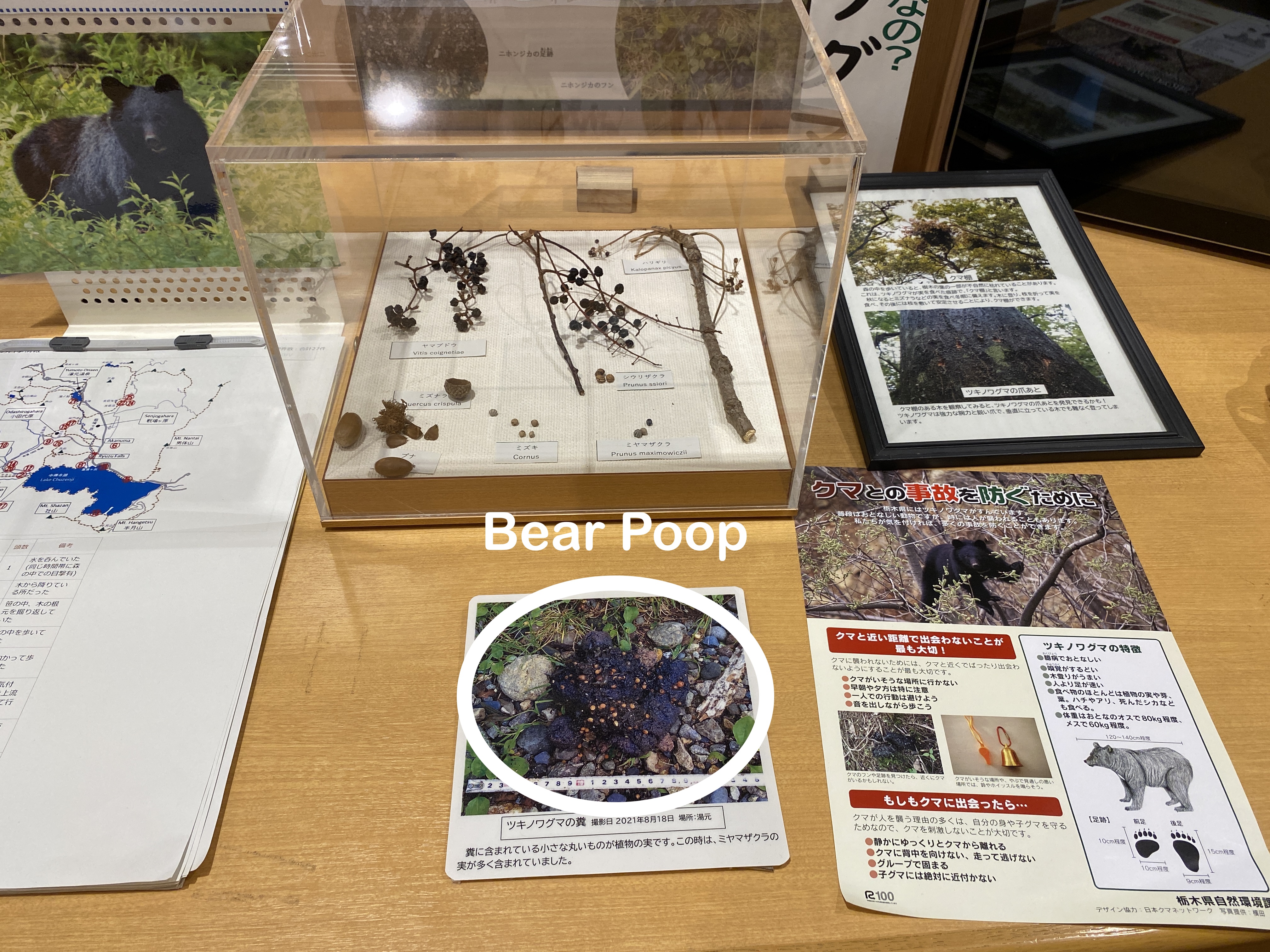
I was really impressed with this visitor's center. The Japanese tend to do everything well so it is easy to take competence for granted here--but this is the best visitor's center I've been in. When I told the staff, they proudly announced that this particular place was the first visitor's center in Japan. They have great displays. I was especially glad that had exhibitions of animal scat. 💩 Whenever I see poop on the trail, I wonder who left it there. Now I know. Thank you Yunomoto Visitor's Center. You've enriched my life.
I know who to blame (for pooping in my mancave.)
Deer poop
Other examples of poop
Japanese Flying Squirrel----Rabbit
Japanese Marten Mice
Bear poop
I wish I took a better picture of the lake. It is a nice spot.
Want to see another of the 100 Famous Mountains that is located in Tochigi?