Showing posts with label dayhike. Show all posts

Mt. Akiya, Shimonita, Gunma 秋葉山


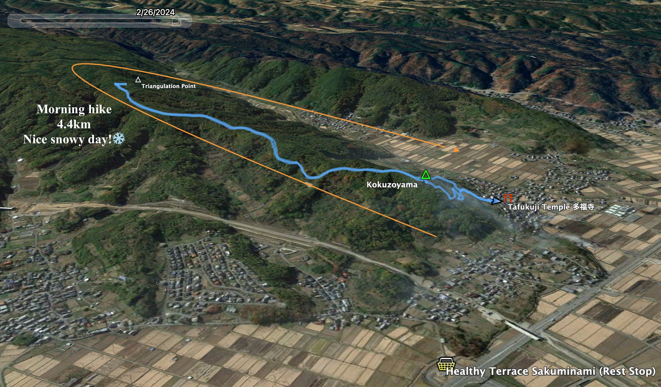
Location:  Shimonita, Gunma

Starting and stopping point:  Side of the road

Peaks bagged: Mt. Akiya (秋葉山)

(First-time) peaks #863

Getting there/getting around:  Car

Map:  Yama to Kogen Chizu #21 西上州 妙義山・荒船山

Weather Information: Mt. Arafune's weather (not too far away)

Total Time: 3:05   Break time: :13  Distance:  6.59km

Elevation:  Lowest: 456m Highest: 861m Total Ascent:  633m Total Descent: 639m

Technical considerations/difficulty:  Very steep.  I mean, very steep.  There is only one place with a rope; I wish there were more.  You don't want to make a misstep here.  I have no idea what the trail looks like in non-snow seasons, but there is very little signage and not so many pink ribbons to follow.  A working GPS is a must.

Facilities:  Nothing

Thoughts/observations/recommendations:  

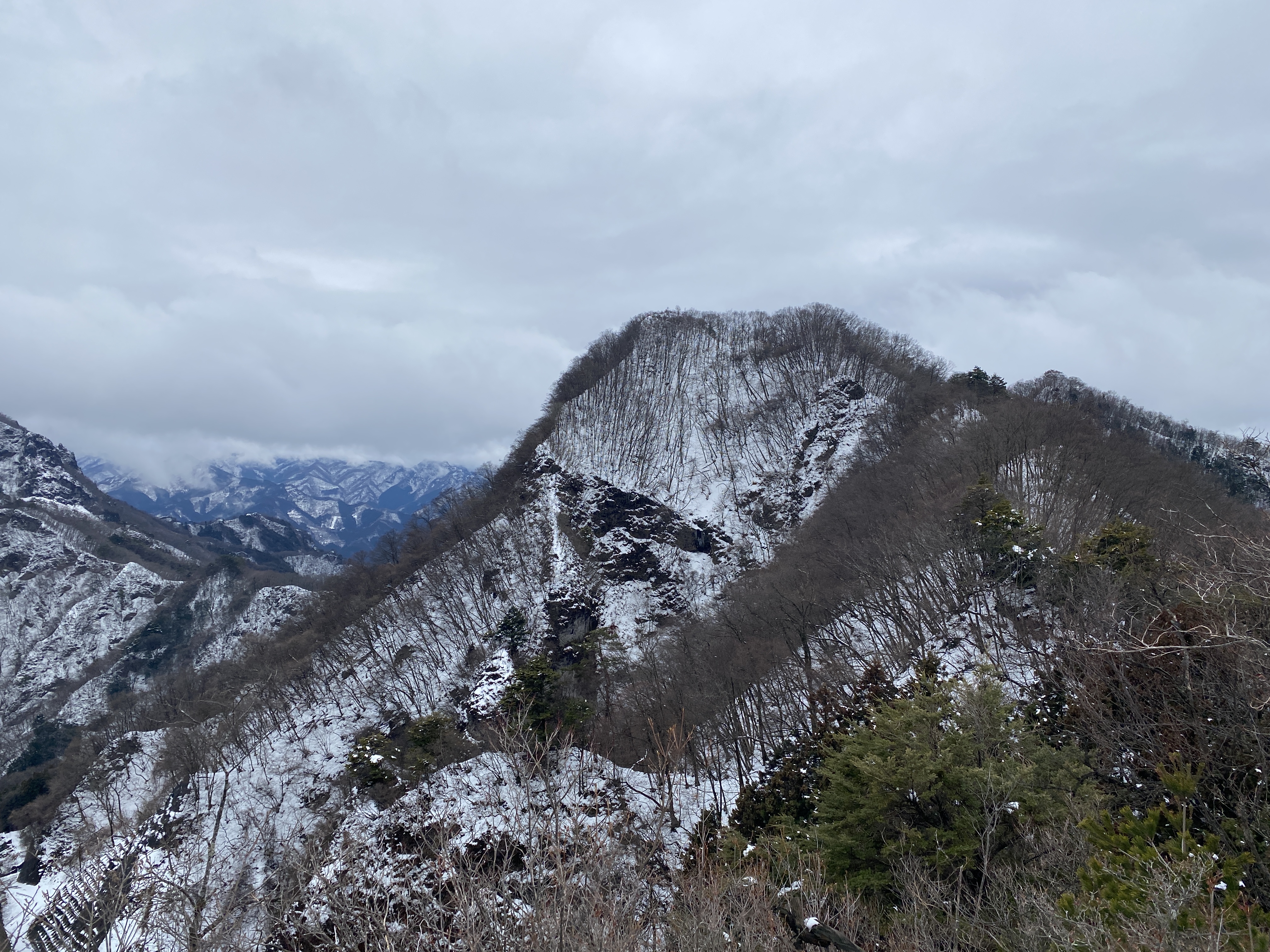
We got some snow last night and I got out of work early today so I picked one of my shorter hiking plans and headed to the hills in hopes of possibly using my snowshoes and also of catching some nice snowscapes.  I didn't use the snowshoes; crampons were more suitable today.  Unfortunately, it warmed up too much during the day and there was a lot of melting going on.  Thankfully, there wasn't an avalanche.

I had planned on this trip to tackle Mt. Akiya and nearby Goshuyama but prudence dictated putting the second mountain off for a day when I have more time available.  This area, like much of Gunma and a lot of Saitama demands a lot of respect.  There are a lot of  hills here that, although they are low in elevation, are very rugged.  It's not the type of place you can rush.

Still, I was glad to put a few more miles on my hiking boots today and to get some nice views of snowy mountains.  The caves here are cool, too!


Without further ado, here are some pictures.


There are a lot of caves on the way up.  Thankfully, they are home to shrines and statues and not bears.


The top


Mt. Akiya Shimonita, Gunma 秋葉山下仁田町群馬


Still on the top


Mt. Asama is hiding in the clouds there.


I wish it were minus 3 and not plus 3.


I got this shot of Mt. Arafune's Tomoiwa from Route 254 on the way home.


That's all for today.
Caveman out.


Mt. Arafune/Kyozuka

Location:  Saku City, Nagano and Minaminomaki, Gunma

Starting and stopping point:  (Near here) Arafunedoshita Parking Lot

Peaks bagged: Mt. Kyozuka

(First-time) peaks None

Getting there/getting around:  Car

Map:  Yama to Kogen Chizu #21 西上州 妙義山・荒船山

Weather Information: Mt. Arafune's weather (not too far away)

Total Time:   1:57 Break time: :04  Distance:  4.5km

Elevation:  Lowest: 1,017m Highest: 1,422m Total Ascent:  430m Total Descent: 430m

Technical considerations/difficulty:  There are some steep slopes off the side of the trail but there are no parts that are difficult to climb.  The signage is old and hard to read but if you pay attention, you shouldn't get lost.

Facilities:  Nothing.

Thoughts/observations/recommendations:  This hike doesn't have much to recommend for views.  Better views are to be had on the other end of Mt. Arafune at Tomonoiwa.

Speaking of "Mt. Arafune", the naming of this mountain is odd.  The peak I went to today is called "Mt. Arafune (Mt. Kyozuka)" and down the trail a little bit, at a much lower point, is "Mt. Arafune."  The mind boggles.  Why not choose one distinct name for each place?  I'm often puzzled by the names of mountains (and streets and towns and people . . . ) here. 


Today's listening: The Great Detectives Jeff Regan  Before Jack Webb was Joe Friday, he played a few private detectives in noir dramas.  Jeff Regan was one radio show.  He was also Pat Novak for hire.  Those shows are a hoot.  Some of the one-liners he delivers are so funny:  

  • “It was hard to figure. It was like trying to throw a saddle on a porpoise.”
  • “I had about as much chance as a snowball in a Turkish bath.”
  • “When she said, ‘Hello,’ it melted all over you, like honey on a hot biscuit.”
  • “He was crumpled up against the desk and she was staring down at him as if she forgot to water the plants.”

(h/t to this site https://thrillingdetective.com/2020/09/22/jeff-regan-2/)  


Today wasn't super-photogenic.  It was just a chance to get into the woods before work this morning.  Here are a few pictures.


The top


Well, kids.  That's all for today.
Caveman out.

ps  A conversation with the little woman I had yesterday.

Caveman:  I'm glad I have a blog.  I have a bad memory and want to remember where I have been.
Mrs. Caveman:  I'm glad you have a blog, too.  I can remember you when you're gone.

What does "when you're gone" mean?


Kokuzo in the snow. Too pretty not to share.


As often happens when I look out the window here, I felt drawn to the hills this morning.

There was a fresh coat of snow on the mountains all around and I couldn't not go for a quick hike before work.

This area I went to is characterized by a viewpoint on a small hill which faces Mt. Asama, the Takamine Kogen and Yunomaru Kogen across the valley which the Chikumagawa meanders through.  

One of the first things I did when we moved here was to run to that viewpoint from home and back--about 10km.

Since then, I've hiked there about 20 times because it's so convenient.  Since I go there so often, I don't usually blog about it but today it was just too pretty not to share some pictures.

If any of you have been through Saku, you may know the Michi no Eki (rest stop) called Healthy Terrace Sakuminami.  Mt. Kokuzo is right behind there.  You could hike up it in about 30 minutes from the Healthy Terrace.
I usually start at the Tafuku Temple.

I don't stop at the viewpoint either.  I typically go as far as a certain triangulation point further up the trail.


I was on Kengamine a week or so ago.


I was on Yunomaru two days before.


That's all.

Caveman out.