Elevation:Lowest: 1,017m Highest: 1,422m Total Ascent: 430m Total Descent: 430m
Technical considerations/difficulty: There are some steep slopes off the side of the trail but there are no parts that are difficult to climb. The signage is old and hard to read but if you pay attention, you shouldn't get lost.
Facilities: Nothing.
Thoughts/observations/recommendations: This hike doesn't have much to recommend for views. Better views are to be had on the other end of Mt. Arafune at Tomonoiwa.
Speaking of "Mt. Arafune", the naming of this mountain is odd. The peak I went to today is called "Mt. Arafune (Mt. Kyozuka)" and down the trail a little bit, at a much lower point, is "Mt. Arafune." The mind boggles. Why not choose one distinct name for each place? I'm often puzzled by the names of mountains (and streets and towns and people . . . ) here.
Today's listening: The Great Detectives Jeff ReganBefore Jack Webb was Joe Friday, he played a few private detectives in noir dramas. Jeff Regan was one radio show. He was also Pat Novak for hire. Those shows are a hoot. Some of the one-liners he delivers are so funny:
“It was hard to figure. It was like trying to throw a saddle on a porpoise.”
“I had about as much chance as a snowball in a Turkish bath.”
“When she said, ‘Hello,’ it melted all over you, like honey on a hot biscuit.”
“He was crumpled up against the desk and she was staring down at him as if she forgot to water the plants.”
(h/t to this site https://thrillingdetective.com/2020/09/22/jeff-regan-2/)
Today wasn't super-photogenic. It was just a chance to get into the woods before work this morning. Here are a few pictures.
The top
Well, kids. That's all for today.
Caveman out.
ps A conversation with the little woman I had yesterday.
Caveman: I'm glad I have a blog. I have a bad memory and want to remember where I have been.
Mrs. Caveman: I'm glad you have a blog, too. I can remember you when you're gone.
Getting there/getting around: I drove. It's a narrow, winding road off of the Cosmos Road. If my name were Paul, I might say it's a Long and Winding Road.
Elevation:Lowest: 1,037m Highest: 1,350m Total Ascent: 453m Total Descent: 453m
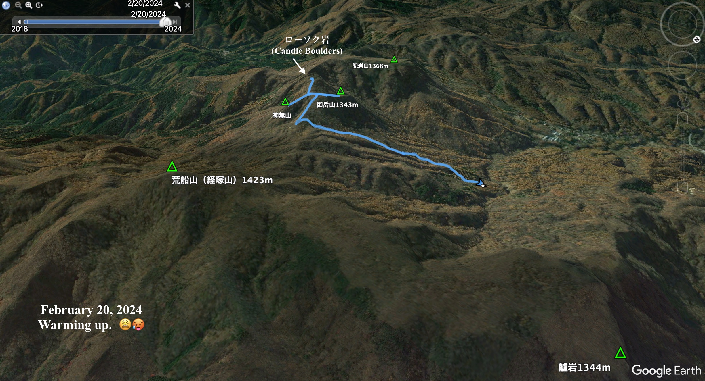
Technical considerations/difficulty: These hills are not really high but demand your full attention. The ridgeline is as sharp as a knife in places and the ridge falls away steeply on both sides. There are a few spots with chains or ropes. I was hiking after most of the snow had melted so there was quite a bit of mud. That made for slipperier conditions than if it were snow-covered because I couldn't make use of crampons. If conditions were better, I probably would have gone just a bit farther to be able to see the Rosoku Iwa from all sides but decided it wasn't worth it. At that point, the trail was in the shade and covered with snow. The trail there was quite narrow and just hugged the side of a really steep hill.
The Rosoku Iwa(s) themselves are not really for hiking. The trail passes around them but getting to the top of two of them entails actual rock climbing and necessitates all the equipment incumbent on that kind of adventure.
Facilities: Nothing. You may be able to get some water from the stream, but there's nothing up there.
Thoughts/observations/recommendations: Like I said, I'm glad I ignored the weatherman. If I had slept in today and then walked out into the sunny morning that it turned out to be, I would have been bummed out.
This was my 3rd or 4th time to this area. Sometime soon I will have to get to the nearby 立岩(Tateiwa) "Standing"--"Boulder".
I'm so bummed out the snow is melting so quickly around here. I'm going to have to drive a bit far to get to snow.
Here are some pictures:
This is just before the peak of Mt. Ontake. I'm sure many people mistake it for the peak.
Mt. Asama is in the distance in the middle of the picture.
Rosoku Iwa is actually 3 places named P1, P2 and P3.
P stands for peak. h/t to Naresh Deora.
This is P1.
This is P1.
I could climb to the top of this one.
I didn't even realize that I had climbed P1 until I saw a picture of it on another blog.
It was a bit dizzying and climbing off
of it was a little unnerving.
I was on that one on the left, Kabuto no Iwa, a few weeks ago.
I got as far as just beneath P3 and turned back.
The trail was pretty slippery--(and I was already in
danger of being late for work. Shhhh.)
I'm grateful for the chain.
Pictures can't quite capture how narrow and how high this ridge is.
Saitama's Mt. Ryokami is in the distance.
Well, that's it for today. The last pictures are pics with mountain names labeled on them in case
any of you are geeks like me with an interest in knowing the names of mountains.
If not, you can stop reading now.
Subscribe. Tell your friends, etc.
Or not.
You do you and the caveman will do the caveman. (Hey, I think
I just came up with the name of the next new dance--The Caveman! It'll be bigger than the
Total Time: 1:13 Break time: 3 Distance: 6.8km (4.25m)
Elevation:Lowest: 1,113m Highest: 1,373m Total Ascent: 373m Total Descent: 373m
Technical considerations/difficulty: A lot of this is runnable.
Facilities: My run brought me past a campground twice. I suppose there maybe water there. There is a public restroom. I'm not sure if they close in the winter. I just checked and they are taking reservations until December 31. I'm not sure if they close then or if they just aren't taking reservations that far out. Arafune Panorama Campfield
Thoughts/observations/recommendations: This was a great run. It enabled me to connect the dots of my footprints a bit. Even though it was just a short time, running at the golden hour under clear skies gave me better views than I've had on several long excursions lately.
I won't write too much. I've already spent more time on this blog post than I spent in the woods!
Like I said, much of this is runnable.
One of the many great views of Mt. Arafune.
There is a pasture full of cows. I wondered how they kept the cows safe from bears. I did notice that the pasture is surrounded with barbed wire.
Coming down off Monomi, I ran on pavement for a while. Deer love these type of roads, especially at this time of day.
Mrs. Caveman and I first came to this area to look at the field of cosmos a few weeks ago. They're all gone now.
I love this sign! It is actually oriented to what it overlooks.
One of my pet peeves is that signs like this in Japan are often not oriented to the direction they are pointing. You have to twist your head around and try to do geometry in your imagination to reconcile the map with what you are seeing on the ground.
Well done Saku City for this sign!
This song is played in this town over loudspeakers at 5:00 pm every day. I think every town in Japan plays something near the end of the day to signify the time. It's not at 5 everywhere and some municipalities play different songs.
This song is called Yuyake Koyake 夕焼け小焼け. Yuyake expresses the idea of the last bright sunlight before the sun goes down and koyake is the light that remains just after sunset. It's quite nostalgic for me. The first town I lived in in Japan played this song at the end of the day. Doing some research for this blog post revealed that the lyricist was from Hachioji. Not only that, but I also realized that a place I hiked through before (on a long hike from Musashi Itsukaichi to Takao, 26 km) was named Yuyake Koyake Fureai no Sato in his honor because it's near his birthplace.
I really love this song and it was poignant to hear this here at this time of day.
Well, that's enough for now.
If you liked this place at sunset, check it out at sunrise here


.JPG)


