Japan's second and fourth highest mountains. Kitadake and Ainodake. October 3 and 4, 2021

Here comes the sun!  I was so happy to be blessed with nice weather for a camping trip up in the higher elevations.  It really has seemed like forever since I had a clear day to enjoy the views.  Thankfully, my patience (and a lot of hard work on this trip) was rewarded with some stunning sights.


See, it really was gorgeous.


This trip was a bit farther than I usually go and incorporated mountains I usually only glimpse from a distance.  Usually, I travel within a radius that I can get to on my scooter or bicycle for a day trip.  I wanted to go somewhere higher for this overnight so headed out to the Minami (Southern) Alps.  My goals were to climb the 2nd and the 4th highest mountains in Japan; Mt. Kitadake and Mt. Ainodake.  

This entailed taking a train (the Azusa Express on the Chuo Line) from Tachikawa to Kofu and from there a two-hour bus ride up to the Hirogawahara Sanso where the trail starts.  I left my home about 7 am and was at the trailhead about 11.  The Hirogawahara trailhead is at the top of this map.

Kitadake trip map 北岳と間ノ岳地図


It was a day of new beginnings.  My faithful and trusty boots started to show some wear and tear over the late summer.  I bought a replacement pair in August but determined to wear the old ones until my feet bled.  On my last hike, though, a big rip appeared in one of the seams and, rather than getting them repaired (again), I decided to use the new ones.  

Hail and farewell.


This was a steep hike.  It's an ascent of about 1,700 meters from Hirogawara to the top of Kitadake.  That's more than a mile for any Americans who are wondering.  And that is not taking into account any of the up and down portions along the way.  After hiking for about an hour, for some reason, the thought occurred to me that the highest point in Tokyo is 2,017 meters and I wondered how high I was at that point in time.  When I checked my map, I happened to be at an elevation of 2,018 meters.  That seemed kind of cool to me.  


I noticed that the leaves had started to change colors around 2,200 meters up.  Getting higher, I was getting treated to lots of great scenery.


One thing that made this hike challenging was that there were no breaks in the climbing.  Usually, when you get up to a ridge, you get some rest and things flatten out in places.  Not here.  The boulders keep you on your toes.


Between the starting point at Hirogawara and the furthest point, Ainodake, there were two places that I considered for pitching my tent.  The first is a place called Katakoya (肩小屋), which is before Mt. Kitadake.  The second place is on the far side of Mt. Kitadake, called Kitadake Sanso (北岳山荘).  Tentatively I planned on making Kitadake Sanso on day 1.  I was thinking of getting up before sunrise on day 2 and heading up to Ainodake for sunrise before returning to retrieve my tent on the way back down to the bus.

But . . . I got a little worried when I realized I wasn't going to be able to start until 11 on day 1.  Also, the time estimates on different maps varied widely and if some of them were to be believed, I wouldn't have gotten there until long after dark.  Usually, I'm faster than those estimates but sometimes they are spot on.

I reached the first option, the Katakoya, around 3 after 4 long, hard hours of work and decided I'd had enough for the day.  This hike, from beginning to end, was a bear.  Most of it is steep and a lot of it is hand over hand.  I was averaging about 1 km/hour.  Walking on flat ground, I walk 1 km in about 12 minutes.  Hiking in hills, I usually do a km in about 20 minutes.

Anyway, fatigue got the better of me and I stayed there at the first place.  Looking back, I probably could have made the second place but I think I did make the right decision.  Prudence is the better part of valor.  


This is me ringing the bell announcing my arrival at the Katakoya.  :-)


Here's my tent.

The rock was to keep it from blowing away until I got it set up and put my junk inside.  It was windy.


Tenting here is ¥1,000.  Staying inside the lodge is (I think) ¥9,500.  They have food.  It's pricey as you would expect since all the supplies are brought by helicopter.  Bottled drinks are ¥600.  Chips, too.  I think a bottle of wine was ¥2,800.  I'm glad I don't drink!  They will let you refill your own water containers for ¥100/liter.  That's a bargain.

I got my tent set up and choked down some chili for dinner.  I was surprised to not be very hungry.  I was starting to feel like I had a cold.  I had, basically, a miserable night.  My head was pounding.  I was sneezing.  I couldn't sleep.  Every time the breeze tickled the flaps on my tent, I thought it was a raccoon after my trail mix.  

As sometimes happens in my tent at night I began wondering about some life decisions.  "Is this really fun?  Do I really want to go all the way to Ainodake tomorrow?  I'm only 1/3 of the way through this trip and I'm this beat.  What if these symptoms are COVID?  Are they going to let me on the bus back to Hirogawahara?  That's the only way to civilization..."

Sunrise was at 5:42 so I set my alarm for 5:30.  I didn't need any alarm.  I gave up any pretense of trying to sleep and opened my tent flap at 5 to see this.

sunrise from Kitadake 北岳の夜明け

And everything was right in the world again.  I was so happy I was on this trip.


I took far more pictures of the sunrise than you are interested in seeing, but it was spectacular.  And worth all my murmuring to myself overnight.  Here are just a few.


北岳 Kitadake Sunrise


This video is long.  I don't even have the patience to watch the whole thing.


After breakfast and tearing down the tent, I started off at about 6 or 6:30.  I was at the top of Kitadake after 7.


Mt. Kitadake


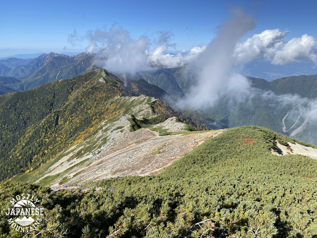
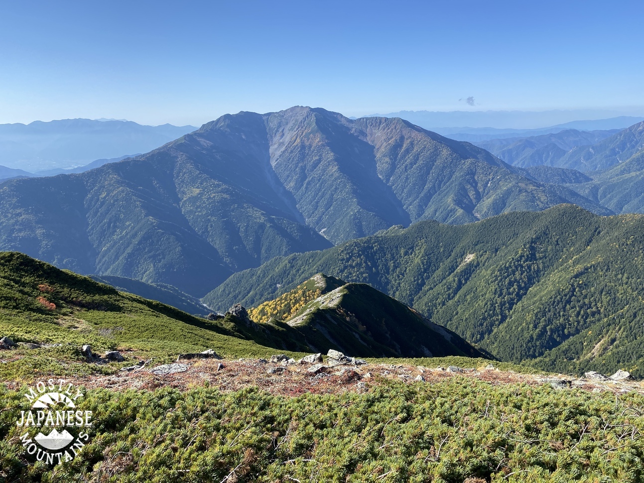
Then I trucked on down to the Kitadake Sanso and up to an interim peak, Mt. Nakashirane, before heading on to Ainodake.


The Kitadake Sanso is about halfway up the first hill a bit to the left of the ridge in this picture.  That first hill is Mt. Nakashirane and the taller one beyond that one is Ainodake.


This is from Mt. Nakashirane.  So many mountains are on my bucket list now.


This is Mt. Ainodake.

Mt. Ainodake 間ノ岳


Panorama from Mt. Ainodake


This was taken from the Kitadake Sanso.  Those mountains notated on the right side are my usual stomping ground; 30-40 miles to the east.

Kitadake Sanso 北岳山荘


No rest for the weary.  Going down was a challenge, too.  LOTS of steep stairs.  Lots and lots of scree.   That makes for frustratingly slow-going and is a bit treacherous.  


You know, one thing struck me about the beauty and awesomeness of nature on this trip.  That is that the same Creator that made all of this beautiful stuff also made you and me--and how amazing it is that you and I are more valuable and beautiful even than all the most wondrous things in nature.

And we will outlast them.

Psalm 46


Come back to the cave again sometime.


Here's one last video--an animation of the route--if you're interested.


Caveman out


What's in my pack?

Everyone's always asking me what's in my backpack.  Usually, they say something like, "What have you got in there, a Sherpa?" 

I'll put some pictures up of what I carry on day trips between spring and fall.

My pack is pretty much always ready to go.  I just need to do replenish food and water for each trip.


I tend to bring probably more water than I need.  Even if there is a water hole on the map, I would rather have more water than not enough.  I don't go in for expensive water bags or anything like that.  As you can see, I'm recycling plastic bottles  I usually drink one bottle of green tea each day and I keep the leftover bottles for hiking.


I usually bring a thermos with some coffee, too.  


This is enough food for a full day of hiking.  

I've been baking bread since COVID started and I typically take a sandwich made with homemade bread.  On this day I opted for banana muffins instead.  Wow, they were good.  That green case is pretty sturdy.  It used to contain a camping stove but I like to use it to keep crushable food items safe.

The trail mix is usually some combination of raisins or dates, peanuts or cashews and M' and M's.  If you're in Japan, I would recommend looking for peanuts at Don Quijote and other nuts and raisins at Gyomu Supa (業務スーパー).  They have the best prices.  

I like to hike with apples because they are portable and I don't feel like I have to pack out the core when I am done eating.  It goes back to nature.  


You might notice there is no cooking stuff in my pack.  Good eye.  I don't see the need to carry all that extra stuff on a day trip.  If I want something hot, I'll heat it at home and bring it in a thermos.  I'll be honest, when I see people pulling out a camping stove for a trip to a local mountain like, say Takao or Hinode, I think to myself, "amateurs".  Haha.


Sometimes necessary...


My iphone would run out without a battery pack.  You may be asking why I have two cords.  I was hiking with the battery pack in one pocket and my smartphone in another pocket when I snagged the on a tree one time and it broke.  That's why I have two.  


One of the nicest purchases I ever made.  I don't think I'm very materialistic, but there are a few possessions I have that I really like.  These bins are one of them.


Rarely touched...but always in the pack just in case.


I still have two headlamps in my pack from climbing Mt. Fuji with my son this summer.  
The green pair is better.  BUT, if I leave the batteries in them, they will drain because they tend to get turned on as they get bounced around in the backpack.


Just in case . . .


Something like first aid.  In the winter I will augment this stuff with some vaseline for my lips.


Thankfully, still haven't needed them.


Because knives are cool.


Never touched.  It's just in case.


I always have a paper map and a compass.  To be honest, I almost never look at them because navigating in the dense terrain of Japan is different than navigating elsewhere.  There are so many switchbacks on the trails that using a compass to go in a straight line is out of the question.  The micro terrain here is so extreme here that the details just cannot be covered on a paper map.  I hate to say it, but I rely an awful lot on my iphone for navigating.

That said, I do use the paper map and the compass when I'm at a vantage point where I can see a few miles to identify the mountains nearby.  

(I haven't forgotten how to be an infantryman either.  If my iphone died, I would not be lost!)

This map is a Yama to Kogen map (山と高原地図).  There are Yama to Kogen maps for all over Japan.  They have a lot of details useful for hiking.  Hiking trails, average course times, bus routes, bus company contact information, lodging information, etc.


The Yama to Kogen maps are sold online or in bookstores and come in boxes like these.  Along with the map, there is a small booklet with information about the area.  The Yama to Kogen maps are also available as smartphone apps.


I started carrying this after a particularly bloody and gross hike up Tanzawa in August.  Ewww.


Awright, that's what is in my go-bag.  I weighed this and it was about 9kg.  I was surprised.  It doesn't feel that heavy to carry.


Where is the sun?


Yesterday I took another in a seemingly endless string of nearly viewless hikes.  The Sasa Ridge runs a little over 10 miles (about 18km) more or less northwest to southeast from Mt Mito on the Yamanashi and Tokyo border down toward Mt. Jinba in Kanagawa.  There are trails up to the ridge from Route 18 in Uenohara City, Yamanashi on the south side and from Hinohara Kaido on the north side from Tokyo.  


I really like to make connections when I hike.  I don't want to merely hit every mountain, I want to hit every trail to every mountain.  A few years ago, I concentrated on the Sasa Ridge for a good 2 months and hiked just about each one of the access trails.  Trails I've hiked are traced in red.  The brighter the lines, the more recent the hike.


Yesterday's hike was from Fujio in Uenohara up to Fuefuki Pass on the Sasa Ridge, over to Mt. Maru and then all the way up to Mt. Makiyose before backtracking on the ridge again to one of the trails down to Route 18 in the Tawa area.  To date, I have now climbed Mt. Maru 5 times and Mt. Makiyose 7 times.  In all of these hikes, I have yet to have a clear day.  Haha.  It is a bit unfortunate because this ridge faces the Tanzawa Mountains, Mt. Fuji and some of the Minami Alps.

Someday I'll see something.


n.b. Peakvisor in this picture calls this Maki Yadoriki.  It's wrong.  It's Makiyose.
槇寄山  Mt. Makiyose


The best views I got all day were in the locals' gardens.


No idea what is up with this guy.  I saw this on the street.  I don't know if it's indigenous or if it escaped someone's kitchen.  It's much smaller than it looks.  Maybe 1 inch (2.5cm) across. 


More later.  I will keep hiking until it clears up!  It has to clear up someday.