If there's anything in the world I hate, it's leeches. Filthy little devils. Charlie Allnut
I'm with Mr. Bogart on this one.
Greeting cave critters.
I went to Kanagawa yesterday to take a different trail up to Mt. Tanzawa. It was a really great day--except for the leeches.
That was the least gross picture I got of leeches yesterday. If you want to see some more gruesome ones, let me know. I try to concentrate on beautiful stuff on this blog so I thought it better to spare you the icky stuff.
One of the irritating things about leeches is that they inject an anticoagulant into the wound so that the blood will just keep pouring out for hours if you don't stop it.
I've been up Mt. Tanzawa 3 or 4 times. It's a nice area to hike in. The views from the top are ok, but the views on the way up tend to be even better. Although it was a beautiful day yesterday, the top was surrounded by mist and clouds and I didn't take any pictures up there.
On this trek, I assaulted the mountain from the east, a trail I'd yet to tread. It was a fairly steady climb. I started at an elevation of around 300 meters and Tanzawa is 1,567. I realized later that the distance of this hike was greater than the hike I did up Fuji last week. And, taking into consideration the up and down nature of this hike, the change in elevation also was greater on this hike.
Shrooms!
This little guy was no bigger than a quarter.
I started by Lake Miyagase, a sight I'd yet to see. It's a nice-looking lake. It seems quite popular with bicycles and motorcycles. It turns out that that was the most photogenic part of the journey.
Time to soak the barking, and bleeding, dogs.
Drop by the cave again sometime. I'm happy you came by.
Want to see another of the 100 Famous Mountains? Kobushigatake Or more of the Tanzawa area? Tanzawa Area
One of the 100 Famous Mountains of Japan is Mt Ryokami (両神), in Saitama. I climbed it once a year or two ago but I promised myself I would try to go again even though it's quite far from me for two reasons. First, it was cloudy and I didn't see anything the first time. Second, I wasn't able to buy a memorial badge. I try to buy one of these mementos whenever I climb one of the 100 Famous Mountains.
This is the badge for Ryokami. I received it yesterday.
I tried climbing Ryokami once more from a different trail last year but turned back before even getting near the mountain. My map recon was insufficient and I found my chosen path more resembled a rock-climbing expedition than a hike. That trail was littered with chain-less, ladder-less vertical rock faces and was not marked. At more than a few spots you had no idea what was waiting on the other side of the corner that you were going around. The trail might be there or it might be a 1,000 foot drop. No way of knowing without going ahead. Not having a sherpa or even any ropes, I decided to, as the Japanese say, "Have the courage to go back." ("Courage" my butt. Let's call it prudence or common sense but let's not call turning back courage.)
D"#$ you, Ryokami. I had to have my revenge.
This time I chose to start at a parking lot called Shiroizasu (白井差). My map recon was insufficient this time, too. When I got to the parking lot, I found out you are supposed to call ahead and make a reservation. The trail is on private land. This information is printed on paper maps but I had done my planning online and that information isn't online. Anyway, when I got to the parking lot, I was confronted with a sign saying it's private property, you need to make a reservation by phone in advance, parking and use of the trail costs ¥1,000, etc. The owner turns out to be the guy who actually built and still maintains the trail that starts at the parking lot. He was an interesting character. He gave me a laminated map and very detailed instructions about every inch of the trail. I asked him if he knew where I could get a badge. He said he would happily give me one--when I came back. I asked him where to pay the ¥1,000. He told me to pay him--when I came back safely. If I didn't make it down safely, parking and use of the trail would be free.
What a bargain!
He was an interesting guy. Along the trail, he had left tools and equipment here and there; chain saws, gasoline, rakes, bug spray, that he must use for trail maintenance. When I came down, I told him how impressed I was with all of the ladders, chains, and even concrete on the trail. "How'd you get all that stuff up there? Helicopter?" He said that now they would use helicopters but when he put all that stuff up there 25 years ago, he packed it all on his back. "Your back gets used to it." Very impressive.
The trail from Shiroizasu is shorter than either trail I tried before. The first quarter of this trail crisscrosses a stream and passes some falls. I like that.
Here are some random pics of the day. It wasn't a perfectly clear day but it was better than last time. And I got the badge.
In this area, there are a lot of spots with chains like this. I was going to go to the third peak after Mt Ryokami but the old guy at Shiroizasu told me there are about 20 spots like this between the 2nd and 3rd peaks. I decided to stop at the second peak. One set of chains is exhilarating. Two is worrying. Three is tiring. Twenty is something I don't want to contemplate.
This sign appears after the second peak.
"CAUTION Hachou Pass Course
This course has a lot of chains, boulders, etc.
NOT FOR BEGINNERS..."
They aren't kidding.
When I left the mountain, I dropped by the Marukami Falls (丸神ノ滝), a 20 minute walk off the road.
And of course, I found a swimming hole to give my barking dogs a break.
So pumped to make it to Fuji the other day with my son. This trip is something I've been looking forward to for two years. In 2019, some friends and I had an attempt at Fuji thwarted by weather at the 7th Station. Last year, I couldn't get my revenge on the mountain because it was closed down by COVID.
This year, I was diagnosed with cancer and I was absolutely determined to do Fuji during this season no matter what. (Thankfully, my cancer was taken care of with a couple surgeries. Yay!)
Fuji, having its reputation for being Fuji, made it difficult to find a climbing partner. They do say, "A wise man climbs Fuji once, a fool climbs it twice. "
I don't blame my friends. I swore that I would never do it again after my first ascent about 25 years ago. On that trip, I was beyond miserable. I had a headache, muscle aches, heartache. It was awful.
It was to be expected. I was smoking 2 packs of Marlboros a day. Exercise was walking to McDonald's.
Anyway, my 15-year-old son stepped up to the bat and said he'd come with me. What a gift. Thankfully, he's a jock and I didn't have concerns about his physical condition.
I took something like 360 pictures up there. It's so beautiful and is really difficult to pare down to the best so this post is picture-heavy. I hope they aren't boring for the reader. I always say less is more, but I am kind of like Polonius. (He's the guy who said, "as brevity is soul of wit, I shall be brief"--and then proceeded to talk until the audience nearly fell asleep.)
Before putting up the play-by-play, let me put up some details
Location: The big daddy of Japan, Mt. Fuji
Starting and stopping point:
Akishima, Tokyo/Fuji Subaru Line 5th Station
Peaks bagged:
経ヶ岳 ~ 久須志岳 ~ 成就岳 ~ 伊豆岳 ~ 朝日岳 ~ 三島岳 ~ 富士山(剣ヶ峰)
(First-time) peaks # ----
Getting there/getting around:
There are several ways to get to Fuji. Depending on the hiking route you take and the time of day you opt to go, you'll need to assess whether a car or some combination of train and bus work best for your plan. For most people coming from Tokyo, the Yoshida Route in Yamanashi is the easiest to get to and you can get to it by highway bus to Kawaguchiko Station, and from there taking a shuttle bus to the 5th Station.
Lowest: 2,274 mHighest:3,776 mTotal Ascent:1,720 mTotal Descent:1,714 m
Stuff to think about
Technical considerations/difficulty:
Fuji is truly wonderful. You must be prepared, though. Altitude sickness hits many. Many people who are out of shape and ill-equipped go to Fuji and put themselves and others in danger. At the minimum, they cause themselves to suffer.
It's not that difficult technically or physically on the average summer day. There are many areas with chains or ladders. but there is no place that you need to wear a harness or do any free-climbing. It's steep, but the longest of the usual trails is still under 10 miles. That's not much more than the average day-hike for someone who is often in the woods. When I lived in Tokyo, I was surprised to realize that it was possible to climb it Fuji a day--and get home for a late supper!
The last time I climbed Fuji, I was disappointed to see many un-prepared families. I saw a lot of parents carrying toddlers and many grammar-school-aged kids whining on the side of the trail while their parents yelled at them to get going. There were also families where the kids were fine. (I even saw a hiking club of 7-8 year-olds going all the way to the top. Those kids were amazing! No whining. All smiles.) Please, know your kids' limits if you bring them.
Wear the right clothes. Although Tokyo may be in the 30s (90s in fahrenheit), the top of Fuji at sunrise is near freezing.
***IMPORTANT INFO HERE*** There have been too many hikers in the past year or two and the Japanese are placing restrictions on the times you can hike and on the numbers allowed on the mountain. They are not allowing people to "bullet" (straight up and back without stopping) overnight. If you want to see the sunrise, you'll have to make a reservation and stay in a hut. After 4:00 pm, they won't let you on the trail unless you have a reservation. They are limiting the number of climbers to 4,000/day also. This website has all the information. Please see it for detailed explanations. Official Fuji Site
Facilities:
There are facilities all over the place--but they were a bit overwhelmed in 2023. Bring money for the pay toilets. There are lots of snacks/meals/drinks to be had on the mountain. Just remember that the higher you go, the more the prices rise.
Sunrise is really wonderful on Fuji. Many people start in the late afternoon and stay at one of the mountain huts for a few hours at one of the mountain huts before making the final assault. This enables your body to get acclimated and lessens the chance of getting altitude sickness. For this trip, I stayed at the Taishikan (Fat Child) Mountain Hut.
Thoughts/observations/recommendations:
I am so blessed to have been able to climb fuji and it environs so much. I hope you can do it, too!
Now, back to the original post.
New video here
7:00am August 1
Pointing at Fuji from home. (Really)
Remember that stick. It's important later.
This picture is the Fifth Station of the Subaru Line. All the trails waystations are numbered. Most people start hiking at the 5th Stations. Most of the trails have 8 stations before the top. One has 9. This is a very busy place. The Subaru Line is the most popular trail and this place can accommodate more tourists than you can imagine. The higher stations are nothing like this. Usually not much more than a shack chained to the mountain with rocks on top to keep the roof from blowing away.
The suggestion is to hang out here to get a bit acclimated to the elevation before proceeding. We left here at 11:30. It was suggested we get to our lodgings at the 8th Station by 4 or 5 and we were told it should take 4 or 5 hours to get there. (We made it there by 2.)
The route:
The weather was kind of unsettled on the way up on the first day so I didn't get too many good pictures. If the clouds opened up for even a second I whipped out my iphone.
This is where we stayed, the Taishikan. ("kan" means something like hall. "Taishi" was the name of an emperor or prince that was said to have rested his horse at this spot on his way up Mt Fuji in ancient times. If I were the horse and I had seen what was coming next, I would just have refused to go on.)
Interestingly, at 3,100 meters, it is already higher than the second-highest mountain in Japan which is a mere 3, 050 meters in elevation.
These mountain lodges are places where people rest for a while before making the assault on the summit for the sunrise.
Here are some pics of the interior. (Make sure not to miss my videos of the restrooms. Those are a hoot.)
In the past, everyone slept in a huge room. Now because of COVID, it's kind of like a rustic capsule hotel. I banged my head every time I got up.
A traditional irori. I read somewhere that the Taishikan is still using a pot from the 17th or 18th century.
Remember the stick from the first picture? You don't? Then maybe you have CRS or ADHD or, you might be POTUS.
Anyway, the walking sticks are a great money-making scam for the tourist businesses. As you go by the different lodges, they will brand them for you with that place's particular stamp for ¥500. Here I am getting mine branded by one of the staff at the Taishikan. (I say it's a scam, but I like having the stamp.)
Make sure you check out the video and its explanation, too!
After dinner (curry, at 4pm), we tried to rest. I was able to get an hour's worth of sleep I guess. My poor son, who hasn't had the chance to develop the skills I did in the military didn't get any sleep.
We got up around 1am and headed off for the top. It was a little earlier than necessary, but we had nothing else to do.
We got to the top around 3:30. There was no one there. Pitch black. We had nothing to do but pick our spot to wait for the sunrise.
Seeing how Tokyo is in the 90s these days, the top was a bit cold for us at about 3 C (38 F). It was worth it. What a show. I am also glad we were able to pick our spot. By the time the sun came up, it was nearly standing room only.
Again, make sure to check out the video. Hear authentic Japanese people really say "Banzai!"
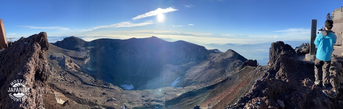
After shivering for nearly two hours waiting for the sunrise, we were ready to move within about a minute of the appearance of that sublime disc. Then we took a walk around the caldera.
Looking south toward Gotenba. That black bump is Mt. Hoei. I was able to climb that on my last trip in 2019.
(2019)
The route we took that year.
(Back to this year.) We got around to the top a little before 6.
I am so proud of my son. He hiked the highest mountain in Japan on no sleep in new boots and didn't complain once.
I got such a kick out of this. I wonder if real estate that falls within the shadow is cheaper.
I hope you enjoyed that. I know I did. I need to stop blogging now and get packed for tomorrow's hike.