Post-COVID saw tourism explode in Japan. Last year saw record numbers of climbers of Mt. Fuji which caused lots of problems. Public restrooms were overwhelmed. Too many people left trash on the mountain. Injuries of unprepared climbers strained the patience and the resources of the local authorities and service industry.
Despite new restrictions put in replace in response to the situation, this year's hiking season started off tragically. This video doesn't mention it, but 5 people died within just the first week or so of the climbing season.
Fuji shouldn't cost you your life. Just be prepared. And be ready to skip it or turn around in case of inclement weather.
I was lucky to be living in fairly close proximity to Fuji during COVID. I had the mountain almost all to myself some days.
I was playing with some old pictures the other day and realized that they really deserved video treatment.
Check out the original blogpost here, if you like. If you plan on climbing Fuji this year, you really need to know some new information I shared in the updated version.
Greetings cave visitors. Thank you for dropping by.
I was casting about for a few days trying to decide where to go for a hike. I had a few conditions that I wanted to meet for this hike so it was a bit difficult to choose. I eventually settled on two mountains on the side of Mt. Fuji. Perhaps you know Mt. Hoei 宝永山? That's the bump sticking out on the left side of Fuji when viewed from Tokyo. The two mountains I headed for are just below that. They are usually called some variation of Futatsuka or Futago. Futago means twin.
Mt. Futatsuka in winter
Without further ado, here are the stats and such. Then I'll show some pictures.
Most people take a car or a bus to one of the main parking lots. I took my scooter and parked on the side of the road. In my case, it was a great idea. It's not a spot you could put a car, though. I wouldn't risk putting a large motorcycle there either.
My actual plan was to take my bike to the Gotenba Train Station and take a bus up into the mountains from there. The reason was that I was worried about riding my two-wheeler too far up into the mountains. On the day, though, the weather and road conditions were just so nice that I decided to ride up as far into the mountains as I could and decide whether or not I needed to go back and get the bus. It turned out that I was able to get a fair distance up the Fuji Skyline Drive--not as far as the bus would have brought me-but far enough. It seemed like a good idea to just leave my bike on the side of the road and start from there. That's why I put the quote from Ike in the title. If I hadn't done a fair amount of thinking and planning ahead of time, I wouldn't have been able to react to the situation on the ground the way I did. It turned out that what I ended up doing was better than what I had tentatively planned.
Here're some real-time cameras of roads in the area. Shizuoka cameras
Map: Yama to Kogen Chizu 32 富士山 御坂・愛鷹山 FUJI-SAN MISAKA・ASHITAKA-YAMA
Lowest: 1,042m Highest: 1,931m Total Ascent: 1,048m Total Descent: 1,051m
Technical considerations/difficulty:
The southeast side of Mt. Fuji is home to the Gotemba Trail. That trail leaves the treeline soon after the 5th Station and is characterized by black volcanic rock and sand. This part of the mountain is fairly straightforward to navigate. Since almost all of this hike is above the treeline you can see landmarks and destinations from quite a distance. Providing you have clear weather, it's almost impossible to get lost. If you were stuck in bad weather, I can see it could be very possible to get lost on the monotonous terrain.
There are almost no chains to speak of and no ladders or anything of the sort until you get far above where I hiked yesterday. The weather can be a bear. I was on this trail one August and recall being absolutely pelted by rocks blown by the wind. That day a friend and I ventured out to the peak of Mt. Hoei (宝永山) and I thought we would be blown off.
It is actually easier to hike there in the cold than it is in the summer. Your feet sink a little with each step in the black sand in summer. In winter, the surface is firmer and makes for easier walking.
Yesterday, the weather was very pleasant. The wind wasn't that bad and the lowest the thermometer registered was -2 C/28 F at my highest point. I actually hiked much of the day with my down jacket stuffed in my backpack.
I was prepared for colder weather than I got. Another guy I know went to the same place last week and experienced -8 C/17 F. Add a brisk wind 🌬on top of that and 🧊 brrr.
Facilities:
Absolutely nothing at this time of year.
Thoughts/observations/recommendations:
I am so glad I could do this hike and really liked it. If you want to do something similar, the simplest this is to get to the parking lot at Mizugatsuka Park either by car or by bus and hike up from there.
What is the hiking season for Mt. Fuji? If you look at the official climbing site for Mt. Fuji, you can see clearly that you are NOT ALLOWED to go in the offseason. BUT, if you look at this link risk guidelines for the off-season, you can see that hiking in the off-season is allowed if you are prepared.
I hope that clears it up for you.
It reminds me of a section in the Japanese driver's manual about no parking zones. Parking is ABSOLUTELY prohibited in them and will result in a fine--and possibly the confiscation of one or more of your favorite children. That is unless the driver really needed to stop for an important reason. Then it's ok.
Obviously, you must be prepared if you're going to play on Fuji, but you aren't breaking the law when you walk around those threatening signs blocking the trails. But, please, don't go there unless you're prepared. I submit a hiking plan to the authorities whenever I go into the mountains and my iphone would hopefully help them to find me if necessary.
Most of the people I've met on Fuji in the off-season are hikers like me just hiking around the lower peaks but some people do go to the top. Last January I went as far as the 6th Station on the Yamanashi side and encountered some people coming down from the top. They were kitted out like they were in the Himalayas. I know of one guy who climbs to the top nearly every day of the year! He slacked off in January, though. He only climbed it twice then and hasn't made it to the top yet in February. Not for lack of trying this month. He did get partway before turning back one day last week.
Here's what it looked like yesterday:
Please note this map is not oriented with north at the top.
OK..... here are some pictures
This is where I put my bike. I was a little worried what would happen to it there. The Fuji Skyline passes through a training area of the Japanese Ground Self Defense Forces and there are a million signs saying "Keep Out." I was afraid it might get run over by a tank while I was gone.
I have to say that my little toy of a bike is the best mode of transportation for my hiking excursions. I can take this to places I can't get to in a car or on public transportation and I can leave it in places I'd be afraid to leave a bigger and more expensive motorcycle.
This sign is right next to where I parked. It says "Uma gaeshi" which means something like horse turnaround. It marks the furthest point a horse used to be able to travel up the mountain before it would have to turn back.
The sign in front of the parking lot.
They are pretty serious about keeping cars out of that parking lot in the off-season.
This is a monument for the victims of a BOAC plane crash in 1966.
My first glimpse at the twin mountains on my walk up the road to the bus stop at the 5th Station
The Gotenba 5th Station Bus Stop and the Torii (gate) at the trailhead.
My Japanese is a little rusty. I think the red letters are a sign of welcome.
(No, they aren't. 😏)
Looking down at the twin mountains. I'd briefly thought about pushing on up to Hoei but decided not to because I wanted to conserve time to be sure to get back to the bike before dark. I didn't want to be riding on that road after the temperature had dropped.
I got to the top of the bigger twin.
Last week I failed at making a batch of oatmeal cookies. They turned out successful enough as trail mix, though.
The mountain in the foreground is Echizen on the Izu Peninsula. The water to its right is Suruga Bay.
On top of the littler of the twins.
From the little twin looking up at it's bigger brother and Mt. Hoei and the top of Fuji in the background.
On the way back, I swung by a landmark that sounded cool. "Makuiwa" means "Curtain-Boulder".
I was disappointed.
"This is to commemorate the first use of skis in Japan in 1910
on Mt. Fuji by Theodor Edler von Lerch" of the Austro-Hungarian Army
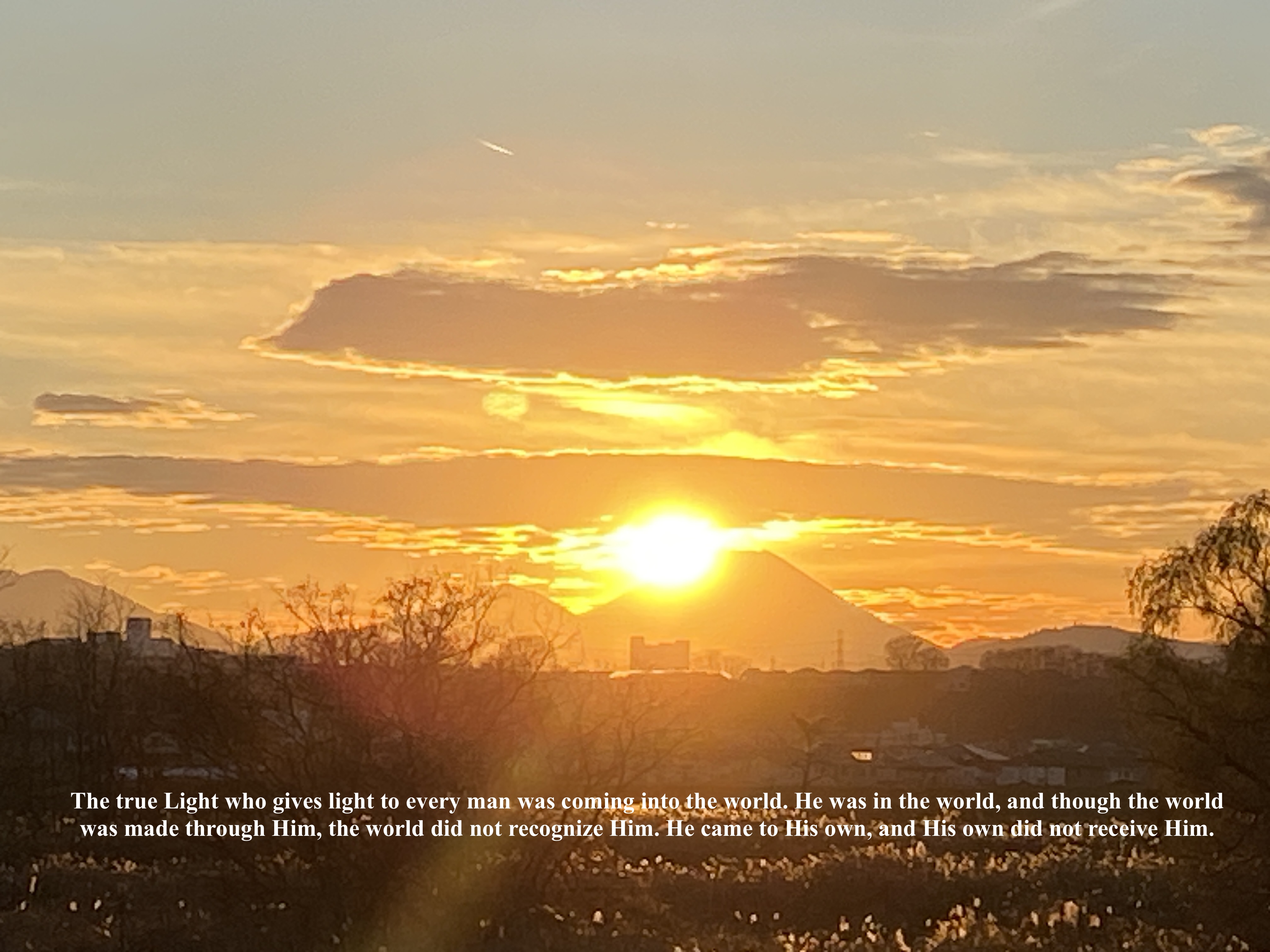
Mt. Fuji is one of the most awesome sights I know. I see it every day for most of the year and it still commands my attention every time.
At this time of year, if you catch it at just the right time and place, you can capture a diamond effect as the sun sets or rises behind it. For Tokyo, we can see this phenomenon at sunset in the 3rd week of December. One of the most popular spots for this is Mt. Takao.
I took these pictures on December 18, 19 and 20 last week from the Tama River in Tachikawa. I didn't really catch the diamond effect. I wasn't in the best place or even using a proper camera, but I still like the pictures and hope you do, too.
As it's Christmas Eve here, I am conscious of what a gift Mt. Fuji is. More than that, I'm thinking of what a truly awesome giver could have given us the gift of Mt. Fuji (and the gifts of the sun and the stars and hair and skin and opposable thumbs . . .)
And since Christmas Eve is the beginning in one way of the Christmas story, I thought it might be appropriate to reflect on the beginning.
And God said, “Let there be light,” and there was light. Genesis 1:3