

Home to Fuji and back in a day
Greetings cavedwellers,
Mrs. Caveman knows me better than I know myself. About a week ago she asked me, "Are you going to climb Mt. Fuji this year?" I thought that was a strange question. Another hike up there was the last thing on my mind. Well, here it is just a week later and I am blogging about another hike up Mt. Fuji.
Maybe she just wanted to get me out of the house for a day?
This time, I opted to go up from the south side. We live to the northeast of Fuji so I have always avoided that side because it seemed too inconvenient. The usual routes to get to that part of the mountain from here would entail long, expensive train rides. No thanks. The Caveman is a cheapskate. Well, on a few of my recent trips to mountains on Izu, I passed through Gotemba and realized I could take my scooter to the area around the Fujisan trailheads more cheaply than taking the trains.
I climbed the Fujinomiya Trail from the 5th Station.

Let me get the statistics and details out of the way.
Getting there:
The trailhead is on the Fuji Skyline (Route 152). This is closed to private traffic during the hiking season between July~September 10th and you must go to the trailhead by bus. There are buses from Mishima Station, Shin-Fuji Station or Fujinomiya Station if you are coming by train. If you are coming by car, you can get much closer to the trailhead than one of those stations. Fujikyu Bus Co. is the bus company that runs from the train stations. Even though I can speak and read Japanese, I find their bus schedules notoriously difficult to understand and even hard to find. Using googlemaps to check transportation routes doesn't give you their accurate schedules. Fujikyu's phone number for that area is 0545712495.
Since the Skyline is closed to private traffic, you still need to take a bus for that part of the trip. You can park at Mizugatsuka and catch a shuttle bus from there to the trailhead at the 5th Station's bus stop. (Fujinomiyaguchigogome 富士宮口5合目). That shuttle bus runs from 6 am til 5 pm on the hour. It's about a 30-minute ride. ¥2,000 roundtrip. Parking at the Mizugatsuka Parking Lot is ¥1,000.
This shuttle is run by a different outfit and was really hard to find on the web. If you can read Japanese, this page will help you: http://www.pref.shizuoka.jp/kensetsu/ke-210/fujisan/ Click on 2 よくある質問and a PDF with prices, schedules and departure points for shuttle buses to the traiheads of both the Fujinomiya and the Subashiri Trails will appear. I just checked this link (August, 2023) and it's dead. Rather than put up another specific link that is likely to go dead, I'll suggest you try this search yourself of the Shizuoka Prefecture's page Good luck.
The hard lesson I've learned about public transportation in the mountains is to check, check, check--and then check again. More than once I have had hikes "extended" by miles when I got out of the woods to a bus stop only to find out that the bus I'd planned on riding wasn't running that day. Bus schedules that change with the various natural and holiday seasons are very easy to mistake.
The hike:
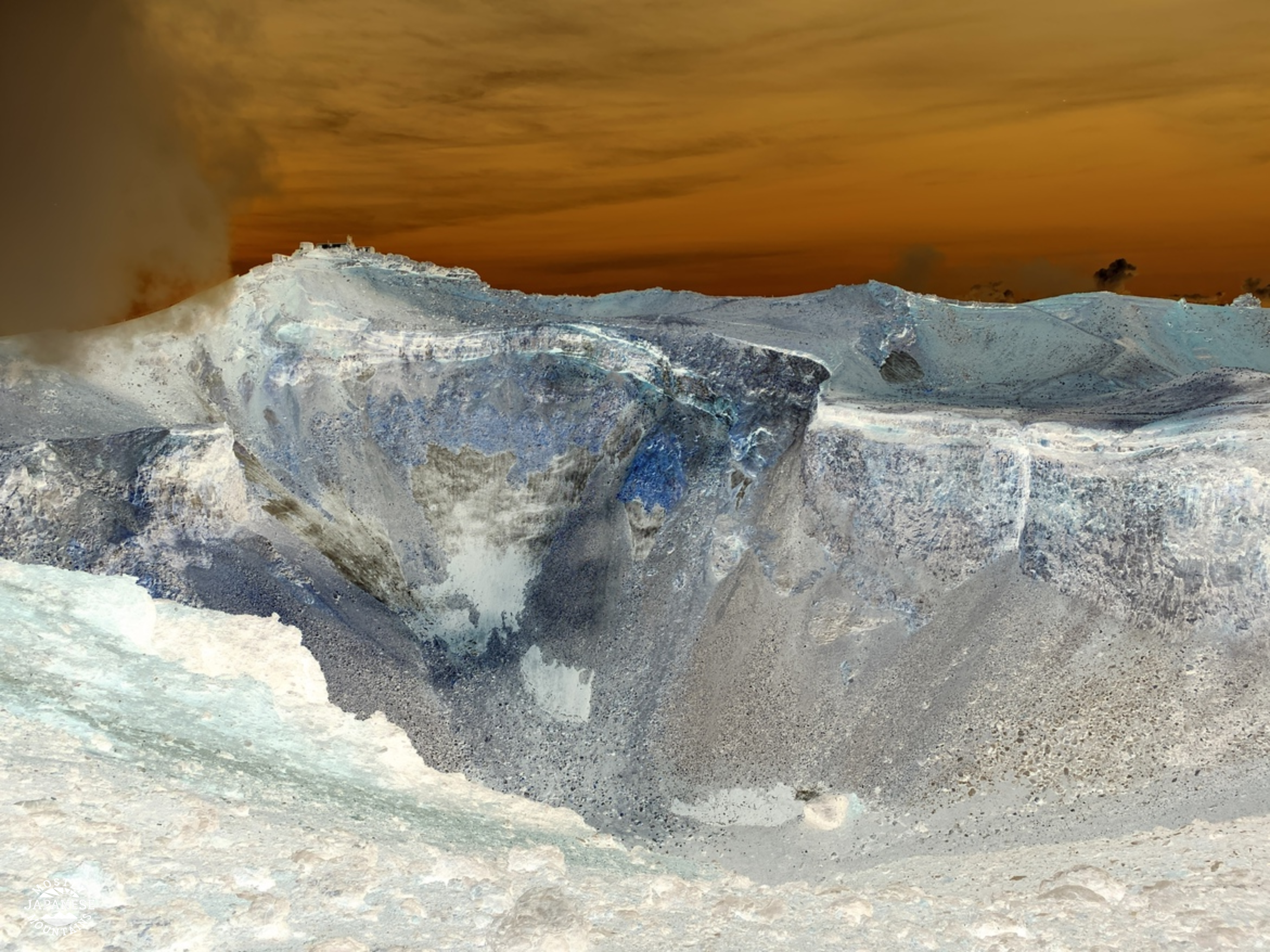
I got on the first bus at 6:00 so was on the trail at 6:30. I got to the Fujinomiya Shrine at the top around 9:30 and then walked all the way around the crater and just a little passed the Fujinomiya Shrine where I had lunch on a rock at the top of the Subashiri Trail around 11~11:30. From there, I headed down to Mt. Hoei before bouncing back to the Fujinomiya Trail to get to the bus stop. I was back at the bus stop about 1:45. It was 13.5km. The starting elevation was 2,400m and the top of Fuji is 3,776m. During the hike, I went up 1,652m and down 1,640m.
Weather:
Observations/Recommendations:
This was my first time to climb Fuji during the day successfully. Some friends and I were turned back by bad weather on a previous attempt a few years ago. The convenience of a daytrip was nice. Even though it meant leaving home at 3:00 am, it was nice to be home for dinner that night! That is a major pro of doing Fuji this way and from this route. Another pro for me of this plan was the different perspective. Since most of my life I have been looking at Fuji from the northern side, it was neat to look at it from the south. Mt. Hoei and its crater on the south side are cool. Cons of this type of schedule include the loss of the view as the morning progresses. Fuji typically gathers a lot of clouds by about 9 or 10 am at this time of year so the best views of it are while you're still on your way up. By climbing at night and catching the sunrise on top I was able to get long views before the clouds came. When I was on top yesterday, I couldn't see much of anything down below. Another con is the sun. I didn't feel that it was particularly sunny . . . but I got a sunburn. And that is despite wearing a hat and sunscreen.
Clothes. I spent most of the day in shorts and a t-shirt. I did have a fleece with me and a few other items but didn't need the fleece except when I sat down to eat. That is a pro of doing it during the day. At night, it's coooooold and I needed a wool hat and an actual jacket.
I did notice that the type of hikers I encountered on a daytrip tended to be different than on the overnight trips. There were quite a few families with kids and this was, in many cases, a bad idea. Many of the kids were fine. They are like monkeys. They aren't as heavy as adults and seem to be able to climb well. Some other kids, though, were over-tired and miserable. Please, know your own and your kids' abilities before you decide to bring them up there. I saw more than one father carrying two backpacks. I saw some kids just passed out on the trail and parents trying to coax them up to get moving. One mother was carrying a backpack and trying to piggy-back her (rather large) child.
There are lots of websites with information and tips on climbing Mt. Fuji. It's not my intention of being the definitive guide to Mt. Fuji with this post. I just like sharing my pictures and experiences! If you want to ask me any questions, feel free. You can even do that anonymously if you like. None of the comments I receive get published until I look at them so if you want to say something just between you and me, you can do that.
Let's look at some pictures.


Nice one! Knocking it off on a day hike is certainly a novel way and also beats the crowds that crawl up there at nightfall. I take it this time the young fella wasn't keen to follow dad up the south side?
ReplyDeleteHe probably would have come . . . but he wouldn’t fit on my 50cc scooter. :-) But, seriously, he's in high school. Even in August he's being kept busy. Stay cool!
DeleteOh, by the way, what about Motosuko? Did you like that area? Do you have any recommendations? It's not imminent, but I'm thinking that corner of the world needs exploring. See ya,
Motosuko is nice and nearby is Ryugadake. There are a couple of descent campgrounds too. I plan to return this autumn to climb Mt. Kenashi as an overnight loop hike.
DeleteI think you've given me an idea for tomorrow. If I go early enough, maybe I can knock those out in a day.
Delete