Mrs. Caveman combined a little leaf peeping with some lava leering yesterday. We dropped by the Onioshidashi Volcanic Park just below the volcano, Mt. Asama. It was even cooler than I imagined. If you can get there, go. Admission is 700 yen for adults.
A word about the name, Oni Oshi Dashi is a compound of the words for "demon/ogre" 👹, "push" and "out." The name probably is meant to evoke the thoughts of the locals watching eruptions back in the day. It certainly could cause one to think the earth was spewing something evil--kind of like Linda Blair's green vomit scene in the Exorcist.
My only regret is that it was a bit cloudy. It was still impressive but I couldn't help but thinking how amazing this would be on a super clear day.
I'm not going to comment much because I already have something else I'd like to blog about and the pictures say more than I could.
The Lennon family visited in 1977. John loved nearby Karuizawa.
That's Mount Asama
They also call this one Godzilla. I still see King Kong.
Does that mean I fail the Rorrock test?
Can you spot the Karuizawa Toy Kingdom in this picture?
Phosphorescent moss
This one is a dog. I can see that.
Can you spot the face in the next rock?
It made me nostalgic for New Hamphire's Old Man of the Mountain.
These last few are not from the Onioshidashi Park. We dropped by the Asama Otaki (Asama Big Falls) before going home. They are about a 15 minute drive from the volcanic park.
Greetings cave kids and critters. It's one in the afternoon and my eyes are drooping as if it were one in the morning. I forewent some sleep last night in order to get up and go to see the diamond effect of the sun rising behind our local volcano, Mt. Asama.
As is often the case, before embarking on one of these adventures, I was wondering if it was a good idea. The weather forecast wasn't perfect. It was super hot last night and I couldn't sleep.
As is also often the case after one of these adventures, I AM SO GLAD I DID IT! The weather was perfect! We caught the diamond effect really nicely. We had great views of Mt. Fuji, Yatsugatake, the Northern Alps, Mt. Azuma, etc. The temperature was comfortable. What a great morning hike this turned out to be.
Let me give you the stats and then show you some pictures.
Free parking behind the visitor's center. There is a JR bus to the Takamine Hotel bus stop in front of the trailhead. It's 45 minutes to there from Komoro Station or 55 minutes from Sakudaira.
Lowest: 1,970 m Highest: 2,404 m Total Ascent: 768 m Total Descent: 768 m
Technical considerations/difficulty:
A bit steep at times but there are no chains or ladders, just a few ropes for guidance. The ridgeline from Yarisaya and Nokogiri is not a place I would want to fall.
Facilities:
The visitor's center is well-appointed. The Takamine Hotel has a commanding view of the plains below. There is an emergency hut near Mt. Kurumazaka in case the volcano erupts.
Thoughts/observations/recommendations:
What a great area this is. My recommendation? Go and hike there!
I found out about the diamond effect on Mt. Asama by coming across a flyer for a tour a few months ago. Armed with the date, time and location for viewing this sunrise, I took my friend Michael to see it on our own. In order to not get mixed in with the crowd, we started hiking earlier than the tour group. We got to the viewing point much earlier than they did. It was worth the wait, though. It was a great hike!
We got to the viewing spot at about 4. Sunrise was 5:12.
Mt. Azumaya, one of the 100 Famous Mountains. I got rained on a lot there earlier this month.
Near here, it started to smell like sulfur. We encountered a sign warning that we were about 2 km from the volcano and that we shouldn't stick around long.
That's not toxic waste. That is what a river near a volcano looks like.
Hello Cavedwellers. It's been a while since I've hiked anywhere blogworthy. How are you doin'? I'm grateful to be alive, as always.
We had a window of nice weather yesterday. That's so nice. Some years the rainy season never allows for a sunny weekend day. This year it is working in reverse and it's been raining on weekdays. Hooray!
I went to a peak just to the south of Mt. Asama. It was great. (Any mountain is great, providing you get home alive.)
Getting there/getting around: I drove and parked on a dirt road. No bus stops in evidence. You could just walk from Shinano Oiwake Station. It would be about an extra hour or two.
Map: Yama to Kogen Chizu 19浅間山軽井沢・長野原の山々ASAMA-YAMA KARUIZAWA-NAGANOHARA-MOUNTAINS
Elevation:Lowest: 1,051m Highest: 1,677m Total Ascent: 761m Total Descent: 761m
Technical considerations/difficulty:
A GPS device is a good idea here. Most of the way is very easy to discern, but at one or two points, you could get twisted around.
Most of this was just a very pleasant walk in the woods. As I was driving to the trailhead, I entered a long stretch of un-paved rugged road and decided to start walking ahead of time in order to save my car the wear and tear. Since I did not start at a regular trailhead I did need to do some bushwhacking to get to the trail, but with my smartphone in hand, it wasn't too hard to find. I did cut across some private property on the way but nobody caught me so no harm, no foul. (This reminds me...If a B and E is done in the woods, has a felony been committed?)
From the trail entrance for most of the way, it was just a nice path through the woods.
There was only one place I encountered any ropes. If you notice from my track, there is a bit of a detour before going to the peak. That trail leads to a cave (evidently for zazen meditation). Getting up to the cave, there is one steep part with a rope. It's not challenging or dangerous, though.
This hike is on the side of the volcano and there are safety considerations. Below are the notes I included for my hike on the mountains to the west of Mt. Asama in May:
First and foremost, it's important to remember that this is an active volcano and there are usually restrictions on where you can go. Depending on the air quality, you may not even be able to climb it at all. The authorities have 5 levels of caution. 1=no restriction, 2=the fewest restrictions, 3=climbing nearby allowed with more restrictions, 4=local residences are in danger and should prepare for evacuation, 5, Run you fools!
You can check the current levels on this page from Komoro City's web page. It's in Japanese but you can figure out the level by finding something that looks like this near the top of the page:
火口周辺警報(レベル2:火口周辺規制)(令和5年3月23日)
火口周辺警報=caldera area warning
(レベル2:火口周辺規制)=Level 2: restrictions around the caldera
(令和5年3月23日)=Reiwa Year 5, May 23
Here are some pictures for your perusal:
Where I parked. Next to where I parked, there was a sign noting the time and date of a bear sighting just 2 weeks before. (Let's not divulge that factoid to Mrs. Caveman.)
The Nigori River. (濁川) Nigori means something like pollution or clouded. I don't think the water is dirty, however.
I am curious about whether it is potable or not, though. I wouldn't hesitate to drink out of most mountain streams around here. This, however . . . I wonder if this water needs purification to be drinkable or if it's beyond hope. Does anyone have any input on this?
The Chinotaki ("Blood" "Falls")
Around here is the only place I smelled sulfur on this hike. On the other side of Asama, the sulfur smell was quite strong.
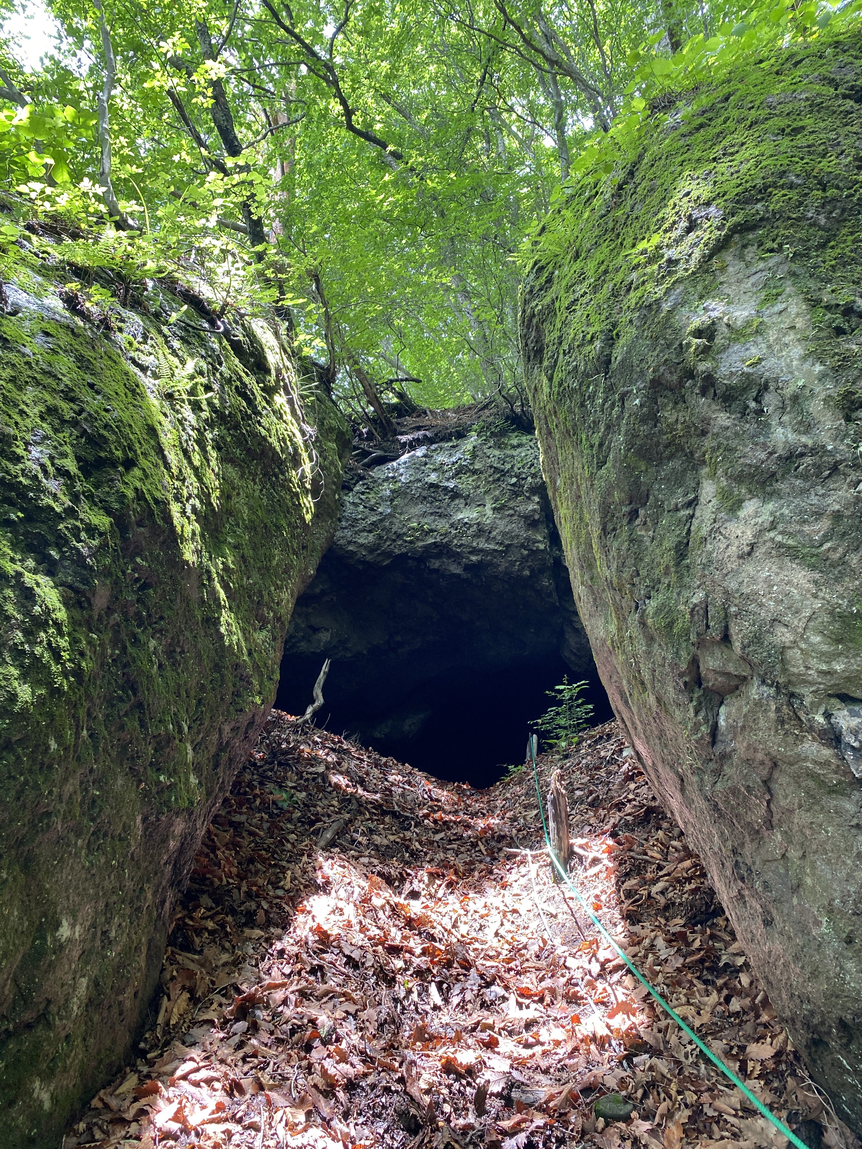
On the way to the cave . . .
Inside the cave, there are human and animal footprints. I wonder what goes on in there at night.
After dropping by the cave, I headed toward the peak and got my first views of the day.
Kengamine on the left, Mt. Asama on the right.
That post marks the top of Mt. Sekison.
Looking east toward Gunma and beyond. Mt. Myogi is in the picture. So it Ryokami and Toridani.
Facilities: Nothing
Thoughts/observations/recommendations: One thing I liked about this hike was that it was pretty secluded. Karuizawa is a happening place but I only bumped into two groups of people on my hike. I had the peak to myself.
Bring bug spray. I had planned to pick some up at 7-11 but they didn't have any. There weren't mosquitoes but there were giant bugs with swept-back wings. I am pretty sure they were horseflies. If you stand still they'll land on you and give you a painful bite.
I had the pleasure of Mrs. Caveman's company for (some of) this trip. While I was hiking, she was sketching at the Wild Bird Preserve. Check out her blog here: Put Out Into The Deep
On the way home, we dropped by the Shiraito ("White" "Thread") Falls and the Ryugaeshi ("Dragon" "turn back") Falls.
Shiraito Falls
Ryugaeshi Falls
That's all for today. Stay safe. Subscribe, blah blah blah. Or not. That's OK, too.
Do check out Mrs. Caveman's blog. It's worth reading.