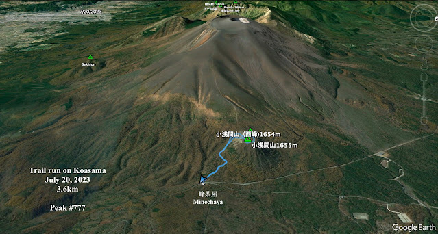
Location: Mt. Koasama, Karuizawa
Starting and stopping point: Toge Teahouse 峰の茶屋
Peaks bagged: Koasama west peak ~~ Koasama
Getting there/getting around: I drove
Map: Yama to Kogen Chizu 19 浅間山軽井沢・長野原の山々ASAMA-YAMA KARUIZAWA-NAGANOHARA-MOUNTAINS
Weather Information: Asama Weather
Total Time: :40 Break time: 0 Distance: 3.6 km
Elevation: Lowest: 1,404m Highest: 1,655m Total Ascent: 258 Total Descent: 258
Technical considerations/difficulty: Loose gravel/sand. Nothing steep. Very runnable.
Facilities: Public restroom across the street from the trailhead. Emergency shelter (in case of eruption) at the trailhead.
Thoughts/observations/recommendations: Today I bagged my 777th peak on a quick run after school. Mt. Koasama ("Little Asama") is a bump on the eastern side of Mt. Asama--the volcano. It's about 800 meters lower than Asama. I do wish there were fewer clouds. The view of the top must be cool.
Today's listening: Just my own huffing and puffing
S'up, cavedwellers? I'm not going to write much. There is no reason to spend more time blogging than I did running!
Hope you're all having a great summer!
This is at the trailhead. The building is Tokyo University's volcano monitoring station.
This is a campground in Tsumagoi.
The west peak
Explanations of the restrictions and the danger. Level 1 means un-restricted access to Mt. Asama. Now it is Level 2. You can't go closer than a few km from the crater.
The box to the left of the sign is to deposit hiking plans. (I do mine online. Ask me if you want to know how. I never go into the woods without telling someone my plans.)
That's all. See ya!


