Greetings, ladies and gentlemen, boys and girls, spelunkers and cave enthusiasts of all ages. Welcome back to my mancave. I'm glad you could drop by. Pull up a rock and let me tell you a tale of a fateful trip. It started from a tropic port aboard a tiny ship.
Oops. Wrong tale. This one is about Golden Week, 2022.
I was in a quandary as to what to do for a Golden Week trek. There were a lot of options to sift through. I finally decided to head to a particularly hard-to-get area to try and complete some trails that I haven't been able to yet.
I love maps and have a few walls covered with them. Maybe I am O.C. or maybe it's just because I'm a guy. (I think it is the latter.) But, for whatever reason, any mountain trail I see on those maps must be hiked. It's not enough for me to climb every mountain a la Maria von Trapp, I have to trod every trail.
This section of map below shows an area between Chichibu City in Saitama to the north and Okutama, Tokyo to the south. The dark blue line represents a stretch of trail between Mt. Imokinodakke and Mt. Tenmoku that I have wanted to complete for a while. It's been frustrating because this area is kind of remote and it's not really possible to do in a day. Even cutting it up into sections has proven impossible. The light blue lines on the map represent plans I have made that were thwarted on the ground. Twice I had to turn back because I encountered impassible spots on the trail.

So . . . I decided to make an overnighter and knock out as much of this as I could.
Here's what the map looks like after my latest trek. There is only a mile or two stretch left but even just that will take another whole day.

Let me get the transportation and stats out of the way and then I'll show a Google Earth view of the hike.
Getting there: train to Seibu Chichibu Station--the end of that line. Then a bus to Mitsumine Jinja (Shrine)--the end of that line. This brings you to Mitsumine Shrine/the Mitsumine Visitor's Center at about 10:30 am. I would have preferred to get there earlier but that's basically the earliest I could get there from where I live. If you were coming from Tachikawa, you would have to get on a train before 7 to make it.
Coming back: bus from Higashi Nippara Bus stop to Okutama Station (27 minutes). Then the Okutama Train Line back to civilization.
Staying: The Toridani Refuge Hut. I stayed inside the refuge hut for the first time in a while since COVID started. People have discouraged their use except in emergencies since COVID started but people seem to have lightened up recently. You can pitch a tent outside here, if you like. There is water and a rustic toilet. (Be prepared to bring your used toilet paper home with you. Ewww.)
Route and Stats:
The first day I headed south toward Mt. Kumotori for something like 7 or 8km and then turned left (east) onto the Nagasawa Hairyo Ridge. I followed that for another 10km or so to Mt. Toridani and then descended just below the summit to spend the night in the Toridani Evacuation Hut. I had planned on going from the Toridani Hut directly down to a bus stop in Nippara the next morning but that trail was closed so I decided to retrace some of my steps so as to descend via Mt. Tenso.
I have had three or four smartphone apps and computer programs analyze the GPS data. Depending on which one you believe, I hiked somewhere between 30 and 45(!) kilometers. The consensus among the digital entities seems to be about 35 kilometers. That's about what my body feels like, too, so I'll believe that. Day 1 was 19km and day 2 was 16km.
One app reports that I burned 7,288 calories. I believe it. I came home more than 1kg lighter than when I left. (It'll probably be back by tomorrow.)
One app reports that I went up ☝3,648m and down 👇4,076m. According to that app, apparently, I crossed a milestone of sorts with this trip. Cumulatively, I've now climbed over 300,000 meters in elevation.
I'm American. As soon as I find out what that means in feet or miles, I will probably be impressed.
I may not be much, but I'm all I think about. 😉😉😉
This trip had me summiting 11 mountains, and 3 or 4 of them twice!

This is the Seibu Chichibu Station. I was surprised at how many people were lined outside for my bus. They had to order a second bus to accommodate us all. I have mixed feelings about the number of people. I go to the mountains because I like to get away from people. On the other hand, I'm happy to see Japanese people back to recreating and I'm happy to think that maybe the tourist industry is doing better.

After an hour or so on the bus. This is the sign that greets you at the terminal. The shrine and the visitor's center here are worth seeing. I skipped them this time because I've been there before but I'll put up some pictures I took on past trips.

The Mitsumine Shrine (2019? 2020?)


The visitor's center had much cooler displays than I expected. Definitely worth dropping in if you go by it.


I took this picture when I was headed toward Mt. Kumotori a few years ago. That was a great trip. I wish that I had started blogging before I climbed Kumotori. There are actually many worthy mountains that I hiked before the blog.😢

Mt. Kumotori a few years ago. I love that mountain. I've climbed it 6 times.
Kumotori means something like "cloud" "gather". Being the highest point around, it does gather clouds around it often.

The refuge hut on top of Kumotori. It has breathtaking views and deer all around.

From Kumotori


OK.....back to this week.
I mentioned there were a lot of people on the bus. There were also a lot of people on the trail. There is a mountain lodge on Mt. Kumotori and it was booked solid all week. I don't think it gets that much business in most regular years because Kumotori is a challenge.
Happily, the crowd thinned out when I turned off onto the Nagasawa Hairyo Ridge. I didn't see anyone else all day.
This is near the beginning of the trail.

This is near the top of the first mountain, Myohogatake.


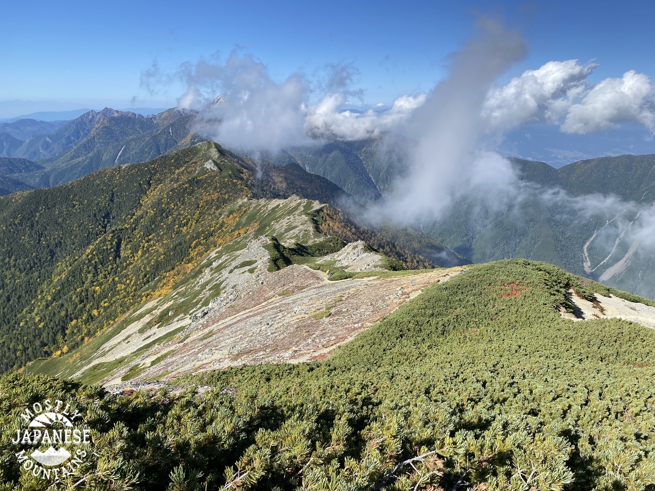
Looking toward the Nagasawa Hairyo Ridge, where I was heading.

One thing I noticed about the first several miles of this trip. There are a lot of sturdy, well-maintained break areas on the way.

I couldn't make out all that is written on the plaque, but this is a memorial for the shrine.


I was not making the time I'd hoped to. It was a slow slog much of the day and I was running to beat the sunset. These next few pictures were near the top of Toridani, my last mountain of the day. I was really tempted to stay on top for the sunset but decided against it.


I made it down to the refuge hut before sunset. Yay. There was one guy, (middle-aged Japanese man) there already. He had slept on Kumotori the night before.
It's a nice hut. I hear there is room for 7. It would be a tight fit.

This is looking toward downtown Tokyo. Can you pick out Otake?
After waking up at 4:10 am, I set off at about 5:30. It was a little clearer on day 2. Unfortunately, day 1 was pretty hazy and I didn't get many long views.
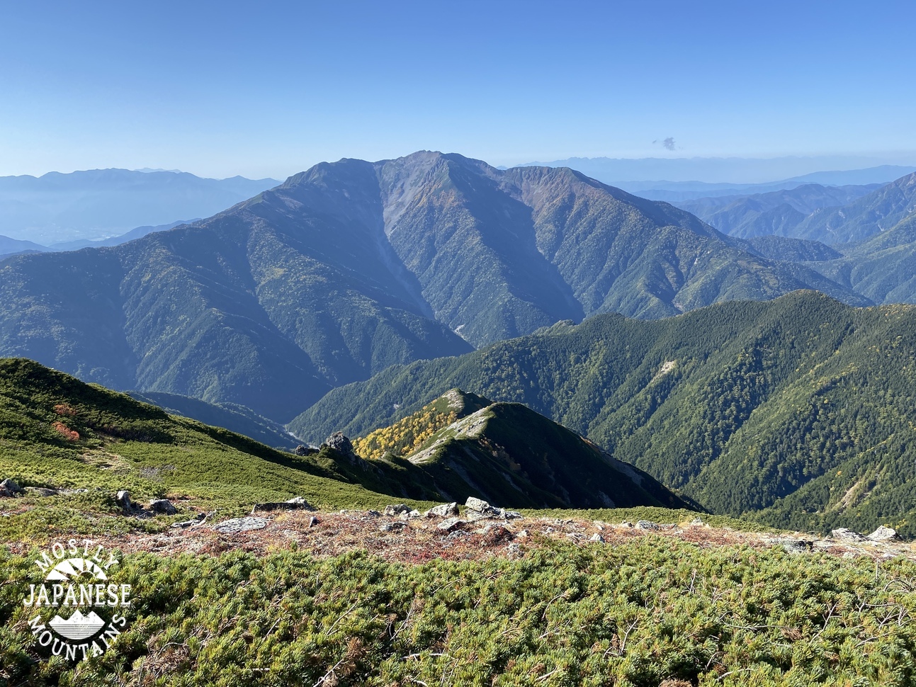
The mountain above my logo in the picture below is Mt. Ryokami, one of the Famous 100 Mountains according to Kyuya Fukada's book.

Mt. Ryokami, like many mountains in Saitama, is not very high but can be challenging. I would even say dangerous.
A hint of a rainbow!🌈


The shrine on Mt. Tenso.
It got really steep from here on down. I was so glad I was going down this route and not up it!

The trail lets out onto the street near the Hatcho Bridge over the Nippara River. It was a pleasant walk along the river for the last few kilometers to the bus stop at Higashi Nippara.
There is trout fishing in this river and there are limestone caves you can visit, too.

This is the Inamuraiwa ("rice plant" "village" "boulder"). It's a great landmark. There is a trail to the top of it and I've been dying to get up there for a few years. There was a big typhoon at the end of 2019 which devastated a lot of trails. Then COVID came right after that and much of the repair work still hasn't been done.

This is just someone's house in Inamura. What a beautiful garden.

My dogs were barking!
I had planned on putting more of my body into the water but it was so cold I thought my heart my stop.

That's all for now. Drop by the cave anytime.
Don't forget to subscribe. If you feel like helping out a mooching mountain man, I'd love it if you dropped something in the tip cup to support this site. I'd be grateful for the help with train fare or gas money to keep these reports coming.