Technical considerations/difficulty: This portion of the trail is very suited to trail running. No ropes, chains or ladders. Your grandmother could do it.
Facilities: Lots of viewpoints. One public toilet on the way.
Thoughts/observations/recommendations: I'm sure there are nice views to be had on a clear day. If you hike in Tokyo, you've surely passed through Ome Station. If you've never exited the station, you should. It's a nice area to walk around. It's famous for having old movie posters around. And for cats. There is cat-themed artwork all over the place. Hence, it's the purrfect place to visit.
I was happy that the cave boy (my son) was available to come to the mountains today. Being a Japanese high school kid, his time is at a premium. We were able to squeeze a few hours out of his studies for a walk on the trail from Ome Station to Futamatao Station. It wasn't very clear so it was not the best day for pictures of the mountains. The best pictures of the day were of the cave boy.
I estimated I would end today with my 699th peak under my belt and was thinking of going somewhere noteworthy for number 700. I guess I don't count too well because my climbing app informed me that I had in fact just reached my 700th mountain on this hike of fairly forgettable hills.
Getting there/getting around: There are buses bound for Jinba Kogen departing Takao and Hachioji Stations that stop at the trailhead. I parked my scooter at the temple next to the bus stop where the trail starts.
Map: This trail is visible on YAMAP. It doesn't appear on the Compass application or on the Yama to Kogen maps.
Elevation: Lowest: 201m Highest: 597m Total Ascent: 973m Total Descent: 975m
Technical considerations/difficulty: This trail isn't really too difficult to follow, but there are very few markers and it isn't maintained. There are several steep spots without any stairs or chains. It would be possible to get lost and find yourself in a pickle if you don't have a nose for finding the trail. This trail reminds me of the adage here not to go down if you're lost. It's easy to go down into some place that you can't climb back up out of. These hills are not very high but the trail goes up and down quite a bit so it is slow-going.
Facilities: Nothing
Thoughts/observations/recommendations: There is a reason this trail doesn't show up on most maps. It's not got the most breathtaking views or much else to recommend it other than being a walk in the woods. It was a good workout and this trail gets points for the solitude factor. I only saw two other hikers. The only reason I did it was to tie up some loose ends with the other trails I've hiked in the area.
Not much to say, so I won't say anything else. Have a great day!
Mt. Jinba is the mountain about 3/4s of the way to the right side of this picture.
Ongata Junior High School is below in the foreground.
I have gone by this place once or twice. It looks intriguing.
A little research reveals that it is worthy of more research! This place is the Daigo Ecology Village referred to in this article. DAIGO
Yesterday was my last hurrah for the winter break. I opted for an oldy but a goody, Mt. Otake* in western Tokyo.
*Otake="Big Peak". There are approximately 5 billion mountains with this name in Japan. It's confusing.
Mt. Otake is one of the mountains that got me hooked on mountains. It is quite prominent and is visible from my home--and from a million other places.
It's become a meaningful place for me--if a little bit boring now because I've been up and down it from every possible way. I've climbed it with my son, a nephew, the friend who was my best man, and with other friends as well as alone. Yesterday was my 8th time.
Otake, sticking up the way it does first enticed me to climb it several years ago. I think my first time up it was a challenge. I was a chain-smoker and lived a very sedentary life. I was also on a steady diet of McDonald's. The first few times up, I took the shortest, easiest routes.
In time, the mountains around it also gained my attention. In particular, there are two little bumps that look a bit like camel's humps to the south (left). The first time they really spurred my attention was when I saw the sun set between them from Akigawa Station one night. That was just serendipity that I caught that sight. That made me wonder what they are called. (Mazukari/"Horse Head Hunt" and Tsurashi/"Crane Leg").
Eventually, I got the idea to walk all along the profile of the mountains I
was seeing as I looked west. It seemed like a gargantuan undertaking when I first conceived it. Since then, I've done it several times. Yesterday was the most complete trek though. I went from Musashi Itsukaichi Station in the southeast to Okutama Station in the northwest.
Getting there/getting around: For this hike, I just used trains. I went from the terminal of one line, Musashi Itsukaichi Station, to the terminal of another line, Okutama Station. Most people who hike Mt. Otake from Musashi Itsukaichi Station take a bus from the station to one of several trailheads before starting. My route meant that I was walking on pavement for the first 5 kilometers or so.
Elevation: Lowest: 178m Highest: 1,266m Total Ascent: 1,816m Total Descent: 1,662m
Technical considerations/difficulty: Although these are not very high mountains, they do offer a challenge to people who have come for a one-off day in the mountains. I did notice quite a few more hikers huffing and puffing on the trail yesterday than I do most days on other mountains--even really challenging ones. I think it's probably because Otake is close enough to downtown to attract daytrippers that don't spend any time to speak of on the trails to come for the odd hike. For a reference point that many will understand, the ascent to Otake is more than twice that up Takao from the bottom, ie, not taking the cable car.
This area is all well under the tree line and not very exposed. There are very few chains or ladders except on the last portion. From Nokogiri to Okutama Station, the are some steep spots with lots of chains.
Facilities: No public restrooms, waterholes or commercial enterprises.
Thoughts/observations/recommendations: Otake is a great place to make a memory. Since it is so prominent, it is visible from just about anywhere--including downtown Tokyo. If you would like to climb it, but don't want to go on a death march, try going up from Mitake. Below the Mitake Shrine, there is a cable car accessible by bus from Mitake Station on the Okutama Line. From that cable car station to the top of Otake would be just a few hours roundtrip. While you're in the area, you can drop by the very popular and picturesque Mitake Shrine and walk by the Rock Garden and see a few really nice falls. Around the cable car and near the shrine there are plenty of opportunities to buy souvenirs or grab a meal in a restaurant. I taught in Akiruno for many years and one of my former students lives in that neighborhood by the shrine. They run an inn. I always got a kick out of the fact that his commute to school began with a cable car. Sometimes he would miss school because of snow around Mitake even though it was clear down below.
Here's what the map looked like:
This is where I started, Musashi Itsukaichi Station.
Incidentally, there are bicycles for rent across the street at 東京裏山ベース. I've never been in that place, but have bicycled a lot in the area and recommend it highly.
Took this from a bridge while still walking on the street . . .
From the station, I walked along the Route 33 as far as the Jurigi intersection and turned right. This guy is standing guard of 十里木ランド (Jurigi Land)--a BBQ/fishing spot on the river. (Never been there either.) Jurigi Land
This is where I started to get closer to the trail. This is the Komiya Education Center (小宮ふさと自然体験学校). It's a former elementary school.
After a bit more on the pavement . . . I finally turned in to the woods at this temple. 明光院
It was a gorgeous day.
I chuckled to see Oyama remembering I've already been up it 3 times this month.
There are some great rocks along the way. One is called Tsuzuru Iwa (Tsuzuru Boulder) and attracts many climbers. I'd like to climb it someday but don't have any ropes. Anyone out there have equipment want to take me?
This spot is called Fujimidai, "富士見台." Fuji+view+pedestal. Just about every town within 100 miles of Mt. Fuji has a section called "Fujimi."
That is Mt. Gozen. It's actually higher than Otake so I don't know why it looks lower.
Two years ago tonight I spent a very cold snowy night on top of Gozen.
On the last leg of the trek, just before Mt. Atago, I detoured onto the 登計トレール-- Toke Trail where it intersected my trail. I was happy to try this route. I remember Mt. Atago from past excursions. It ends the hike with a long, steep stone stairway that gives me vertigo. :-) Also, after being in this area so many times, I was happy to tread on a road I've never trod.
The Toke Trail morphed into the 奥多摩森林セラペーロード , (Okutama Forest Therapy Road). That is a project of a foundation in Okutama town for the promotion of health and well-being. There's information here in Japanese if you're interested. Feel free to puzzle through it with google translate if you like. It looks like they have some kind of guided tours for weary Tokyoites from downtown. Okutama Therapy Tours
The Forest Therapy Road has many unusual resting spots and even a few stylish buildings (locked that day) with fire places.
The parking lot of the Forest Therapy Road had all this swag in a chokubai (direct-selling) stand. They are very trusting. That's a lot of merchandise! It was good stuff, too. And cheap.
The destination. Okutama Station.
That's all for today. There will be a quiz later. I hope you paid attention.
Thanks for dropping by the cave. I'll be back in a few weeks. Stay warm.
I shouldn't be making this post. I should be in the mountains now. I've caught the Wuflu and have to stay in for a week or so. (I'm really not feeling that ill and am getting better quite rapidly. Don't worry about me.)
Since I can't be there in person, I've decided to go there virtually and blog about a few trips I made before starting this blog. This first one is of one particular bike trip I made out to Okutama and back.
Elevation: Lowest: 106m Highest: 1,161m Total Ascent: 4,120 m Total Descent: 4,120m
Thoughts/observations/recommendations: This was a very cool ride. The Shuyudo winds up and between Mts Mito and Tsukiyomi from Lake Okutama on the north to Hinohara Village on the south. It's a popular road with bicyclists, motorcyclists and sports car drivers. It gives breathtaking views of the lake below and there are a few parking lots with great lookout points to take in the sights. You can get a great view of the profile of the mountains along the Ishione (Rock Ridge) across the lake. The weather didn't cooperate very well for visibility on this day, unfortunately.
You do need to keep your wits about you. I have come upon more than one accident on that road.
This closeup is focused on the Shuyudo area.
One thing I like about these animations is that they are always 30 seconds long. If it is a short hike, the little guy just crawls along. On something long like this, he runs faster than Charlie Sheen on Bolivian marching powder.
This particular bike ride is one I've done a few times. It takes me a couple of hours to get to Lake Okutama. Then, I ride along the north side of the lake for a few more miles . . .
. . . before crossing over to the south side and entering the Shuyudo around the base of Mt. Mito.
Shuyudo translates to something like excursion/circular/fun road. It's gated and locked at night. The opening hours are 8 to 7 from April through the end of September. The rest of the year it's open from 9 to 6.
On this particular trip, I encountered lots of monkeys.
And, of course, I encountered the monkey remains you saw in the first picture.
I still kick myself for not bringing that skull home. It was so cool.
If I recall, I actually saw that skull 3 times in 3 weeks. Once was on this trip. Then, I passed by the dead monkey a week later when hiking to Mt. Mito with my son. I managed to lose my wallet on that trip and returned the next week to retrace my steps. I didn't find my wallet on that trip but eventually, JR (Japan Railways) contacted me. They found my wallet near one of their ticket machines. I got it back in completely intact weeks after dropping it. I love Japan.
The Shuyudo is fairly steep and winding. It's a lot of work to go up it, but the views make it worthwhile. And going down is just too cool for school.
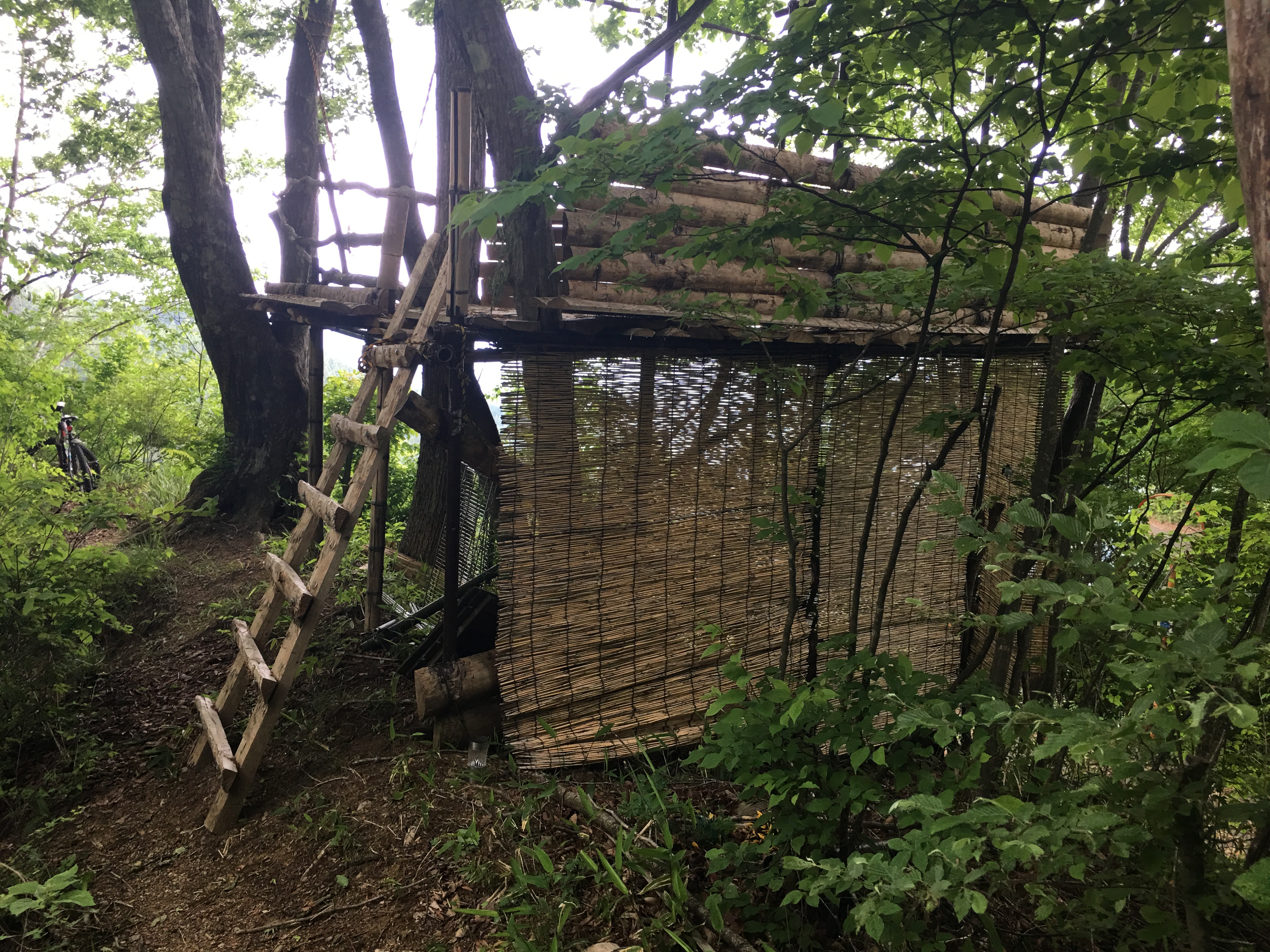
This is where I left the Shuyudo. Were I to continue on it, I would have soon passed the Tomin no Mori and then on into Hinohara Village from there. Instead, I did a little B and E to get through this gate into what I came to think of as Deliverance country. Seriously, you could almost hear Dueling Banjoes in the distance.
There were a few structures like this in that area. Is it a hunter's hide?
I got off the bike for just a short time to walk up to the top of Mt. Kurakake. It wasn't the safest place to be.
And that's all I'm going to say about that.
I'm stuck at home for another 3 or 4 (5?) days so I'm sure I'll be blogging more later. Take care and be sure to subscribe. If you don't, a pit viper might come and bite you.