Elevation:Lowest: 1,601 Highest: 1,931m Total Ascent: 476m Total Descent: 476m
Technical considerations/difficulty: A little steep in places, but mostly runnable.
Facilities: Nothing
Thoughts/observations/recommendations:
Very excited about the opportunities for hiking with the long summer days. I can escape work with enough sunlight to get in a nice, short hike before the sun goes down.
Peaks bagged: Kurumazaka Yarigasaya Tominokashira Kurofu
Getting there/getting around: There is a large parking lot behind the visitor's center. There is also bus service to Komoro, Sakudaira, and even Shinjuku. JRBusKanto runs a bus from the Shinjuku Bus Terminal. It takes 4 hours and costs ¥3,400. I think there is one departing Shinjuku around 10:30 and a return bus at 16:20.
Map: Yama to Kogen Chizu 19浅間山軽井沢・長野原の山々ASAMA-YAMA KARUIZAWA-NAGANOHARA-MOUNTAINS
Elevation:Lowest: 1,966m Highest: 2,404m Total Ascent: 493 Total Descent: 493
Technical considerations/difficulty: This is a fairly straightforward hike. It's not very long. The trailhead is at a mountain pass so you're already as high up as a car can take you. Most of the hike is below the treeline but when you pop out onto the peaks on the edge of the valley facing Mt. Asama it is a bit dizzying. There are no chains or ladders, but you do need to scramble over some boulders. I really wouldn't want to slip off of one of those rocks. Alltrails calls this hike "hard". YAMAP gives it 3 out of 5 for "strength". I don't know if I'd call it hard...Perhaps if you only put on your hiking boots once in a while.
At the visitor's center, there are the ubiquitous warnings about bears. I'm starting to pay a little more attention to them because there do seem to be more bear encounters in this corner or Nagano and Gunma than I'm accustomed to in other areas. That said, I am still not getting a bear bell. Wow, I find them obnoxious.
Facilities: The visitor's center is remarkably clean and large. There's a snack bar, rental helmets, poles, gaiters, brochures, some items of clothing for sale, vending machines, and restrooms. It's a happening place. Next to that is the Takamine Kogen Hotel which has a commanding view of the valley below and Yatsugatake beyond. Behind the hotel, there are more restrooms open 24 hours a day. There is no water on the trail. There is a very rudimentary emergency shelter on the trail. It's basically just a big tube open on both ends. I assume this is purposed more for protection from eruption than for anything else.
Thoughts/observations/recommendations: This hike was a bit of daytime reconnaissance for doing the same trail in the dark later this summer. When I was doing some trail research the other day, I came across an ad for a tour to see "Diamond Asama" at sunrise: Diamond Asama tour . That sounds like fun! I learned about the diamond effect from Mt. Fuji. As the sun sets or rises directly behind the mountain, rays of light get super bright. Now, I think it's nice that these people are giving a tour to see the effect--but they are charging money. One of the things the caveman dislikes--almost as much as he dislikes pretentious jerks who refer to themselves in the third person--is spending money. Armed with the date and place when the diamond effect is likely to occur, I decided to check out the trail in daylight ahead of time. It was a great excuse to go for a short hike after work on a Thursday afternoon!
Thankfully, there was another brief window of nice weather in this rainy season so that I could do it! We have had a few days of real torrential downpours recently so yesterday's clear weather was just the bees knees. It was almost as good as sliced bread.
And, hiking at that time of day, on a weekday no less, meant that I had the trail and peaks all to myself.
I saw this guy on my way up the road to the trailhead. I call him Fred. Fred the animal.
Inside the visitor's center
Looking down toward Komoro and Saku cities.
Much of the trail is like this. At spots, there are rhododendrons, too.
The Shelter. This is not your usual mountain shelter. I assume it's to shelter during an eruption. I've seen similar ones on the other side of Mt. Asama, too.
That is Mt. Asama. The air quality level is still such that we can't go near the crater. I can't wait until we can.
I live down there. Can't you see my house?
Heading back down
The hotel is on the left side.
The Bus Stop
Looking west
That's all for today. Thanks for dropping by my cave. Come back again. Subscribe if you feel like it. Leave a comment if you are of a mind to.
That's not toxic waste. That is what a river near a volcano looks like.
Hello Cavedwellers. It's been a while since I've hiked anywhere blogworthy. How are you doin'? I'm grateful to be alive, as always.
We had a window of nice weather yesterday. That's so nice. Some years the rainy season never allows for a sunny weekend day. This year it is working in reverse and it's been raining on weekdays. Hooray!
I went to a peak just to the south of Mt. Asama. It was great. (Any mountain is great, providing you get home alive.)
Getting there/getting around: I drove and parked on a dirt road. No bus stops in evidence. You could just walk from Shinano Oiwake Station. It would be about an extra hour or two.
Map: Yama to Kogen Chizu 19浅間山軽井沢・長野原の山々ASAMA-YAMA KARUIZAWA-NAGANOHARA-MOUNTAINS
Elevation:Lowest: 1,051m Highest: 1,677m Total Ascent: 761m Total Descent: 761m
Technical considerations/difficulty:
A GPS device is a good idea here. Most of the way is very easy to discern, but at one or two points, you could get twisted around.
Most of this was just a very pleasant walk in the woods. As I was driving to the trailhead, I entered a long stretch of un-paved rugged road and decided to start walking ahead of time in order to save my car the wear and tear. Since I did not start at a regular trailhead I did need to do some bushwhacking to get to the trail, but with my smartphone in hand, it wasn't too hard to find. I did cut across some private property on the way but nobody caught me so no harm, no foul. (This reminds me...If a B and E is done in the woods, has a felony been committed?)
From the trail entrance for most of the way, it was just a nice path through the woods.
There was only one place I encountered any ropes. If you notice from my track, there is a bit of a detour before going to the peak. That trail leads to a cave (evidently for zazen meditation). Getting up to the cave, there is one steep part with a rope. It's not challenging or dangerous, though.
This hike is on the side of the volcano and there are safety considerations. Below are the notes I included for my hike on the mountains to the west of Mt. Asama in May:
First and foremost, it's important to remember that this is an active volcano and there are usually restrictions on where you can go. Depending on the air quality, you may not even be able to climb it at all. The authorities have 5 levels of caution. 1=no restriction, 2=the fewest restrictions, 3=climbing nearby allowed with more restrictions, 4=local residences are in danger and should prepare for evacuation, 5, Run you fools!
You can check the current levels on this page from Komoro City's web page. It's in Japanese but you can figure out the level by finding something that looks like this near the top of the page:
火口周辺警報(レベル2:火口周辺規制)(令和5年3月23日)
火口周辺警報=caldera area warning
(レベル2:火口周辺規制)=Level 2: restrictions around the caldera
(令和5年3月23日)=Reiwa Year 5, May 23
Here are some pictures for your perusal:
Where I parked. Next to where I parked, there was a sign noting the time and date of a bear sighting just 2 weeks before. (Let's not divulge that factoid to Mrs. Caveman.)
The Nigori River. (濁川) Nigori means something like pollution or clouded. I don't think the water is dirty, however.
I am curious about whether it is potable or not, though. I wouldn't hesitate to drink out of most mountain streams around here. This, however . . . I wonder if this water needs purification to be drinkable or if it's beyond hope. Does anyone have any input on this?
The Chinotaki ("Blood" "Falls")
Around here is the only place I smelled sulfur on this hike. On the other side of Asama, the sulfur smell was quite strong.
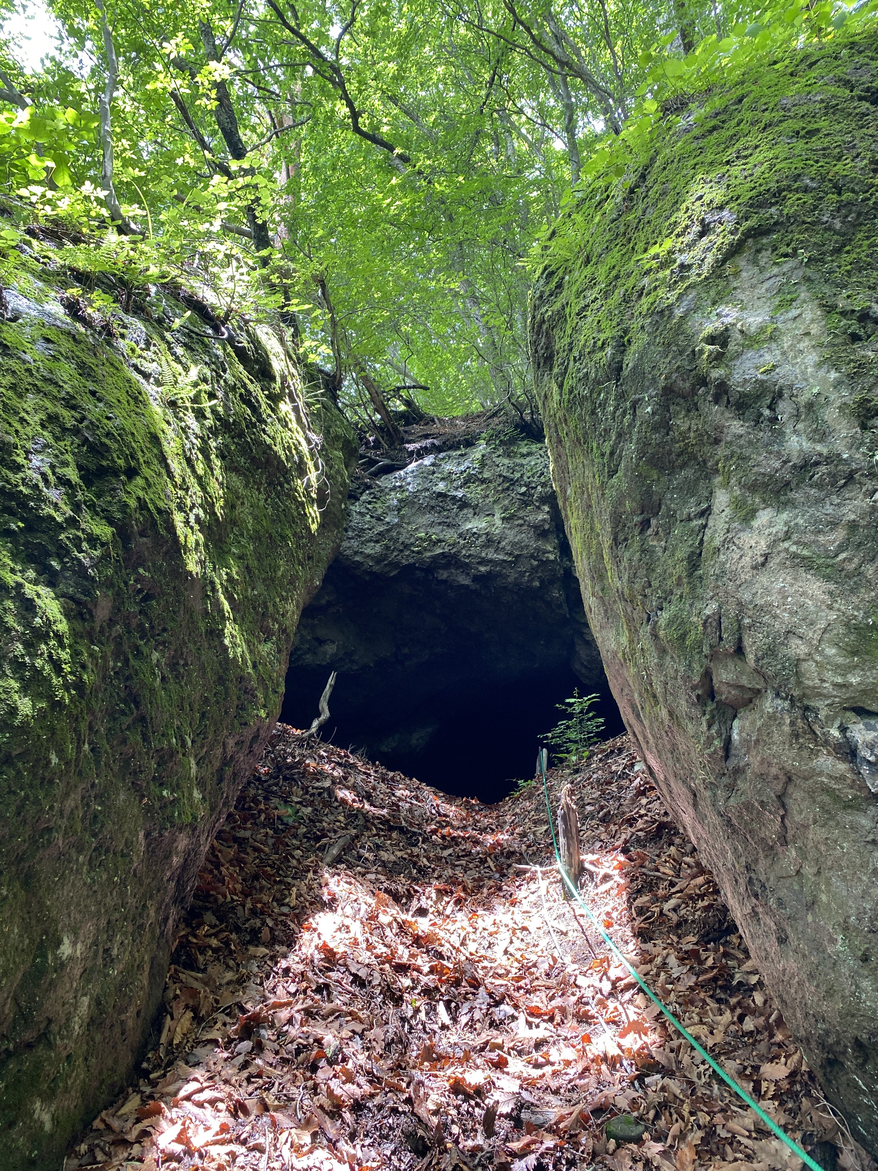
On the way to the cave . . .
Inside the cave, there are human and animal footprints. I wonder what goes on in there at night.
After dropping by the cave, I headed toward the peak and got my first views of the day.
Kengamine on the left, Mt. Asama on the right.
That post marks the top of Mt. Sekison.
Looking east toward Gunma and beyond. Mt. Myogi is in the picture. So it Ryokami and Toridani.
Facilities: Nothing
Thoughts/observations/recommendations: One thing I liked about this hike was that it was pretty secluded. Karuizawa is a happening place but I only bumped into two groups of people on my hike. I had the peak to myself.
Bring bug spray. I had planned to pick some up at 7-11 but they didn't have any. There weren't mosquitoes but there were giant bugs with swept-back wings. I am pretty sure they were horseflies. If you stand still they'll land on you and give you a painful bite.
I had the pleasure of Mrs. Caveman's company for (some of) this trip. While I was hiking, she was sketching at the Wild Bird Preserve. Check out her blog here: Put Out Into The Deep
On the way home, we dropped by the Shiraito ("White" "Thread") Falls and the Ryugaeshi ("Dragon" "turn back") Falls.
Shiraito Falls
Ryugaeshi Falls
That's all for today. Stay safe. Subscribe, blah blah blah. Or not. That's OK, too.
Do check out Mrs. Caveman's blog. It's worth reading.