I made a couple excursions this week. I didn't deem either trip blog-worthy at first but have changed my mind because today's weather is miserable and I have nothing else to do right now.
Don't you feel special now?
In all seriousness, I think relating these two trips could be useful to some of my readers who want day trip ideas in western Tokyo.
The first trip was hikeling around Akiruno and Hinodemachi. I took my bicycle from home through Akiruno and Hinodecho to a forestry road (林道) off Route 184 near the Tsurutsuru Onsen.
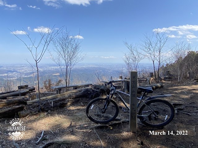
My initial plan was to ride to the trailhead, hike to Mt. Aso and then return to the bicycle and go home the same way I came. When I got to the top of the forestry road, I decided to just take my bike with me up to Mt. Aso. I know the trails there and I already knew that, even though I would have to carry or push my bike a bit, it isn't too extreme. This is the top of the forestry road. It is steep, as you can see.
The top of Aso. It has nice views of Tokyo on a clear day.
Since I made it up to Aso, I decided not to turn back but to keep going on the ridge down to Mt. Konpira, which is not too far from Musashi Itsukaichi Station. The ridge trail to there is also not so extreme and I know that there is a bike path to the top of Konpira from the street.
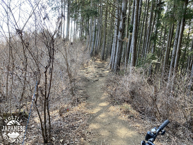
Some of the trail is like this:
Some of it is steep. When I got to Konpira, I decided not to descend on the path I know but to descend on the path down to Shonakano (小中野) because I'd never been down it. I am glad I was going down because this was a fairly rugged hiking trail and I had to carry my bicycle all the way.
This last pic is from that final stretch. I wish I had a better example picture for that part because it was quite steep and characterized by tree roots and boulders.
That's all for now. I hope that might give you some ideas.
Hello all you spelunkers. Welcome back to my mancave.
Today I made my 3rd trip to a mountain I look at all the time. When I look south from my neighborhood, I can see the Tanzawa Mountain Range in the neighboring prefecture of Kanagawa. The last mountain on the left before the terrain drops off precipitously to the sea is Mt. Oyama, (大山)--"Big Mountain." It's got a great nearly symmetrical cone shape--almost like a pyramid.
It's a nice mountain. Most trails can get you to the top in just a few hours. There are a lot of touristy things along the way, many temples and shrines, and some awesome views of Sagami Bay. Today I went up from that touristy side. In the past, I went up from the west side and had a more natural experience.
I started at the Isehara Shiei Oyama Daini Parking Lot near the Oyama Information Center. That's about a 15-minute walk to the cable car. I took my bike, but there are buses to this place.
This is what my trail for the day looked like. It was about 10km and took me a little over 4 hours. It's a bit steep so the change in elevation was nearly 1,200 meters.
If you want to see my avatar do it, head over to youtube.
There are lots of souvenir shops, restaurants and ryokans (Japanese-style inns) lining the road up to the cable car.
To keep you distracted from your aching feet, they pose quiz questions on the way.
Soon after I left the pavement, I ran into this guy eating leaves like a boss. He did not give me two thoughts. Check out his video on youtube, too. He's an influencer.
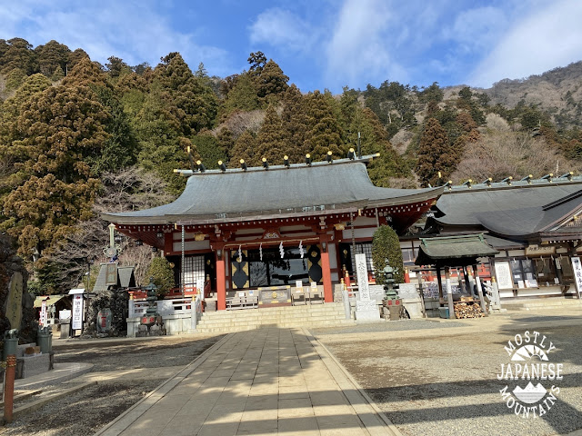
Just above the top cablecar station is the Afuri Shrine Shimosha. There is a spectacular view from here. Unfortunately, it was overcast.
This picture is from the top of the mountain on the west side looking at the Tanzawa Mountains. I love this sign. It's one of the few maps on the ground that are oriented in the direction they are pointing. It was super-easy to interpret. I didn't take any other pictures from the top because it was overcast and because there was a lot of construction going on to spruce the place up for the coming hiking season.
I LOLed when I saw this sign. "Fudou ziri" translates to something like "un-moving ass." Haha.
Looking at Sagami Bay on the way down.
This place is called "Miharashidai." Miharashidai means viewpoint or overlook and I made a special detour to drop by this place expecting a beautiful view. No such luck. Don't feel you've missed out on anything if you go to Oyama and give this place a pass.
Another temple I passed on the way down.
This place must be nice to see at night. All those lamps had light bulbs in them. I'd like to see it lit up because I've never seen any of those stone lamps lit up before.
Spring is almost here!
This isn't the best season for Oyama. It is a great mountain, however. If you're into looking at temples, you'll enjoy this. I'm not actually too much into temples because I'm Catholic. I do appreciate the aesthetic beauty of the Japanese sense, though.
Cherry blossom season and fall here are stunning.
It's not that strenuous. Personally, I don't think it's strenuous at all but I hike all the time. I have a co-worker who hiked this once and, to hear her talk about it, it's Mt. Everest, K2 and the Eiger all wrapped into one. (I hope she doesn't read this. In that case, forget what I just said. It is really an impossibly difficult feat to climb this. No one has ever done it without oxygen and sherpas.) It is a little steep but there aren't too many chains. No ladders. There are a lot of stairs. If you want just an easy day trip, you could just take the cable car to the Amefuri Shrine and not hike up to the top. The top is another hour or hour and a half hike from there.
I don't think it would be proper to say spring has sprung yet, but it is certainly coiled and ready!
Yesterday was a national holiday and I spent the night before planning and prepping for a long hike to a high, cold, snowy mountain. My plans were dashed near the end of the night when I realized that one of the trails I'd planned on using was closed. I had to pare back my plans. When all was said and done, hikeling to a nearer mountain made the most sense. I took my bicycle to the area behind Mt. Takao and headed up Mt. Kagenobu. This was probably my 3rd or 4th time there.
This was my bike route:
I rode along the pavement past the last bus stop. That is the Kobotoke Bus Stop which is a 27-minute ride from Takaosanguchi Station on the Keio Train Line. There is a parking lot a bit further down the road near the trailhead.
When the pavement ran out, I rode up the logging road/hiking trail . . .
. . . until ice and snow made that untenable. Then I got off my bike and put on my crampons to hike the mile or so left to get to the top of Kagenobu.
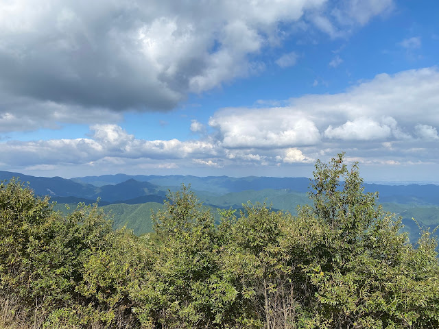
Kagenobu, similar to its neighbor Takao, offers great views--without the crowds of people that gather on Takao. This is Tokyo in the picture below.
I think this was the first time I've been up there that these places have been open. They serve food, drinks and sell t-shirts and the like.
They aren't in evidence in any of the pictures that I'm posting but there were a lot of people on the trails yesterday. I think Tokyoites are itching to get outside more.
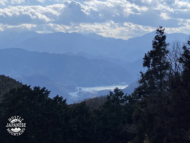
Lake Sagami in the adjacent prefecture, Kanagawa.
Some of the hills of Kanagawa:
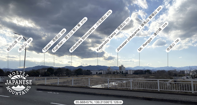
On the way home. Looking back where I'd been. I think this was a bridge over the Asakawa (Asa River).
Thanks for dropping by the cave.
Keep your fingers crossed. I'm really hoping go overnight somewhere while there's still snow.
Also featuring Dayan the Cat and bowls of steaming noodles
Tonight's Episode:
Searching for Nessie
Greetings cave-dwellers. This post will be a little bit different than others. For this excursion, I had Mrs. Caveman with me. What a treat. She's more fun than a sherpa! Better-looking, too. Truth be told, though, Sherpas will carry more of your stuff but what can you do? You can't have everything you want in life.
As I was saying, me and the missus took a day trip to Kawaguchiko (Lake Kawaguchi) to take in some views of Mt. Fuji. Even though winter is one of the four best seasons to see Mt. Fuji, this is the off-season so it was a win-win because we had the place to ourselves.
There are many ways to get to this area. For us, the cheapest and easiest was to catch the highway bus that runs from Shinjuku to Kawaguchiko Station. We didn't have to go to Shinjuku because we could catch it on the highway along the way. Here is a link to the bus company's website. http://bus-en.fujikyu.co.jp/highway/ You can also get there by train. To do that, you would change to the Fujikyu Railway at Otsuki and head toward Kawaguchiko Station. (These methods or transportation will get you to Fuji Q Highland Park too.)
Here is where we alighted the bus. This station is also the departure point for the bus to the 5th Station on the Subaru Line for climbing Mt. Fuji.
(No Nessie there.)
From there, we walked about 10~15 minutes to hop on this ropeway up to Tenjoyama Park. The ropeway is a 3-minute ride and costs ¥900 roundtrip. You also could walk up to the park but the Missus and I have decided not to discuss that anymore. The ropeway also offers package deals combining their fare with the various buses and trains running in the area. We bought roundtrip ropeway tickets combined with a train ticket to Otsuki Station for our return home.
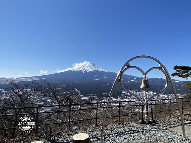
These pictures are from Tenjoyama Park. There are (of course) a giftshop and snackbar up there.
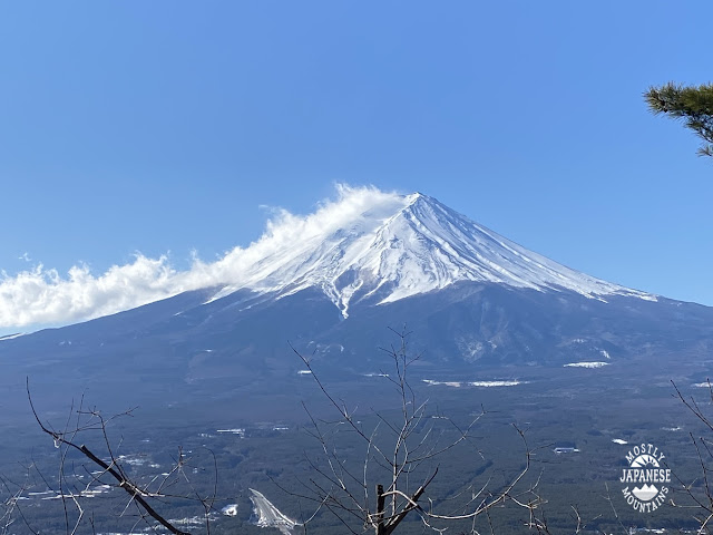
That mountain below is what brought this trip about. My plan to climb it last week was thwarted by a large dump of snow the night before I was going. So, my solo hiking trip morphed into a date with my better half.
(Is that Nessie under the bridge?)
(No. Still no Nessie.)
Sakasa (Upside-down) Fuji
(Obviously, Nessie was here. What else might have stirred up the water to disturb the reflection?)
The local delicacy is called Hoto, a hearty dish with thick, udon-type noodles. This restaurant is called Fudo Hoto (不動ほうとう) and has two branches on either side of the lake. It was yummy.
Notice the shape of the condiments containers.
There are lots of places serving hoto in the area but this one was the most advertised and also happened to be the only one open. Its good reputation is obviously well-deserved. Not only do they serve hoto, but you can get basashi. (Look that up in a dictionary.) Their website: http://www.houtou-fudou.jp/english.html
The one drawback? They don't serve Nessie.
It's always Christmas at Lake Kawaguchi! It's just like the North Pole or the Philippines!
Mrs. Caveman posed at the Kawaguchiko Craft Park with the owls. She's a looker so she's used to a lot of hooting.
We didn't do anything at the craft park other than taking a few pictures. They offer lots of craft experiences, rent bicycles, have a restaurant or two. . .
. . . and they have a lot of owl carvings! I think the guy in charge of wood carving learned how to make an owl and then stopped studying. There are owls everywhere but nothing else.
He most definitely never learned to carve Nessie.
One other place we dropped into gets no pictures! That's their fault. The Dayan Cat Museum didn't allow pictures. http://www.konohana-muse.com/indexenglish.html
That place wasn't really my cup of tea. We only went there because the Fudo Hoto restaurant gave us coupons for cheap entry and a free drink. Their coffee and their restaurant were top-notch. Too bad we were already full from eating the hoto.
I'll be back for those another day. Maybe Nessie is up there?
That's all for now. I'm on my way out the door to go hikeling now. I'll probably blog about that later if anything interesting happens.
I hiked in Saitama and Tokyo a bit today. The skies weren't clear enough for any good views, but fairly fresh snow and empty trails made for a nice day.
Crampons were a necessity today.
Here's my trail today.
I started at a parking lot near Nagurigawabashi and hiked up to Bonorei (Mt. Bono). From there, I hit three or 4 more peaks before the last one, Mt. Iwatakeishi. From there I descended to Route 202 and then walked along Route 53 back to where I'd parked. I walked about 5 km on the pavement today, 16km in total.
The hike took a little more than 6 hours. The snowy parts were slow. The pavement allowed me to make up time.
I don't have anything super-beautiful or insightful to share so I'm tempted not to blog about this hike but have decided to just to give the information about the trails.
This was my starting point near Nagurigawa Bridge. There is a bus stop nearby. I'd assume the bus comes from Hanno.
A shrine by my departure point.
The beginning of the trail was paved.
I liked this rock.
Leaving the road.
This boulder is called Iwatakeishi. Not to be confused with Iwatakeishi Mountain which I'd climb around noon. This is where I put on my crampons. I needed them for the next 4 hours or so.
Today's highest point was Mt. Bonorei. Here are some pictures of it from today and from October.
Today
October
Another spot today
The same spot as the last picture. I think this was in October.
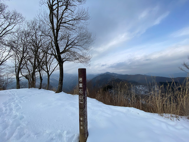
Mt. Iwatakeishi. It was standing-room-only last time I was here.
Basically the same spot last April.
On the way down.
This cafe is popular with bicyclists. It's at the beginning of a hill that bicyclists ride up for training.
I don't like to descend the same way I go up that much so I often will hike in a circle. This sometimes means I need to close the circle between different trailheads by walking along the road. Today was one of those days. I don't mind it that much. I'm still walking in the woods.
That's all for today. Drop by the cave again sometime.