Showing posts with label Fuji View. Show all posts

Just . . . Lake Shoji area dayhike #Skywatch Friday


Greetings cave dwellers.

For the emperor's birthday holiday this week, I went to Lake Shoji, the smallest of the Fuji Five Lakes.  This is one more leg in a long project of hiking the mountains on the shores of all five lakes in an unbroken line.  I've completed most of the western four lakes.  I have more work to do on Lake Ashi to the east.


Location:  Panoramadai

Starting and stopping point:  Bus Stop below Panoramadai パノラマ台下バス停

Mountains climbed: Panoramadai (パノラマ台)  Shoji (精進山) Sanpobun (三方分山) Goko (五湖山) Yokosawanoto (横沢の頭) Seiya (西精山)

Getting there/getting around:  This is accessible by bus on the blue line from Kawaguchiko Station or Fujisan Station.  There are very few buses and it's a long ride.  There is a free parking spot right next to the trailhead where I parked my scooter. 

Map:  Yama to Kogen Chizu 32 FUJI-SAN MISAKA・ASHITAKA-YAMA 富士山 御坂・愛鷹山

Weather Information:  Mt. Sanpobun weather

Total Time:  6  hours 44 minutes   Break time:  36 minutes

Distance:  15.4km

Elevation:  Lowest:  900m Highest: 1,465m Total Ascent: 1,345m Total Descent: 1,345m

Technical considerations/difficulty:  Not a terribly technical hike.  Not much exposure.  It's all well below the treeline.  There is little in the way of chains or ropes.  There are steep parts and there are some parts of the trail that have been washed away in landslides.  There hasn't been much snow this season and I didn't even bother to put on my crampons.

Facilities:  Nothing on the trail to speak of except for a sheltered picnic bench at the panoramadai.

Thoughts/observations/recommendations: 

I've said it before.  There is a certain world-famous brand name that I don't patronize because--well I won't go into their myriad of offenses here.  I won't buy their products but I do begrudgingly agree that their slogan is great.  Just Do It.  Yesterday was another day when Just Doing It paid off for me.  I had the day off and wanted to get a day of hiking in but the weather didn't look great and the futon was mighty warm and cozy at 5:00 am.  And . . . the plan for the day entailed riding my scooter 3 bone-chilling hours before even starting a long day.  The prospect of a long, cold grey day with no worthwhile views made me wonder if the risks didn't outweigh the possible rewards.

The sky matched my grey mindset for the entire 3 hours I spent on the road out to the foothills of Mt. Fuji.  I usually make the ride non-stop.  On this trip, I stopped 3 times to warm up.

Then, just as I reached my destination, the sky cleared up and the temperature rose a few degrees.  Once again I was glad that I was Just Doing It.

I never regret Just Doing It.  Sometimes I stop doing it when something is stupid or dangerous--but that is something different.

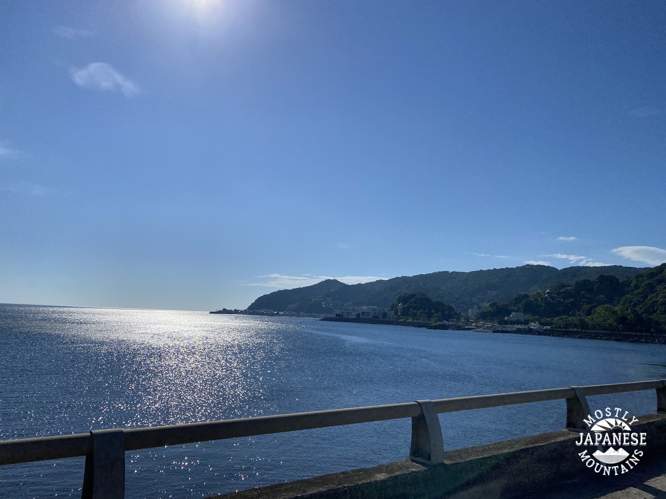
The place:  As Lake Shoji is the smallest and least developed of the Fuji Five Lakes it is a sweet spot to visit.  It's not really easy to get to for a day trip so there are fewer tourists than on the other lakes.  There are only a few hotels and restaurants.  One hotel has campsites on the lakeside.  The panoramadai and the lakeshore have the best views.  I did see on one of the billboards for a hotel that they have a rotenburo (露天風呂--outside bath) with a view of Mt. Fuji.  That would be cool!  If I weren't such a cheapskate, I would try it.  For my purpose of tying up the loose threads between this lake and Lake Sai to the east, I hiked far to the east to Mt. Yokosawanoto.   If your purpose is a pleasure hike with nice views, I think you should skip about half of my plan.  I would recommend going to the Paroramadai before heading northeast to Mt. Sanpobun and finally descending down to the lake from there.  That portion of my hike was where all the best views were.  The last several hours of my hike were not the most photogenic.


This is what the map looks like:


Let me show you some pictures.

Remember what I said about access to this place being difficult?  Check out the bus schedule.  It's a long wait if you miss a bus!


The trailhead to the Panoramadai

Fuji sometimes forms lenticular (lense-shaped) clouds.  When they are directly over the mountain, they are called kasagumo--"bamboo umbrella-cloud".  When they form to the leeward side of the mountain, they are called tsurushigumo--"roll clouds".  I think these must be tsurushigumo.


Looking west from the Panoramadai.  That is Lake Motosu--the western-most of the five lakes--down below.  My last trek on this side of the lake region will be to circumambulate that lake.  Lake Motosu has a massive tranquil campground.


Mt. Omuro is directly in front of Fuji in the next picture.  I climbed that from the south side of this lake in August.  That is in the Aokigahara Forest.  That has a sad reputation for being a suicide destination.


This is where I exited the woods at the end of my trek.  The trail I used from Mt. Goko down to the lake is a secondary trail and doesn't appear on all maps.  You can get an idea of the condition of the trail by the condition of its entrance.  That rickety wooden thing in the middle of the picture is a stair/ladder.


What a sight to be presented with when walking out of the woods.


I got a kick out of being able to spot the buildings of the 5th Station from 10 miles away.


I couldn't get enough of this view.


On the way home . . .


From the Narusawa area


3 lakes later . . .


That's all for now.  Have a great day.  Don't forget to subscribe if you haven't already.  The button for that is in the pop-out menu on the right.  
Leave a comment, too.  I love those.


ps  Check out other blogs with pictures from around the world at   https://skyley.blogspot.com/


Izu Peninsula Mt. Amagi One of Japan's 100 Famous Mountains.


I had Monday off this week.  I decided on a trip that would allow me to make the best use of that long June day.  I headed down to the Izu Peninsula, to Mt. Amagi, one of Japan's Famous 100 Mountains.   (Mt. Amagi=天城--"Heaven Castle")  It's a hike I've wanted to do for a while but have put off because of the distance.  It's not a challenging hike and it's far so it's hard to justify the time and expense.  The usual train/bus route costs over ¥5,500/about $45 and takes 4.5 to 5 hours each way.  I opted to go on my scooter.  That also takes a long time but would cost about ¥700 in gas.  Despite the savings, the drive time had me worried.  Googlemaps gave an estimate of between 3.5 and 6 hours each way.  Assuming the longer estimate was correct, I could be looking at 12 hours crouching over my moped.  Yikes.

I decided to roll the dice and take my chances.  I got up at O dark thirty and left home an hour later at sunrise.  (4:30 these days.)  Even though it's far, the ride was worth it.  The ride actually gave me the best views of the day.  On the way I caught a glimpse of the top of Odawara Castle while passing through Odawara.  The Izu coast around Atami and Ito were gorgeous.  Coming home, I took the inland route which brought me under Fuji's gaze around Gotemba.  I always wonder "Am I the only one who sees the giant eye on the top of Fuji?"  I was able to enjoy dinner on the shore of Lake Yamanakako at sunset.  That was beautiful.


These first several pictures are of the ride down.   Izu is one giant playground.  The ocean is beautiful, as you can see.  There is surfing, fishing, boating--but also golfing, and hiking.  Its hot springs are quite famous because it is a very active region geologically.  It would be a nice place to spend a week or so if you had a suitcase full of money.


Here are the details of the hike:
Getting there:  Whether coming by bus or by their own car, most people start hiking at the Amagi Juso Tozanguchi Bus Stop which is adjacent to the Amagi Kogen Golf Course.  You can get there by bus (about 1 hour) from Ito Station.  You can get to Ito Station from Tokyo on the Tokaido Shinkansen.  There are cheaper local trains but they will take longer than the shinkansen.

Facilities:  At the bus stop, there is a free parking lot for hikers equipped with public toilets and water.  The only food nearby I saw was protein bars in the clubhouse.  There is a vending machine for drinks there, too.  Water is ¥210!

The hike:  It's not very strenuous.  There are actually several peaks that comprise Mt. Amagi.  There is Banzaburo , Banjiro and Togasa.  Most people just do Banzaburo and Banjiro.  They are accessible on a loop trail that passes near the golf course.  One side of the loop is the shakunage (シャクナゲ=rhododendron) trail.  I'm not really a fan of hiking near rhodos, but I'm sure it floats some people's boats.

The loop takes about 3~5 hours.  It's about 8km.  The rise in elevation isn't that great.  Maybe 700 meters?

I did that loop and also added in Mt. Kotake.  It wasn't that far and I'm always happy to bag another peak.  After that, I also added Mt. Togasa to my hike.  Most people ignore it because it is about a mile or so down the road from the golf course to its trailhead.  I am glad I did it.  There is a wireless relay station at the top so there is a mostly-paved road all the way to the top.  Also, I got my best views of the day from there.  

My day ended up being 16.3 km which translates to just over 10 miles in American.  I went up and down 1,140 meters in elevation.  

The parking lot/bus stop I mentioned is annotated as the Amagi Kogen Golf Course.  I didn't park there.  I parked just above the uppermost fairway on the map below.  You can see a little blue triangle there.


Before I get to this day's hike, here is a picture or two I took of the area from Mt. Fuji.  


These are from the trail:

Sagami Bay is on the left side of the picture.


. . . and looking back.


These are from Mt. Togasa.  Unfortunately, the bay wasn't so visible by this time of day because of the haze.  It was hot.  36 degrees Celsius at sea level.


More on this later.


That Mt. Omuro looks cool!


The relay center on Togasa


Happy puppies.


Oh, I should mention the badge.  This is kind of like a participation trophy.  (That I buy for myself.  How pathetic.)  Many of the popular mountains produce a commemorative pin that you can buy.  I try to buy one every time I climb one of the 100 Famous Mountains.  I have a big banner that lists all of the mountains and I attach the badge to the banner each time I get a new one.  I'm such a geek caveman. 

This is the one I got yesterday. 


If you want to climb a mountain that has badges.  Make sure you find out where they sell them ahead of time--or at least before you leave the mountain.  I found out the hard way that if you don't buy them near the mountain, you're out of luck.  There is no one manufacturer that handles all of them.  You can't order one on Amazon or something like that.  Usually, they are only available at one vendor near the mountain.  If you don't get it there, you are out of luck!  The ones for Amagi are sold in the clubhouse.

Some thoughts about this trip.  I'm glad I went.  I am not a fan of Nike, but I do love their slogan.  As with most of these things I waiver about doing, just doing it has brought results.  I've never regretted going for a run in the rain or taking on a mountain that pushes my limits.  (I'm not above turning back when things are dangerous though!)

I did this hike during an off-period.  The best months to climb Amagi are May, early June, and October.  Those periods have the best flowers, the best views of Fuji and the ocean and/or fall foliage.
They also have crowds.  There are trade-offs.  On my return, it was really cool to be the only person on Lake Yamanaka.  On the other hand, none of the restaurants were open and I almost ran out of gas because the one gas station on my way was closed.  (Actually, they had just locked the door--5 minutes early--when I pulled up.  But that post is reserved for a review on googlemaps!)


That's pretty much it--except for the ride home.  I got some great views of Fuji on the way.  When all was said and done, I rode about 300km and the trip took me just over 16 hours. 

These are from Lake Yamanaka


Drop by my cave anytime.