Not particularly easy. Getting there by public transportation takes a while and a few changes. I rode my scooter. The boats and ropeways are used by a lot of people. See here for a run-down Hakone guide
Map:
Yama to Kogen Chizu #??? Beats me. I just used my smartphone this trip. Not the best practice to go without paper but it's kind of hard to get lost next to a giant lake with the largest mountain in the country and the largest ocean in the world as landmarks.
Lowest: 727m Highest: 1,202m Total Ascent: 1,061m Total Descent: 1,056m
Technical considerations/difficulty:
Very straightforward hike. Well-maintained trails. No chains or ladders. It's Japan so there are steep spots that will get your blood pumping but nothing dangerous.
Facilities:
The trail I took parallels a road and there is a michi no eki on the way. Public restrooms are located here and there.
When you get to Owakudani and the area where the boat passes, there are all the tourist amenities you could wish for.
Thoughts/observations/recommendations:
This is a really, really nice area. The volocanic activity in the area make for more hot springs than you can shake a stick at. The accommodations are really world class, the scenery is wonderful and there is historical (the checkpoint of the old Tokai road to Edo in the feudal era) as well as contemporary (ekiden popular relay race) significance. The only drawback is the distance and time necessary. The time it takes to travel there makes Hakone a stretch for a day trip. It can be done, but it would be better to overnight. The shekels necessary for a trip like that really add up, though. First, there is the expense of getting there, then of staying somewhere, then for getting around there on the ropeways and boats. Yikes.
I am sorry, but the Caveman is super busy today. Mrs. Caveman and I are relocating to a new cave in a few weeks and I need to get moving if we're going to move. I will probably not make this a terribly detailed post in order to save time. I just wanted to make anyone interested in hiking around the lake aware of what I did as a plan. If you're interested in the area, you can contact me or ask the google machine.
On the way to Hakone, I passed through Odawara and dropped by the Odawara Castle.
I was on the trail by 8.
The Minami Alps in the background on the left.
I had lunch by the lake.
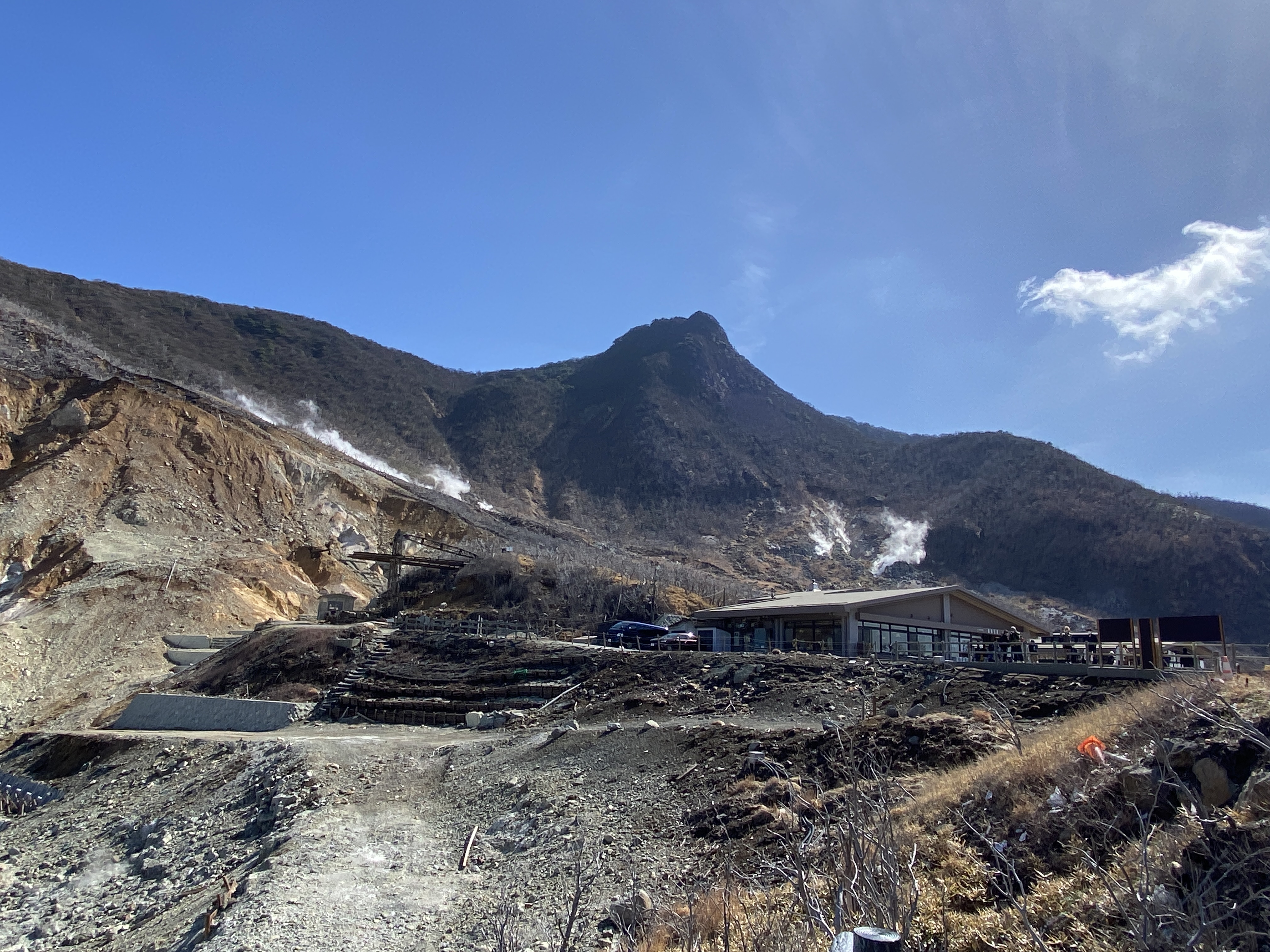
My plan was to hike all the way up to Owakudani. I was really unhappy to find the trails closed from halfway up. I had to take the ropeway. The prices nearly put me off. The caveman is a cheapskate and likes to walk.
Owakudani is cool! The sulfur smell was strong at times.
This picture doesn't really give a sense of how packed the souvenir shops were. There were a ton of people at Owakudani; many if not most of them foreigners. It sounded like the U.N. up there. For me, after a nice bucolic morning in the woods it was sensory overload. I wanted to get back into my cave.
The most popular item for sale is black eggs. Owakudani black eggs Those are eggs boiled in water with a content of sulfur and iron.
The guy selling black eggs in this picture reminded me of a famous episode of Seinfeld. I think of this guy as the "Egg Nazi". All he does is sell eggs. Someone brought another souvenir to his register hoping to purchase it and was told, "No souvenir. Only eggs here!"
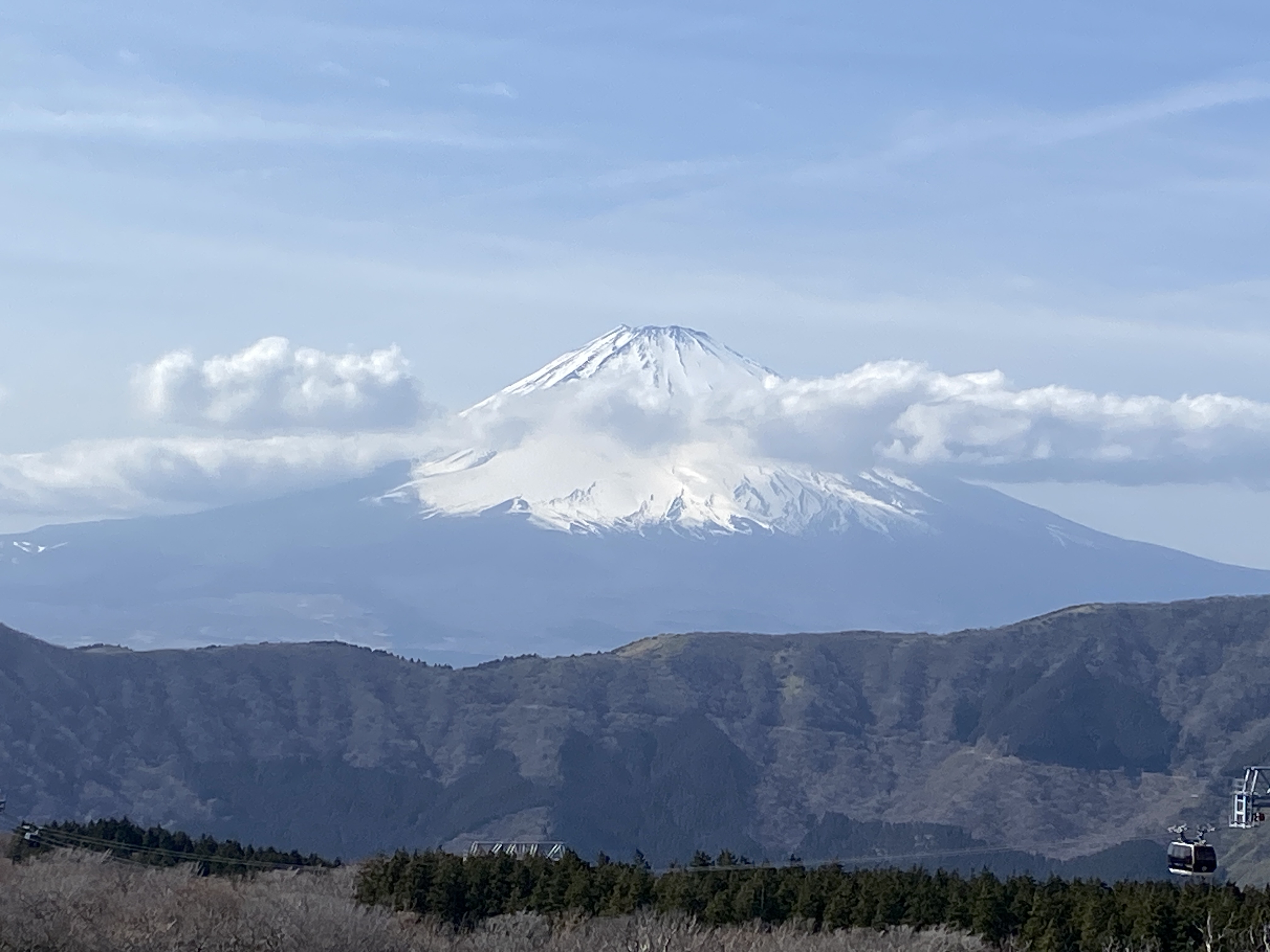
This was taken from the ropeway. Mt. Kintoki is a mountain I did on another trip last July. I highly recommend it.
From the boat back to where my bike was parked.
OK. That's it. Thanks for dropping by the cave. I don't know when I'll be blogging again, but I will sometime. The little woman and I are moving to the mountains!
Want to see the place where the legendary Kintaro was born? Mt. Kintoki
How about another 100 Famous Mountain in the Fuji Hakone Izu National Park? Mt. Amagi
Greetings cave dwellers. The caveman here. Welcoming you back to another spelunking episode. Hope you have your helmets and headlamps on because we're dropping into my cave.
I'm taking advantage of the long summer days while they're here to travel farther and take longer hikes than I can the rest of the year. Yesterday was my 4th (maybe 5th?) venture to Shizuoka in just the last month or so. It's about a 3-hour-ride each way for me to get down there. My backside is sorer than my feet but it's been fun to see some new places. Shizuoka is really a playground. If you like nature, fishing, golfing, onsens, you're sure to find something you like down there.
Yesterday, I went to Mt. Ashitaka, in Japanese, 愛鷹山,--Ashitakasan. It's called "san", mountain, but the "san" is actually kind of a mountain range composed of several "take"* or "dake"--another word for mountain.
*pronounced "tah kay" or "dah kay"
Here's the lowdown. Mt. Ashitaka is a volcano and the name for the elevated general area is Ashitakasan. The individual peaks are named and called "take" or "dake". "Take" means something like sharp, pointy thing sticking up out of the ground pointing at the sky.
Forgive me for continually digressing, but there are actually many words for mountain. "san", "yama", "take", "dake", "mine", "rei", "gaku", "maunten" . . . and they all have different meanings. Trying to understand them is a bit like trying to understand the whiskey vs. whisky or Scotch vs. Scottish arguments. At a certain point, I just give up caring. I've seen some virtual fisticuffs online about things like whether Mt. Fuji is pronounced "Fujisan" or "Fujiyama." That gets tempers flaring even more than disputes about the ratio of sheep to humans in New Zealand.
I don't have the energy to fight. When these things come up, I just grab my popcorn and watch.
Anyway, as I was saying . . . Mt. Ashitaka. Lovely mountain. Unfortunately, the weather wasn't the best. I had clear skies in the morning, but most of the best viewing points were fogged in while I was there. I'll have to get back in the fall or winter.
Parking for 30 cars there. Fujikyu Buses come from Gotemba in 30 minutes. The Fujikyu City Bus from Mishima takes 51 minutes.
Map:
Yama to Kogen Chizu #32 富士山
Weather Information:
This is a Japanese link but you can see the weather report graded for climbing in 3 hour increments. "A" is best. "C" is worst. Weather for Ashitaka
Distance:
14.5km (about 9 mi.) Took me about 8 hours.
Elevation:
Minimum: about 750m, Maximum: 1,504m Total elevation climbed: 1,636, descended: 1,631
Technical considerations/difficulty:
There are some fairly steep spots. Looking at the statistics distance and elevation of this hike, I found it interesting that this hike was more arduous than the one I made up Mt. Fuji last week. I first climbed up to Mt. Ihai. There is a steep ascent up to the top with a lot of ropes. Throughout this area, there were a lot of ropes and some narrow ridge walks. In a few places there were rickety-looking ladders but they were stable enough. Quite a bit of the area going up to Wariishi Pass (割石峠), is scree. You must be confident with a map and have a good sense for the trail because you really have to be able to almost sniff out the next red ribbon marking the trail. The scree area could be concerning in very heavy rain.
Two of the peaks are inaccessible these days due to rock slides. I wanted to climb them but will have to come back another day.
Facilities:
There is a porta potty at the parking lot. If you need water or food, bring it with you because there is nothing on the trail.
Thoughts/observations:
Really top-notch views of Mt. Fuji to be had here. I got some spectacular peeks at Mt. Fuji and the surrounding ski areas, military training areas (Japan Self Defense Forces and USMC), and other things on its south side. Mt. Hoei and its volcano crater on that side of Fuji, is so cool. Unfortunately, the weather turned early in the day and I can only guess how beautiful the view of Suruga Bay to the south of Mt. Ashitaka might be. Like I said, I'll have to go back when the weather is better.
You could make this a much shorter hike than I did. If you're not into straining too much, you could just go to Kurodake from the parking lot and be done in just 3 or 4 hours--but still get a great view.
Trivia:
Japanese mountain names are interesting and sometimes infuriating. There are so many mountains, that many of them have the same name. Case in point is this hike's Kurotake, "Black Mountain". There are too many Black Mountains to count and there are many "Round Mountains" and "Big Mountains", etc. One of the peaks on this hike is 位牌岳 ("ee high"). I had to look up eehigh in the dictionary. It means "Buddhist mortuary tablet."
Let's close out by looking at some pictures. I'll start by showing some pictures I took from Mt. Fuji last August.
Mt. Hoei, that I mentioned before, is the bump in the middle foreground of the next picture. The dark spot on the right is the top of its crater.
Mt. Echizen is to the right side of the picture. Behind that is Banzaburo. I climbed that the day I climbed Mt. Amagi earlier this summer.
Mt. Echizen is actually higher than the mountain behind it. It just looks smaller because of the perspective.
This is a nice picture but it's kind of cheating. I took it by Lake Yamanaka on the way home.
Drop by again soon.
Make sure you subscribe before the available subscriptions run out.
Leave a comment and ¥5,000 and I promise Mr. Umanami will deliver a slice of pizza to you. Either that or he will at least deliver a smile. That's what he does. As he says, he delivers surprise and smiles to mountaintops. He is the king of delivery!
「山頂まで「驚き」と「笑顔」を
デリバリーしています。
配達王に俺はなるっ!」
How about another 100 Famous Mountain in the Fuji Hakone Izu National Park? Mt. Amagi
Want to see the place where the legendary Kintaro was born? Mt. Kintoki