Showing posts with label 100meizan. Show all posts

Caveman hikes Mt. Amagi, one of Japan's 100 Famous Mountains.


I had Monday off this week.  I decided on a trip that would allow me to make the best use of that long June day.  I headed down to the Izu Peninsula, to Mt. Amagi, one of Japan's Famous 100 Mountains.   (Mt. Amagi=天城--"Heaven Castle")  It's a hike I've wanted to do for a while but have put off because of the distance.  It's not a challenging hike and it's far so it's hard to justify the time and expense.  The usual train/bus route costs over ¥5,500/about $45 and takes 4.5 to 5 hours each way.  I opted to go on my scooter.  That also takes a long time but would cost about ¥700 in gas.  Despite the savings, the drive time had me worried.  Googlemaps gave an estimate of between 3.5 and 6 hours each way.  Assuming the longer estimate was correct, I could be looking at 12 hours crouching over my moped.  Yikes.

I decided to roll the dice and take my chances.  I got up at O dark thirty and left home an hour later at sunrise.  (4:30 these days.)  Even though it's far, the ride was worth it.  The ride actually gave me the best views of the day.  On the way I caught a glimpse of the top of Odawara Castle while passing through Odawara.  The Izu coast around Atami and Ito were gorgeous.  Coming home, I took the inland route which brought me under Fuji's gaze around Gotemba.  I always wonder "Am I the only one who sees the giant eye on the top of Fuji?"  I was able to enjoy dinner on the shore of Lake Yamanakako at sunset.  That was beautiful.


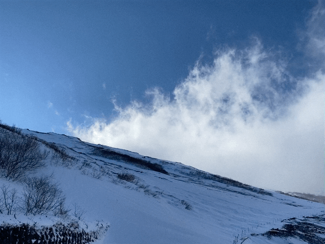
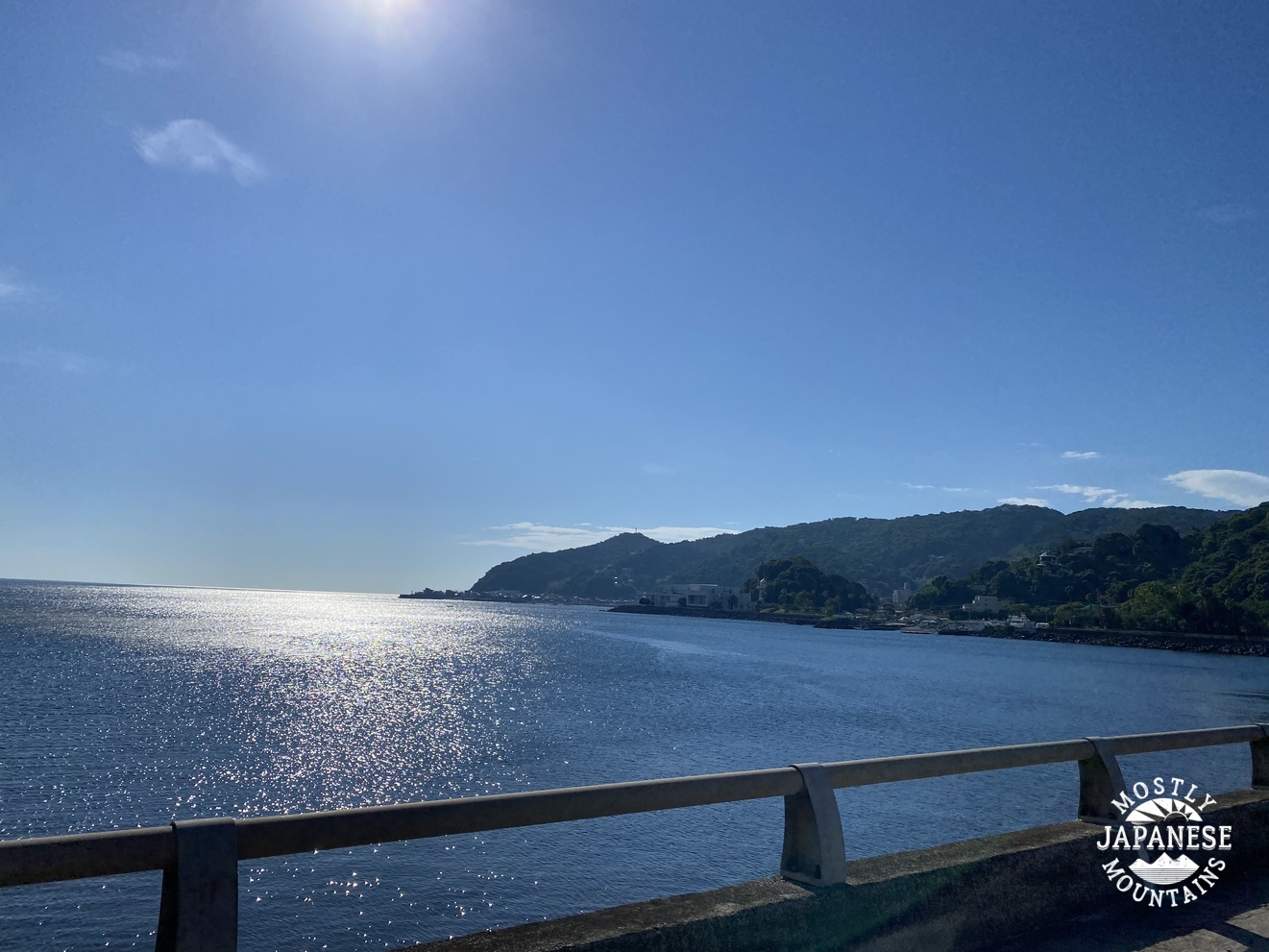
These first several pictures are of the ride down.   Izu is one giant playground.  The ocean is beautiful, as you can see.  There is surfing, fishing, boating--but also golfing, and hiking.  Its hot springs are quite famous because it is a very active region geologically.  It would be a nice place to spend a week or so if you had a suitcase full of money.


Sagami Bay from Izu

Sagami Bay from Izu  2

Sagami Bay from Izu  3

Here are the details of the hike:
Getting there:  Whether coming by bus or by their own car, most people start hiking at the Amagi Juso Tozanguchi Bus Stop which is adjacent to the Amagi Kogen Golf Course.  You can get there by bus (about 1 hour) from Ito Station.  You can get to Ito Station from Tokyo on the Tokaido Shinkansen.  There are cheaper local trains but they will take longer than the shinkansen.

Facilities:  At the bus stop, there is a free parking lot for hikers equipped with public toilets and water.  The only food nearby I saw was protein bars in the clubhouse.  There is a vending machine for drinks there, too.  Water is ¥210!

The hike:  It's not very strenuous.  There are actually several peaks that comprise Mt. Amagi.  There is Banzaburo , Banjiro and Togasa.  Most people just do Banzaburo and Banjiro.  They are accessible on a loop trail that passes near the golf course.  One side of the loop is the shakunage (シャクナゲ=rhododendron) trail.  I'm not really a fan of hiking near rhodos, but I'm sure it floats some people's boats.

The loop takes about 3~5 hours.  It's about 8km.  The rise in elevation isn't that great.  Maybe 700 meters?

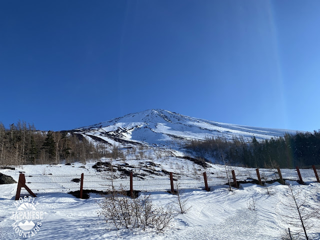
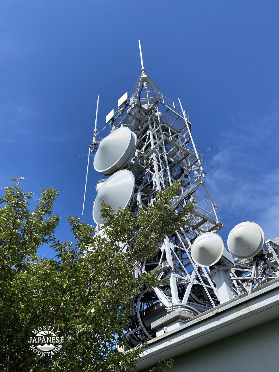
I did that loop and also added in Mt. Kotake.  It wasn't that far and I'm always happy to bag another peak.  After that, I also added Mt. Togasa to my hike.  Most people ignore it because it is about a mile or so down the road from the golf course to its trailhead.  I am glad I did it.  There is a wireless relay station at the top so there is a mostly-paved road all the way to the top.  Also, I got my best views of the day from there.  

My day ended up being 16.3 km which translates to just over 10 miles in American.  I went up and down 1,140 meters in elevation.  

The parking lot/bus stop I mentioned is annotated as the Amagi Kogen Golf Course.  I didn't park there.  I parked just above the uppermost fairway on the map below.  You can see a little blue triangle there.


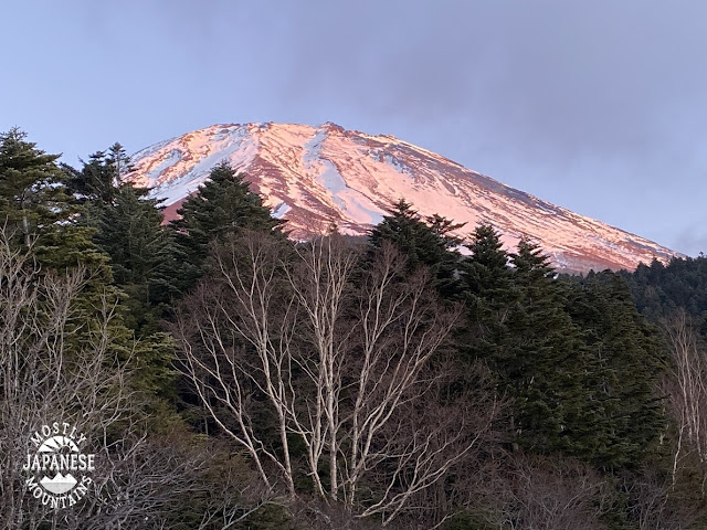
Before I get to this day's hike, here is a picture or two I took of the area from Mt. Fuji.  


Those last pictures were taken on this trip to Mt. Fuji


These are from the trail:

Sagami Bay is on the left side of the picture.


Mt. Togasa from Mt. Banjirodake

. . . and looking back.

Mts Banzaburo and Banjirodake from Mt. Togasa

These are from Mt. Togasa.  Unfortunately, the bay wasn't so visible by this time of day because of the haze.  It was hot.  36 degrees Celsius at sea level.

From Mt. Togasa


More on this later.


That Mt. Omuro looks cool!


Mt. Omuro in Izu


The relay center on Togasa
Togasa Relay Center


Happy puppies.


Oh, I should mention the badge.  This is kind of like a participation trophy.  (That I buy for myself.  How pathetic.)  Many of the popular mountains produce a commemorative pin that you can buy.  I try to buy one every time I climb one of the 100 Famous Mountains.  I have a big banner that lists all of the mountains and I attach the badge to the banner each time I get a new one.  I'm such a geek caveman. 

This is the one I got yesterday. 

Mt. Amagi Badge


If you want to climb a mountain that has badges.  Make sure you find out where they sell them ahead of time--or at least before you leave the mountain.  I found out the hard way that if you don't buy them near the mountain, you're out of luck.  There is no one manufacturer that handles all of them.  Usually, they are only available at one vendor near the mountain.  If you don't get it there, you are (almost) out of luck!  They are available on Rakuten or Amazon, but you'll have to search in Japanese.  The ones for Amagi are sold in the clubhouse.

Some thoughts about this trip.  I'm glad I went.  I am not a fan of Nike, but I do love their slogan.  As with most of these things I waiver about doing, just doing it has brought results.  I've never regretted going for a run in the rain or taking on a mountain that pushes my limits.  (I'm not above turning back when things are dangerous though!)

I did this hike during an off-period.  The best months to climb Amagi are May, early June, and October.  Those periods have the best flowers, the best views of Fuji and the ocean and/or fall foliage.
They also have crowds.  There are trade-offs.  On my return, it was really cool to be the only person on Lake Yamanaka.  On the other hand, none of the restaurants were open and I almost ran out of gas because the one gas station on my way was closed.  (Actually, they had just locked the door--5 minutes early--when I pulled up.  But that post is reserved for a review on googlemaps!)


That's pretty much it--except for the ride home.  I got some great views of Fuji on the way.  When all was said and done, I rode about 300km and the trip took me just over 16 hours. 

These are from Lake Yamanaka
Lake Yamanaka


Drop by my cave anytime.

Check this hike on Mt. Ashitaka if you want to see another hike on Izu.
 

How about another 100 Famous Mountain?  Kobushi
Want to see the place where the legendary Kintaro was born? Mt. Kintoki
Still more of this national park?  Mt. Ashitaka

Caveman out


Caveman Climbs halfway up Mt. Fuji in January, 2022

 Coming of Age to Fuji Day, 2022


January on Mt. Fuji 一月の富士山

New video!!!


The Holiday

Yesterday was the Coming of Age holiday here in Japan.  Coming of Age Day is to commemorate Japanese people who've reached majority (now 20 years old) in the past year.  Young people return to their hometowns and attend ceremonies.  The girls wear kimonos and the boys wear suits so it is a great day for people-watching.

I'm neither Japanese nor 20 so I decided to celebrate the day off in my own way.  I went to Mt. Fuji.  

My goal wasn't to get to the top--just halfway.  I've climbed to the top from the 5th Station before but have never actually climbed up to that point.  Doing this enabled me to connect the dots as it were of the paths I have trodden.  Completing this task yesterday was the last stretch of un-hiked road between my home and the top of Fuji.  

I left home early and caught the Fujikyu train in Otsuki.  Isn't it cute?

The Train


Shimoyoshida Station


This is the view that greeted me when I alighted at Shimoyoshida Station about an hour later.  I really wish the telephone lines didn't obstruct the view.


First, I walked through the city for a few miles.  This torii (pronounced toe ree) gate has a sign that says "Mt. Fuji".


Sengen Shrine


Getting closer to the trail that will head up the mountain, I passed through the Kitaguchi Hongu Fuji Sengen Shrine (北口本宮冨士浅間神社).  I took several pictures.


Starting out January on Mt. Fuji 一月の富士山へ出発!


Shortly after passing through that shrine, I stepped onto the Fujiyoshida Yuhodo (富士吉田遊歩道)--the excursion trail.  It was like this for a few miles, rising steadily but not steeply, and not turning much to left or right.


It was about here that I bumped into hikers for the first time.  I met two guys in succession who evidently had summited the mountain.  They were all kitted out with giant packs, pickaxes and the like.  I don't think they were together.

A little later, I came across a group of about ten middle-aged women being led by two male guides.  I don't think they had summited.  I think they probably were just hiking below the 5th Station as I was.

They were the only hikers I saw.  I did see two other guys on the mountain who were driving a tracked snow vehicle but it was a pretty solitary day.

Snow


Several miles later, long after the pavement ran out, I hit the first snow around the 2nd Station and donned my crampons.  

This post (二合目) denotes the 2nd Station.  There are 9 stations on Mt. Fuji.  I don't know exactly how they determined where the stations should be but it seems to be according to where rest stops are or were in the past.


Early in the morning, the sky was beautiful.  The main reason I chose that day for Fuji was that the forecast was for clear skies.   

This is a scenic overlook.  Isn't it great?  (grrrr)


Further along the trail, I came to another overlook.  Breathtaking, I'm sure.


The temp.


Thankfully, the weather wasn't that bad.  I forgot my thermometer that day but imagine the coldest it got was in the mid-20s (Fahrenheit) (-4 or -5 Celsius).

The amount and type of snow were agreeable, too.   For the most part, the snow was hard and crusty.  Only 2 or 3 times did my feet sink below the surface.  Even then, it was only knee-deep.   

January on Mt. Fuji 一月の富士山2


The Sun!

The sun made an appearance right around lunchtime and I started snapping away.


One nice thing about hiking in an area with lots of untrodden snow was the plethora of animal tracks.  


A mountaintop?


Fuji is closed above the 5th Station but I snuck up just a little further to the 6th because there is a mountain on my map near there that I wanted to cross off my bucket list.  When I got there I was disappointed because there is no marker on the ground.  I have no idea how it rates as being a mountain.  It's barely a hill.  It's not even a pimple on the gargantuan protuberance of Fuji.


January on Mt. Fuji 一月の富士山 3


Yoshida Trail


If you have been up the Yoshida Trail, you should recognize this spot.


January on Mt. Fuji 一月の富士山 5合目

The Fifth Station


This is the 5th Station on the Subaru Line.  During hiking season, people arrive and depart the mountain at a bus stop here.


January on Mt. Fuji 一月の富士山 5合目 2


The end was just the beginning . . .


I had planned on descending on a trail but got a bit worried about time.  I arrived here about 2:15 in the afternoon and was concerned about the possibility of getting lost on a trail after dark.  I was 99% sure I could get back down the trail I'd come.  The trail wasn't hard and I thought the chance of getting lost was slim even in the dark.  What if I slipped and broke a leg?  There is another trail near this spot I considered but didn't want to try something unknown if there was the chance of being caught in the dark.  I decided the most prudent thing would be to follow the bus route down to the bottom.  Doing this would add about 20 km to my hike.  Doing that meant it was sure I wouldn't make down it before the sunset but I felt safer being on a roadway than on a trail.  

This is what the street looked like as I started.


Along the way, the sun came out a few times and I got some nice views.  


Views from the road

January on Mt. Fuji 一月の富士山 4


That is the street I was walking on.  Depending on how much sun the street got the conditions varied from bare pavement to ice to crusty snow to about a foot of powder.  I am really, really glad there wasn't much snow.  (I wouldn't have made this hike if there was a lot of snow, though.)

January on Mt. Fuji 一月の富士山 5


January on Mt. Fuji 一月の富士山 6

As the sun went down I got some great glimpses of the mountaintop.  

Fuji from the lonely road

It got dark!

Thanks to the half-moon last night I didn't need to wear a headlamp to see the road.  


The woods were really dark, however, and I could not see far into them.  I nearly jumped out of my skin when I first heard an animal I had startled.  It was probably my imagination, but I thought it was a bear.  I also thought it was big.  Maybe it was.  I don't know.  It probably was a bunny rabbit.  Whatever it was, I am glad it ran away from me and not toward me.  

Soon after that, I startled some monkeys.  That made me feel like I had wandered onto the planet of the apes.  

Those experiences creeped me out.


I've never liked or sported bear bells.  I usually listen to something on my iphone if I hike during early morning or twilight to try and warn the bears I'm coming.  After these two experiences last night, I also started to sing, talk and shout as I walked along.


I don't know what time they locked this gate, but I must have still been on the mountain when they did it.  Oops.


About 13 hours after I started, I got to the station.  Hooray!
This was my longest hike ever.  48km.

Mt. Fuji Station


These videos of the avatar hiking are always 30 seconds long.  This one makes me laugh because the little hiker has to fly along to get from start to finish within the time limit.


That's all for today.  Have a great day.

snow on the side of Fuji


Hope you enjoyed that.

Here is another post of Mt. Fuji and its environs


Caveman out