

S'up, Cavecats and Cavechicks?
Mrs. Caveman and I went for a bit of a trip to Fukushima for a few days. This report is about Mt. Adatara.
. . . about Mt. Adatara (安達太良山)
Mount Adatara in Fukushima is listed on both Japan's list of 100 Famous Mountains and on the list of 100 Famous mountains for flowers. This is one of ten the best places to see fall foliage in Fukushima. It's 1,700 meters high and commands panoramic views of the surrounding area including Mt. Bandai and the lakes of Urabandai to the west and northwest, of the Numanodaira Caldera just below the summit and of the Fukushima Mountain Range to the east. The most common starting point is the Okudake Trailhead from the gondola at the Adatara Kogen Ski Resort.
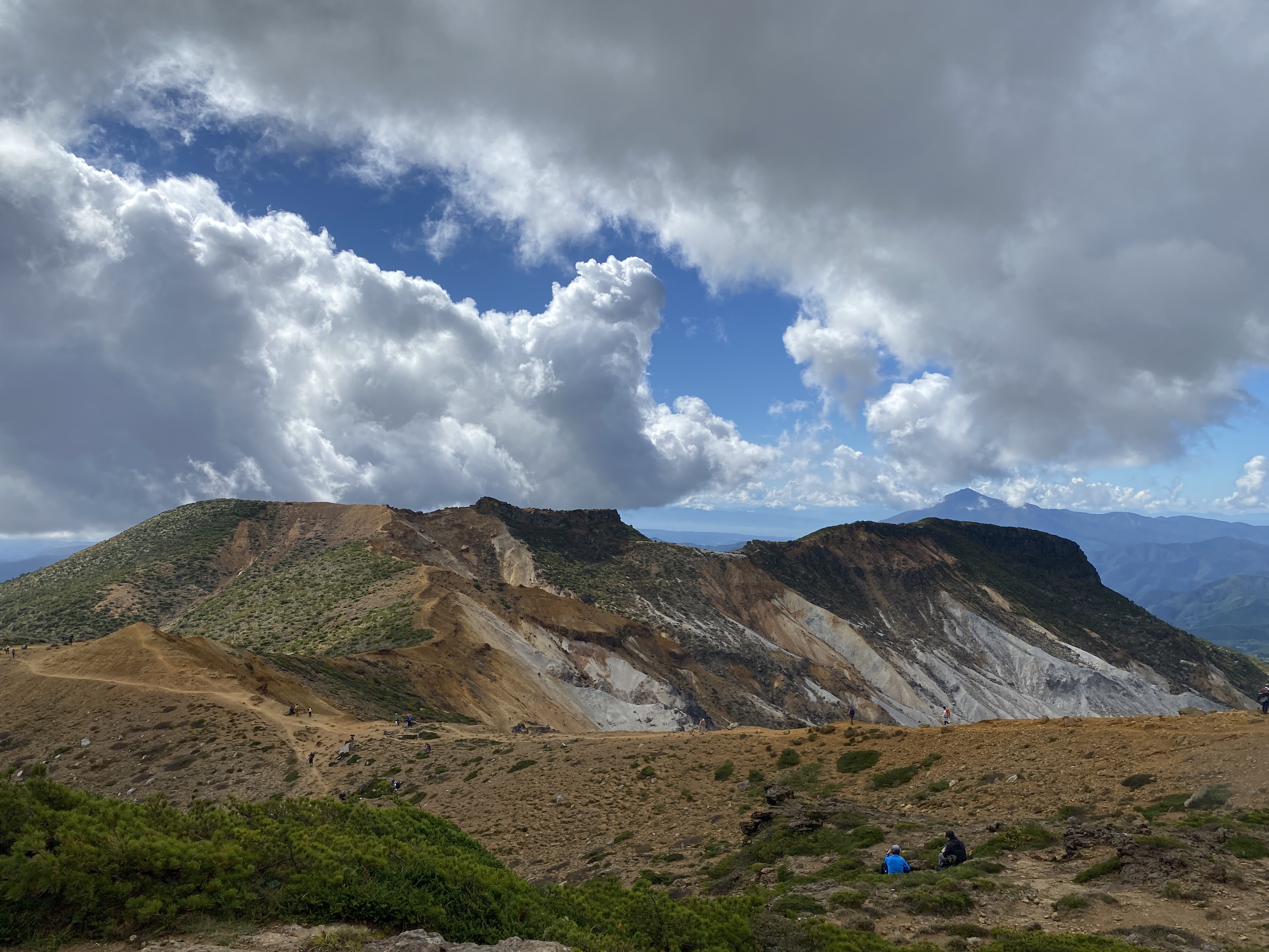
Like many volcanoes in Japan, you can smell sulfur here and there. There used to be a sulfur mine in the crater but 72 workers were killed in an eruption there in 1900. The last known eruption of Adatara was in 1996.
From the rim, you can see devices in the crater used to measure the toxicity of the gases.
Area:
Nihonmatsu City, Fukushima. About 20 minutes by car from the Nihonmatsu I.C. on the Tohoku Expressway. Fukushima is a prefecture in the Tohoku Region. Tohoku means northeast (actually, east north, but this isn't Japanese class.)
Location:
Map: Interactive topo map of Adatara
***The Caveman gave up on posting links to Yama to Kogen maps. They go out of date after a year or so and the links die. If you want a link to their latest map, comment and I'll get you a link to their latest map of the area.
Starting and stopping point:
Peaks bagged: Yakushinodake (薬師岳) ~ Adatara (安達太良山) ~ Fumamyoujin (船明神) ~ Yahazumori (矢筈森)
(First-time) peaks # 948~951
💯 Famous Mountains #41 Adatara
Getting there/getting around:
I'm not sure about public transportation. I drove. I know I saw buses there but I can't find any information online.
Helpful Info
Weather Information: Mt. Adatara (安達太良山)
Time and distance
Total Time: 3:18 Break time: :17 Distance: 8.1 km
Elevation: Lowest: 1,347 m Highest: 1,699 m Total Ascent: 508 m Total Descent: 508 m
Technical considerations/difficulty:
It's a fairly easy hike. I saw a lot of kids and grandparents. The very top of the summit has a few chains and ladders but there is a sign for the "top" just below that if anyone is not confident. If you venture to some of the adjacent peaks, (which I definitely recommend!), it's quite exposed and there is some danger of slipping.
Facilities:
There is nothing in the way of public restrooms or water from the moment you get on the gondola until you return. (There is a restaurant in the gondola station at the top. I assume that is open during ski season.)
Thoughts/observations/recommendations:
Do it. This is a fabulous mountain. It was quite crowded when I was there--but that's the price you have to pay sometimes.
This area is a bit far from us as you can see from these pictures.

This area is a 4~5 hour drive for us.

Let's get to the data, shall we?


Mrs. Caveman was with me for a bit!


The trail is really lovely. I commented on how nice the rhododendrons (シャクナゲ) are and a local hiker told me they are a special strain indigenous to the area.

The trail is nice, but was muddy in spots.


It's been too warm so far this fall for the entire mountain to burst into color but here and there there are some pretty trees.

Since it's leaf season, unfortunately there were a lot of people. It definitely was not a day for speed-hiking.


This is the last bit to the top. I heard one old lady coming up a ladder behind me saying, "kowai, kowai" 😱("I'm scared, I'm scared.")
😂


The tippety top


After coming off the top, I headed to two other peaks in the area. The first is called 船明神山. I think that is pronounced "Fumamyoujin" but I'm not sure. Like many mountain names, the combination of characters is kind of unusual and even a local Japanese guy I asked couldn't read it.
The caldera is really cool. And there were fewer people here than on Adatara. 😁

The day before, I climbed Nishi-Daiten and Nishi-Azuma (to the right).
I've climbed Bandai (on the left) twice. That is one of my favorite mountains.


The only marker on the top of Fumamyoujin.


This guy is Shinya. He's a local. We bonded early in the day over our mutual desire to move faster than the crowds. He shared with me a lot of knowledge about the local mountains. We both use the same hiking app (YAMAP) so I thought we would find each other there later. No luck, though. There are a lot of users named Shinya and too many people climbed Mt. Adatara that day to be able to sort through everybody.


I returned to our car (Suzy, the Suzuki) to find this guy standing guard.
Thanks little fella.

Well, that about does it.

Today is Monday of a 3-day weekend. Mrs. Caveman just gave me permission to go to another mountain. I had better get moving. It's already 8:30.
Check out the video of this hike.
Come again!
Caveman out.

Pat, it was finally nice to get some blue skies this past weekend. If you're chasing the correct kanji readings for mountains, Yamareco is your best friend. The reading of 船明神山 (ふなみょうじんやま) is as you said.
ReplyDeleteHi David! Where'd you go? I can't wait to see. I caught some blue skies around Yatsugatake yesterday (Monday), too. Sunday also was gorgeous but I stayed in to unpack after camping. I really wanted to get out. You're right about Yamareco for readings. I never paid for a subscription but I have take advantage of a lot of info there over the years.
DeleteYatsugatake!!
Delete