
S'up, Cavers? This is a report on a few mountains on the south side of the Yatsugatake Mountain Range, principally Mt. Io and Mt. Yoko.
. . . about Yatsugatake Mountain Range
Yatsugatake 八ヶ岳 literally means eight peaks. As I look at a banner sporting the Yatsugatake Range on my wall, I count many more than eight peaks, but I won't quibble. Yatsugatake is the name of a 30 km mountain range in Nagano Prefecture that runs north to south. The highest points are in the south, with Akadake being the very highest at 2,899 meters. The highest point in the north is Mt. Tateshina at 2,531 meters. Both of those peaks are counted among the 100 Famous Mountains from Kyuya Fukada's list.
Nearby to the west are various notable places such as Lake Suwa, Chino City, Lake Shirakaba and another of the 100 Famous Mountains, Mt. Kirigamine. Visible in the distance to the west are the Southern, Central and Northern Alps.
The eastern side of the range takes in Koumi, where Japan's highest train station is, Sakuho, Yachiho Heights, and Saku City. Visible nearby is Nobeyama, Mt. Ogura, Mt. Yokoo and several other mountains. A little farther away is Mt. Mizugaki and Mt. Kinpu, both of the 100 Famous List. Mt. Fuji is visible too.
To the north is Mt. Asama, the mountains around Karuizawa, Mt. Arafune, etc.
There are four passes to get from one side of the range to the other. I'm pretty sure they are all closed during the snow season.
The range is home to Japan's highest hotspring (outdoors, of course!), a plethora of mountain huts, lodges, campgrounds and one of the most popular spots in the country for fall foliage, Shirakoma Pond.
I am so privileged to live within the shadow of this range.
Area: Southern Yatsugatake Range
Location:
Mts. Iodake and Yokodake (Southern Yatsugatake)
Map: Interactive Topo Map (Iodake)
***If you want a link to the latest Yama to Kogen map, comment and I'll get you a link.
Starting and stopping point:
Sakuradaira Parking Lot (upper) 桜平駐車場(上)
Peaks bagged: Io Dake (硫黄岳) ~ Taizanokashira (台座ノ頭) ~ Yokodake Okunoin (横岳奥ノ院) ~ Mumeihou (無名峰) ~ Sanjahou (三叉峰) ~ Sekisonhou (石尊峰) ~ Akaiiwanokashira (赤岩ノ頭)
(First-time) peaks # 952~954
Getting there/getting around:
I drove. The 5 km up to the upper parking lot is a forest road. Quite bumpy.
There are also a lower parking lot and a middle parking lot on the same road. There is a taxi stand there.
The Ohren Lodge, which is on the trail, has this transportation information for getting there from Tokyo and for how to get a taxi, etc.
Helpful Info
Weather Information: Akadake weather
Time and distance
Total Time: 6:22 Break time: :21 Distance: 14.9 km
Elevation: Lowest: 1,875 m Highest: 2,830 m Total Ascent: 1,334 m Total Descent: 1,325
Technical considerations/difficulty:
I was able to make fairly good time on this hike because the trail is well-maintained and clear of anything like bamboo grass.
Much of this is above the treeline and exposed.
The area between Yokodake and Iodake has a lot of chains and ladders. I wore a helmet there. The rest of the hike is fairly vanilla.
Facilities:
There are several huts and campsites along the way. There is a river with plenty of water for the first and last hours of the hike.
Thoughts/observations/recommendations:
Yatsugatake is really special.
Let's get to some pictures.

The colored lines on the banner trace the hikes I've taken so far. This hike is the one in purple.

This is a long video. My feelings won't be hurt if you don't watch it all--but I enjoyed making it.🤓
The road was pretty bumpy.

After I parked and started hiking, I reflected that the trail seemed to be smoother than the road leading up to it.

Coming up to the first lodge, the Natsuzawa Kousen


The next lodge is Natsuzawa Hutte. No tent site here.

More pleasant trails on the way to the first peak, Mt. Iodake.


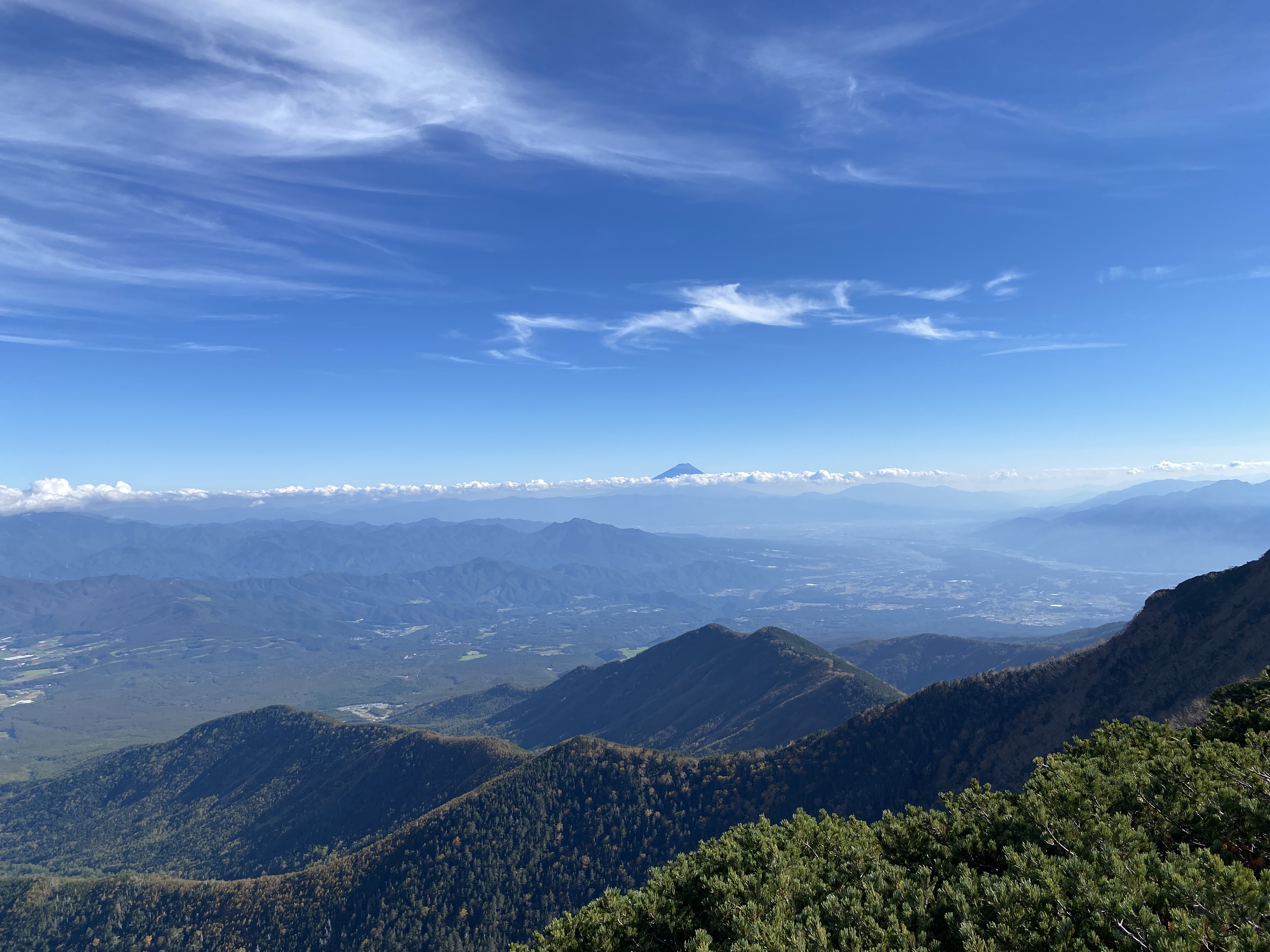
It seems like ages since I've had a good long-distance view. These some of the Northern Alps.


Looking at some of Yatsugatake to the immediate north


This is around the top of Iodake.
Io means sulfur.
It's the same word in Iwojima. Iwojima means sulfur island.

The top of Iodake

Hello, what's this I see?


balmy

Between Io and Yoko, there are quite a bit of ladders and chains.


(One of) the top(s) of Yokodake. There are 3 peaks.


I really, really love being able to pick out places I've been before.

Looking north. I live in the valley between this point and Mt. Asama. I'm hoping to hike there tomorrow night for some moon viewing.


I climbed Komagatake and Senjogatake last month (or this month, they all bleed together.) I have a better view of them on this clear day than I did when I was actually there! Kita-dake is Japan's second-highest mountain. It is a real treat.


After those last pics, it was time to turn around. My return would take me back to Iodake before turning onto a new trail for a while.


Well, that's it kiddos. That was fun. I think I should post some video of this hike. It was so picturesque that day.
Don't forget to subscribe and tell your friends about this blog.
If you want to see more of Yatsugatake, check out Akadake or you might check out this hike near Nobeyama, which is visible in the foothills beside Yatsugatake. Mt. Meshimori, etc.
Caveman out.

No comments:
Post a Comment
Have a comment? Please, keep it clean.