

Greetings cave critters and spelunkers of all ages and sizes.
Let me tell you about a few mountains in the Northern Yatsugatake area, "Kitayatsu" as its known by all the cool kids around here.
This hike starts at the Mugikusa Pass and goes over several peaks on the way up to Mt. Kita Yokodake.
Speaking of "Kita Yokodake" gives me the chance to give you a glimpse into the Caveman's world. The Caveman tries to be, if nothing else, informative about hiking in Japan and always strives to express the essential zenness of hiking in Japan. I like to give you a taste of the inner essence of things not easily accessible to the occidental mind.
Japanese is an intriguing language and puzzling through what words mean is sometimes very difficult. Mountain names are particularly bizarre. Even Japanese people often get confused about mountain names.
There are 3 parts to the name of the mountain in question, "Kita", "Yoko" and "Dake". "Kita" means north. That's easy. "Dake", is a word that means high mountain or peak. That's obvious. It's the "Yoko" part that is in question. The word Yoko has often been translated as the name of that screeching banshi of a woman who broke up the Beatles. (Oops, did the voice in my head almost escape again?) Yoko can mean horizontal or side by side. Let's think about that. "North" + "Horizontal" +"Peak". Can a peak be horizontal? I don't think so. Can a peak be "side by side" (with itself?) Maybe. Perhaps we're dealing with some kind of koan.
What is the sound, Grasshopper, of one peak beside itself?
The Caveman isn't yet satisfied with these translations. Let's look at other possibilities for "yoko". It can mean "width", "woof" (not "ruff" 🐕 ?) or "perverse." Hmmmm. "North" + "Perverse" + "Peak".
Let's just give up on trying to comprehend this name.
Yesterday was a great day. It was a very out of the ordinary day for the Caveman. He had a hiking companion. His nephew John was visiting from the States and came for the trip. John is a member of a very elite few--those that the Caveman will willingly hike with.
Actually, John is someone I like hiking with. That is a very small number of people indeed.
Stick around, maybe you will catch a glimpse of his handsome mug in this blogpost.
Here are the details and stats:
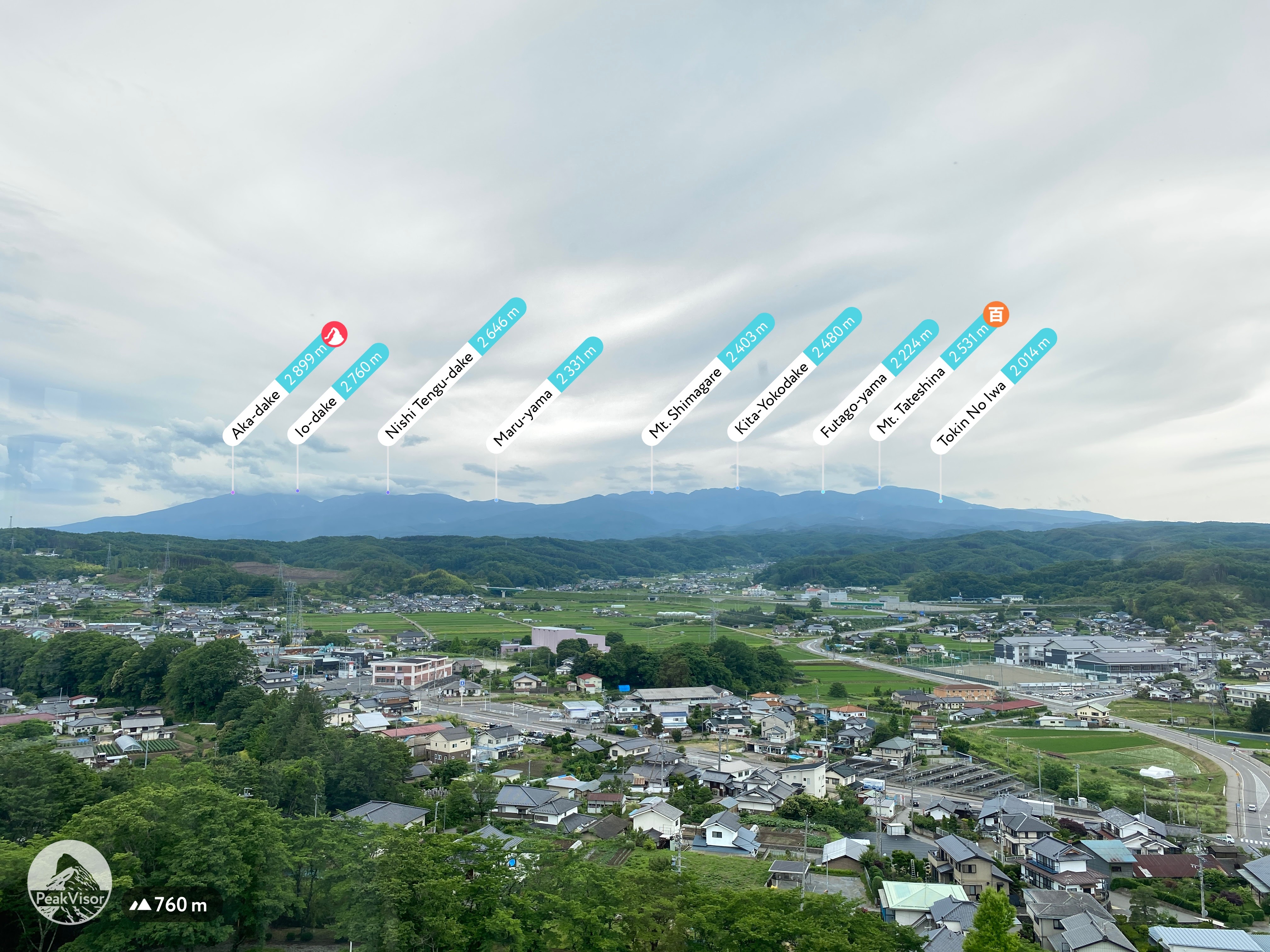
Location: Northern Yatsugatake Range in Nagano
Starting and stopping point: Mugikusa Pass
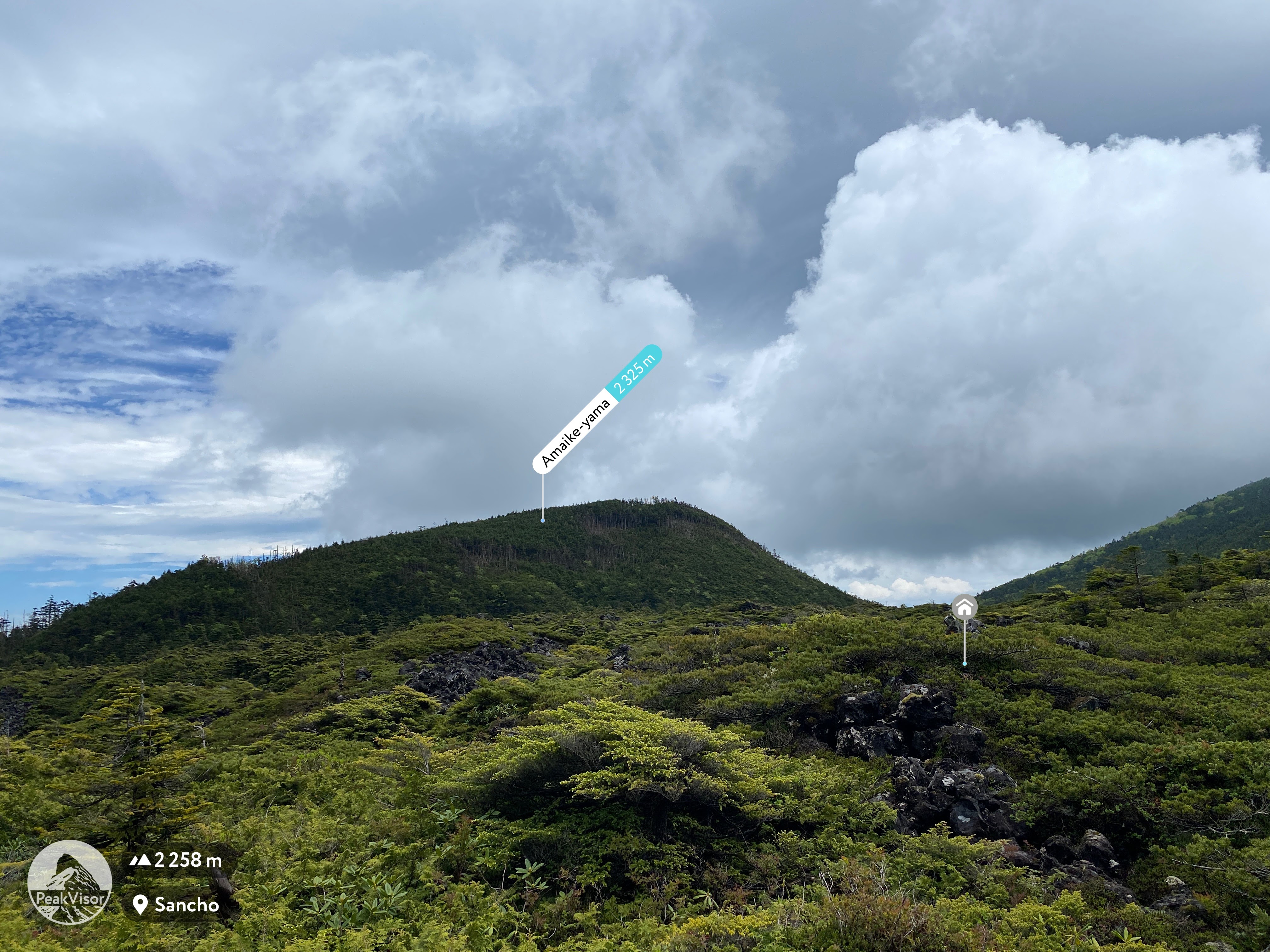
Peaks bagged: Nakaoba ~ Chausu ~ Shimakare ~ Amaike ~ Mitsudake ~ South Kitayokodake ~ North Kitayokodake
(First-time) peaks #895~898
Getting there/getting around: I drove. I probably wasn't supposed to but I parked at the entrance to the Mugikusa Hut. My map said that parking at the hut was free but the hut was closed since it was a Monday. I took the risk that I wouldn't earn anyone's ire by parking just outside the gate at their entrance. It seemed ok. There is a pay parking lot at the Shirakomaike Pond 1.2 km down the road. Parking on the side of the road in the area is strictly prohibited. There are signs threatening that vehicles will be towed.
The Chikuma Bus company has a bus stop at the Mugikusa Hut. You can get there from Yachiho Station on the Koumi Line in just under an hour. The Alpico Bus Company also has bus going there from Chino. That takes a little over one hour. Sorry. The timetable is in Japanese.
Map: Yama to Toge Map 八ヶ岳 蓼科・美ヶ原・霧ヶ峰
Weather Information: Kitadake Weather
Total Time: 5:59 Break time: :38 Distance: 12km
Elevation: Lowest: 2,081m Highest: 2,274m Total Ascent: 793m Total Descent: 793m
Technical considerations/difficulty: It being rainy season, we got wet. As soon as you enter the trailhead at Mugikusa Pass, the trail goes over a marsh. Much of the trail is covered with water at this time of year. John was in sneakers and spent much of the day trying to leap over puddles. In many places, the trail was basically a stream of running water.
Our trail out to Kitayokodake was mostly on top of the ridgeline of the Yatsugatake Range. Being the ridge, it was a bit gnarly. Lots of boulder fields. Not an easy place make time. Between the boulders, there are places with deep crevasses. I would hate to drop a smartphone, (or person), into one of them. Let me rephrase that. I'd hate to fall into one myself. There maybe a person or two I'd like to drop into one of them.😉
There are some places with chains or ropes that necessitate some upper body strength.
On our return, we paralleled our outgoing path on the west side of the ridge. It was a much gentler return and we moved faster. Actually, we encountered a lot of daytrippers who had come up on the ropeway for a short walk around the scenic points. They were not dressed for hiking and didn't need to be. From the ropeway, it's a very easy walk up to a peak or two. Many people use the ropeway in the winter as a way to experience winter hiking without too much effort. (That is so cheating to the caveman.)
Facilities: There is lodging with toilets and various food items, etc for sale at Mugikusa Pass (when the hut is open). Shirakoma Ike Parking lot down the road has a souvenir shop. The lodge near Kitayokodake has a pay toilet. That was also closed when we passed yesterday. There are no waterholes marked on this trail but we found more than enough running water. There is also a hut near Shimakure Yama, but we didn't pass by there.
Thoughts/observations/recommendations:


No comments:
Post a Comment
Have a comment? Please, keep it clean.