The Caveman's Revenge. Going back to Kitayokodake for the view.


Kikkooike

Hey there, spelunkers.  The Caveman is here to regale you again.

Kitayatsu hike(s)

Location:  Northern Yatsugatake Area "Kitayatsu"

Starting and stopping point:  **(For the main hike) Ogawahara Pass (大河原峠)

Peaks bagged: Futaga ~ Ootake ~ Kitayokodake     *Side hike: Ryugamine

(First-time) peaks #899  Oops.  #900.

Getting there/getting around:  I drove.

Map:  ***The Caveman is giving up on posting links to maps.  They go out of date and the links die.  If you want a map, comment and I'll get you a current link.

Weather Information: Kitayokodake Weather 

Stats (for the main hike only)

Total Time: 4:25  Break time: :31  Distance:  8.9 km

Elevation  

Lowest: 1,972 m Highest: 2,480 m Total Ascent: 788 m  Total Descent: 788 m

Technical considerations/difficulty:  

From Futagoike up to Otake and Kitayokodake is a bit strenuous.  There are a lot of boulders you need to scramble over.  (I actually had a plan to hike from Futagoike up to Kitayokodake in May but had to turn back at Otake because those boulders--especially with snow around them--took more time that I'd anticipated.)  Descending from Kitayokodake to Kikkoike is a bit steep, too.  From there back to Ogawahara Pass is a walk in the park.

Facilities:  

There are restrooms at Ogawahara Pass, Futago Ike Hut and Kitayokodake Hut.  There is also a place to rest at the Ogawahara Pass parking lot.  The Futago Ike Hut and campground (Tateshina Hut info, too) is seasonal.   There is a waterhole on the map at Futago Ike Hut but I don't recall ever actually seeing it. The Kitayokodake Hut's info is at that link.  They require reservations by phone and aren't open unless there is someone with a reservation.  Click on this link for the Kita Yatsugatake Ropeway.  

Thoughts/observations/recommendations:

I love these mountains so much.  Since the Caveman lives in the valley below, the views from Yatsugatake and all the surrounding mountain ranges enable me to look down on where I live and across to other mountains I frequent.

If you want to get to experience the views of the area without the stress, you could take a ropeway that goes near the top of Kitayokodake.  The other day, I mentioned to a middle-aged woman that I'd climbed Kitayokodake and she said, "Oh, I know that one.  That's an easy one."  My reaction was, "You must be putting me on, lady."  Later I realized that she must have used the ropeway.  Either that or I'm a pathetic example of a caveman.

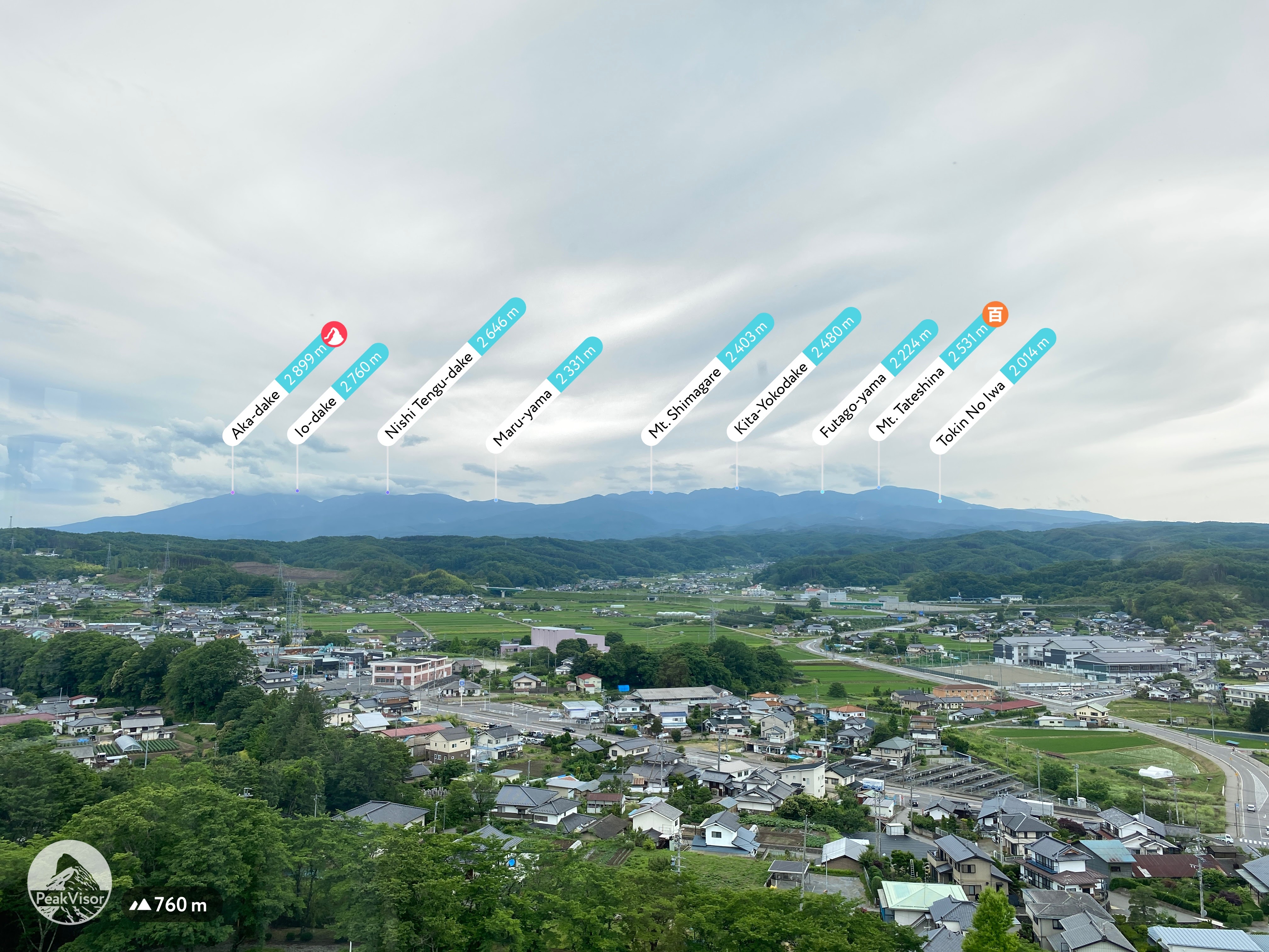
If you want to experience a nice view with even less exertion, you could just take a drive up the Tateshina Skyline to the Ogawahara Pass and take a peek at Mt. Asama, etc. from there.


Today's listening:  

War, peace & cherry trees: finding hope after WW2  This was surprisingly good.  I learned some new things about Fr. Maximillian Kolbe I didn't know and also about two other great Japanese men.  This is an interview with Naoko Abe, author of The Martyr and the Red Kimono: A Fearless Priest's Sacrifice and a New Generation of Hope in Japan.  

Had enough preliminaries yet?  You haven't left yet?

Here're the visuals.  A few days ago, I had a plan to connect the dots with trails I've trodden before.  I had been to Otake before from the north side and intended to go there again from the south, passing Kitayokodake on the way.  Alas, I only made it as far as Kitayokodake that day--and it was raining so we didn't see anything.  That is the yellow portion on the screenshot below.  On this trip, I had to cover a lot of ground I've walked on before but managed to tie up the loose ends between Otake and Kitayokodake I'd not been able to before.

(Were you paying attention to that?  There will be a quiz.  You need to remember the Japanese mountain names, their correct spellings, their English translations, the dates of travel and to each mountain and what the Caveman had for lunch on each day.  You will need a score of at least 80% in order to pass.)

google earth of hikes


By the way, this banner is a profile of the Yatsugatake Range.  It will probably take me 3 or 4 more hikes to finish it end to end.


Check out Caveman conquering Kitayatsu


Start out at the Ogawahara Pass.  

Ogawahara

Heading toward Futago Yama -"Twin Mountain"

up toward Futago Yama

That post is the top of Mt. Futago.

Twin Mountains peak

Tateshina from Futago


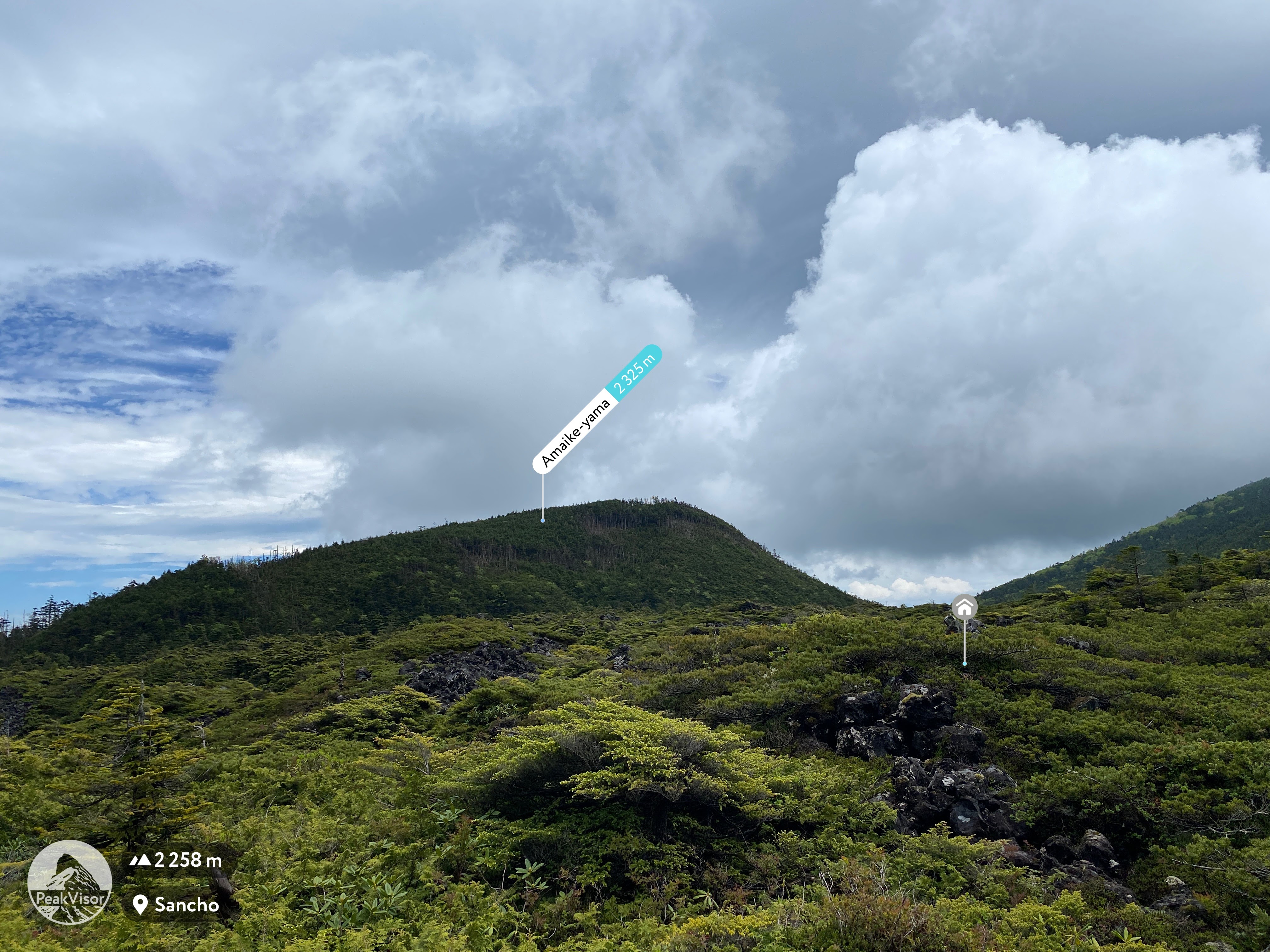
Looking toward the next peaks, Ootake and Kitayokodake.  


Still on Futago Yama


Looking up at Ootake from behind the hut at Futago Ike--"Twin Ponds"--after descending from Futago Yama.


The next two pics are of the twin ponds
Futago Ike

双子池


Mrs. Caveman would call this magic.

Magic

Ootake

The southern end of the Yatsugatake Range

Minamiyatsu


This is near the top of Kitayokodake.

The water below is the 七ツ池 (Nanatsu Ike--"Seven Ponds").  The structure to the right is the Kitayokohutte


This is the South Peak on 6/24.
Kitayokominami

. . .  and two days later.


This is the north peak
Kitayokodakekita

. . . and two days later.
(Sorry I spoiled the picture with my ugly mug.)

Kitayokodakekita


Ondake is one of the 100 Famous Mountains.


Some of the Northern Alps

Northern Alps


After descending from Kitayokodake, arriving at the Kikkoike.

Kikkoike

Upon reaching the pond, the terrain and foliage changes considerably until the end of the loop back to the starting point at Ogawahara Pass.  The last bit is through the Tenshojihara (Tenshoji Field) of bamboo grass.


Looking back at where I'd come from.


looking back

After this hike, I made two other stops a bit down the road.  The first was 兜巾の岩 (Tokin Boulder).  It's just off the side of the road and only takes 3 minutes to climb but there were cool views and it was actually a bit scary.


Tokin no iwa

The second stop was to bag a peak.  I certainly did some hiking earlier in the day but hadn't bagged any new peaks.  Just a bit further down the road my map informed me there is a peak called Ryugamine--"Dragon Peak".  I dropped by there.  I parked at the 7th Station trailhead of Mt. Tateshina and hiked a few kilometers to the peak.  On the way, I passed through something of a bird sanctuary and dropped by the Ryusen Falls.

(This place, the 御泉水自然園 Gosensuishizenen Park, is right next to the mountain/bird sanctuary.  Parking isn't free, though.  Where I parked was free.  Ha!)


It was a looooong walk down.

Ryusen Falls


Ryusen Falls

After the falls, I headed toward the "mountain."

The peak was really quite boring.  There was nothing to see at all.


If nothing else, it added one more to the list.  This is #899.  Where should I go for the 900th, I wonder?
I feel like I robbed myself.  I just have been informed by no less an authority than the climbing app I have that this was #900.  It was one of the least memorable mountains I have ever been on.  Ugh!😜

Leave a comment if you like.  If you want to see something else from this area, check out my first venture up here.


Caveman out


.


Caveman conquers Kitayokodake. Mugikusa Pass to Mt. Kitayokodake.

stream


Greetings cave critters and spelunkers of all ages and sizes.  

Let me tell you about a few mountains in the Northern Yatsugatake area, "Kitayatsu" as its known by all the cool kids around here.

This hike starts at the Mugikusa Pass and goes over several peaks on the way up to Mt. Kita Yokodake.  

Speaking of "Kita Yokodake" gives me the chance to give you a glimpse into the Caveman's world.  The Caveman tries to be, if nothing else, informative about hiking in Japan and always strives to express the essential zenness of hiking in Japan.  I like to give you a taste of the inner essence of things not easily accessible to the occidental mind.  

Japanese is an intriguing language and puzzling through what words mean is sometimes very difficult.  Mountain names are particularly bizarre.  Even Japanese people often get confused about mountain names.  

There are 3 parts to the name of the mountain in question, "Kita", "Yoko" and "Dake".  "Kita" means north.  That's easy.  "Dake", is a word that means high mountain or peak.  That's obvious.  It's the "Yoko" part that is in question.  The word Yoko has often been translated as the name of that screeching banshi of a woman who broke up the Beatles.  (Oops, did the voice in my head almost escape again?)  Yoko can mean horizontal or side by side.   Let's think about that.  "North" + "Horizontal" +"Peak".  Can a peak be horizontal?  I don't think so.  Can a peak be "side by side" (with itself?)  Maybe.  Perhaps we're dealing with some kind of koan.  

What is the sound, Grasshopper, of one peak beside itself?  

The Caveman isn't yet satisfied with these translations.  Let's look at other possibilities for "yoko".  It can mean "width", "woof" (not "ruff" 🐕 ?) or "perverse."  Hmmmm.  "North" + "Perverse" + "Peak".

Let's just give up on trying to comprehend this name.

Yesterday was a great day.  It was a very out of the ordinary day for the Caveman.  He had a hiking companion.  His nephew John was visiting from the States and came for the trip.  John is a member of a very elite few--those that the Caveman will willingly hike with.  

Actually, John is someone I like hiking with.  That is a very small number of people indeed.

Stick around, maybe you will catch a glimpse of his handsome mug in this blogpost.


Here are the details and stats:

Location:  Northern Yatsugatake Range in Nagano

Starting and stopping point:  Mugikusa Pass

Peaks bagged: Nakaoba ~ Chausu ~ Shimakare ~ Amaike ~ Mitsudake ~ South Kitayokodake ~ North Kitayokodake

(First-time) peaks #895~898

Getting there/getting around:  I drove.  I probably wasn't supposed to but I parked at the entrance to the Mugikusa Hut.  My map said that parking at the hut was free but the hut was closed since it was a Monday.  I took the risk that I wouldn't earn anyone's ire by parking just outside the gate at their entrance.  It seemed ok.  There is a pay parking lot at the Shirakomaike Pond 1.2 km down the road.  Parking on the side of the road in the area is strictly prohibited.  There are signs threatening that vehicles will be towed.

The Chikuma Bus company has a bus stop at the Mugikusa Hut.   You can get there from Yachiho Station on the Koumi Line in just under an hour.  The Alpico Bus Company also has bus going there from Chino.  That takes a little over one hour.  Sorry. The timetable is in Japanese. 

Map:  Yama to Toge Map 八ヶ岳 蓼科・美ヶ原・霧ヶ峰

Weather Information: Kitadake Weather

Total Time: 5:59  Break time: :38  Distance:  12km

Elevation:  Lowest:  2,081m Highest: 2,274m Total Ascent: 793m  Total Descent: 793m

Technical considerations/difficulty:  It being rainy season, we got wet.  As soon as you enter the trailhead at Mugikusa Pass, the trail goes over a marsh.  Much of the trail is covered with water at this time of year.  John was in sneakers and spent much of the day trying to leap over puddles.  In many places, the trail was basically a stream of running water.

Our trail out to Kitayokodake was mostly on top of the ridgeline of the Yatsugatake Range.  Being the ridge, it was a bit gnarly.  Lots of boulder fields.  Not an easy place make time.  Between the boulders, there are places with deep crevasses.  I would hate to drop a smartphone, (or person), into one of them.  Let me rephrase that.  I'd hate to fall into one myself.  There maybe a person or two I'd like to drop into one of them.😉

There are some places with chains or ropes that necessitate some upper body strength.

On our return, we paralleled our outgoing path on the west side of the ridge.  It was a much gentler return and we moved faster.  Actually, we encountered a lot of daytrippers who had come up on the ropeway for a short walk around the scenic points.  They were not dressed for hiking and didn't need to be.  From the ropeway, it's a very easy walk up to a peak or two.   Many people use the ropeway in the winter as a way to experience winter hiking without too much effort.  (That is so cheating to the caveman.)

Facilities:  There is lodging with toilets and various food items, etc for sale at Mugikusa Pass (when the hut is open).  Shirakoma Ike Parking lot down the road has a souvenir shop.  The lodge near Kitayokodake has a pay toilet.  That was also closed when we passed yesterday.  There are no waterholes marked on this trail but we found more than enough running water.  There is also a hut near Shimakure Yama, but we didn't pass by there.

Thoughts/observations/recommendations:  


googleearth of Kitayatsu


Let's look at some pictures.

This is before we started.  It was drizzling most of the day but we were lucky enough to get a bit of clear sky just as we hit the Yama no Eki's scenic viewpoint on Route 299 on the way.  

Koumi Furusato

This is where we started out.

Mugikusa Pass

The marsh at the trailhead


Chausu

wind

windy

chains


Chain

Trail

Kita Yokodake Hut

Kitayoko

Kitayokon


Nanatsuike


boardwalk


Whatever hope we had of staying dry had to be abandoned here.  This huge field of sasa seemed to be completely submerged in a few inches of water.

sasa


stream


Well, that is it for today.

Check these posts out if you are interested in this area

I'll be back soon.  Make sure to subscribe to stay up to day.  Tell others about this blog.  Google seems determined to hide me from their search engine.

Caveman out.

Epilogue

After coming off the mountain, we dropped by Cosmos Tower in Saku.  It's a rocket with an observation deck!  It's a great landmark from the surrounding mountains.  The first picture is of that Cosmos Tower.  The second shows where we were as taken from there.

Cosmos Tower