
Fowl Play!
 I'm the caveman. My mancave is the mountains. Google dislikes me so nobody can find my blog. I keep doing it though, because I want to remember all the great places I've been able to see and I have a bad memory.
Tales From The Mancave , the trailer
I'm the caveman. My mancave is the mountains. Google dislikes me so nobody can find my blog. I keep doing it though, because I want to remember all the great places I've been able to see and I have a bad memory.
Short hike in Tomioka City

Starting and stopping point: Kannari Trailhead Parking Lot (神成登山口駐車場) by the Shinbori Shrine (新堀神社) in Tomioka, Gunma.
Peaks bagged: Mt. Azuma 吾妻山 ~ Mt. Ryuou 竜王山
(First-time) peaks # 876 and 877
Getting there/getting around: I drove. The nearest train station is Nanjaieki (南蛇井駅) (19 min. walk). Alternatively, you could get off at Kanohara (神農原駅) and start the hike from the other end, by the Miyazaki Park (宮崎公園).
Map: 西上州 21 妙義山・荒船山
Weather Information: Look for a weather report for Tomioka City. These hills aren't high enough to rate a mountain forecast.
Total Time: 2:22 Break time: :19 Distance: 5.9
Elevation: Lowest: 204 m Highest: 320 m Total Ascent: 477 m Total Descent: 477 m
Technical considerations/difficulty: None
Facilities: Benches here and there at nice viewpoints. One spot has picture books with pics of the area in each season. There is also a display case of some bits of nature--snail shells, a stuffed martin. That was neat.
Thoughts/observations/recommendations: This was just a quick walk. I wanted to get in a little more time in the woods before I go back to work in a few days. It was quite a difference from my slog through the snow the day before. This place is very low in elevation and it was really warm. I saw butterflies and bees and all the flowers seemed to have bloomed overnight. I was hiking in a t-shirt.
I'm not going to put up many pictures, dear cavedweller. This was pretty minor as treks go. I am making this post merely for my own memory. ☺


That's all for today.
Caveman out.
I'm the caveman. My mancave is the mountains. Google dislikes me so nobody can find my blog. I keep doing it though, because I want to remember all the great places I've been able to see and I have a bad memory.
The tale of the crooked nose and the frigid wife. Mt. Hanamagari and Mt. Hizuma.
Location: Mt. Hanamagari on the line between Gunma and Nagano
Starting and stopping point: Scenic Overlook at Nidoage Pass
Peaks bagged: Mt. Hizuma (氷妻山), Mt. Hanamagari (鼻曲山)
(First-time) peaks # 874 and 875
Getting there/getting around: Car. There is a parking lot at the Nidoage Pass (二度上峠) that can accommodate 4 or 5 cars in the non-snow seasons. I had to park at another lot about 500 meters down the street as that parking lot was snowed in.
Map: Yama to Kogen Chizu 19 浅間山軽井沢・長野原の山々ASAMA-YAMA KARUIZAWA-NAGANOHARA-MOUNTAINS
Weather Information: Mt. Hanamagari Weather
Total Time: 3:47 Break time: :14 Distance: 7.2 km
Elevation: Lowest: 1,372 m Highest: 1,655 m Total Ascent: 625 m Total Descent: 625 m
Technical considerations/difficulty: The challenge today was snow. Although there has been a lot of melting, much of this trail is still covered with about a foot (30cm) or more. Some areas are along or near ridges with steep dropoffs. I took great care not to slide off the mountain or to start an avalanche. The pink ribbons marking the trail were sufficient.
Facilities: Nothing.
Thoughts/observations/recommendations: I've wanted to do this mountain since I climbed Asama Kakushi back in December. I was really tempted to do it that day but decided to wait.
Today's listening: For You The War Is Over

Greetings Cavedwellers.
This is my report on the crooked nose and the frigid wife.
I imagine that introduction inspires images of old crones and unhappy married couples. Nothing could be farther from the truth. It just happens that the two mountains I feature today have funny names.
One of the mountains is Mt. Hanamagari (鼻曲山). "Hana" is 'nose' and "magari" could be either 'song' or 'bend.' I think bend is more likely. So, crooked nose is a pretty good translation. The other mountain is Hizuma (氷妻山). "Hi" means 'ice' ❄️ and "zuma" means 'wife.' 🥶 Shudder.
Not much to say about it. I just wanted to get out before the snow melts.
Here are some pics.
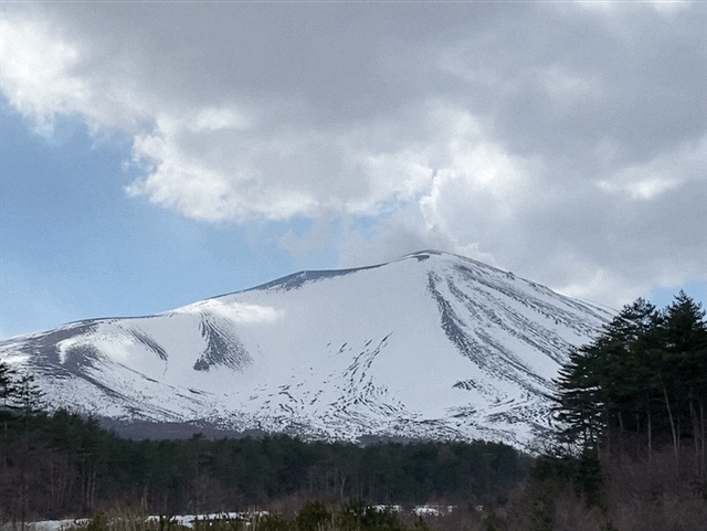
This is Asama and the adjacent plateaus from the road.

. . . and Asama again from my starting point, Nidoage Pass.


This was interesting. The road crews are picking up the signs that say to be careful of the freezing roads.
Maybe it's time to switch out the ol' snow tires.


This is Mt. Frigid Wife.


Mt. Crooked Nose

Mt. Crooked Nose is the bump on the left.
These hills have a lot of bumpy areas and large boulders that make them cool-looking.

Going down, as is often the case, was harder than going up. It was very easy to start to slip, potentially causing an avalanche.


That's all for today.
Caveman out.
I'm the caveman. My mancave is the mountains. Google dislikes me so nobody can find my blog. I keep doing it though, because I want to remember all the great places I've been able to see and I have a bad memory.
Big Buddha and Deer in Nara
This was fun
Caveman out
I'm the caveman. My mancave is the mountains. Google dislikes me so nobody can find my blog. I keep doing it though, because I want to remember all the great places I've been able to see and I have a bad memory.
Mt. Haruna of 200 Famous Mountains Fame
Lake Haruna

Hello, cavedwellers.
Today's trek was around Lake Haruna in Takasaki, Gunma.
Location: Lake Haruna, Takasaki, Gunma
Starting and stopping point: Visitor's Center Parking Lot (Public Restroom)
Peaks bagged: 氷室山 ~ 天目山 ~ 榛名富士 ~ 烏帽子ヶ岳 ~ 鬢櫛山 ~ 榛名山(掃部ヶ岳)
(First-time) peaks # 868 ~ 873
Getting there/getting around: I drove. There are several free parking areas. I don't know how empty they are during tourist season, though.
Map: 山と高原地図 赤城・皇海・榛名 袈裟丸山・足尾山地 2024
Weather Information: Haruna Weather in Japanese
Total Time: 7:48 Break time: 1:24 Distance: 12.6 km
Elevation: Lowest: 1,085 Highest: 1,449 Total Ascent: 1,367 Total Descent: 1,367
Technical considerations/difficulty: Each of these mountains, by itself, is not particularly challenging. Any of these peaks could be done in just a few hours. Circumambulating (I love that word.) the lake, as I did, makes for several ascents and descents. There are some areas where the snow is deep and some places with ropes where you need some upper-body strength.
The snow conditions varied widely on this trek. In spots, it is waist-deep. On the south side of Haruna Fuji, there is no snow at all. I needed snowshoes only for about 30 minutes. Most of the rest of the day I needed crampons. Going down was very slippery and icy in places.
Facilities: There is nothing on the trails or mountaintops, but the lake is nearby and has many public facilities and tourist attractions. Not much is open in the off-season, but the Yusuge Onsen is open and only costs ¥520.
Thoughts/observations/recommendations: If you want to catch the view but are lazy, you could take the gondola to the Haruna Fuji Ropeway. ¥950 roundtrip for adults.
I don't feel particularly witty today, so I'll just jump into the pictures.

On go the snowshoes.
Thankfully, the temp. stayed at or below freezing all day. I didn't need to deal with much melting snow or mud.


After going up to the first two peaks, I came back down to the water level--before going up again. I repeated this a few times this day. 😜

Looking up toward Haruna Fuji


The view from Suzuri Iwa ("Inkstone Boulder") is the best one of the lake.
Kamongatake is the highest peak of the Haruna Mountains. That was my last peak of the day.

The hike up to Haruna Fuji is on the south face of the mountain so all the snow was melted. That was the only snowless trail of the day. In contrast, the other side of the mountain was very deep.

Asama is 32 km away.

Mountain Graffiti!
"Sagamihara F.D."
"Isesaki F.D."

Ropeway prices.

Just beside the ropeway, there is a viewpoint.

It's 124 km to Mt. Fuji.


On a clear day, you can pick out Mt. Tsukuba (113 km) and Tokyo's Skytree (119 km). It was too hazy to see Tsukuba. I was able to find Skytree with the naked eye but my iPhone couldn't pick it up.


From the Ropeway, it's maybe a ten-minute walk up to the top.

"This way to the top and to the Haruna Fuji Shrine"


The shrine

Time to put the crampons on. This side of Haruna Fuji is very snowy.

Time to go down.
Again.

Lots of critters out here.
A few times I could actually smell the deer.


After slipping and sliding down the 300 meters to the lakeside, I looked up at my next destination--Mt. Eboshi--in disbelief.
"Did I really put that in my plan?"

Eboshi is the word for traditional pointed hats. There are many mountains named eboshi here.
This dude Lord Ashikaga really rocked one of those hats back in1868!

The trailhead to Eboshi.

From the top


Dining al fresco.

After Eboshi, the next stops were Mt. Bingushi and Suzuri Iwa.


From Suzuri Iwa ("Inkstone Boulder")

On the way up to Suzuri Iwa, I passed a young couple wearing jeans, sneakers and sweatshirts. It was a nice day, so they just hopped out of their car on a whim to head up to the overlook. They did not really think it through, though. They got up to the top and then considered that going down would be harder than coming up. The trail isn't long, but it is very steep and icy in many places.
Oh, to be young and in love . . . stupid. 😆
I gave them my hiking poles and wished them luck.
The biggest mountain in the next picture is Mt. Akagi. I climbed that last year.
https://mymancaveisthemountains.blogspot.com/2023/04/mt-akagi-red-castle-one-of-japans-100.html

This is what greeted me as I came off the mountain.

Back to the lake level


I dropped by the Haruna Lake Yusuge Moto Onsen and was greeted by these guys.
The fat one is definitely the alpha cat.

Men to the left. Women to the right.

I snuck a picture of the bath. I won't put it up here, though.
When I got home and looked at the picture, I realized there was a person in it! When I took the picture, he was not visible to me and I doubt he could see me either, because he was outside and the window was all steamed up. Imagine my surprise when I got home and looked at my pictures to realize the iPhone had picked up his image.
Thank God it was too blurry to see anything. I'd have to wash my eyes with bleach or something.

That's all for today.
Caveman, out.
I'm the caveman. My mancave is the mountains. Google dislikes me so nobody can find my blog. I keep doing it though, because I want to remember all the great places I've been able to see and I have a bad memory.
Subscribe to:
Posts (Atom)