Welcome ladies and gentlemen, boys and girls, cave visitors of all ages.
How'd you like my clickbait title? It's hard to become an influencer. In my last few posts, I mentioned skinnydipping and you wouldn't believe how many views I got. I'm not sure how I feel about the type of new readers I'm getting, though.
Unlike many internet entities; I'm not lying with my titles. Maybe gilding the lily a bit, but I'm not lying. Keep reading and you'll see what I mean.
Honest. You can trust me. I'm not like the others.
Anyway . . .
I went for a bit of a hike on the Yatsugatake Range yesterday. It wasn't a picture-perfect day, but it was still a great experience.
Getting there/getting around: I drove. There are buses to the trailhead I used. They run between the Nitago Onsen and Koumi Station 4 times a day starting in April 22. I guess they run until the snow makes the road impassible.
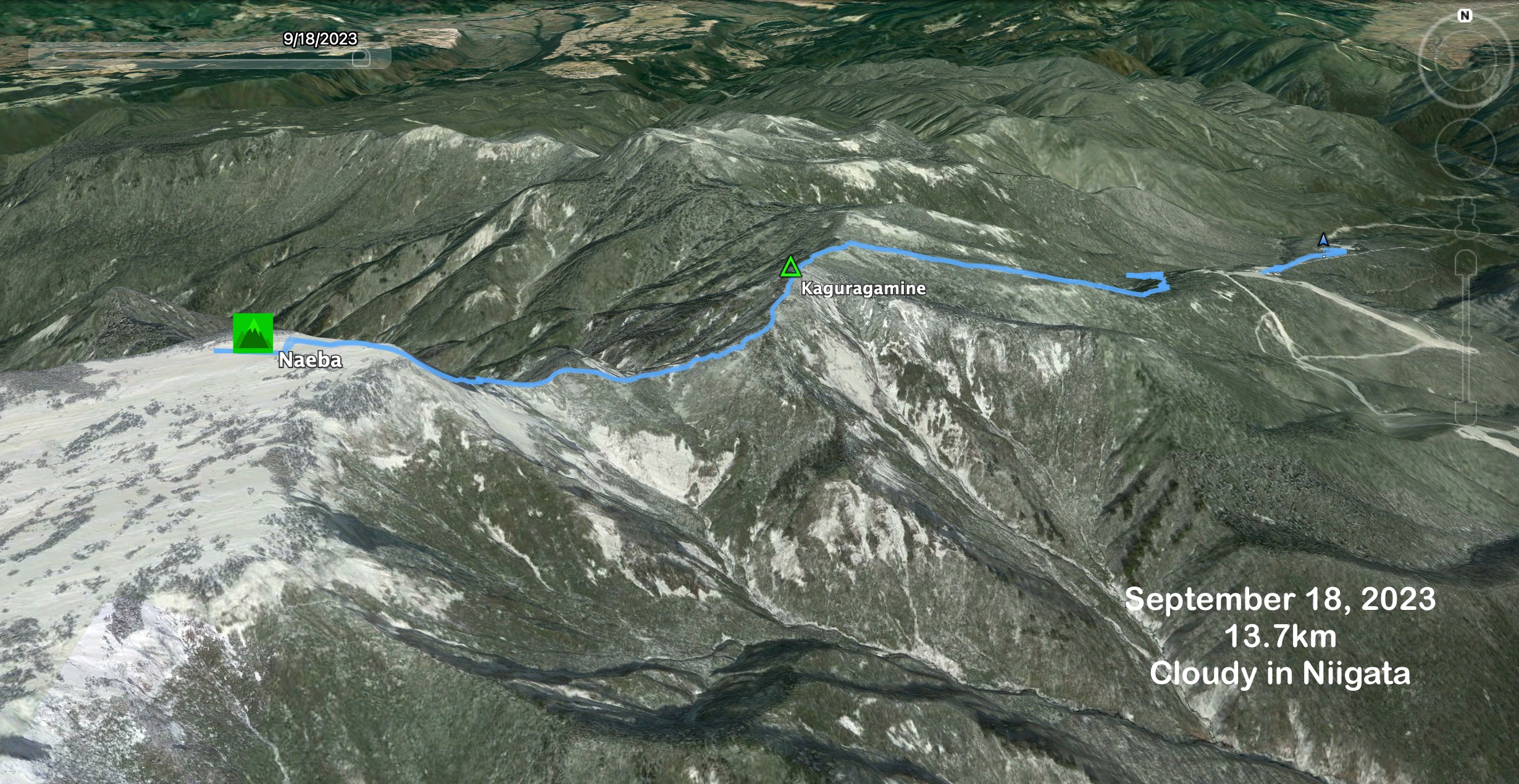
Total Time: 7:08 Break time: :36 Distance: 16.5 km (just over 10 miles)
Elevation:Lowest: 1,571 m Highest: 26,46 m Total Ascent: 1,386 m Total Descent: 1,386 m
Technical considerations/difficulty: Much of this is above the treeline. There are not a lot of spots with chains or ropes but a lot of this hike is steep and there are a lot of boulders to negotiate. I think the only places where getting lost would be a possibility would be at trail intersections. Most of them are well-marked, though. If you pay attention, you should be fine.
Facilities: There are lots of onsens, huts and waterholes. There are several campgrounds.
Thoughts/observations/recommendations: This is, I'm sure, a great collection of mountains, but I really don't know just what they look like. It was not clear enough long enough over a wide enough area for me to have gotten a good look! The one peek I got of the peak of Tengudake from below was really cool. This is another on a long list of mountains I have to go back to.
I was surprised at the number of onsens and campgrounds in the area. I also was surprised by the number of people I saw. It didn't ever seem crowded, but there were a surprising number of hikers up there.
"The only possible excuse for this book is that it is an answer to a challenge. Even a bad shot is dignified when he accepts a duel." Orthodoxy
I have listened to or read Orthodoxy, and a few other Chesterton classics, several times. I find more and more gems each time. He's not immediately accessible. I find that the first 90% of a chapter is usually bewildering and takes a lot of concentration. The last 10% or so when he pulls everything together makes the hard work worthwhile! And, along the way, some of the quotes are just so clever and, well, quotable.
OK.....let's look at some pictures
The Shirabiso Hut next to Midori Ike. There are camping sites here as well as some food, etc.
Midori Ike (Green Pond)
Looking up toward my invisible destination, Mt. Tengu.
Looking up from Midori Ike in another direction toward Mt. Inago.
Back on the trail
Mt. Tengu's eastern peak
Looking back at the eastern peak from the western peak.
People were standing and waiting with their cameras for a long time hoping for breaks in the clouds.
This is the first fall foliage I've seen this year. It's at an elevation of about 2,500 meters. It's still all green down below.
The buildings are the Neishi Hut and that is Mt. Io behind them in the cloud.
"Io" means "sulfur". It is the same word as is "Iwo Jima" ("Sulfur Island") Sure enough, it smelled like sulfur around here.
That is a woman taking a bath in Japan's highest outdoor bath. I'm glad she was clothed! Even so, I wish she wasn't there. I really felt creepy taking a picture with a scantily-clad maiden (actually, more like a grandmother) in it--even from a distance. I couldn't not get a picture of this pool, though. That is cool.
The path to the outdoor bath . . .
This is the marker proudly pronouncing Japan's highest outdoor bath. I felt really awkward whipping out my iphone to take a picture here. The woman in the bath was the only person around. I made some small talk with her when I took this picture and tried to make it obvious I was more interested in the sign than in her. Haha. She didn't seem to mind me being there.
Mt. Io
This is the Honsawa Onsen. This is the business that owns the outdoor bath. (1,000 yen, by the way.) They have some indoor baths, too. There is also some lodging and several tent sites there. I saw quite a few people there and they all seemed to be having a great time.
Walking through the Honsawa Onsen
Before heading back to the car, I passed by the Midori Ike again. Thankfully, the clouds had cleared and I finally got a picture of Mt. Tengu.
Well, cave dwellers, that's all for now. Come again.
Lowest: 1,220 m Highest: 2,145 m Total Ascent: 1,229 m Total Descent: 1,229 m
Technical considerations/difficulty:
It's fairly straightforward. It would be hard to get lost. There are some steep spots but nothing that necessitates chains or ladders.
Facilities:
There is water at the Wada Hut 和田小屋 and at a point on the trail by the name of 雷清水. There is a lodge at the top that also has some food, a pay toilet and some stuff for sale. I bought a pin badge there.
Thoughts/observations/recommendations:
I'll have to go back on a clear day. It was so cloudy all day that I have no idea what this place looks like!
Today's listening:
Bible in a YearI had several episodes to catch up on and it was great. I started with the Messianic checkpoint overview podcast. That's an introduction to Matthew. That was cool. Ever wonder what the deal is with all those begats? Listen to that episode to get a clue. That was posted around September 14, 2023. Episode 259 is worth listening to also. It's about the Sermon on the Mount.
Great Detectives of Old Time Radio Before Dragnet, the TV series, Jack Webb appeared in Dragnet the radio series. Even before that, he acted in the radio in a few roles as various hard-boiled characters trying to scrape by on the mean streets. On this trip I listened to one of his performances as Jeff Regan, a private investigator show. I love the hokiness of these old programs and the dialogue is really funny. Think Phil Hartmann or Leslie Nielsen talking very seriously. One of my favorite lines from yesterday was something like this; "She was pushing fifty and it showed. She looked tired."
This is what the lay of the land was.
As I glance out the window at a beautiful blue sky while writing this blogpost, I can't help but reflect, "Why wasn't it this nice yesterday?"
The other thing on my mind is, "Why are you such an idiot? Why did you trust googlemaps again?"
Why is it that I forgot so quickly that google's motto no longer is "Don't Be Evil."
I really should know better, but this is the second time that I trusted googlemaps to get me to the mountains and it took me somewhere I didn't want to go. I would have been better off just committing the route to memory; I would probably have gotten there. Instead, I unthinkingly turned on googlemaps and followed its directions. It wasn't until the gas light turned on that I realized something was amiss. "Gaslight? I should have had more than enough gas. Wait a minute, where am I? . . ." Anyway, I had been shooting for a mountain in Gunma but changed plans when I realized I'd blown by it and ended up in Niigata.
Thank God for the car's gaslight. It made me aware how google was gaslighting me.
At least google didn't send me into a lake so I guess they're not that evil.
Usually on these rants, I merely digress. Today I'm afraid that I've digressed from digression into dissing. It is 'dissing', right? I really wish it was 'dission.' That would sound more clever.
Anyway, here are some pictures from yesterday. I'm sorry to say that I really don't have many good pictures because of the weather. It was still nice to be in the woods, but it just wasn't as visually beautiful as usual.
This parking lot is about 5 km up a very narrow road from Route 17. Small~medium cars are 1,000 yen/day.
I wonder why I took a picture of the restroom instead of the parking lot.
Well, it was the end of a long ride.
Owada Koya/Kagura Ski Area Lift
In the morning (only) the lift operates from here, (I think.) You can take this part of the way up the mountain and cut an hour off your hike. It doesn't go all the way to the top and you must walk down.
Like I said, I think this is where the lift is. There are several chair lifts and gondolas around but I wasn't interested so I didn't look that closely into it.
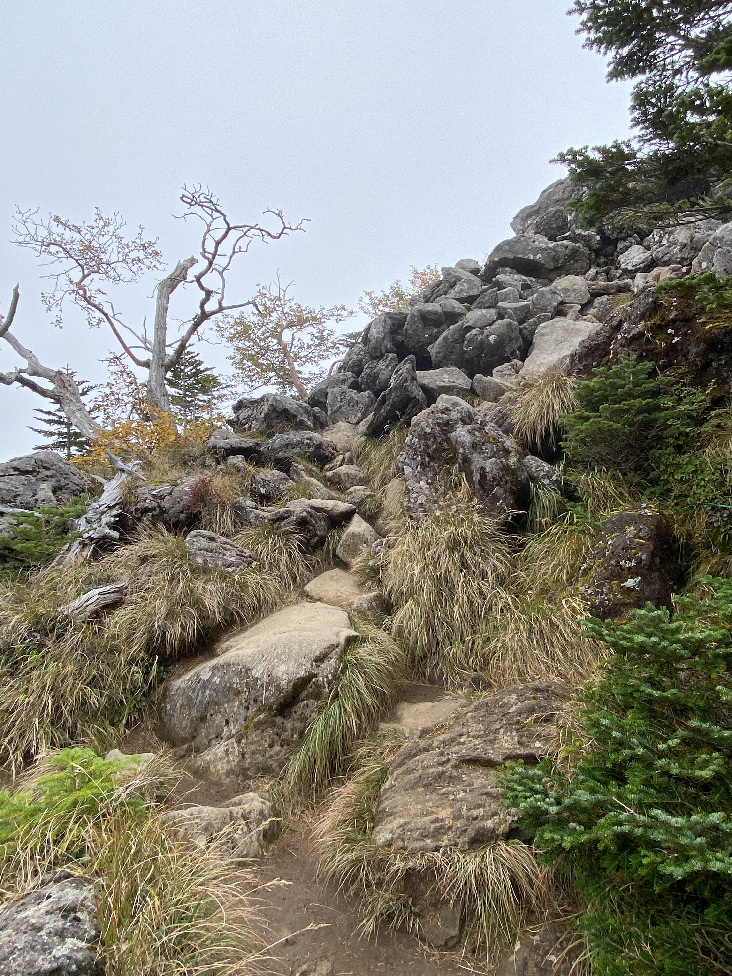
Much of the trail is like this. It would be hard to get lost.
Lots of bamboo grass on these mountains. Bear and deer both like this stuff.
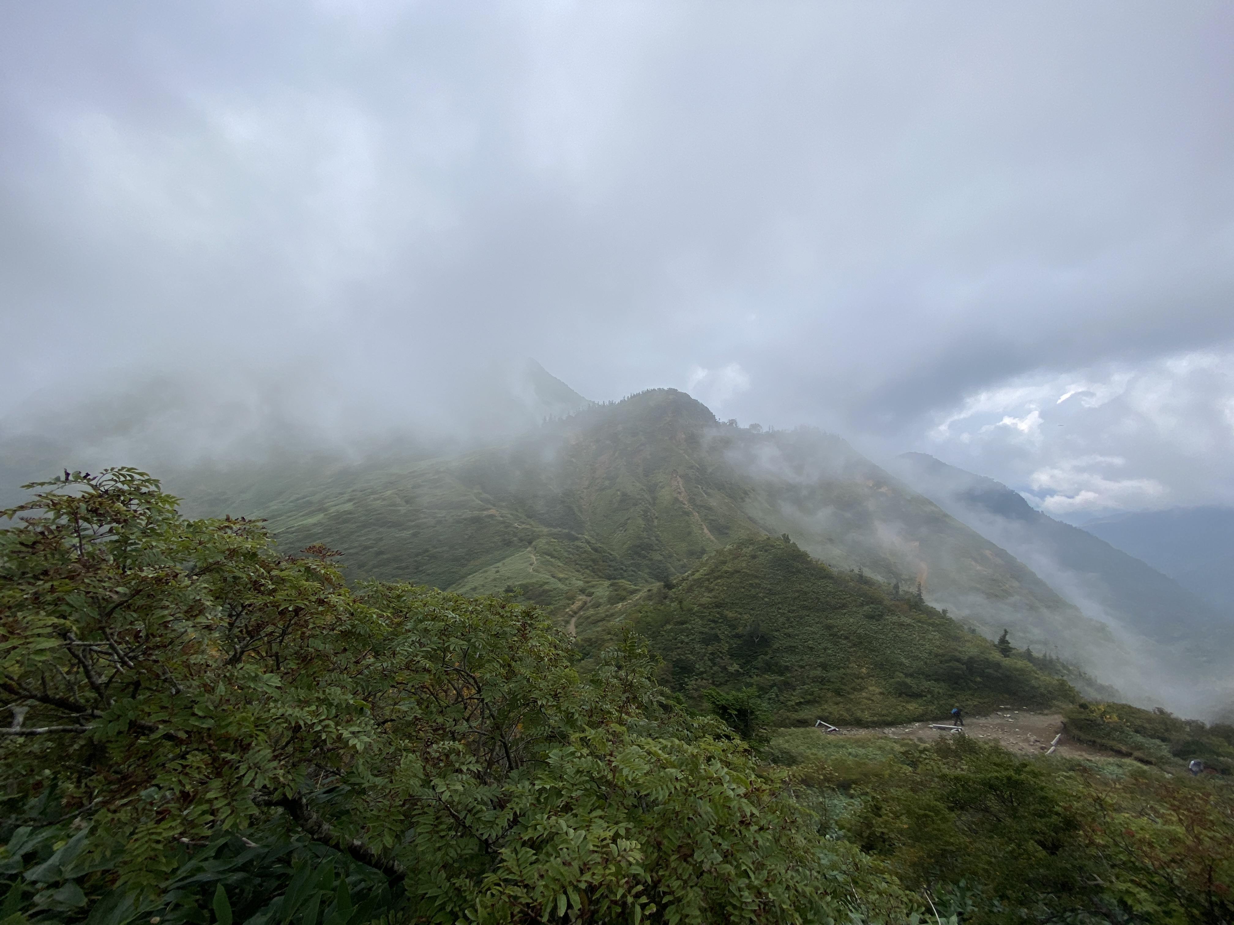
I kept coming upon these scenic overlooks and was left to wonder what I was missing.
The (木のトレイル) wooden trail is long. Much of the flora is wetland and they are protection.
This is Kaguragamine, Mt. Kagura. If the marker wasn't there on the side of the trail, I wouldn't have thought it is a mountaintop.
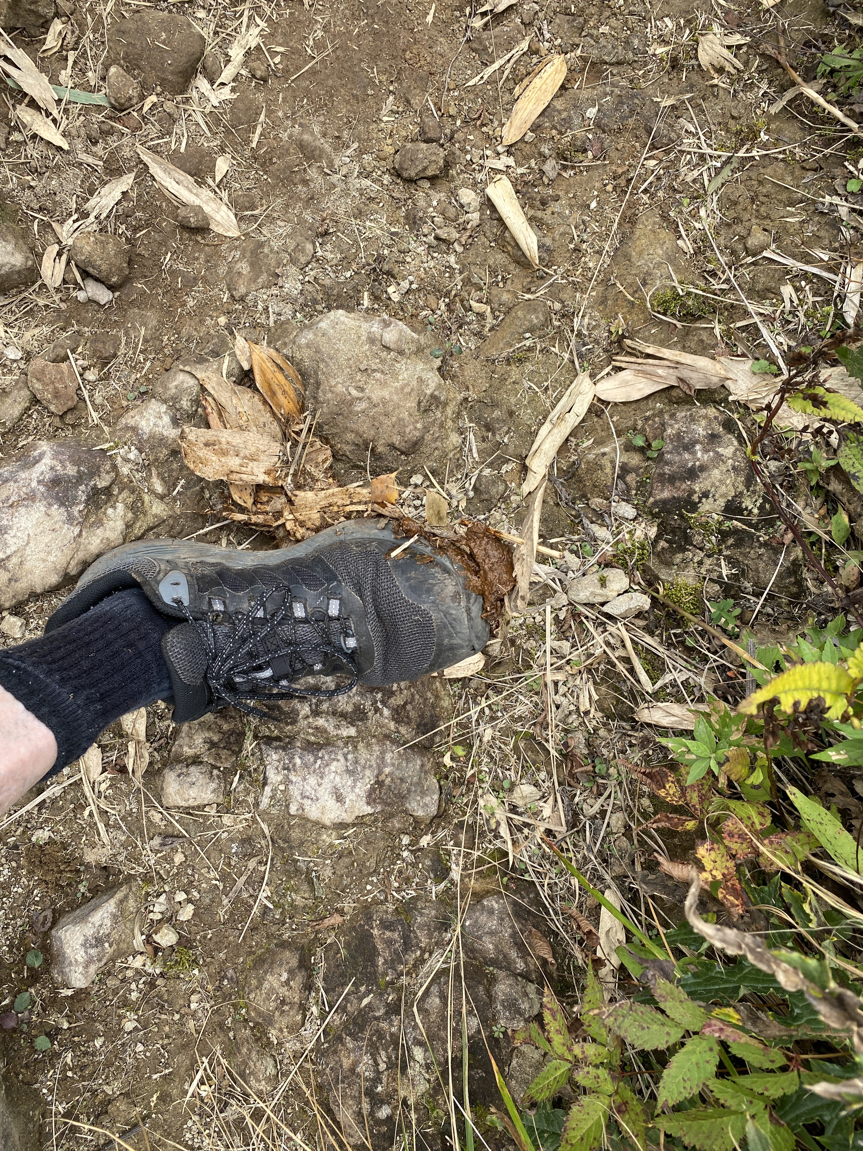
Behind that marker on the side of the trail denoting Mt. Kaguragamine is a narrow path through the thick bamboo grass leading a few meters up to the top of a ridge. It seemed like the likely spot for the actual mountain top and I wanted to take a peek and see if there was a nice view, or another marker.
All I encountered was what I stepped in under the bamboo grass.
There are no dogs around here. I think all I found was Yogi Bear's walkway to his restroom.
The final push up to the top is a steep slope with a climb of a few hundred meters. It is rewarded by this view of this plateau wetland as you pop out of the trail.
Naeba Hut.
Lodging, food, pay toilets.
Note the net wrapped around the blue sheet. It makes me nostalgic for my days doing helicopter slingload operations in the army.
I got off the mountain about 3 pm and piled myself into the car.
You have no idea how happy I was to encounter this river on the road. This type of swimming hole is much more to my liking than an onsen.
This swimming hole is bellybutton deep.
Ice cold.
Perfect.
Oh yeah, that's the ticket.
And no, I will not take a picture of anything above my knees. This is a family blog.
As a bit of a coda/epilogue, here's something I encountered on the road somewhere in Gunma. I have no idea what it is or why it's there but it does seem fitting for the caveman's blog, doesn't it?
Well, cavedwellers, that's it for today. Subscribe, tell your friends about me, send me wads of cash, etc. See you later.
Caveman out.
ps A commenter wanted a picture of the badge I bought on top of Naeba. I'm posting here a pic of my banner listing the 100 Famous Mountains. I pin on a badge each time I cross one of them off. I've climbed 27 of them by now. I'd love to do them all, but I'm not made of money and a lot of them are too far for day trips.
Still waiting for those barrels of cash for being an influencer. How do the Kardashians do it?