Greetings ladies and gentlemen and spelunkers of all ages. Welcome to my mancave.
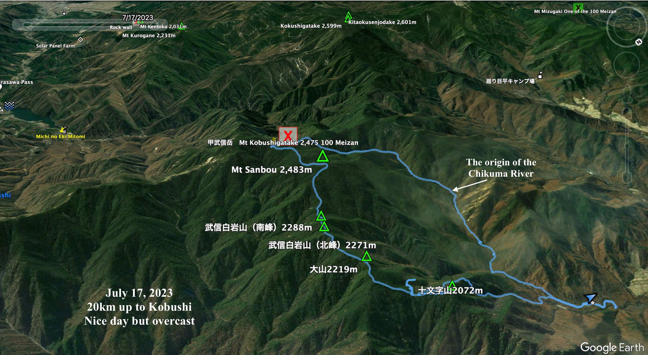
Location: Mt. Kobushi (甲武信岳) in the Tama Kai Chichibu National Park
Starting and stopping point: Mokidaira Parking Lot, Nagano
Peaks bagged: Jumonji ~~ Oyama ~~ Bushinshiraiwa* ~~ Sanpo ~~ Kobushigatake
*The top to Bushinshiraiwa is blocked off
Getting there/getting around: There is a large parking lot at Mokidaira. A taxi there from Shinano-Kawakami Station on the Koumi Line will set you back about ¥6,500 (2019 estimate).
Map: Kinpu and Kobushi Yama to Kogen map
(If that link doesn't work, try searching for "Yama to Kogen Chizu
KINPU・KOBUSHI 金峯山・甲武信" on Mapple's website .)Weather Information: Kobushigatake weather
Total Time: 8:46 Break time: :56 Distance: 20.1 km
Elevation: Lowest: 1,414m Highest: 2,483m Total Ascent: 1,702m Total Descent: 1,702m
Technical considerations/difficulty: There are several steep spots with chains or ropes. You must have your wits about you to not get lost. Most people doing this route stay overnight either at the Jumonji Hut or the Kobushi goya (Hut). It isn't that strenuous, but the stats of this hike bear out that it is longer in distance and has a greater overall change in elevation than the usual hikes up Mt. Fuji from one of the 5th Stations.
Facilities: The parking lot has a public restroom. The Jumonji Hut and the Kobushi Hut provide lodging for the night as well as public restrooms and the usual stuff for sale those places have. I forgot my lunch! It's a good thing I carry emergency food because I found out that there are no convenience stores or anything like that anywhere near the trailheads. (I'm too cheap to buy food at the huts unless I'm really in a pickle.)
Thoughts/observations/recommendations: People ask me all the time, "What's your favorite mountain?" I'm generally at a loss for words because there are so many! It's like being asked where I'm going next. I have no idea. I always have about 20 hikes planned--it just depends on the weather and time available which one I will choose on a given day. I think if I have to shortlist my favorites, though, Kobushigatake would make the cut. This was my 4th time up there and I have some great memories of the mountain so it was nice to revisit it.
The previous trips I took up there were taken when I still lived in Tokyo so I approached it from the south side. Now that I live on the north side, I took the chance to approach it from this side.
The south side can be approached for a (strenuous) day trip from the Nishizawa Keikoku. That is a great area with a michi no eki nearby. Keikoku means gorge or canyon in English. The keikoku by itself is a beautiful, less strenuous hike for daytrippers from Tokyo hoping to escape the heat.
One time I stayed at the Kobushi Hut on the second night of a 3-day hike from west to east from Mt. Mizugaki in Hokuto City, Yamanashi to Nishizawa Keikoku. That was awesome. Mt. Mizugaki, Mt. Kinpu which that trail goes over and Kobushigatake are all 100 Meizan so it was such a great experience.
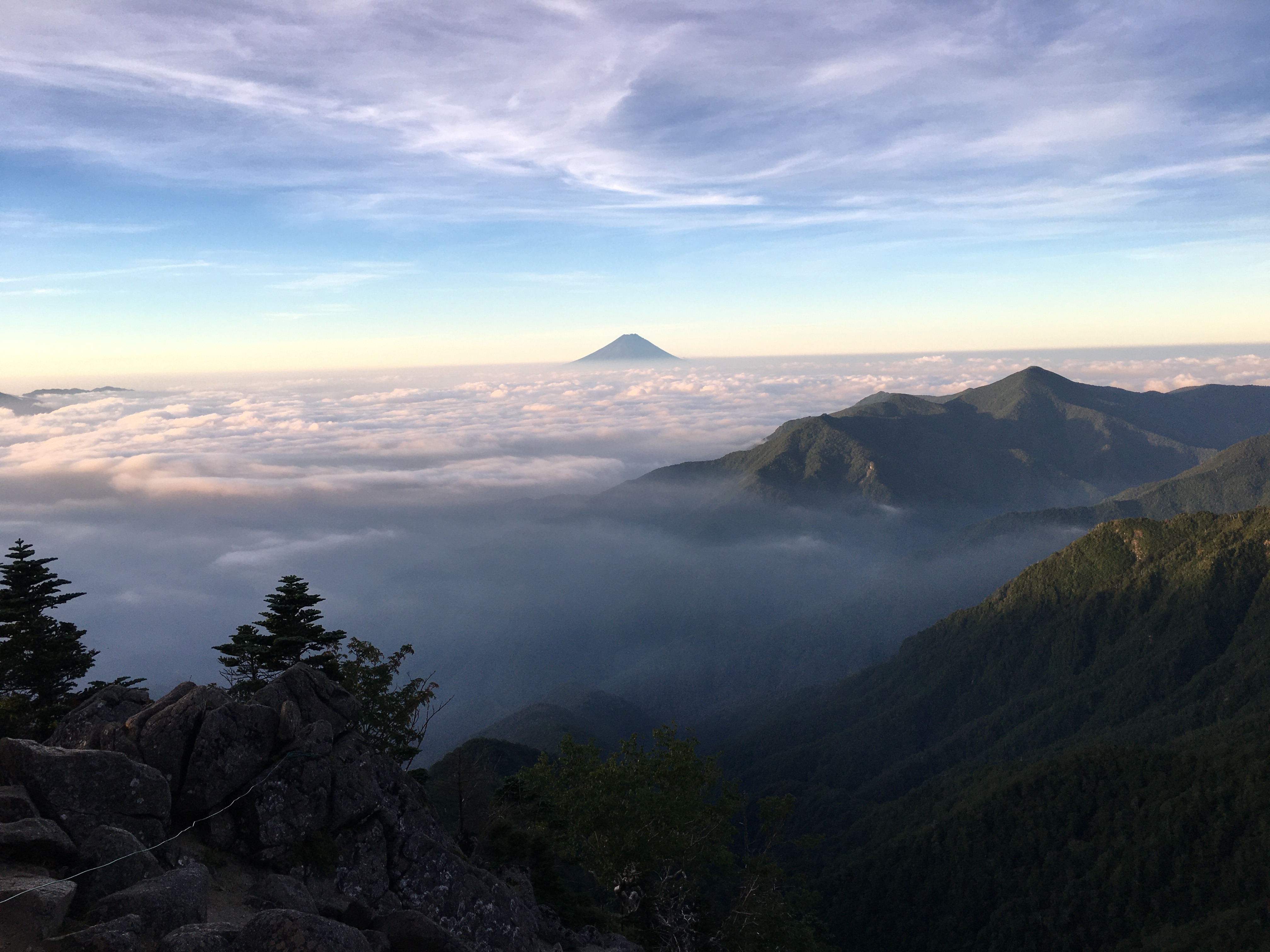
This hike didn't have the greatest weather for visibility so I think I may have to revisit my past excursions to augment the pictures I took yesterday.
Today's listening: Bible in a Year
Let's look at some pictures.
I took this on the way. There are a lot of lettuce fields in the area.
The weather in the morning couldn't have been better.
The Jumonji Hut.
Just prior to passing the Jumonji Hut, I went to the top of Mt. Jumonji. It didn't have any view.
This is one of the few mountain views I got yesterday.
It got cloudier and cloudier as the morning progressed.
There are a lot of rhododendrons around here. (シャクナゲ)
I have no idea what kind of bird this is--but it was cool.
Swag. I bought this at the Kobushigoya. It's a replacement.
The Kobushigoya. I've pitched a tent here a few times.
Up to the top of Kobushigatake. I got robbed of the view.
The marker for Kobushigatake.
These are some old pictures from the same area.
Now, back to yesterday . . .
This puddle is the starting point for what will turn into Japan's longest and widest river. It will eventually flow into the Sea of Japan in Niigata.
The last few hours of the hike are along the Chikuma River which becomes larger and livelier with every step.
Oh, yeah. Oh, yeah. That's what the doctor ordered.
BTW, as a veteran of mountain streams, I have to say this was the coldest one I've been in.
Thank you for stopping by the mancave again. Come again. Don't forget to subscribe and to tell all your friends to subscribe, too.
Want to see another hike to Kobushigatake from another side?
How about another of the 100 Famous Mountains?
That's all for now.
Caveman out.