So pumped to make it to Fuji the other day with my son. This trip is something I've been looking forward to for two years. In 2019, some friends and I had an attempt at Fuji thwarted by weather at the 7th Station. Last year, I couldn't get my revenge on the mountain because it was closed down by COVID.
This year, I was diagnosed with cancer and I was absolutely determined to do Fuji during this season no matter what. (Thankfully, my cancer was taken care of with a couple surgeries. Yay!)
Fuji, having its reputation for being Fuji, made it difficult to find a climbing partner. They do say, "A wise man climbs Fuji once, a fool climbs it twice. "
I don't blame my friends. I swore that I would never do it again after my first ascent about 25 years ago. On that trip, I was beyond miserable. I had a headache, muscle aches, heartache. It was awful.
It was to be expected. I was smoking 2 packs of Marlboros a day. Exercise was walking to McDonald's.
Anyway, my 15-year-old son stepped up to the bat and said he'd come with me. What a gift. Thankfully, he's a jock and I didn't have concerns about his physical condition.
I took something like 360 pictures up there. It's so beautiful and is really difficult to pare down to the best so this post is picture-heavy. I hope they aren't boring for the reader. I always say less is more, but I am kind of like Polonius. (He's the guy who said, "as brevity is soul of wit, I shall be brief"--and then proceeded to talk until the audience nearly fell asleep.)
Before putting up the play-by-play, let me put up some details
Location: The big daddy of Japan, Mt. Fuji
Starting and stopping point:
Akishima, Tokyo/Fuji Subaru Line 5th Station
Peaks bagged:
経ヶ岳 ~ 久須志岳 ~ 成就岳 ~ 伊豆岳 ~ 朝日岳 ~ 三島岳 ~ 富士山(剣ヶ峰)
(First-time) peaks # ----
Getting there/getting around:
There are several ways to get to Fuji. Depending on the hiking route you take and the time of day you opt to go, you'll need to assess whether a car or some combination of train and bus work best for your plan. For most people coming from Tokyo, the Yoshida Route in Yamanashi is the easiest to get to and you can get to it by highway bus to Kawaguchiko Station, and from there taking a shuttle bus to the 5th Station.
Lowest: 2,274 mHighest:3,776 mTotal Ascent:1,720 mTotal Descent:1,714 m
Stuff to think about
Technical considerations/difficulty:
Fuji is truly wonderful. You must be prepared, though. Altitude sickness hits many. Many people who are out of shape and ill-equipped go to Fuji and put themselves and others in danger. At the minimum, they cause themselves to suffer.
It's not that difficult technically or physically on the average summer day. There are many areas with chains or ladders. but there is no place that you need to wear a harness or do any free-climbing. It's steep, but the longest of the usual trails is still under 10 miles. That's not much more than the average day-hike for someone who is often in the woods. When I lived in Tokyo, I was surprised to realize that it was possible to climb it Fuji a day--and get home for a late supper!
The last time I climbed Fuji, I was disappointed to see many un-prepared families. I saw a lot of parents carrying toddlers and many grammar-school-aged kids whining on the side of the trail while their parents yelled at them to get going. There were also families where the kids were fine. (I even saw a hiking club of 7-8 year-olds going all the way to the top. Those kids were amazing! No whining. All smiles.) Please, know your kids' limits if you bring them.
Wear the right clothes. Although Tokyo may be in the 30s (90s in fahrenheit), the top of Fuji at sunrise is near freezing.
***IMPORTANT INFO HERE*** There have been too many hikers in the past year or two and the Japanese are placing restrictions on the times you can hike and on the numbers allowed on the mountain. They are not allowing people to "bullet" (straight up and back without stopping) overnight. If you want to see the sunrise, you'll have to make a reservation and stay in a hut. After 4:00 pm, they won't let you on the trail unless you have a reservation. They are limiting the number of climbers to 4,000/day also. This website has all the information. Please see it for detailed explanations. Official Fuji Site
Facilities:
There are facilities all over the place--but they were a bit overwhelmed in 2023. Bring money for the pay toilets. There are lots of snacks/meals/drinks to be had on the mountain. Just remember that the higher you go, the more the prices rise.
Sunrise is really wonderful on Fuji. Many people start in the late afternoon and stay at one of the mountain huts for a few hours at one of the mountain huts before making the final assault. This enables your body to get acclimated and lessens the chance of getting altitude sickness. For this trip, I stayed at the Taishikan (Fat Child) Mountain Hut.
Thoughts/observations/recommendations:
I am so blessed to have been able to climb fuji and it environs so much. I hope you can do it, too!
Now, back to the original post.
New video here
7:00am August 1
Pointing at Fuji from home. (Really)
Remember that stick. It's important later.
This picture is the Fifth Station of the Subaru Line. All the trails waystations are numbered. Most people start hiking at the 5th Stations. Most of the trails have 8 stations before the top. One has 9. This is a very busy place. The Subaru Line is the most popular trail and this place can accommodate more tourists than you can imagine. The higher stations are nothing like this. Usually not much more than a shack chained to the mountain with rocks on top to keep the roof from blowing away.
The suggestion is to hang out here to get a bit acclimated to the elevation before proceeding. We left here at 11:30. It was suggested we get to our lodgings at the 8th Station by 4 or 5 and we were told it should take 4 or 5 hours to get there. (We made it there by 2.)
The route:
The weather was kind of unsettled on the way up on the first day so I didn't get too many good pictures. If the clouds opened up for even a second I whipped out my iphone.
This is where we stayed, the Taishikan. ("kan" means something like hall. "Taishi" was the name of an emperor or prince that was said to have rested his horse at this spot on his way up Mt Fuji in ancient times. If I were the horse and I had seen what was coming next, I would just have refused to go on.)
Interestingly, at 3,100 meters, it is already higher than the second-highest mountain in Japan which is a mere 3, 050 meters in elevation.
These mountain lodges are places where people rest for a while before making the assault on the summit for the sunrise.
Here are some pics of the interior. (Make sure not to miss my videos of the restrooms. Those are a hoot.)
In the past, everyone slept in a huge room. Now because of COVID, it's kind of like a rustic capsule hotel. I banged my head every time I got up.
A traditional irori. I read somewhere that the Taishikan is still using a pot from the 17th or 18th century.
Remember the stick from the first picture? You don't? Then maybe you have CRS or ADHD or, you might be POTUS.
Anyway, the walking sticks are a great money-making scam for the tourist businesses. As you go by the different lodges, they will brand them for you with that place's particular stamp for ¥500. Here I am getting mine branded by one of the staff at the Taishikan. (I say it's a scam, but I like having the stamp.)
Make sure you check out the video and its explanation, too!
After dinner (curry, at 4pm), we tried to rest. I was able to get an hour's worth of sleep I guess. My poor son, who hasn't had the chance to develop the skills I did in the military didn't get any sleep.
We got up around 1am and headed off for the top. It was a little earlier than necessary, but we had nothing else to do.
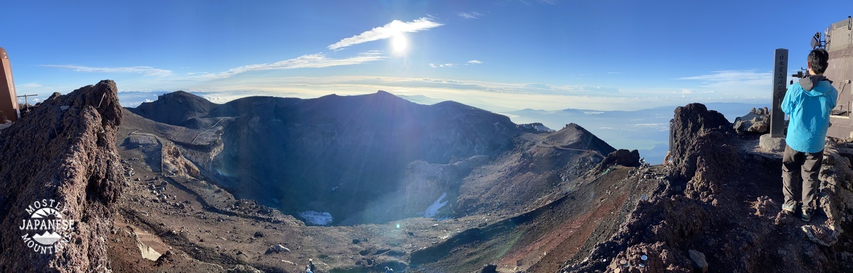
We got to the top around 3:30. There was no one there. Pitch black. We had nothing to do but pick our spot to wait for the sunrise.
Seeing how Tokyo is in the 90s these days, the top was a bit cold for us at about 3 C (38 F). It was worth it. What a show. I am also glad we were able to pick our spot. By the time the sun came up, it was nearly standing room only.
Again, make sure to check out the video. Hear authentic Japanese people really say "Banzai!"
After shivering for nearly two hours waiting for the sunrise, we were ready to move within about a minute of the appearance of that sublime disc. Then we took a walk around the caldera.
Looking south toward Gotenba. That black bump is Mt. Hoei. I was able to climb that on my last trip in 2019.
(2019)
The route we took that year.
(Back to this year.) We got around to the top a little before 6.
I am so proud of my son. He hiked the highest mountain in Japan on no sleep in new boots and didn't complain once.
I got such a kick out of this. I wonder if real estate that falls within the shadow is cheaper.
I hope you enjoyed that. I know I did. I need to stop blogging now and get packed for tomorrow's hike.
S'up cave lovers? I want to share with you some of the places around Mt. Bandai in Fukushima. As I said in the last post, aside from the mountain, there are a lot of recreational things to do here.
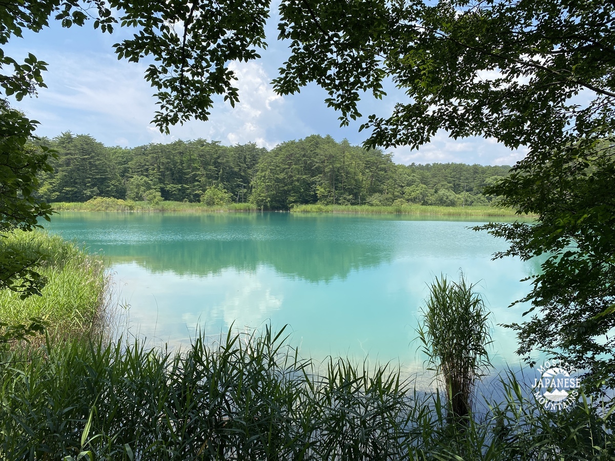
The volcanic eruption greatly interrupted the drainage of the area and created numerous lakes and marshes. These first few pictures are of the Goshiki Numa, "5-colored Marsh", (五色沼). There is a fairly flat walking trail of about 4~5 km through it. Along the way there is a restaurant, an ice cream stand, a souvenir shop, and rental boats. Great fun for kids from eight to eighty!
Some of the watery sights in the Goshiki Numa.
There are some well-fed, well-coordinated Koi here.
The next place I'd like to share is the Matsubara Campground on Lake Hibara. The Matsubara Campground is a great place. It faces the mountain across the lake and the views of Bandai are just incredible. It also offers a front-row seat to the annual fireworks display held over the lake. (Unfortunately, that display has been on hold since the COVID era began.) The campground has swimming, tenting, cabins, boats, canoes, kayaks, fishing, bicycles, hiking, cooking facilities, water, a bath, great bathrooms . . . and they pick you up in a boat to bring you to the campground! Since there are no cars it offers a more serene experience than the usual car-camping lollapalooza.
The owner is a descendant of one of the 4 people that survived the eruption in 1888 and likes to show old pictures and tell the story.
Their website it here:
http://www.urabandai-camp.com/
Note the slide and the rope swing on the left. The water is so clean. I dropped my glasses in about 10 feet of water but was able to spot them from the surface. There are lots of fish to see, too.
Since I'm a walker, even after climbing the mountain, I was happy to have the trail along the lake to perambulate. There were some spots along the way that were just so beautiful I couldn't help but linger to look.
The water is very high compared to my last trip. Then, these islands were above water.
Mt. Bandai, in Fukushima, is a really beautiful, interesting mountain. It's shape and the topography all around it is the result of massive volcanic eruptions in the past. The latest eruption, in 1888, nearly wiped out the entire local population--all but 4 people who were out of the area for work at the time perished--eradicated a mountain peak, stopped a river, and created numerous swamps and lakes. Along with the mountain, these spots offer innumerable leisure opportunities from hiking and boating to ice fishing and skiing.
I think I will make another post about the stuff below the mountain in the near future.
It's my blog. I'll post about whatever I please. ;-)
This is a view of the north side of Mt. Bandai from our campground on Lake Hibara. Bandai is the higher peak on the right.
I was a bit nervous about this trip. The weather forecast was for thunderstorms, hail, brimstone, frogs, locusts, bats from Wuhan . . . This was my third trip up to this area. The first time it rained so hard, I just stayed in the campground the whole time. My first climb up Bandai was two years ago but this is all I got to see from the top.
Thankfully, the weathermen were wrong. It was gorgeous. Who says you need a weatherman to know which way the wind blows?
Our route:
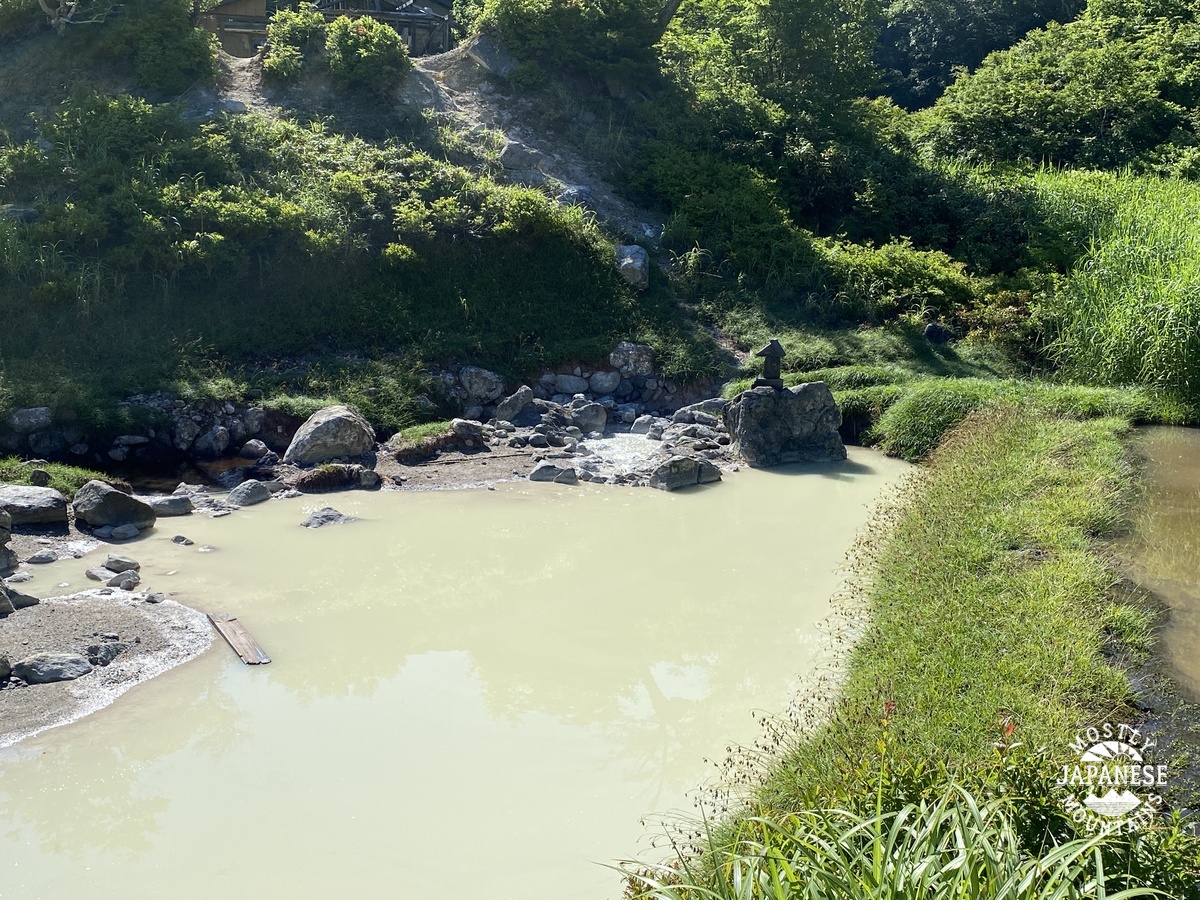
That is a hotspring we encountered on the trail. There used to be public bath here. This spot is called Nakanoyu (中の湯).
It smells like hell. Really. It's the smell of sulfur.
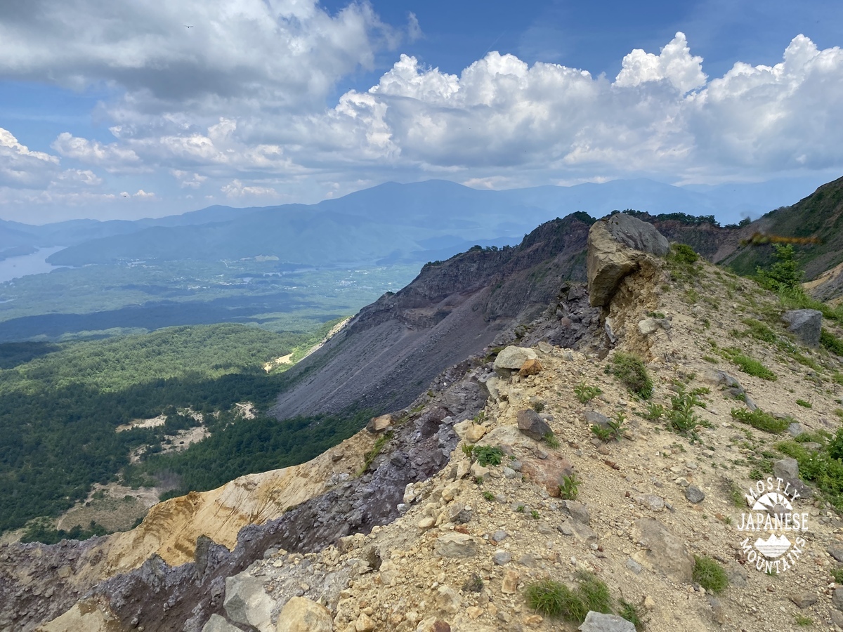
From the top:
Looking south to Lake Inawashiro, the largest lake in the area.
Much better view than the last time!
There were a lot of dragonflies on the top.
This is Kevin, my sherpa.
When we were coming down, it was something to imagine that there used to be a mountainpeak towering here. Kevin kept saying, "The mountain blew up."
I hope I didn't post too many pictures for you. Less is more but it was really difficult to keep the number of pictures down. It's such a beautiful place.
More soon. Like I said, I think I'll make another post about the area below the mountain. Take care of yourselves.