Showing posts with label 長野、群馬、荒船. Show all posts

Burning for Boulders. Rosoku Iwa. Gunma/Nagano.


How's it goin', cavecritters?

I had the chance to get into the woods for a little bit before work this morning.

I went for a peek at these boulders called Rosoku Iwa (ローソク岩 --"Candle"-"Boulder" in English.)  There are three boulders.

Mrs. Caveman made an observation the other day.  She said some people go bird watching, but I go mountain watching.

I guess you could modify that and say that I sometimes even go rock-watching.  
Wow.  Rock-watching.
How pathetic is that?

(They were really cool-looking rocks, though.)

For my next hobby maybe I'll take up watching grass grow or paint dry.


I am so glad I ignored the weatherman this morning.  He's been forecasting rain for the whole week but it was beautiful outside.

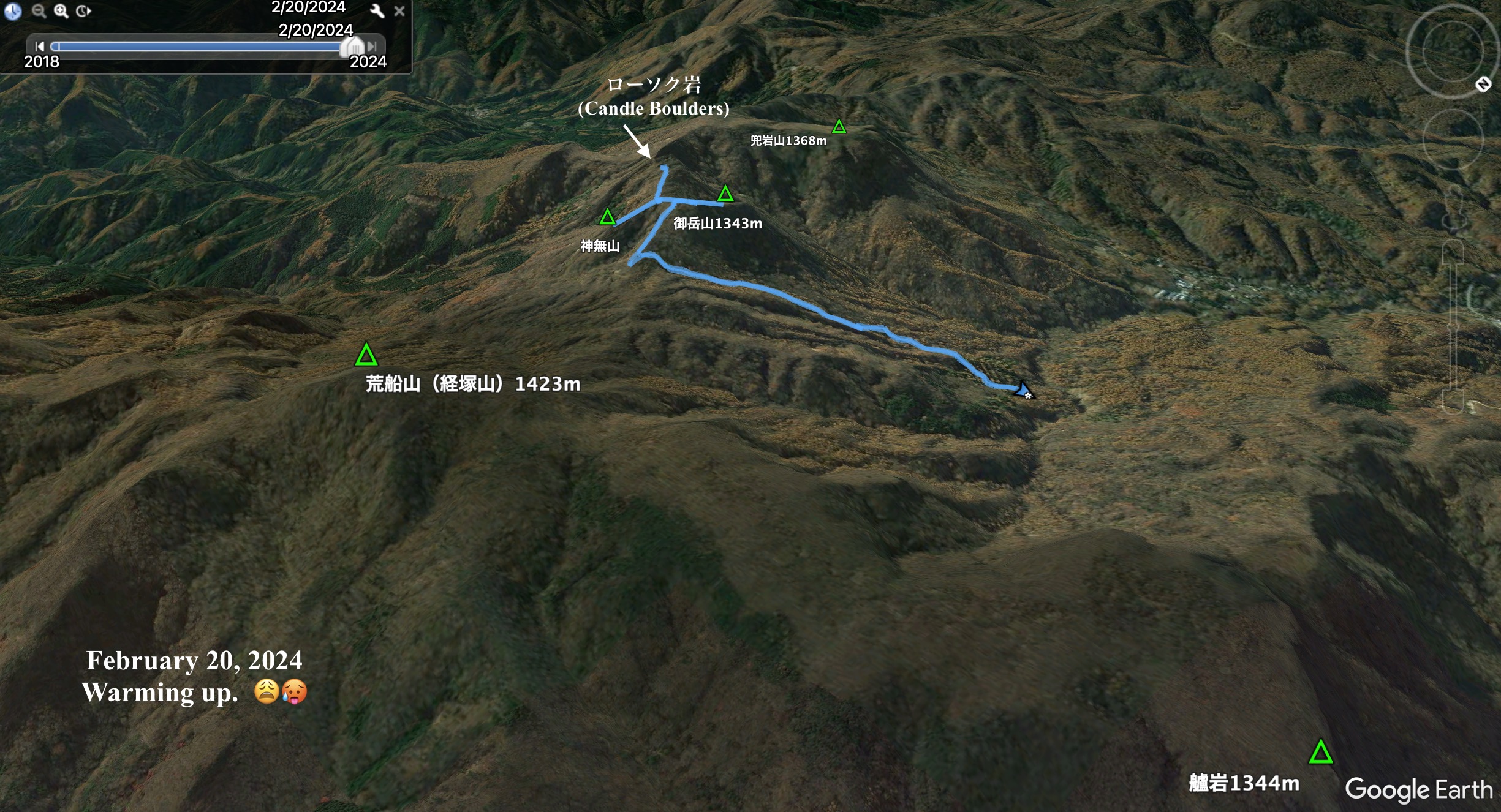
Location: Straddling Saku-shi in Nagano and Nanmoku in Gunma 

Starting and stopping point: Parking lot below Fudoson Shrine 荒船不動下駐車場 

Peaks bagged: 御岳 (Ontake) ~~ 神無岩 (Kaminashiiwa)

(First-time) peaks # none

Getting there/getting around:  I drove.  It's a narrow, winding road off of the Cosmos Road.  If my name were Paul, I might say it's a Long and Winding Road.  


I'm sorry.  I was just trying to be punny.

Map: Yama to Kogen Chizu 19 浅間山軽井沢・長野原の山々ASAMA-YAMA KARUIZAWA-NAGANOHARA-MOUNTAINS

Weather Information:  Asama Weather

Total Time:  2:01 Break time: :00  Distance:  3.9km

Elevation:  Lowest: 1,037m Highest: 1,350m Total Ascent: 453m  Total Descent: 453m

Technical considerations/difficulty:  These hills are not really high but demand your full attention.  The ridgeline is as sharp as a knife in places and the ridge falls away steeply on both sides.  There are a few spots with chains or ropes.  I was hiking after most of the snow had melted so there was quite a bit of mud.  That made for slipperier conditions than if it were snow-covered because I couldn't make use of crampons.  If conditions were better, I probably would have gone just a bit farther to be able to see the Rosoku Iwa from all sides but decided it wasn't worth it.  At that point, the trail was in the shade and covered with snow.  The trail there was quite narrow and just hugged the side of a really steep hill.  

The Rosoku Iwa(s) themselves are not really for hiking.  The trail passes around them but getting to the top of two of them entails actual rock climbing and necessitates all the equipment incumbent on that kind of adventure. 

Facilities:  Nothing.  You may be able to get some water from the stream, but there's nothing up there.

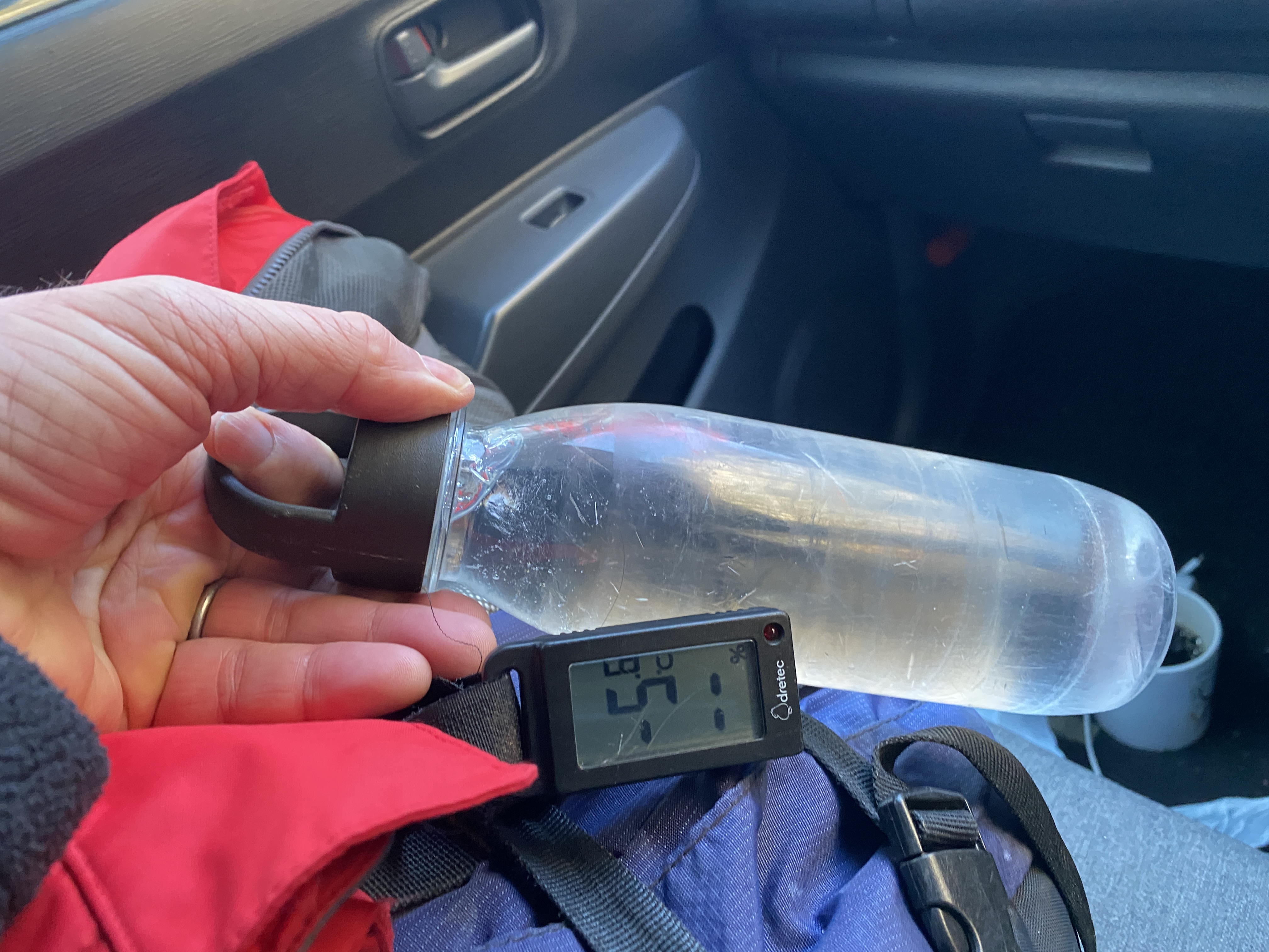
Thoughts/observations/recommendations:  Like I said, I'm glad I ignored the weatherman.  If I had slept in today and then walked out into the sunny morning that it turned out to be, I would have been bummed out.

This was my 3rd or 4th time to this area.  Sometime soon I will have to get to the nearby 立岩(Tateiwa) "Standing"--"Boulder".

I'm so bummed out the snow is melting so quickly around here.  I'm going to have to drive a bit far to get to snow.


Here are some pictures:


This is just before the peak of Mt. Ontake.  I'm sure many people mistake it for the peak.


Mt. Asama is in the distance in the middle of the picture.


Rosoku Iwa is actually 3 places named P1, P2 and P3.
P stands for peak.  h/t to Naresh Deora.

This is P1.


This is P1.
I could climb to the top of this one.
I didn't even realize that I had climbed P1 until I saw a picture of it on another blog.

It was a bit dizzying and climbing off
of it was a little unnerving.


I was on that one on the left, Kabuto no Iwa, a few weeks ago.


I got as far as just beneath P3 and turned back.
The trail was pretty slippery--(and I was already in
danger of being late for work.  Shhhh.)


I'm grateful for the chain.
Pictures can't quite capture how narrow and how high this ridge is.


Saitama's Mt. Ryokami is in the distance.


Well, that's it for today.  The last pictures are pics with mountain names labeled on them in case
any of you are geeks like me with an interest in knowing the names of mountains.
If not, you can stop reading now.

Subscribe.  Tell your friends, etc.
Or not.  
You do you and the caveman will do the caveman.  (Hey, I think
I just came up with the name of the next new dance--The Caveman!  It'll be bigger than the 
Macarena or the Monster Mash.)

Caveman out


Mt. Kabuto Iwa--Helmet Rock


Location: Mt. Rockhead  (That's not really the name, but it's close.😂)

Starting and stopping point:  Taguchi Pass 田口峠

Peaks bagged: 兜岩山 (Kabutoiwa)

(First-time) peaks # XX

Getting there/getting around:  I drove.  There's no public transportation.

Map:  Yama to Kogen Chizu #21 西上州 妙義山・荒船山

Weather Information: Mt. Arafune's weather (not too far away)

Total Time: 2:00  Break time: 0:00  Distance:  5.8km

Elevation:  Lowest: 1,107m Highest: 1,368m Total Ascent:  464m Total Descent: 464m

Technical considerations/difficulty:  It's not a terribly demanding hike.  There are no chains, ropes or ladders.  Much of it is along a very steep ridge.  I would not want to fall off the ridge!  The trail is not marked or traveled very much.  I would encourage not coming on this hike without some sort of GPS because you could get disoriented and start following the wrong ridge.

Facilities:  Nothing.

Thoughts/observations/recommendations:  

This was a hike to 兜岩山 (Kabuto Iwa Yama).  Kabuto means helmet and Iwa means boulder.  That's why I think of it as Mt. Rockhead.

It's almost a scenic hike.  There are gorgeous scenes hinted at all along the way but the trees are just a bit too thick to ever give an unobstructed view.  It was fun, nevertheless.  I did see some wildlife on the way.  As I pulled up to where I parked, there was a smallish critter on the trail I was about to hop on.  I think it was a marten, but I did not get a good look.  On the trail, I caught a glimpse of a bevy of about 5 does about 100~200 yards away.  They gave themselves away by barking at me.

There wasn't enough snow to necessitate wearing crampons but it was frozen crisply enough that it gave a satisfying crunch when stepping on it. 

Mrs. Caveman bought me a nice pair of winter boots for Christmas.  Wow.  I like them.  When I think of all the years of my life having cold feet in the snow and cold, I feel spoiled now.

This trail is not used much so it was pleasant to see no (two-legged) footprints other than my own.  I did see plenty of pawprints on the trail.

I chose this route for the distance and time available.  I frequently go for short hikes before work but was getting bored with the same areas.  I wanted to do one that was a bit more substantial--yet still get to work on time.  So I decided to pick just one of the peaks near Arafune for a piston (out and back on the same trail) hike.  The trailhead is a half-hour drive from home and the route I chose was about 6km (about 3.5 mi.).  I figured that if I started before sunrise, I could make it there and back and get to work by about 9:30.  It worked out fairly well.  I was able to do the hike and get home with about 10 minutes to spare to get ready for work.  Perfect.  Score one for the caveman.

The trailhead is just before the prefectural boundary between Nagano and Gunma at the Taguchi Pass** on Route 93.  (**One of the reasons I like hiking is that I get to use the word, pass.  I always feel like I'm in a western and my posse is going to head some black-hatted bandits off at the pass.  But I digress.)  Route 93 is a very narrow mountain road and is a great place to go spotting deer at dusk.  I had reason to get worried on the road this morning, though.  There were signs saying that the road was "closed end to end between the hours of 8-12 and 1-5 for maintenance for this week."  I decided to push my luck and try to drive on to the trailhead.  I didn't see any construction equipment on the road and hoped that all of the maintenance was going to be on the other side of the pass and wouldn't actually affect my side.  I knew I wouldn't finish my hike before 8 so I was taking a risk.  I was imagining how to beg in Japanese for passage back out of the mountains in case they closed the road behind me.  ("Road closed sign?  Is that what that sign meant?  I'm sorry.  I don't read Japanese."  No.  I can't lie so well.   [That's a lie, in case you're wondering.]  Maybe I would go with "Please, let me out.  I'll never do it again.")  Then I was imagining not being allowed passage back to civilization.  What would I tell my employer on the phone--assuming there was a signal out there by which to make the call?)  Thankfully, I had no problems getting home.  I didn't see any road crews on my way home and no gate or anything was blocking the road.

OK.  It's official.  I'm doing the thing bloggers do that I hate--telling me about themselves.  You don't need to know all this--the same way I don't need to know about how every time Sally the baker makes cornbread she remembers how her grandpa used to talk about his boyhood days back in Nebraska when he used to sit on his grandaddy's lap on the tractor and really loved the smell of the cornfields of the back 40 in July . . .  I just want her stupid recipe for cornbread!  

I swear.  Sometimes you have to wade through about 20,000 words before you get to a recipe on a food blog.  I shouldn't subject you to that same kind of treatment.

So, without further ado, I will shut up.

Today's listening:  Just the birds in the air and deer barking on the ground.

These are the details:


Sunrise was at 7:00.  I started at about 6:45.


That road through the valley below is Rt. 254, the Cosmos Road.  The bridge in the foreground is by the Uchiyama Pass Tunnel.  Trailheads for Mt. Arafune and Mt. Monomi are near there.

I live in that cluster of civilization not far from where Route 254 comes out of the mountains.


-9.7 Celsius about 15 degrees Fahrenheit.
I still managed to work up a sweat.


That flat thing with the cliff to the left is Mt. Arafune.


Rosoku Iwa (Candle Rock)


It had warmed up before I got to the car but my water still froze.


The Northern Alps are hidden in clouds.


That's all for today.
Caveman out.