Map: ***The Caveman is giving up on posting links to Yama to Kogen maps. They go out of date after a year or so and the links die. If you want a link to their latest map, comment and I'll get you a link to their latest map of the area.
Elevation:Lowest: 1,466 m Highest: 1,818 m Total Ascent: 568 m Total Descent: 568 m
Technical considerations/difficulty:
Not many ropes or chains. Nothing really dangerous. The trail has many areas of high grass and/or sasa (bamboo grass). This makes the trail hard to see sometimes and on a day like this one when there had been some rain really makes your feet wet.
Facilities:
Nothing
T
houghts/observations/recommendations:
This is one of Yamanashi's 100 Famous Mountains. I know you can see Fuji on a clear day. Unfortunately, I did not see much of anything on this hike.
The hike from Shinshu Pass to Yokoo isn't that taxing and would be nice on a clear day.
Sorry if the next few pictures are too busy.
I wanted to connect the dots with a hike I'd made two months earlier from Hisawa Pass to the west to Tofu Rock so I went as far as Tofu Rock on this particular hike. I wouldn't recommend doing that--unless you have some O.C.-type desire like I do to connect the dots. The trail between Mt. Yokoo and the two Mori mountains to the west is a bit of a slog.
That track was of a bike ride I made from home to the Mt. Mizugaki area. Mizugaki is one of my favorite mountains.
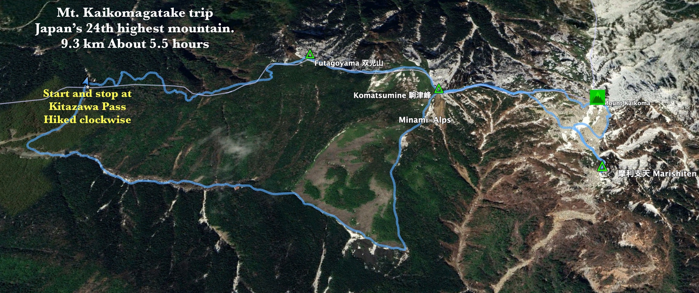
This is a report on Mt. Kaikomagatake, the "Prince of the Minami Alps."
It's a popular mountain--with very good reason!
Area:
Northern section of The Minami (Southern) Alps. Ina City, Nagano and Hokuto City and Minami Alps City, Yamanashi
Location:
Map: ***The Caveman is giving up on posting links to Yama to Kogen maps. They go out of date after a year or so and the links die. If you want a link to their latest map, comment and I'll get you a link to their latest map of the area.
100 Famous Mountains: Higashi Kaikomagatake 東甲斐駒ケ岳*
*Kaikomagatake shouldn't be confused with Kisokomagatake. There are two mountains named Koma (Chess piece) gatake (peak). One is in the Central Alps, or Kiso Mountains. Kaikomagatake is in the adjacent Southern Alps, a region that used to be called Kai. (Got that? There may be a quiz and your life might depend on correctly answering.) The two mountains are roughly the same height and straddle the Ina Valley. Kisokomagatake is also one of the 100 Famous Mountains. This is the link to my report on Kisokoma.
Getting there/getting around:
The first thing you need to do is get to Todaipark (戸台パーク) so that you can get the bus to Kitazawa Pass. (¥1,370 one way, ¥2,740 roundtrip). There is ample parking there. It costs ¥1,000
I think you can get to Todaipark by bus. Here is a link to Ina City's page with JR info and Japan Rail's (JREAST) page with their info. I am glad I could drive. Trying to puzzle through those timetables makes my head hurt.
Elevation:Lowest: 1,982 m Highest: 2,967 m Total Ascent: 1,224 m Total Descent: 1,223 m
Technical considerations/difficulty:
This isn't a terribly difficult hike. There are many exposed areas and there are ropes, chains and bouldering areas but I didn't feel too taxed. It was a fairly fair day, though. Perhaps it seemed easier than it actually is because I was so happy to have at least some blue skies for a change.
There is one trail represented on the map by dotted lines for the last push up to the peak. The dotted lines on the map represent a "variation route" and encourage caution. I took that route rather than the regular trail because it was getting crowded and I am impatient. My instinct was right--the variation route wasn't that hairy and I started out making great time. Then, about a quarter of the way up that trail, I encountered a woman who was a bit concerning. She was looking up a chain in front of her and then looking back at where she'd come from. She was a bit worried about this route. I said, "Let's climb together." That was enough to get her up to the top. It meant losing some time, though.
Speaking of time . . . it is a factor. The bus ride to the trailhead takes about an hour. The schedule is like this: first bus leaves at 5:30 am. There is another at 6:30 and then another at 8:05. The last return bus is at 4. The first buses in the morning seem to have been exceedingly crowded and many people who had lined up for the 5:30 or 6:30 buses had to wait a significant amount of time for extra buses to come after the first ones had filled up.
I'm kind of fast. I took the 8:05 bus and was at the return bus stop about 2:45. (The 8:05 bus wasn't crowded and neither was the trail when I started hiking. Here's one time being late paid off! 👍 The people who went early didn't catch the worm, they caught traffic.) The woman I had met at the dotted line trail had come on one of the earlier buses and I don't know if she was going to make the last bus home. After I deposited her on the peak of Kaikomagatake, I went over to another peak before returning to the trail down. On the way down, I passed her and she seemed to be going slow. Oh well, there is a mountain lodge at the bus stop. Perhaps she had a reservation for the night?
Facilities:
The Senryuso adjacent to the Todai Park Bus Stop has an onsen (¥800), restaurant and lodging. Parking costs ¥1,000. You pay on the way out.
Komorebiso is a lodge at the Kitazawa Bus Stop. No campsites. This would be a logical place to stay if you wanted to climb Kaikomagatake on one day and Senjogatake on another.
Kitazawa Bus Stop has a pay toilet.
There is a booth for portable toilet usage on the trail. (Make sure you keep reading this post to see the picture. It's a hoot. I promise.)
There are two other lodges I passed on the way. They had tent sites and water.
Do it. This is a wonderful mountain. If only there were 366 days a year to climb mountains like this one.
Let's get to some pictures.
I have seen Komagatake from the Yamanashi side many times and it is really impressive. Looking at it from the east or northeast, it is very prominent and on a clear day it's whiteness stands in stark contrast to the blue sky.
Unfortunately, for the life of me, I cannot find a good picture that I've taken of it. The perspective of this picture is not only obscured by clouds but it also makes Komagatake look smaller than the mountains around it.
Remember I mentioned Kisokomagatake? Here it is:
A bus
Timetable
On the long, winding road into the mountains, we could get glimpses of the scenery.
Anticipation mounted. (On the way up, the left side has the best view. You're welcome.)
At one point, the driver stopped and pointed out something called the Shikanomado--("Deer Window").
That's a cave that is captured (poorly) in these pictures.
Here's another view from my iphone
I hope you're taking notes.
High Points 1 and 2 will appear on the test.
This is at the Kitazawa Pass Bus Stop
At the Kitazawa Bus Stop, I encountered this sign. Do you remember Points 1 and 2? They are referenced on the sign. I wasn't going anywhere near any of those places today, though.
Using red for Japanese is super-duper emphatic. It's kind of like screaming in print.
北沢峠 Kitazawa Toge ("North" "Stream" "Pass")
Starting out!
It was so nice to be entering a trail on a sunny day for a change.
Thankfully, after I passed 5~10 people I was alone for the next hour or so.
The name of the lodge at the pass is Komorebi. That word means sunlight filtering through trees. As I walked up this part of the trail, I reflected that it was very aptly named.
There was a lot of blue in the sky but never without some clouds. Even so, it was a great improvement over the recent past.
Are you ready for some potty humor?
There's the top
Chains. ⛓️ 👍🤓
Not far after the second peak, there was a fork.
Everyone was turning right. I turned left onto the dotted line "variation route." I knew it would be a bit more spicy so I assumed I'd avoid a lot of traffic.
Not too far up this part of the trail, I encountered someone who needed encouragement. I stuck with that person until we hit the peak.
Looking up to the top....
Looking back on a ridge I'd just come up.
We made it to the top!
I think they're out of order.
A lot of this landscape reminded me of Star Wars
Last peak of the day, Marishiten (摩利支天)
⛓️
I got to the bus stop at about 2:45. The next bus was scheduled for 3:00. There were already a lot of people ahead of me so I wasn't able to get a seat on a return bus until 3:30.
On the way down, the right side of the bus has the better views. (You're welcome again.)
Upon reaching the terminal bus stop, I was happy to buy some swag (t-shirt) and hop in the onsen before driving home to Mrs. Caveman.
Life is so good. I hope you have something in your life that gives you half the joy that mountains give me.
Well cavedwellers, that's all for today.
I hope you have subscribed. Leave a comment or two. Tell your friends about this blog--or not. I know that hiking in Japan is kind of a niche. 🤓
If you want to see more of the Southern Alps, check out Kitadake or Senjogatake