*After I did this, I found out that I was actually trespassing on the ski area I traversed and that the authorities and owners don't want anyone to do that. I was copying a plan someone else had used. I assumed it was ok because, although there were signs on all the surrounding trails saying no entry, there were no warnings on that route. Evidently, the authorities didn't think it necessary to put warnings there because it's private property. They don't want anyone going anywhere near the peaks of Shirane from any route at all.
I chalk this up as one more thing in the mountains that I wouldn't do again--but that I'm kind of glad I did.😜 You, dear reader, know better than I did though. Do as I say and not as I do. Don't do it.
Car. The place I started is on a toll road. ¥1,070 to get in and the same amount to get out. Can't get around the toll--except if you go early in the morning before the booth is manned, I'm told.
There is a Seibu bus stop where I started. According to the sign on the bus stop, dated last November, a bus stops there three times a day. I can't find the bus route on googlemaps, though. I think the bus probably does still run, but Seibu hasn't told google. That's often the case with local bus companies. I can't puzzle through Seibu's website either.
Lowest: 1,423m Highest: 2,071m Total Ascent: 847m Total Descent: 847m
Technical considerations/difficulty:
It's steep. For most of the hike, I was walking straight up abandoned ski slopes. There are no ropes, chains, ladders or boulders to negotiate. There are two spots where you aren't following ski trails and you have to pick your way through unmarked forests. I needed my GPS there. Other than those spots, you'd have to be blind as a bat to get lost. There're really no windbreaks. I got a sunburn. I should have remembered sunscreen.
Facilities:
Nothing on the hill. Nothing open, at least. The abandoned ski lodges and lifts are still there.
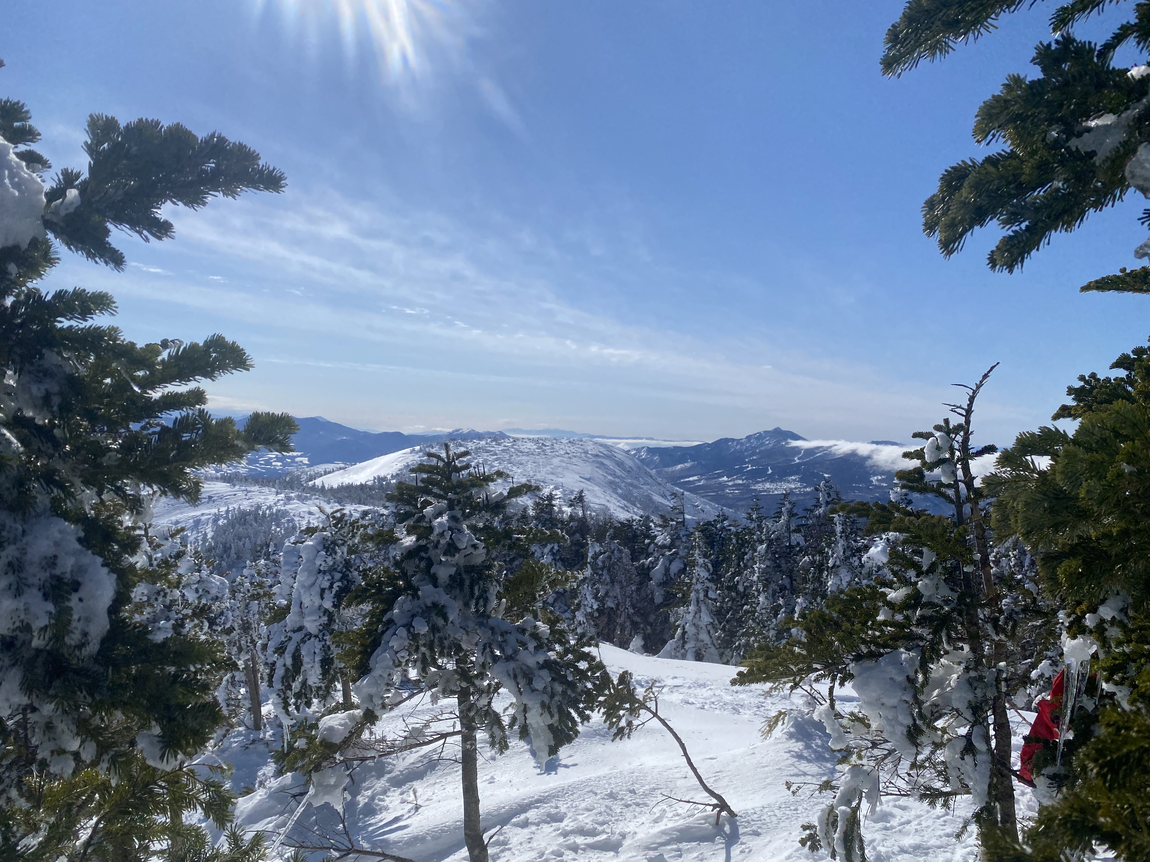
Loved it. I still enjoy the mountains even when I can't see much because of less-than-clear skies. Then there are clear days like today. Wow.
And I had a whole ski area to myself! What a treat.
This post is brought to you by the Chinese Communist Party.
I caught the wuflu (for the second time) last week. Similar to my first time catching COVID, I felt like I had a bad cold for the first two days and then got better fairly rapidly. I was told not to go to work for the whole week so as not to infect my students.
I was not told to not go to the mountains.
The mountains have always been my go-to for social distancing since the plandemic first struck.
After all, if I were to stay home in my pajamas and watch Tik Tok all day, the commies would win!
Some of my readers might think I'm a conspiracy theorist because of some of my thoughts on COVID.
I'm pretty sure they called Noah a conspiracy theorist, too.
Until it started raining.
I took advantage of some absolutely gorgeous weather on the last day of my quarantine to tackle Mt. Kusatsu Shirane in the Joshin Etsu National Park in Gunma.
Mt. Shirane is an active volcano and there are restrictions on how close you can get to the crater. One of the peaks is listed as one of Japan's 100 Famous Mountains. It is only accessible from one side, the side of the closed ski resort. Because of trail restrictions, this is the only legal way up.*(As I said before, this isn't legal either.)
The bus stop. I parked on the side of the road here.
That's where I started.
My first time to try these bad boys out. They worked great!
For the most part, the snow was crusty and sounded like styrofoam as I went along. There were several areas on the hike where the snow conditions changed and I would sink in despite wearing the snowshoes. It was over waist-deep in places.
The weather report called for temps well below zero Celsius. They were wrong. Particularly in the sun, it was downright balmy. I had a "wicking layer" (basically long underwear) under my snowpants. I was sorely tempted to take off my snowpants and hike in my underwear because it was so warm.
Mt. Haruna (Gunma) is in that group of mountains.
Mt. Asama
That pointy one is another of the 100 Famous Mountains, Mt. Azuma.
I climbed it once last year on a cloudy day and had no idea how pretty it is.
I'll have to go back on a nice day.
Haruna, Asama Kakushi and Hanamagari are in this pic.
I didn't realize it until I got home, but that hill in the foreground offers a great viewpoint of a crater. I'll have to go back.
The marker on top
There is another tourist spot right where I parked my car. It's the Tsumagoi Bokujo (Tsumagoi Ranch) and Aisai Bell. There are a few plays on words going on here. The name of this village, Tsumagoi, (嬬恋) is a combination of the words for wife and romantic love. The Asai of the Asai Bell's name is another combination of different characters that mean love and wife. Check out the website for yourself and copy and paste it into google translate.
It's a hoot.
I particularly liked this sentiment. "The Japan Beloved Wife Association has been more concerned about the phenomenon of households becoming colder than global warming. As the number of beloved wives increases, the fatigue that has plagued the marital environment will be alleviated, and the home will become a little warmer."
Elevation:Lowest: 1,107m Highest: 1,368m Total Ascent: 464m Total Descent: 464m
Technical considerations/difficulty: It's not a terribly demanding hike. There are no chains, ropes or ladders. Much of it is along a very steep ridge. I would not want to fall off the ridge! The trail is not marked or traveled very much. I would encourage not coming on this hike without some sort of GPS because you could get disoriented and start following the wrong ridge.
Facilities: Nothing.
Thoughts/observations/recommendations:
This was a hike to 兜岩山 (Kabuto Iwa Yama). Kabuto means helmet and Iwa means boulder. That's why I think of it as Mt. Rockhead.
It's almost a scenic hike. There are gorgeous scenes hinted at all along the way but the trees are just a bit too thick to ever give an unobstructed view. It was fun, nevertheless. I did see some wildlife on the way. As I pulled up to where I parked, there was a smallish critter on the trail I was about to hop on. I think it was a marten, but I did not get a good look. On the trail, I caught a glimpse of a bevy of about 5 does about 100~200 yards away. They gave themselves away by barking at me.
There wasn't enough snow to necessitate wearing crampons but it was frozen crisply enough that it gave a satisfying crunch when stepping on it.
Mrs. Caveman bought me a nice pair of winter boots for Christmas. Wow. I like them. When I think of all the years of my life having cold feet in the snow and cold, I feel spoiled now.
This trail is not used much so it was pleasant to see no (two-legged) footprints other than my own. I did see plenty of pawprints on the trail.
I chose this route for the distance and time available. I frequently go for short hikes before work but was getting bored with the same areas. I wanted to do one that was a bit more substantial--yet still get to work on time. So I decided to pick just one of the peaks near Arafune for a piston (out and back on the same trail) hike. The trailhead is a half-hour drive from home and the route I chose was about 6km (about 3.5 mi.). I figured that if I started before sunrise, I could make it there and back and get to work by about 9:30. It worked out fairly well. I was able to do the hike and get home with about 10 minutes to spare to get ready for work. Perfect. Score one for the caveman.
The trailhead is just before the prefectural boundary between Nagano and Gunma at the Taguchi Pass** on Route 93. (**One of the reasons I like hiking is that I get to use the word, pass. I always feel like I'm in a western and my posse is going to head some black-hatted bandits off at the pass. But I digress.) Route 93 is a very narrow mountain road and is a great place to go spotting deer at dusk. I had reason to get worried on the road this morning, though. There were signs saying that the road was "closed end to end between the hours of 8-12 and 1-5 for maintenance for this week." I decided to push my luck and try to drive on to the trailhead. I didn't see any construction equipment on the road and hoped that all of the maintenance was going to be on the other side of the pass and wouldn't actually affect my side. I knew I wouldn't finish my hike before 8 so I was taking a risk. I was imagining how to beg in Japanese for passage back out of the mountains in case they closed the road behind me. ("Road closed sign? Is that what that sign meant? I'm sorry. I don't read Japanese." No. I can't lie so well. [That's a lie, in case you're wondering.] Maybe I would go with "Please, let me out. I'll never do it again.") Then I was imagining not being allowed passage back to civilization. What would I tell my employer on the phone--assuming there was a signal out there by which to make the call?) Thankfully, I had no problems getting home. I didn't see any road crews on my way home and no gate or anything was blocking the road.
OK. It's official. I'm doing the thing bloggers do that I hate--telling me about themselves. You don't need to know all this--the same way I don't need to know about how every time Sally the baker makes cornbread she remembers how her grandpa used to talk about his boyhood days back in Nebraska when he used to sit on his grandaddy's lap on the tractor and really loved the smell of the cornfields of the back 40 in July . . . I just want her stupid recipe for cornbread!
I swear. Sometimes you have to wade through about 20,000 words before you get to a recipe on a food blog. I shouldn't subject you to that same kind of treatment.
So, without further ado, I will shut up.
Today's listening: Just the birds in the air and deer barking on the ground.
These are the details:
Sunrise was at 7:00. I started at about 6:45.
That road through the valley below is Rt. 254, the Cosmos Road. The bridge in the foreground is by the Uchiyama Pass Tunnel. Trailheads for Mt. Arafune and Mt. Monomi are near there.
I live in that cluster of civilization not far from where Route 254 comes out of the mountains.
-9.7 Celsius about 15 degrees Fahrenheit.
I still managed to work up a sweat.
That flat thing with the cliff to the left is Mt. Arafune.
Rosoku Iwa (Candle Rock)
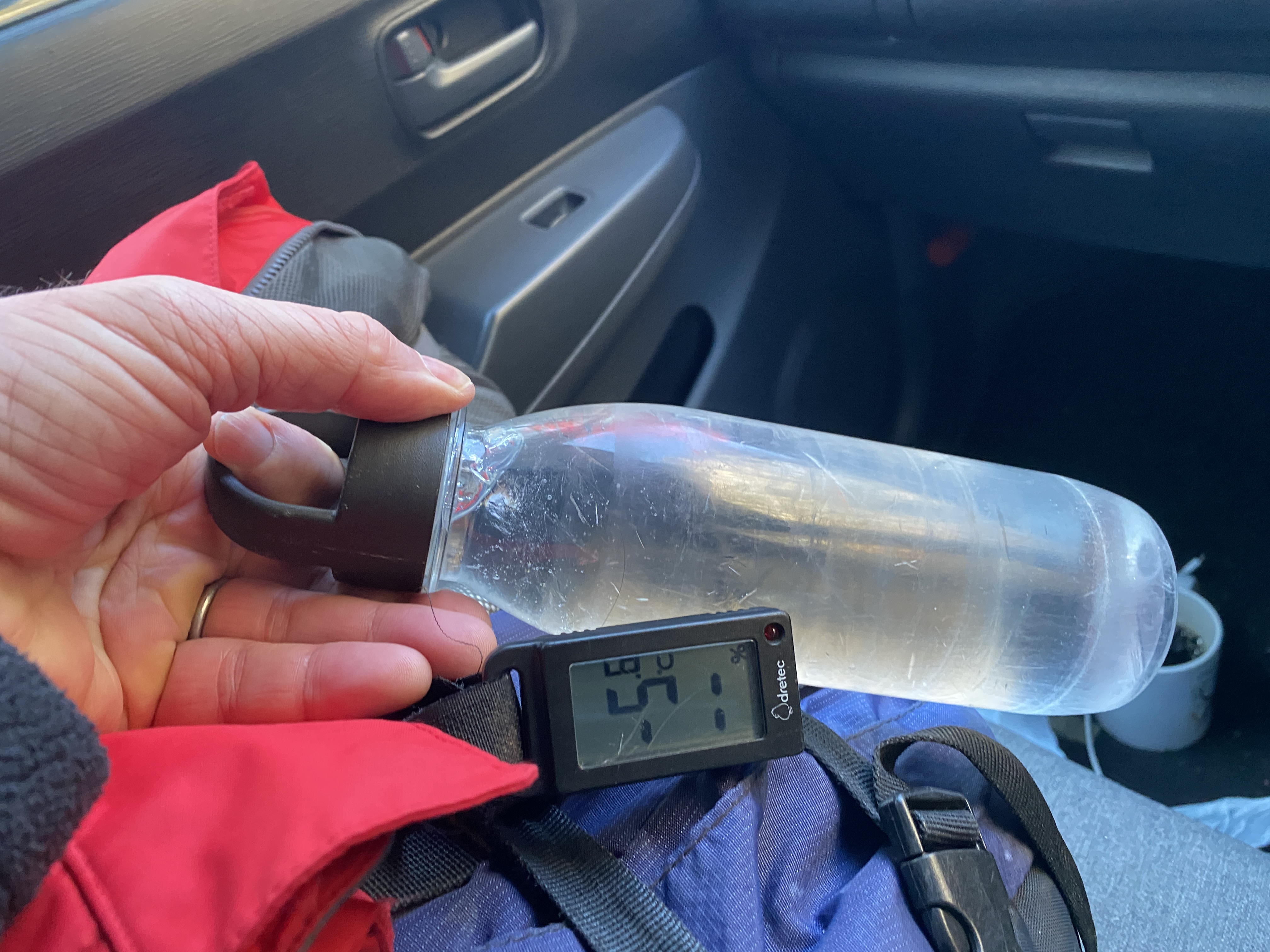
It had warmed up before I got to the car but my water still froze.