Yesterday was my first venture to the area around Lake Motosu and Lake Shoji. Those are the two most western of the Fuji 5 Lakes. I've hiked around most areas of the other three lakes. In my never-ending quest to connect the dots of my hikes, I have a few loose ends to tie up around Kawaguchi and Saiko Lakes and I'm looking forward to spending more time in this particular area.
Yesterday's plan was to climb Ryugatake (Dragon Mountain) and Kenashi (Hairless Mountain) from Lake Motosu. I stopped at Ryugatake because there was just nothing to see. Clouds obscured everything and I decided to call it a day with an eye to returning at a later date so that I could catch the views.
Upon descending to my bike, I decided to ride around the lake and then look into visiting some of the caves or other tourist spots in the area before heading home. By the time I'd ridden around the lake, the weather had broken enough that hiking seemed like an option for the afternoon. I decided to head toward Mt. Omuro--the mountaintop with the nearest unobscured view of Fuji from its west side.
Here's a map of both hikes. Please note that it is oriented with north at the bottom of the picture. I'll put more details about the hikes at the end of the post.
The day started out beautifully. The weather was great on the 3-hour ride from my home.
I reached Lake Motosu around 7:45. It's a nice lake. Each of the 5 lakes has a different vibe.
This lake is absolutely surrounded by campgrounds--in distinction to the other lakes which are surrounded by cafes, hotels or other more upscale tourist attractions.
The lake itself is different, too. There are a lot of SUPs, kayaks and sailboards on Lake Motosu. I really like the atmosphere around this lake. I think camping here would be fun.
For my hike up to Ryugatake, I started at the lake and reached the top in about an hour and a half, if I recall. The weather and visibility were great--until I reached the altitude where I might see something!
I'm sure it would be a spectacular view of Mt. Fuji . . .
The bamboo grass (笹, "sasa") was quite thick. It's not that much of a nuisance but it is concerning that snakes might be hiding in it.
Sometimes it can be dangerous if the sasa is concealing a hole or something to trip over.
This is one of the few times I've ever turned back for a reason other than danger. I got here and felt "What's the use?"
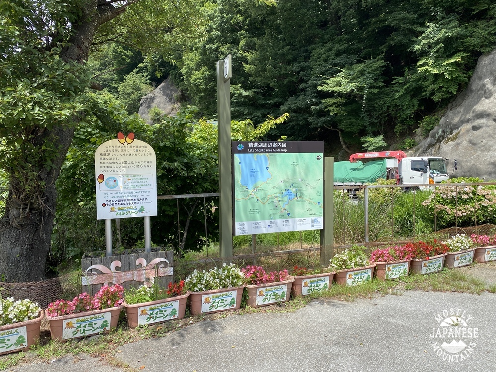
On to Lake Shoji, the starting point for the next trek. This is at the parking lot of the Akaike Restaurant.
This is the actual trailhead. I could have parked here but didn't know where the trailhead was until I hunted around a bit. I didn't realize that this is the starting point for a trail up to Mt. Fuji. This trail meets up with the Yoshida Trail at the 5th Station.
For the first several miles, the trail could accommodate vehicular traffic. Pretty easy walking.
Pictures don't capture how green this area is.
The Aokigahara Forest is famous for an unfortunate reason which I won't go into. I will say this--it's a beautiful, well-maintained forest. I bumped into several happy and healthy groups of hikers and two groups touring the caves.
On the way, I dropped by the Wind Caves. A tourguide gave me the lowdown. Would you believe he told me, your caveman, I couldn't go in because I didn't have permission? I almost said to him, "Do you know who I am?" But, seriously, even the caveman can't go in there without permission and you need a helmet and headlamp.
The south peak of Mt. Omuro. According to YAMAP, this is my 600th peak.
The view from just off the south peak of Mt. Omuro.
I took the next few pictures looking down and this area from Mt. Fuji last August. That dark cone is Fuji's shadow. Isn't that cool? I wonder what effect that shadow might have on property values in that area.
This was taken from the road.
Observations, etc.
Getting there/around: I took my bike. A car or bike makes one of these hikes possible in a (long) day. There are buses from Kawaguchiko Station. Taking the bus would leave only a 6-hour window to be in the area if you go just for one day. It's the blue line that goes to Motosu. Fujikyu Bus Info
Ryugatake hike: 7.2km. 3 hours. 600 meters up, 600 meters down. If I had gone on to Mt. Kenashi, it would have been 16.5km. Not too strenuous.
Omuro hike: 15.4km. 4 hours, 20 minutes. 619 meters up, 619 meters down. Much of it is paved. Don't stop at the first peak. The view is from the second peak. Mt. Omuro is off the path which goes to Fuji. Make sure you are good with a map.
That's it for today! Keep your fingers crossed for good weather. I'm hoping to get out again this week.
Mrs. Caveman knows me better than I know myself. About a week ago she asked me, "Are you going to climb Mt. Fuji this year?" I thought that was a strange question. Another hike up there was the last thing on my mind. Well, here it is just a week later and I am blogging about another hike up Mt. Fuji.
Maybe she just wanted to get me out of the house for a day?
This time, I opted to go up from the south side. We live to the northeast of Fuji so I have always avoided that side because it seemed too inconvenient. The usual routes to get to that part of the mountain from here would entail long, expensive train rides. No thanks. The Caveman is a cheapskate. Well, on a few of my recent trips to mountains on Izu, I passed through Gotemba and realized I could take my scooter to the area around the Fujisan trailheads more cheaply than taking the trains.
I climbed the Fujinomiya Trail from the 5th Station.
Let me get the statistics and details out of the way.
Getting there:
The trailhead is on the Fuji Skyline (Route 152). This is closed to private traffic during the hiking season between July~September 10th and you must go to the trailhead by bus. There are buses from Mishima Station, Shin-Fuji Station or Fujinomiya Station if you are coming by train. If you are coming by car, you can get much closer to the trailhead than one of those stations. Fujikyu Bus Co. is the bus company that runs from the train stations. Even though I can speak and read Japanese, I find their bus schedules notoriously difficult to understand and even hard to find. Using googlemaps to check transportation routes doesn't give you their accurate schedules. Fujikyu's phone number for that area is 0545712495.
Since the Skyline is closed to private traffic, you still need to take a bus for that part of the trip. You can park at Mizugatsuka and catch a shuttle bus from there to the trailhead at the 5th Station's bus stop. (Fujinomiyaguchigogome 富士宮口5合目). That shuttle bus runs from 6 am til 5 pm on the hour. It's about a 30-minute ride. ¥2,000 roundtrip. Parking at the Mizugatsuka Parking Lot is ¥1,000.
This shuttle is run by a different outfit and was really hard to find on the web. If you can read Japanese, this page will help you: http://www.pref.shizuoka.jp/kensetsu/ke-210/fujisan/ Click on 2 よくある質問and a PDF with prices, schedules and departure points for shuttle buses to the traiheads of both the Fujinomiya and the Subashiri Trails will appear. I just checked this link (August, 2023) and it's dead. Rather than put up another specific link that is likely to go dead, I'll suggest you try this search yourself of the Shizuoka Prefecture's page Good luck.
The hard lesson I've learned about public transportation in the mountains is to check, check, check--and then check again. More than once I have had hikes "extended" by miles when I got out of the woods to a bus stop only to find out that the bus I'd planned on riding wasn't running that day. Bus schedules that change with the various natural and holiday seasons are very easy to mistake.
The hike:
I got on the first bus at 6:00 so was on the trail at 6:30. I got to the Fujinomiya Shrine at the top around 9:30 and then walked all the way around the crater and just a little passed the Fujinomiya Shrine where I had lunch on a rock at the top of the Subashiri Trail around 11~11:30. From there, I headed down to Mt. Hoei before bouncing back to the Fujinomiya Trail to get to the bus stop. I was back at the bus stop about 1:45. It was 13.5km. The starting elevation was 2,400m and the top of Fuji is 3,776m. During the hike, I went up 1,652m and down 1,640m.
This was my first time to climb Fuji during the day successfully. Some friends and I were turned back by bad weather on a previous attempt a few years ago. The convenience of a daytrip was nice. Even though it meant leaving home at 3:00 am, it was nice to be home for dinner that night! That is a major pro of doing Fuji this way and from this route. Another pro for me of this plan was the different perspective. Since most of my life I have been looking at Fuji from the northern side, it was neat to look at it from the south. Mt. Hoei and its crater on the south side are cool. Cons of this type of schedule include the loss of the view as the morning progresses. Fuji typically gathers a lot of clouds by about 9 or 10 am at this time of year so the best views of it are while you're still on your way up. By climbing at night and catching the sunrise on top I was able to get long views before the clouds came. When I was on top yesterday, I couldn't see much of anything down below. Another con is the sun. I didn't feel that it was particularly sunny . . . but I got a sunburn. And that is despite wearing a hat and sunscreen.
Clothes. I spent most of the day in shorts and a t-shirt. I did have a fleece with me and a few other items but didn't need the fleece except when I sat down to eat. That is a pro of doing it during the day. At night, it's coooooold and I needed a wool hat and an actual jacket.
I did notice that the type of hikers I encountered on a daytrip tended to be different than on the overnight trips. There were quite a few families with kids and this was, in many cases, a bad idea. Many of the kids were fine. They are like monkeys. They aren't as heavy as adults and seem to be able to climb well. Some other kids, though, were over-tired and miserable. Please, know your own and your kids' abilities before you decide to bring them up there. I saw more than one father carrying two backpacks. I saw some kids just passed out on the trail and parents trying to coax them up to get moving. One mother was carrying a backpack and trying to piggy-back her (rather large) child.
There are lots of websites with information and tips on climbing Mt. Fuji. It's not my intention of being the definitive guide to Mt. Fuji with this post. I just like sharing my pictures and experiences! If you want to ask me any questions, feel free. You can even do that anonymously if you like. None of the comments I receive get published until I look at them so if you want to say something just between you and me, you can do that.
Let's look at some pictures.
On the way up. That black bump is Mt. Hoei.
On either side of the trail were these two posts.
I'd love to know more about this tradition. There is a USMC training center on Mt. Fuji. Do any of you know why these Marines and sailors have put their rank insignia here? For that matter, what is the significance of the Japanese coins?
This is the Mannnen Yuki Hut. (Mannnen Yuki, 万年雪, means something like "perpetual snow.")
There are many of these huts on the mountain. They provide a place for resting, eating, buying souvenirs or emergency necessities and pay toilets. One of the cool things they do is brand your walking stick with their particular sign. Last year, when I climbed Fuji with my son, I cut my walking stick in half and split it with him. I cut my half down even more so that it is very portable and I can take it back to Fuji again and again. The stamp I'm pointing at in the picture was put there at the Mannen Yuki Hut yesterday.
Speaking of perpetual snow . . .
This is the top of the Fujinomiya Trail.
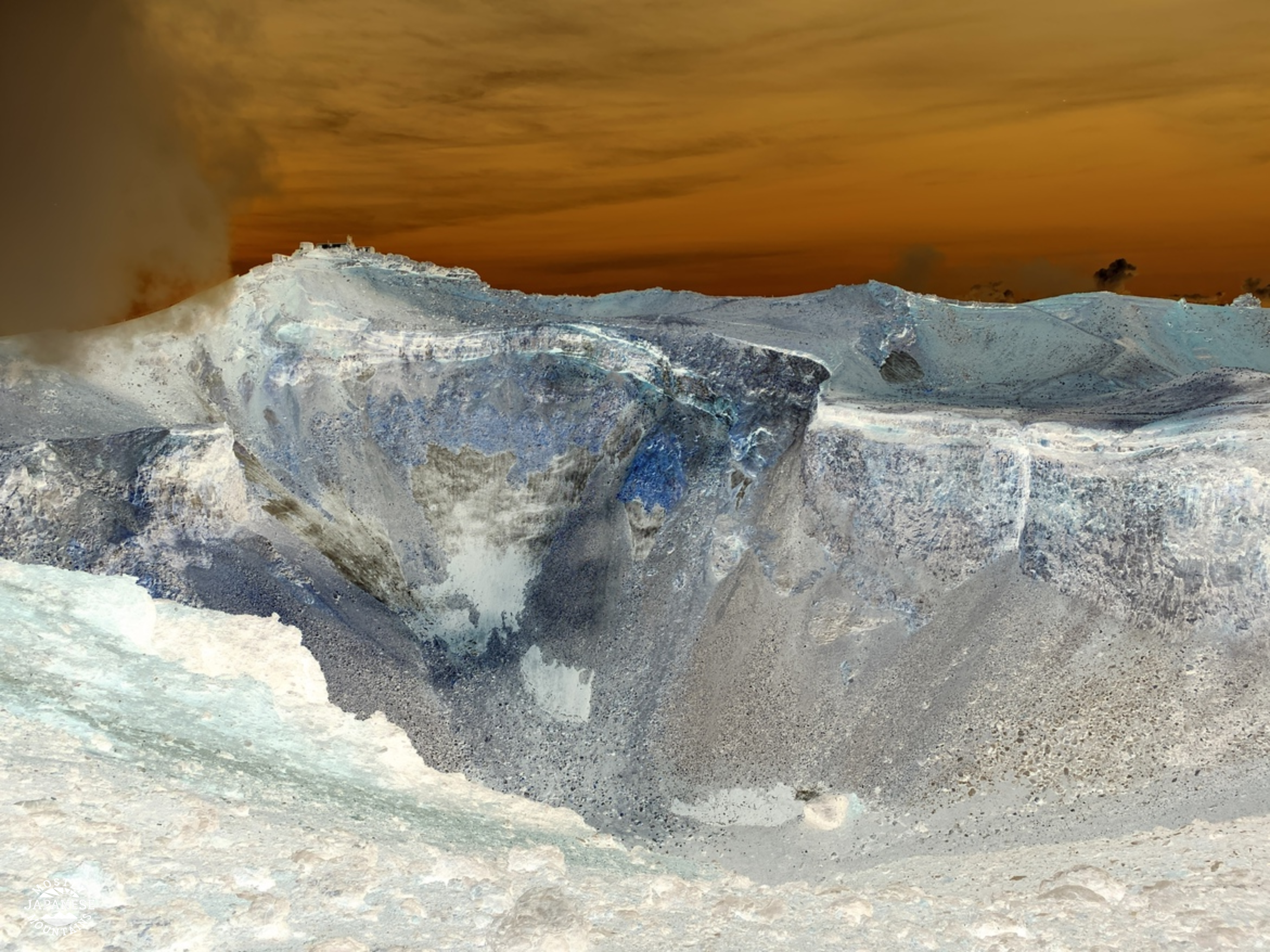
I remember first being on the rim of the crater in the late 90s. It was a cold, windy day. It was so windy that I was afraid to go this close because it felt like I'd be blown inside.
This is the tippy-top. 剣ヶ峰--"Kengamine" is what they call this peak. The component characters are "sword" and "peak" but together they mean crater rim.
My apologies for the ugly face in the pic. I tried to take one just of the monument, too, but there were a million people around.
I wanted to show this picture as a representative of one of the ground surfaces here. These rocks are very light because they are very porous. They make a crunching sound when you walk on them.
This is another type of ground cover you encounter on Fuji. This surface is very black, small rocks. This is easy to walk on. I actually found myself running here. Nearby, these rocks get smaller and it turns into very deep sand. That is hard to walk up. Going down is easy. You can slide/run down it.
This is heading toward Mt. Hoei.
The peak of Mt. Hoei.
The crater by Mount Hoei. I really wish I had some clearer pictures of this for you. It's cool.
Time to head home and dream up the next adventure.
Thanks for dropping by. Thanks to all the new subscribers. Wow.
For a long time, I have been trying to complete the route from my house to Lake Yamanak--and then onto Mt. Fuji beyond. I started trying to ride by bicycle to Fuji a few years ago but was thwarted because the Doshi Road was wiped out in a typhoon. I ended up doing it by hiking the ridge in sections. Finishing the trudge through Doshi Village to the mountains overlooking Lake Yamanaka and facing Mt. Fuji was great!
This was taken on the road in Doshi Village. It was a beautiful day for a ride.
This hike was a strategic culmination of a sort. Lake Yamanaka and Lake Kawaguchi to the west have been targets of mine for the past year or so. On the Kawaguchi/Tsuru-shi side, I've hiked all the trails from Otsuki to the top of Fuji and also to the north of Lake Kawaguchi. Until yesterday, I had made only one foray down to Lake Yamanaka on a trip over Mt. Shakushi. On the eastern side, I've been slogging along the ridgelines to the west of the Doshi River for seemingly an eternity. Yesterday, I finally reached the lake on that side--and I connected up with the spot where I hiked down to the lake before from the west side. In military terms, I executed a pincer movement. 🤣
The bit I did yesterday is traced in red. The pink, orange and white lines are along the Doshi Road. The yellow, blues and green are on the Kawaguchi/Tsuru side.
Let me get the statistics and details out of the way.
Getting there:
I took my scooter and parked it by the (湖北バス停) Kohoku Bus Stop. Obviously, you could get there by bus.
Getting around:
There are bus stops all around the lake. There are also rental bicycles (and rental swan boats.
The hike:
I hiked from the bus stop to Mt. Ohira, Mt. Hirao, and Mt. Ishiwari along with seven other mountains not even worth naming. I went as far as the Yamabushi (山伏) Pass just because that is as far as I had been before when coming from another direction. There is nothing there, so I wouldn't set that as a destination. I hiked 20.3km in about 6.5 hours. It was fairly gentle and it didn't seem that far. The lowest point was 985m and the highest was 1,437m. During the hike I went up 1,275m and down 1,277m.
When I came out of the mountains, I walked along the north shore of the lake for the last 40 minutes or so. That was a nice end to the day.
Facilities:
On the trail, there were benches and the occasional roofed structures at appropriate places. There are no restrooms, waterholes or commercial entities on these trails. Down by the lake, there are cafes, and the like.
Recommendations:
By all means, do this. I would recommend hiking up as far as Ishiwari. That has a great view. I think winter would be a great time to do this when it is clear and you can get a great view of a snow-covered Fuji.
If you like flowers, you might want to take a turn to the west and check out the municipal flower garden. I passed through that on a previous hike. It's pretty enough that a newly-married couple were there having their pictures taken. Yamanako Hananomiyako Park That park is 花の都公園 on the left side in the next picture.
Let's look at some pictures.
This first one is one I took of the area from Mt. Fuji last August.
The trail was quite gentle most of the way. There was a lot of wet grass to go through, though. My feet were soaked after a while.
The Katsuragawa (Japanese Judas Tree River) starts here.
"Lake Yamanaka is the source of the Sagami River! Let's all lend a hand in keeping it beautiful."
Fun fact: You can collect swan feathers along the shore of the lake. That was what I brought home to Mrs. Caveman.
I found a legit swimming hole! I have been looking for one on the Doshi River forever! It's deep enough to really swim in.
Subscribe to the blog and I'll tell you where it is. It will be our secret.
I was the only person there for a few minutes until a young couple drove up. I could relate to the guy, he was as excited as a little boy. 😁 He stripped down to his underwear and went in the water.
His girlfriend wasn't having as much fun, though. She stayed covered from head to toe against the sun and didn't go in the water. (I don't think this bodes well for their future.)
I wanted to cheer her up, so I gave her a few of the swan feathers I'd collected. I should have given them to the guy. She seemed determined to say no to fun. 🙅
Like I said, subscribe to the blog if you want to know where the swimming hole is.
I average a little better than a post a week, so do subscribe so you know when the next one is posted. I have a trip to Fuji and a trip to the Northern Alps on the calendar so don't miss those posts.
That's all for now. Take care. Drop by the cave again real soon.