Post #101 Kintokisan, Gorgeous day in the Fuji Hakone Izu National Park

 Greetings cave dwellers.  Thank you for dropping by again.  Pull up a rock.  Make yourself a smore.


Astute readers (ie, me and probably nobody else) will recall that my last post was a "Part 1" and therefore probably expected this to be a "Part 2".    Well, if you did, you were wrong.  

This is a blog about mountains so the occasional cliffhanger is to be expected.  Just hang on.

I will get back to Doshi Village someday.  Don't worry, I am not a serial killer.

Yesterday morning I was heading to the same area I went to last week to continue my adventures around the Doshi Village but changed my mind on the way.  My hike in Doshi Village doesn't promise very much in the way of beautiful views and I really want to do it just to say that I have done it.  There's nothing wrong with that.  A so-so day on any mountain is better than any day just about anywhere else.  Yesterday's weather was just so special, though.  It was a short window of clear blue skies opened up between long periods of rain and clouds or haze.  The majestic glimpse of Mt. Fuji I caught as I was going through Doshi Village made me abruptly adjust my plans.   I decided to take a trip to Mt. Kintoki in Hakone for a hike that has been on my bucket list.  


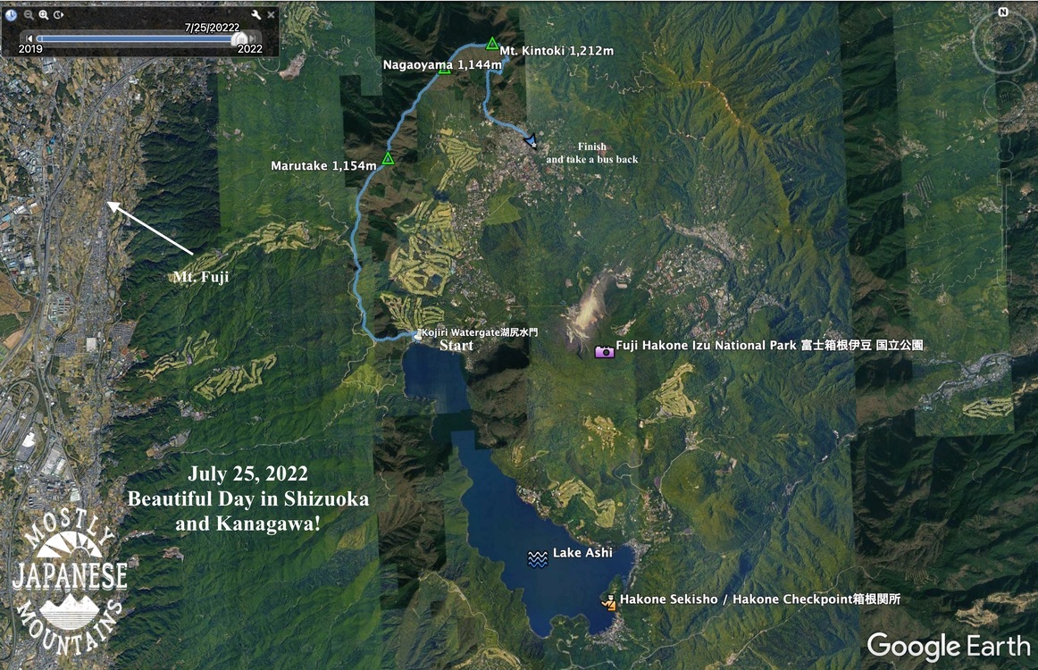
I don't know where I heard of Mt. Kintoki, but it ended up on my bucketlist somehow or other.  I have been to the other side of Ashinoko (Lake Ashi) many years ago to visit the historically significant tourist attraction of the Hakone Checkpoint.  I vaguely recall taking a boat ride, too.  I intend to get back there someday.

Lake Ashi is quite a resort area.  All of Izu is.  There are several ropeways up to the mountains.  It's a golfer's paradise.  There are numerous resorts and onsens.  There are great views, of the lake, of the Sagami and Sugura Bays and, of course, of Mt. Fuji.

Here are the details of the hike.  This is just a hike I came up with on a whim one day.  There are trails all around the lake and if you don't want to go to the particular area I did, I am sure you can find something suiting your desires.  Getting around the area is easier than I had expected.  There are bus stops everywhere.


Getting there:  In my case, I took my scooter.  That made it easier for me to get to the north side of the lake.  It was about 110km from my home.  It took about 3 hours of driving.  If going by public transportation, most people go to Hakone Yumoto Station to the northeast of the Checkpoint first (a little over an hour by shinkansen from Tokyo Station) and then take buses to where they want to go.  The Hakone Checkpoint is 52 minutes by bus from there.  The time and the train and bus changes are the reasons I haven't been there in so long.  As the crow flies, it's not far.  As the trains and buses run (or even cars), it's a hassle.

Getting around there: is surprisingly easy.  There are bus stops everywhere.  Just be aware that there are many different bus companies and you need to pay attention to exactly which bus stop and bus it is you need. 

The hike:  
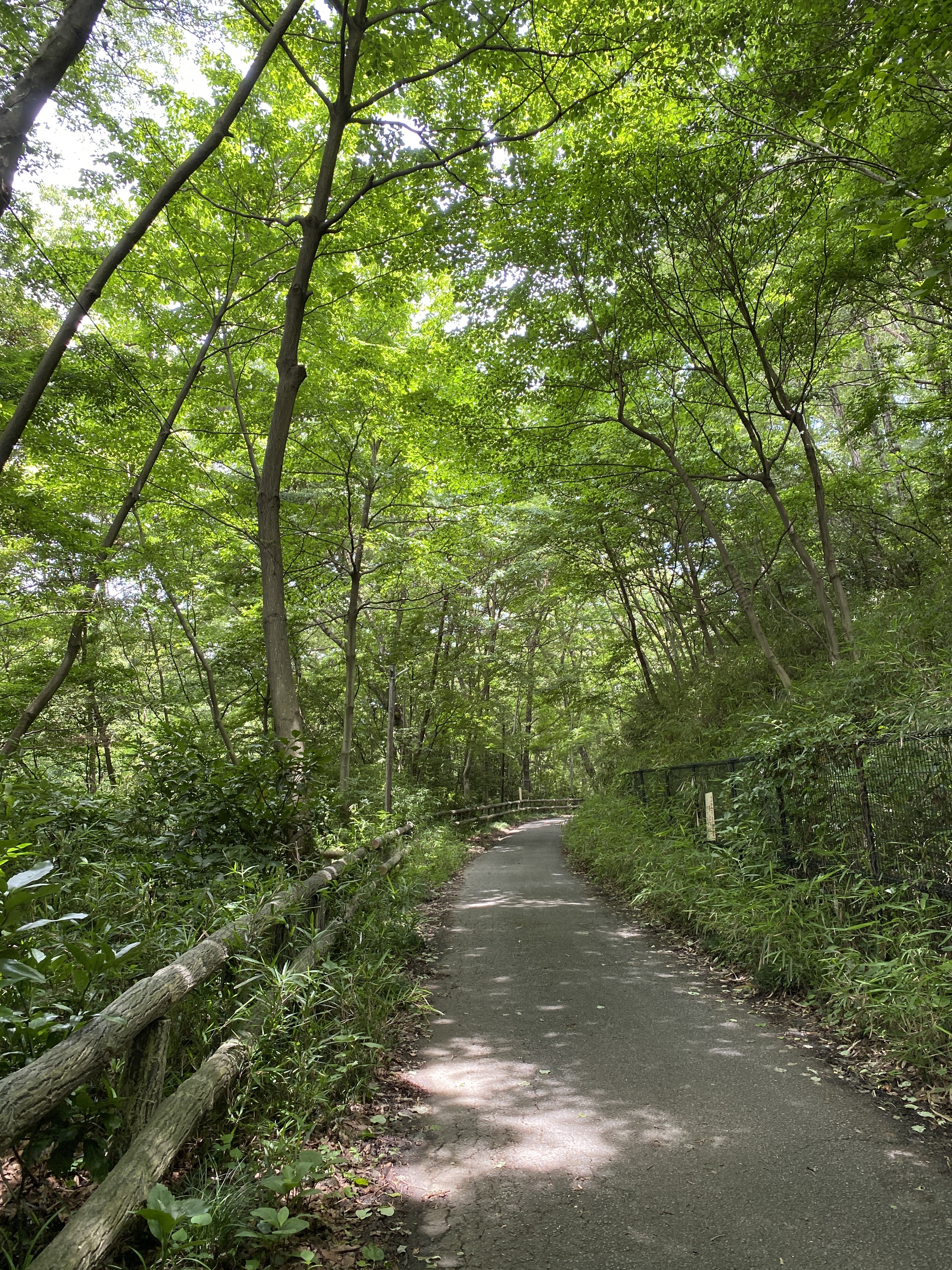
I like water, so I decided to start at the lake.  Starting this far away enabled me to hit a few peaks on the way to Mt. Kintoki.  It was about 12.5km and had an elevation change of something like 970 meters up and 1,070 meters down.  The trail, for the most part, was very gentle.  There were almost no chains or ladders.  Anyone could do it.  I think the word for the day was pleasant.  There were several places along the way accessible by car that could shorten the trip.  I exited the mountain at the Kintoki trailhead.  As you can see, that was quite close to the top.  I did this in just under 5 hours.  I don't run, but I'm faster than most.

Facilities:  No water on the trail until the top of Mt. Kintoki.  There were free public restrooms along the way.  At the top of Kinotoki, there is a paid restroom.  Also, there are two little mountain huts at the top.  They had plenty of food and mountain swag.

Let's look at some pictures.

Most people probably have no idea that you might hear loud noises coming from Mt. Fuji.  I took these videos from Lake Yamanaka on my way yesterday.  The bangs are from USMC howitzers at Camp Fuji.  They were firing a lot yesterday.  Made me nostalgic for my days with my 11C platoon.


Motorboat prices (up to 5 people)
Once around the lake ¥10,000
Special Course ¥8,000
Halfway ¥6,500
Pedalboat (3 people) 30 minutes
swanboat ¥1,500
Rowboat 30 minutes
2 people¥1,000
3 people ¥1,200
"We also have fishing boats and motorboats available."


I stuck my hand in the water here.  I was surprised how warm it was.  
The lake is very clean.


I was able to pick out this watergate from the mountains.  I couldn't believe how far away it seemed.


This is near the beginning of the trail.  Much of it was like this.  Not too drastic a slope and surrounded by vegetation.  

The cicadas, of course, were loud.  The birds were chirping away.  The atmosphere reminded of the Allman's song, "Blue Sky".  It was not only picture perfect, but song perfect.


That sandy, smokey area to the left of center is the Owakudani Valley.  It is traversed by a ropeway.


Here's a view of the watergate


It's the season for mountain lillies.


The top of Kintoki.


I'll put this up in case you want any explanation of the background of the name of the mountain.  I'm sure this will clear things up so much no more explanation will be necessary.  


Maybe this will help.


You may be seeing this picture and assuming it's really delicious.  Actually, it's not.  It's my failed attempt at making calzone.  It was so bad that I kept the leftovers until I could eat them in the mountains.  Since everything tastes better in the mountains I figured I could stomach it here if I could not eat it at home.


Kintaro hard candy*.  There is a story behind this.  

*How they make it is kind of interesting.  Look for a video on youtube if you want to know how.


If I climb one of the 100 Famous Mountains, or if I go to an exceptionally cool mountain, I might buy some swag.  Not often, though.  I'm a cheapskate.  

I liked the ax on this mountain so I broke open my wallet and bought this 手拭い ("tenugui", ie, handcloth) from the Kintaro Chaya on the top of the mountain.  Tenugui are very light, cotton cloths and are super useful for hiking.  I always have two or three when I am hiking.    


The proprietor of the Kintaro Chaya was a really sweet obaasan (old lady).  When I bought the tenugui, she presented me with that Kintaro candy and some other sweets.  She even split a popsicle-type thing in half and gave half to me and half to another customer.

I was so struck by just how nice she was that 5 minutes down the trail I decided to go back and buy a t-shirt.  For plunking my dough down for the t-shirt, I was rewarded with another popsicle.  This time a whole one just to myself!


The Kintoki Yadori Stone.  Kintaro was born here.


That's all for now.  I am dying to get out there again.  I have a lot of time off and more places on the bucketlist . . . but it's raining.  There is rain in the forecast for something like the next 10 days.  Keep your fingers crossed for another window like yesterday.

Take care.


Doshi Mura July 2022, part 1

Howdy doody, cave dwellers.  Welcome back to my place.  

Yesterday I went for my first hike in what seems like years.  Actually, it's been less than 3 weeks since my last real hike, but I was itching to get out.  Yesterday was the first day of my summer vacation so I wasn't going to let the opportunity go.  On a whim, I chose to head down to the Doshi Mura (Doshi Village) area of Yamanashi to connect some lines on my map.  Yesterday's destination had less to do with seeing a special vista or challenging peak as it was just about putting on some miles.

One room in our house is my cave away from my mancave.  It's the map room.  The better part of three walls of it is covered with maps on which I trace where I have hiked or biked.  The pictures below are of one part of the maps that have not been marked up as much as other parts.  

The maps in the picture are of the Doshi Village in Yamanashi.  The Doshi River runs southwest to northeast from Doshi Village up to Sagami in Kanagawa.  To its southwest is Lake Yamanaka and beyond that is Mt. Fuji.  Doshi Village has the distinction of having the highest density of campgrounds in Japan.  Doshi Michi (Michi means street or road.) was the scene for most of the bicycle road race in the 2020 Olympics.  Doshi is a lovely area but it is kind of hard to get to and the Doshi Michi is the only way in or out.  2 or 3 times I have tried to ride my bicycle from my home to Lake Yamanaka but was turned back each time because of road closures.  The 2019 typhoon made the road impassable for a long time.  The Olympians may have been delayed by COVID, but at least the roads were open when they did come.  

But I digress . . . 

Anyway, I like to connect the dots on my hiking excursions.  It's kind of like thru-hiking by stages.  I want to mark up those blank spots on the map.  The area I decided to concentrate on now is marked by the oval.


This marks what I did yesterday.  I'm planning to go back tomorrow and mark up some more of the offensive blank spots.  

I take my inspiration from Maria von T.  "Climb every mountain" 🎡🎡

This is what it looked like on google earth.  


Speaking of google earth, there's a new place I heard about the other day in Delaware.  It's called Brandon Falls.  Look it up on google earth or googlemaps.

The animation

The details:

Getting there:  This time I parked my scooter near the Ooguri Bus Stop (ε€§ζ —γƒγ‚Ήεœ) and hiked from there. 

There are ample bus stops along the Doshi Michi but the buses all depart from the southwest.  Like I said, it's not so easy to get to the area.  This is why there are still so many blank areas on my maps of this area!

If you want to get there by public transportation from Shinjuku, you have to go way around it to the north and turn south at Otsuki passing to the west of Doshi Mura toward Kawaguchiko.  THEN you can take a bus to head northeast to Doshi.  The shortest time to do this is 3 hours and 46 minutes.  Most options take 4.5~5.5 hours.  My home to where I was yesterday is 37km as the crow flies.  Were I to take public transportation, it would be a trip of 103km.  

The trail:  On this trip, I hiked about 17 km (a little over 10 miles) in about 6.5 hours.  There are several trails up to the ridge so you could shorten or lengthen this hike to your tastes.  It's not that high, I don't think there was any point over 1,300 meters.  There isn't anything extreme or scary.  There are no ladders or chains.  I didn't even need gloves.  Although most of this was a ridgeline hike, I was surprised at how much change in elevation I experienced.  The trail undulated so much that I ended up rising and falling about 1,600 meters.  (That is about a mile for any Americans reading this.)  That is a fair amount of change in elevation.  My ankles did feel a bit rubbery by the end.

If you're interested in the area, but not in hiking every part of it, I suggest going a bit farther to the south to Mt. Mishotai.  That has a great view as it is closer to Fuji.

Facilities:  Nothing.  No water.  No public toilets on the trail.  Plenty of onsens in the area.  There are many campgrounds but no restaurants.  No convenience stores.  Make sure you have gas, too, if you're driving.  There is one gas station but I think it was closed.


The hike:

One of the best things about this hike is that I didn't see anyone.  Not one soul.  I love that.  I was a fan of social distancing before it became cool.  Unfortunately, since the trail isn't used that much, it doesn't get any maintenance.  They were many spots like this that were overgrown with grass and ferns.


Critters.  

There were a lot of bugs on this trip.  So much so, that I didn't stop for anything.  I ate and drank on the move because the bugs were ubiquitous.  

If anything is going to kill me in the mountains, it will probably be a frog or a snake.  Not from their venom; I'll just be scared to death.  Frogs and snakes always give me a start and I'm afraid they'll make me jump off a cliff.


I don't know what kind of snake this is.  Perhaps a baby mamushi.  The markings don't seem right, though.  Do any of you know?


Fuji appeared at just 2 or 3 spots on the trail.


Looking east toward the Tanzawa Range.  The biggest mountain in the picture is Mt. Omuro, if I recall.


Not very photogenic, but pleasant.  Much of the trail was like this.


I pondered these splintered signs for a while.  Was it a sasquatch?  Did Yogi throw a temper tantrum?


Exiting the mountain into the neighborhood I was treated by the fruits of the labor of the locals' green thumbs.


Bucolic.


Cubolic


Oh, yeah.  That's the ticket.  My dogs were yelping after that day.


Come back again soon.  
Take care of yourself and those you love.

Don't be afraid to press the "support me" button.  πŸ™  I'm hoping to hit one or two of the big boys next month and would appreciate some help to defray costs.  I'm told mountain rescue 🚁 is prohibitively expensive here.  🀣


Mountain biking in the Sayama Nature Park


This post is dedicated to Michael B., a legend of mountain biking.  He left us too soon.

Welcome to the mancave.  I trust you are beating the heat this summer.

I decided to drop by a cooler part of the man-cave today since the heat of July is upon us.  It has been quite a while since I ventured up to the Sayama Hills and Tama Lake area and since today was a better day for a bike ride than a hike, I headed up there.

The Sayama Nature Park is a sprawling wooded area surrounding two large lakes divided between two prefectures and spreading across several cities and towns.  

The two lakes, Sayama Lake to the west in Saitama, and Tama Lake to the east in Tokyo are both drinking water reservoirs.  Both lakes offer great views of the mountains to the north, west, and south.  

Since they are sources of drinking water, there is no boating, swimming, or fishing.  The area surrounding the lake does have plenty of opportunities for leisure.  As I already said, there are LOTS of hiking and biking trails.  The trail surfaces range from rocky and bumpy mountain trails to smooth, level hiking paths to paved dedicated bicycle paths to paved roads for car traffic.  Along with those pathways, there are numerous picnic spots, restaurants, onsens, and love hotels.  (Rest ¥4,000!  Stay ¥8,000.  You can imagine.)  The Seibu Lions (pro baseball) play at the Belunna Dome and kids of all ages can play at the Seibu Yuenchi (Amusement Park).  There are too many shrines and temples to count.


I can get to the general area from home in about a half-hour.  To take a trip around both lakes is about 20 km.  You could cut the trip more than in half by circumventing only one of the lakes.  There are also too-many-to-count minor trails you can detour on.  As a matter of fact, I should tell you that a GPS is a good thing to have here because it's easy to get twisted around.


Japan cracks me up.  There is so much random cuteness.  This is the last house before entering the park.

Starting out.  This is one type of road surface.


I actually got off my bike and did some "climbing" today.


I made it to the "top" of this 145-meter-tall "mountain."  I try to climb at least one mountain a week.  I guess this counts.


Tama Lake below with the Belluna/Seibu Dome in the distance.  That dome is a great landmark from the mountains.  It is visible for a long way.

The domed structures in the foreground are water intake towers.  They are where the drinking water pipelines begin.


The Ferris Wheel at Seibu Yuenchi from Tama Lake


Getting to the area between the two lakes now.  This is the dome up close.  I think there actually was a game going on.


Now starting around Sayama Lake.  The road surface on this side of the park is much rougher.  I wouldn't do it if I weren't on a mountain bike.


"Takane Ridge Road" in the "Rokudoyama Park"


I really should have taken a more representative picture of the road through this area.  It's quite rocky and bumpy for a few miles.  (ie, it's fun!)

This place is Rokudoyama (六道山) Observatory at Rokudoyama Park.  There is a water fountain, a public restroom, and picnic tables in the park.  You can climb to the top of the observatory for a great panorama.  It wasn't clear enough to bother climbing up it today so I'll post some pics I took on a past trip.


March, 2021


Speaking of pictures I didn't take today . . . On a past trip, I stumbled on this spot which has a fantastic view of the runway at Yokota Air Base and I was able to watch C-130s landing and taking off.  I had my binoculars with me that day, so it was really cool.  The exact spot is here:

I live under the flight path of Yokota but have never had such a good view as I had that day.