Post-COVID saw tourism explode in Japan. Last year saw record numbers of climbers of Mt. Fuji which caused lots of problems. Public restrooms were overwhelmed. Too many people left trash on the mountain. Injuries of unprepared climbers strained the patience and the resources of the local authorities and service industry.
Despite new restrictions put in replace in response to the situation, this year's hiking season started off tragically. This video doesn't mention it, but 5 people died within just the first week or so of the climbing season.
Fuji shouldn't cost you your life. Just be prepared. And be ready to skip it or turn around in case of inclement weather.
I was lucky to be living in fairly close proximity to Fuji during COVID. I had the mountain almost all to myself some days.
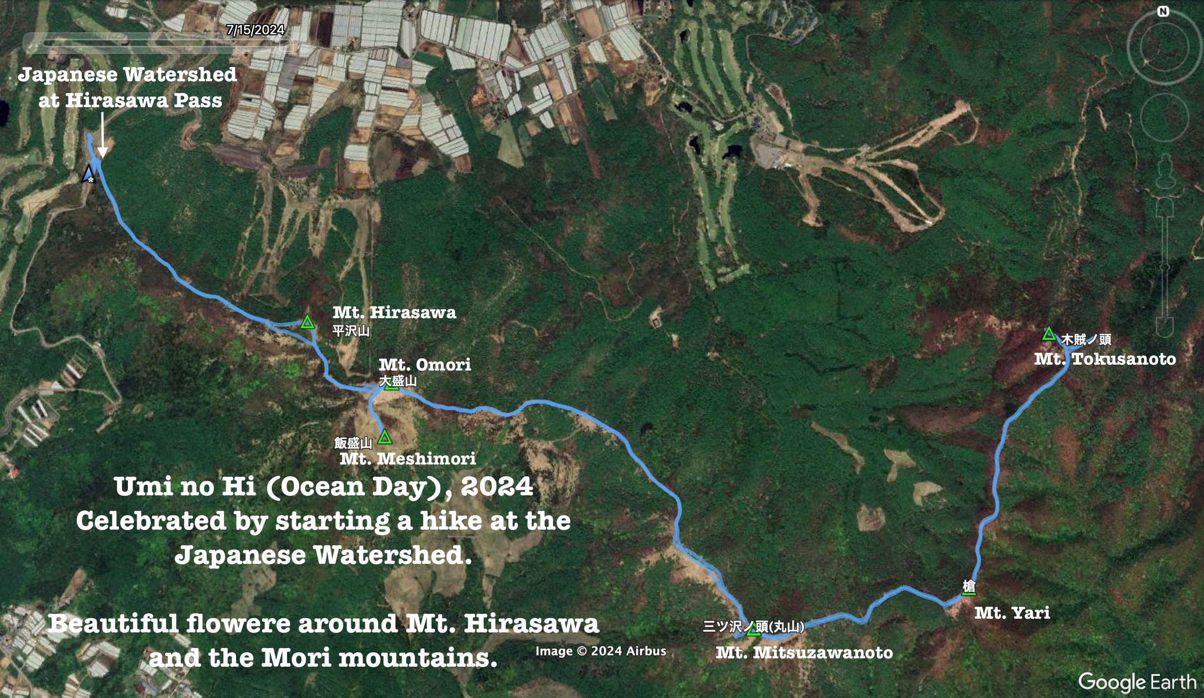
This report is about a hike around Minamimaki Mura (Nagano) and Hokuto Shi (Yamanashi).
Area:
Location: Nearest station is Kiyosato on the Koumi Line.
Map: ***The Caveman is giving up on posting links to Yamatokogen maps. They go out of date and the links die. If you want one of those maps, comment and I'll get you a current link.
This is a printable topographical map. It doesn't contain as much information as the Yamatokogen map. Interactive Map in English日本語
Peaks bagged: Hirasawa (平沢) ~ Omori (大盛り) ~ Meshimori (飯盛) ~ Mitsuzawanoto (三ツ沢ノ頭) ~ Yari (槍) ~ Tokusanoto (木賊ノ頭)
(First-time) peaks # 902~907
Getting there/getting around:There are several parking lots near the various trailheads. There are buses from Nobeyama Station to the parkin lot I used.
Lowest: 1,442 Highest: 1,780m Total Ascent: 1,151 Total Descent: 1,155
Technical considerations/difficulty:
The beginning of this hike, the part of this hike that most people would actually like to do, is very easy. Most people go only a few km from the trailhead and poke around the beautiful flowers and take in the panoramic views from Mt. Hirasawa, Mt. Omori and Mt. Meshimori. Those trails are very well maintained and easy to pass along. The ridgeline can be followed past Mt. Omori over several other mountains to the Shinshu Pass (and even further, if you like!)
Beyond Mt. Omori, the number of hikers drastically decreases, as does the quality of the trail and the quality of the views. I went several km beyond Omori just past Tokusanoto. It wasn't raining but I still got soaked from the waist down because of the bamboo grass. Most of the trail is covered with it and there are also many deadfalls along the way. There is only one place with a chain but for the most part the biggest danger is from slipping downhill in the mud. If you do choose to keep going beyond Mt. Omori, beware that the trail is often not marked. You need to be able to sniff out which way to go. A GPS device is definitely recommended.
All of this hike is below the treeline. The low elevation worked out well on this particular day in rainy season. Most of the higher mountains were covered in clouds and, I assume, in rain.
Facilities:
Public restroom at the parking lot. Vending machines for drinks also. Nothing on the trail.
Thoughts/observations/recommendations:
Yet one more place I want to go back to on a really clear day! Winter must offer great views of Yatsugatake, the Minami Alps and Mt. Fuji.
The flowers really are spectacular. Different ones bloom throughout the spring and summer so this place would be worth visiting at different times.
Here are some pictures . . .
I don't know flower names. Thankfully, they have signs.
This is Shishi Boulder. It's right next to the parking lot
From aforementioned rock
Bus schedule
Trailhead
Entering the flower zone.
The first peak of the day
Mt. Mizugaki. Kinpusan is hiding to its right.
From Mitsuzawasan
It was a bit of a slog getting through the bamboo grass ("sasa") on the back end of the day's hike.
Heading back
The problem with all these flowers is the temptation they offer every 2 or 3 steps to stop and take a picture.
Despite all the strife and difficulty in the world, God did leave us with a lot of beauty.