Quick, before the floods come! Bunbori and Shiroyama. Low hills in Tokyo.
I have today and tomorrow off. I was hoping to go for a long hike during this time, maybe even an overnight trip.
Since the weather people have been forecasting rain for the past few days, though, I decided to curtail my plans and try to fit in a quick hike this morning before the deluge. I only hiked about 3.5 miles.
I was successful. I've been to the mountains and back and it hasn't started raining yet. I've been home for 4 hours and nary a drop has fallen.
I feel like I got gypped. They told me quite authoritatively (100% chance!) that it would start raining at 2 pm.
I'm starting to trust the meteorologists about the next few hours' weather about as much as I trust Prince Charles or Greta Thunberg about what the climate will be in a century or a decade.
All they say is blah, blah blah.
Anyway, I'll share what I did today. It may give someone an idea for a light excursion. Today does show that you don't need to overtax yourself in order to experience some of nature's beauty in Tokyo.
Today, I took my scooter to the Nishi Kura Bus Stop on Route 33. You can reach there by bus from Musashi Itsukaichi Station. Normally I would take my bicycle since it's only about 12 miles from home but I was afraid I'd be caught in a downpour. For those familiar with this road, it's a mile or two past the Kurochaya (黒茶屋.)
Anyway, I poked around the trails between the Nishi Kura and the Jurigi bus stops. I hiked to two little "mountains" and took a peek at few shrines.
It is true that you don't have to go far to get some cool views. Since these foothills are higher than anything to their east, you can see really far. I couldn't pick it up in a picture, but even as overcast as it was today, I could see Tokyo Skytree with the naked eye. That's on the other side of Tokyo. I also got some great views of USAF C-130s flying over Yokota Air Base. For opsec purposes, I won't post any pictures here. ;-)
This is from Shiroyama.
This is an artist's rendition, and an historian's imagining of what this area used to be. This mountain's name, Shiro, means castle. They believe it was a castle and that samurai used it in the past. They're not quite sure who or when, though.
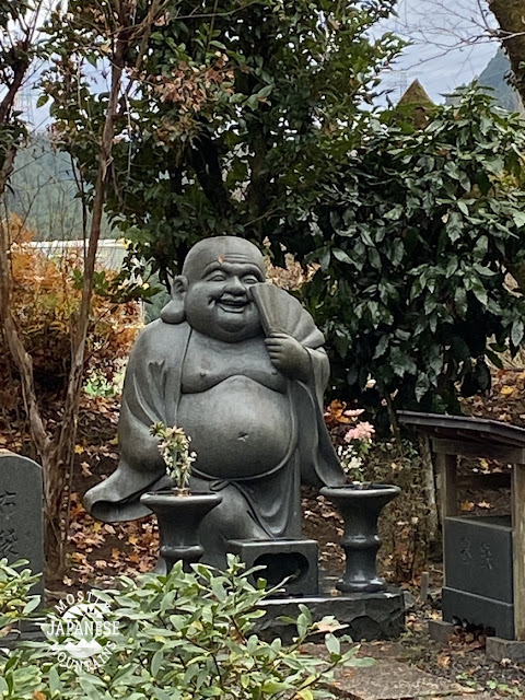
This guy is at a temple (Kogonji) I passed through. There are a few temples and shrines in the area and several small cemeteries.
This big cherry tree is at the same temple. It's called Oosakura in Japanese. That means "Big Cherry Tree" in English. I'll bet you didn't see that coming.
It must be something to see in the spring.
https://goo.gl/maps/X2NveGdaKXZbYdL28
One thing that I find interesting is that the Japanese soil is so fertile that the growing season never seems to end. It's not uncommon to see root crops growing under a cover of snow.
One last pic of the trail...
That's all for today. I had thought of going to a nearby onsen today since I had such a short hike and would have more time available than usual. I skipped it though. I didn't work up enough of a sweat to justify it.
If you are interested in an onsen in this area, the nearest one is the Seoto no Yu. Nice place. http://www.seotonoyu.jp/


No comments:
Post a Comment
Have a comment? Please, keep it clean.