Starting and stopping points: Bicycle from Saku City to Ogawahara Pass. Hiking started and finished there.
Peaks bagged: Maekake 前掛山 Tateshina 蓼科山 Futago 双子山
Getting there/getting around: I used my bicycle to get to the trailhead via the Tateshina Skyline. That road is still closed to cars due to snow. I think it opens in mid-June. Many people come to Tateshina from the western side where there is a gondola nearby.
Map: Yama to Kogen Chizu 33 YATSUGA-TAKE TATESHINA・UTSUKUSHIGAHARA・KIRIGAMINE 八ヶ岳蓼科・美ヶ原・霧ヶ峰
**Please note that the publisher makes updated maps every year and therefore this link might become obsolete. If you copy and paste the Japanese characters into Shobunsha's Mapple Siteyou should be able to find the latest version.
Technical considerations/difficulty: It's not a terrifically difficult hike. Alltrails says that is moderately challenging. I guess so. The most taxing part of my day was the bike ride to the trailhead. That was 25 km riding uphill. On the hike, there are not many areas with chains or ropes. There is still quite a bit of snow on the trail. I probably should have brought my crampons. I myself am not a fan of walking poles but I saw many people putting theirs to good use descending down the snowy trail. Much of the hike is above the tree line and the ground surface is boulders or rocks. Some of the rocks are loose and you really have to watch your footing.
Facilities: There is parking and a public restroom at the pass but they aren't open for the season yet. There are a few huts (hutte) on the way. You can get a meal or some hiking stuff on the way. There is a campground by the Futago Ponds (双子池).
Thoughts/observations/recommendations: Wow. What a great start to Golden Week for 2023. I really enjoyed this trip.
I think I want to come back here in the winter some year. There is such a great 360 degree panorama. All the Alps are visible, as well as other prominent mountains. I really would like to see that on a crystal clear day.
Here are some pictures:
The bike rides
The hike
I live in Saku City, Nagano. I can see 3 of the 100 Famous Mountains from home; one of them is Mt. Tateshina. For my first assault on Tateshina, I decided to take my bicycle to the trailhead on the Tateshina Skyline. During Golden Week, there is a hot air balloon festival here in Saku and I was treated to views of the balloons from the moment I stepped out of my house.
Very cool!
The Tateshina Skyline is a really beautiful mountain road. I didn't see more than a handful of cars. There are a few farms along the way and many cottages/summer homes.
It is a loooong, unrelenting uphill slope, though. On flat ground, this ride would take me about 90 minutes. This took me nearly four hours.
This was ominous. It says "road closed ahead." I didn't see anything about road closures in my research! I decided to press on and just see what would happen.
The truth is out there.
What is this place, the Japanese Area 51?
No, it's nothing like that. That dish is a deep-space research facility called JAXA. JAXA
The road was open to cars just to there. Beyond that, they haven't opened up the Tateshina Skyline because all the snow hasn't melted yet. (99% of it has. I was fine on the bicycle.)
By the time I reached the deserted parking lot at the Ogawahara Pass, my legs were like rubber. I seriously questioned whether I could hike after that. Actually, the hike was almost less taxing.
There was more snow on the trail than I'd anticipated.
This was my first glimpse of Tateshina from the trail.
This is the Ogawahara Hut (大河原ヒュッテ). Several trails intersect here and the trail from here to the top got a bit crowded. Until this point I had only seen one or two people.
This hut (and the facility at Futago Ike) is linked here.
The top
I live in that valley.
I am a big fan of pictures like this. I just learned that there is a Japanese word, "komorebi" that means "sunlight filtering through lush, thick leaves." I love komorebi.
There are two small ponds side by side which are called 双子池 (Futago Ike)--that means Twin Ponds. There are campsites by the lake and a hut nearby. Futago ike mountain cabin 双子池ヒュッテ
The smaller of the two ponds.
Did I mention that I like komorebi?
I took this shot of Tateshina from Mt. Futago just before descending down to my bicycle.
From there, it was all downhill. Quite literally. According to my app, I burned 931 calories on the bike ride home. I doubt that very much. Gravity did all the work.
I'm in a hotel tonight that has a big screen TV. I realized I can watch youtube on it and ended up watching movies I've posted of the mountains. Wow. I have never seen them on a screen larger than my laptop. If you can watch my movies on a large screen I highly recommend it!
Lowest: 1,345m Highest: 1,828m Total Ascent: 1,129m Total Descent: 1,129m
Technical considerations/difficulty:
This hike was not particularly scary or taxing. There are very few ropes or chains. The only really steep section is the slope direct between the lake and the peak of Mt. Akagi. That section is kind of interesting as it is characterized by fairly large boulders shaded by trees. Unfortunately, being the shortest route to the top, it is also characterized by a lot of people. I came down that way and thought that it must be a bit taxing going the other way. One other factor that affected the day was the wind. The temperature wasn't really cold but the wind was quite high and I was glad that I had a Goretex shell to wear over a fleece.
Facilities:
There are several restaurants and the like around the lake. There are also boats on the lake. Most of the businesses weren't open yet as Golden Week is still approaching.
Thoughts/observations/recommendations:
I can't say I didn't enjoy it. I did. That said, I almost wonder why this is one of the 100 Famous Mountains. Most of them that I have completed so far have been really, really special. This one was just really special.
After finishing the larger portion of the trip, I decided to go back and check out one more hilltop that I'd skipped in the morning. This is Mt. Kita. There is a sign on top but there is no trail to get there.
I'm not going to give a blow-by-blow account. If you're interested in going to the area, you'll discover for yourself the ins and outs of it. I'll just put up a bunch of pictures for your perusal.
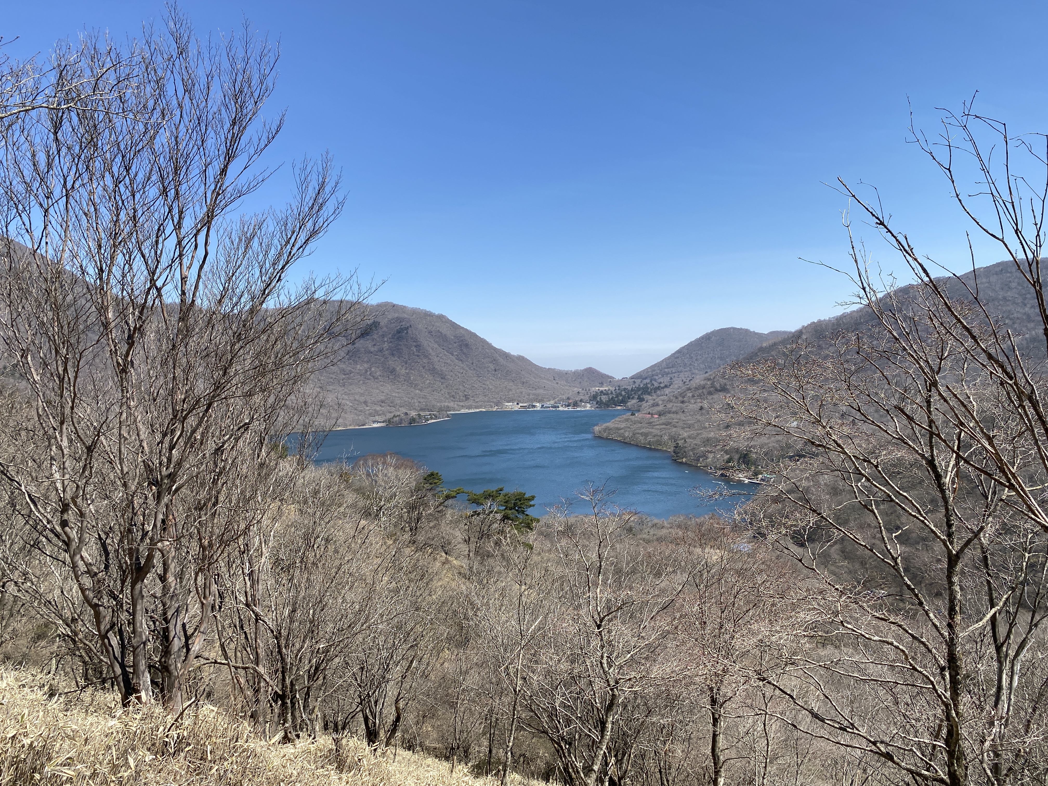
The first stop of the day was Konuma. That means small marsh.
I climbed the second mountain from the left last week. The one to its right, Mt. Tateshina, is another of the 100 Famous Mountains as is Mt. Asama in the middle. Those are both visible from my house and I am itching to try them out.
I wrote before that I wonder why Mt. Akagi is one of the 100 Famous Mountains. On second thought, I can now see that the views from here on a clear day would really warrant putting Mt. Akagi on the list. There really is a lot in line of sight from this area.
Mrs. Caveman is visiting her family in the cave of her youth in the tropical paradise she hails from right now. Where she is, there is a heat wave and a heat index of around 50 degrees Celsius! I'll take the ice and snow here, thank you.
This is Kakumanbuchi (Kakuman Marshland) in the foreground and Lake Onuma beyond that.
Looking back on Konuma.
It's nice . . . but it would be even better if Mt. Fuji wasn't hiding behind the haze.
Some spots on these trails reminded me of hobbits.
Many Japanese hikers often put a lot of effort into eating gourmet food on the trails. They'll carry stoves with them and cook some really elaborate dishes and have a glass of wine on a mountaintop. That's not my style. I don't want to carry anything extra and I don't want to spend time cooking. If I want something hot, I just bring a thermos.
This day's "gourmet" lunch was ham and prosciutto on homemade bread. Yum.
After lunch on top, I came down to the water level before going back up into the mountains to swing around the west side of the lake.
The Akagi Shrine with the mountain above
These guys are well-fed and have really good rhythm.
I have to say that the carp up here can be really huge.
They are also eaten around where I live.
Mt. Akagi
This is Mt. Kita.
After I came off the mountain, I drove down a very long, narrow, windy road to this campground to spend the night. It was a nice place.
Home for the night.
Inside the campground
Maebashi City from the campground
This is the next day. I had business to attend to in Takasaki. That is a nice city.
The ruins of Takasaki Castle
I took this on the way home. I think one of those mountains is Mt. Myougi. That one is going on my bucket list, too.
That's all for today. If you read this far, thanks.
Remember to subscribe, comment and tell your friends about the crazy guy with the groovy mancave.
Want to see another of the 100 Famous Mountains? Kobushi