Do you like that keychain? That little keychain cost me more than the ¥500 I plunked down for it yesterday.
Astute readers of this blog will recall that a few days ago, on New Year's Day, I lost my bike 🏍 keys 🎹 on Mt. Oyama. Yesterday saw the conclusion of that saga.
This keychain is the replacement for the one I lost. I bought it yesterday on Mt. Oyama.
To review for you slow students that weren't paying attention and those of you that were smoking butts 🚬 in the 3rd-floor boys room 🚽, or getting yelled at in the principal's office, I climbed Oyama for sunrise 🌅 on January 1. It was gorgeous. The only black mark on the day was that I seem to have dropped my keys somewhere on the mountain. When I got back to my bike, they were nowhere to be found.
I called the police👮. I visited places I'd been on the mountain. I even climbed to the top again looking but to no avail.
I took the train home that day and left my bike at the parking lot.
Two days later, when businesses here start to open up again after New Year's, I got a bike shop in the area to take care of the situation for me. He picked up the bike and brought it to a 🔒smith to have a new key made. Yesterday, I went down to get it.
Since I was in the area, of course I had to do some more hiking while I was there. It was a lose-win situation!
So this little keychain* cost me about 15 extra miles hiking, the cost of towing my bike, having a key made and train fare back and forth between home and Kanagawa twice.
Speaking of the train ride to Kanagawa, this trip again reinforced my gratitude at usually being able to take my scooter to the mountains instead of relying on trains. I left home at 5 am yesterday and should have been at the trailhead by 7. I should have been there by 7 but there was a 人身事故--an "accident with personal injury"--which is often a euphemism for suicide. That meant an extra hour in detouring by changing to other train lines to go around the stoppage. Adding to my stress of lost time and frustration at having to navigate unfamiliar train lines, I felt guilty about being angry at someone who'd probably just killed himself.
RIP, if it was a suicide. And my condolences to the family. What a sad thing it must be for those left behind.
I'll be really mad if I ever lose this keychain.😆
At least this happened while I'm still on vacation. It was really not the end of the world. I'm happy to have an excuse a reason to go to the mountains.
*The keychain is actually a miniature omikuji--an eight-sided cylinder-type box containing fortunes written on sticks. You shake the box and one of the sticks falls out. On the stick is written your luck--whether it be bad, fair or good. I really, really don't go in for any kind of fortune-telling, but this keychain is the only one they sold on the mountain that was a good size for me. Also, it has the name of Mt. Oyama on it so it seemed an appropriate memento.
Mountains climbed: 浅間山(Sengen, The first of 2!) ~ 権現山(Gongen) ~ 弘法山(Koubou) ~ 善波山/奈古木浅間山(Zenba/NagokiSengen) ~ 念仏山(Nenbutsu) ~ 谷戸の頭(Yatonoatama) ~ 高取山(Takatori) ~ 浅間山(Sengen, the second or third of the day!)
Getting there/getting around: I chose to hike right from Hadano Station on the Odakyu Line. There are buses from there to the area. One popular route is to go from there to the Yabitsu Pass/ヤビツ峠 from which Mt. Oyama to its east or the other mountains of the Tanzawa Range to its west can be accessed. (There is parking near that bus stop and I've been there on my scooter before.) I exited the mountains at the Minoge Bus Stop and kept walking along the road the two-odd miles to my destination. There happened to be a bus going my way just about to depart that bus stop when I got there but I didn't get on because one, I'm cheap and two, I like walking.
Elevation: Lowest: 74m Highest: 843m Total Ascent: 1,240m Total Descent: 1,188m
Technical considerations/difficulty: This was not a terribly difficult hike. Passing through the Koboyama Park is quite pleasant. Except for a steep approach at the beginning, that is mostly flat. It's very suited to the flocks of birdwatchers and cherry-blossom viewers it attracts. After that, there are some steep parts but really no chains or ladders to speak of. It's not exposed at all.
Facilities: The Koboyama Park has many water fountains, public toilets and vending machines. In different seasons, there are vendors selling festival-type foods. The Afuri Shrine has a public restroom and (seasonal) restaurants/souvenir shops. There is a public restroom at the Minoge Bus Stop
Thoughts/observations/recommendations: The Koboyama Park is a nice place to do some hanami (cherry blossom viewing in the spring.) There are some really great views of Mt. Fuji, Sagami Bay and you can even see Skytree in Tokyo. I had tentatively planned to hike from Hadano Station all the way to the top of Oyama and then come down via the Yabitsu Pass on Route 70. I gave up on that plan because of time considerations and descended from near the Afuri Shrine. The morning's train accident and my afternoon appointment at the bike shop constrained my time.
Here's what the map of the day looks like. Note that it is not oriented north to south.
The entrance to the Koboyama Park
Viewpoint on Mt. Gongen.
Great view from up there.
From Mt. Gongen
Lots of warnings about leeches around here.
Complimentary salt to repel/detach them.
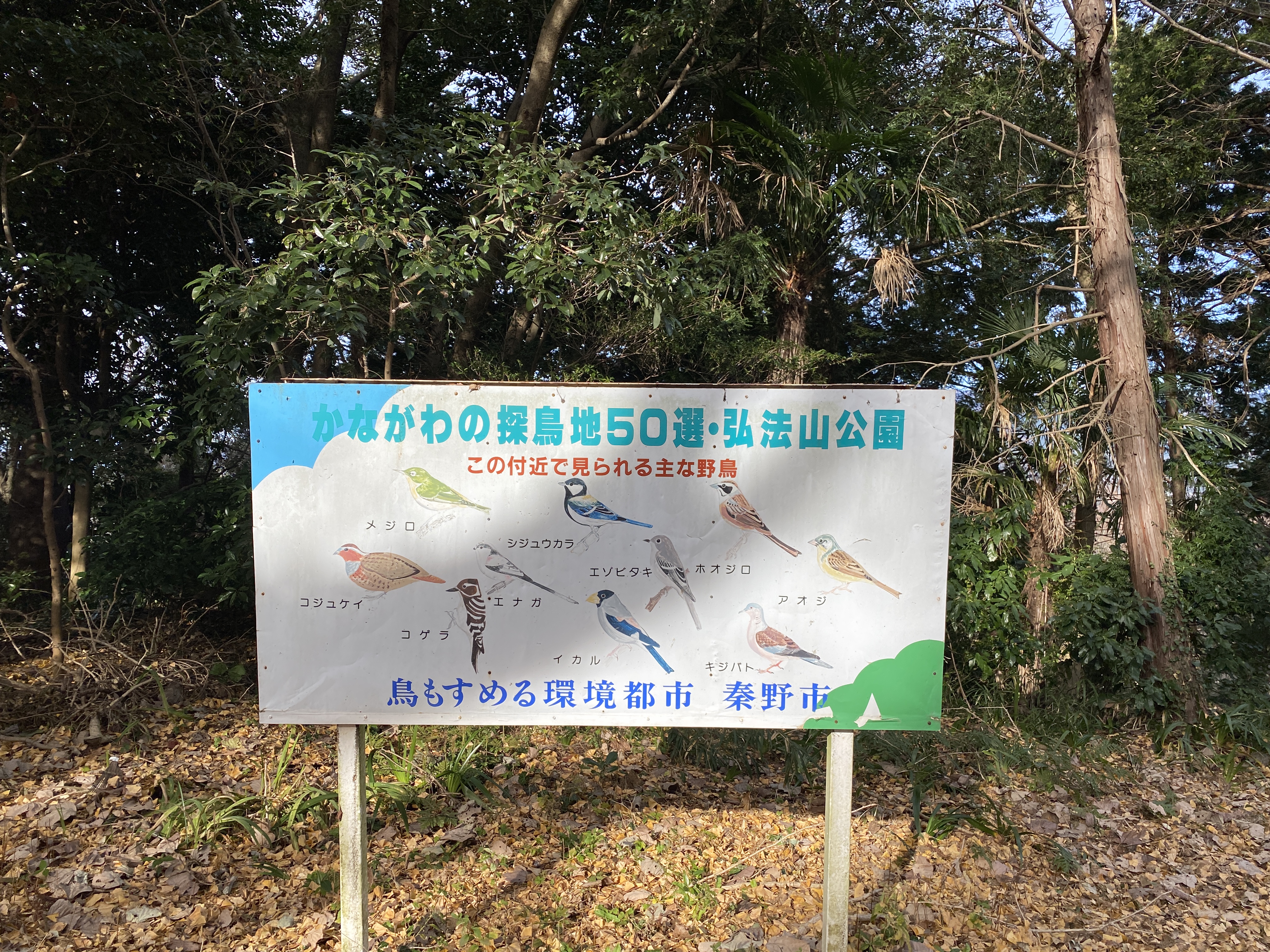
This park is touted as one of the best birding spots in Kanagawa.
From the Afuri Shrine
At the shrine
Getting close to the bus stop.
I think this is the Kaname River.
It's near the Minoge Masu (Trout) Fishing Center
This is across the street from the Minoge Bus Stop
Minoge Bus Stop
Japan must have the best scarecrows in the world.
Well, that's all for today. I still have a few more days off before school starts. I hope to get out again.
Take care of yourselves. Don't forget to subscribe to stay updated.
Greetings cave dwellers. Welcome back to my mancave for another year.
Have you decided on any resolutions? I'm thinking of taking up hiking myself.
The first hike of 2023 ended up being a two-fer for me! I climbed Mt. Oyama twice. I was up to the top of Mt. Oyama and back down to my bike by 9 and ready to go home when I realized my keys were missing. Yikes. Nowhere to be found. Although I climbed the mountain again (bonus hike!) in my search for them, they never appeared.
Here are the details for both hikes. I'll add commentary after that.
Getting there/getting around: There is bus service from Isehara Station on the Odakyu Line. Public transportation doesn't run early enough for sunrise, though. There are many parking lots along Route 611. A shuttle bus runs up and down between the parking lots and Koma Sando.
Elevation: (First time) Lowest: 254m Highest: 1,252m Total Ascent: 1,110m Total Descent: 1,110m (Second time) Lowest: 659m Highest: 1,252m Total Ascent: 718m Total Descent: 729m
Technical considerations/difficulty: The trails here are rugged but extremely well-maintained and sturdy. There are a lot of steep natural rock stairs but very few loose rocks. Dirt parts of the trail that are prone to turning to mud are often traversed with wooden walkways. It offers a good climbing workout without any danger. There are only one or two spots that have chains. Oyama is climbed by people of all ages. I even saw a few parents with newborns strapped to their chests yesterday. If you're out of shape, you can take the cable car to shave a half hour or so of climbing off. If you're really out of shape, you can just take the cable car to the shrine and stop there. There are lots of restaurants and a great view there.
Facilities: Since Mt. Oyama is so popular, there are myriads of souvenir shops and restaurants. Many of these shops line Route 611 where the parking lots are. Route 611 is connected to the cable car station by a quaint shopping street called Koma Sando. Koma Sando has a large concentration of restaurants and gift shops and many little "chokubai" spots selling mountain vegetables, roots and citrus fruits. "Chokubai" means direct selling. Most commonly it means un-manned stands selling produce on the side of the street. Koma is the word for spinning top and this is the place to buy a top if you're into that kind of thing. Evidently, the wood in the area is famous and that's why they make tops here. Just below Afurijinja (Afuri Shrine), near the top of the cable car, there are a few restaurants selling Japanese food, ice cream and hot dogs. T-shirts, etc. are on sale there. At the top of Mt. Oyama, there is another mountain restaurant serving things like ramen and oden. There are public restrooms on the top--but they seem to be closed on weekdays now.
Thoughts/observations/recommendations: First, don't ever lose the 🔑 to your 🛵 on a 🏔. 😭
Yesterday was a great day to welcome the first sunrise of the year and Mt. Oyama is a swell place to do this. No wonder it's popular for the first sunrise. If you go for sunrise on January 1 though, be early. I was really surprised at how all of the parking lots were already full when I got there around 4:30. It took me 15 minutes to find a parking lot with a space for me. I was able to park only because I was on a bike. I don't think there was any car parking left. Indeed, there were cars waiting in the street for people to leave the parking lots all day to open up spaces.
Here are what my hikes looked like yesterday.
First time up. I went basically clockwise.
Second time up
Here's how the day went from the beginning.
1km up the street from the parking lot I got to Koma Sando.
I didn't take this in the morning. The caveman is a cheapskate and also feels that ropeways, gondolas and cablecars are cheating.
Just beyond the cable car, there is a fork in the trail. The 女の道 (Woman's Trail) goes to the left and the 男の道 (Men's Trail) goes to the right. They meet up again later.
I made great time on both of my hikes today. I usually do go a little faster than the estimates on maps because those are based on how long it would take an average group of four 40-y.o. women to hike. Despite all the voices in my head, none of them are 40 and none of them are women, so those estimates never apply to me.
One factor that always increases my speed is the number other people who are on the trail. It always makes me go faster when I encounter someone. It becomes a race and I won't be happy until they are eating my dust. I guess I drive the same way. Anyway, in the early morning, it was like a traffic jam or a line at Disney with everyone heading up for sunrise so I never slowed down from passing speed. On my second trip up, I moved fast just because I was hoping to find my keys before it got too late.
"90 minutes". Ha! I sneer at their estimate. 🐌 I did it in 43. 🏃
After catching the sunrise from the east side of the peak, I headed over to the west side to catch another iconic Japanese view; Mt. Fuji.
And back to the east side for a picture of Tokyo before heading down.
Some place names make me laugh.
When I came down, I used the Women's Trail. It passes this temple.
Can you spot the lost article in the picture? (Hint: it's right in front of your eye.)
Satoji Shrine by the Suzu River
It was soon after this that I got to my scooter and realized I lost my keys. Then I turned around and headed back up the mountain. I stopped into every store I'd been to, I called the cops and I talked to everyone coming down the trail. I even took the cable car 🚠 on the second trip. Buying a ticket was the only way I could get inside to ask about their lost and found.
Last week I was on Mt. Furo which is in line between this point and Mt. Fuji. Despite knowing this, I still can't quite put my finger on which Mountain it is in this picture.
Looking northwest to other mountains in the Tanzawa Range.
I had planned to be home for lunch. No such luck.
That's all for this report from the man cave. I hope