

. . . about Mt. Kurohime
This is a stratovolcano in northern Nagano, very close to Niigata. It is one of the 200 Famous Mountains of Japan and one of the 100 Famous Mountains of Shinshu (Nagano). Kurohime (黒姫) means "Black Princess." There is some legend about where that name comes from but I can't really puzzle it out too well. Check out wikipedia if you're interested.
I do like the name.
Kurohime is a pretty mountain and there are several places you can see it well from. Good viewing spots are Lake Nojiri, the highway and the Shinano Michinoeki.
Area:
Kurohime is surrounded by some other beautiful and famous natural features. Nearby is Lake Nojiri, where you can visit an archaeological museum which catalogues the prehistory of the history and includes fossils of ancient elephants. There are 4 of Japan's 100 Famous Mountains nearby, (Myoko, Hiuchi, Amakazari and Takatsuma).
It is in the Myoko-Togakushi Renzan National Park.
Location:
Map: ***If you want a link to the latest Yama to Kogen map, comment and I'll get you a link. This link is to a printable topo map
Starting and stopping point: Kurohimeyama Oohashi Forest Road Parking Lot
Peaks bagged: Kurohimeyama (黒姫山)
(First-time) peaks # 1,029
Getting there/getting around:
I drove. Parking is free.
There is Alpico Bus Service from Nagano Station to the Togakushi Campground. That would add a bit of distance to your hike, but it would be possible. That takes about an hour and costs ¥2,000.
You could also hike directly from Kurohime Station. That is on the eastern side of the mountain. Going up and back from there is about an 18 km hike, with the first (and last) several kilometers being on pavement through a town.
Helpful Info
Weather Information:
Time and distance
YAMAP's estimate: 7:50 to hike 14.8 km
Actual Time: 6:57 Break time: 1:07 Distance: 16.8 km
Elevation: Lowest: 1,138 m Highest: 2,053 m Total Ascent: 1,067 m Total Descent: 1,067 m
Technical considerations/difficulty:
This is a fairly straightforward hike. My clockwise loop, which took me past the Taneike (Seed Pond) and the Furuike (Old Pond), was quite pleasant and easy. There were no ropes, chains or ladders. The trail was line by sasa (bamboo grass) on both sides but it had been cut back so the trail was quite wide.
My descent was more tedious. That trail is called the 西ー??? (Nishi-something-or-other). Nishi means west. Anyway, that side was slower going and categorized by really large boulders crammed into a narrow trail. You need to scramble over the boulders quite and bit and watch your step lest you fall into a crevace.
That said, it still wasn't dangerous or really difficult. Just tedious and slow.
It was only on that western side that I saw any snow. There were two or three piles in deep holes that never get any sun.
What to bring: (This list is not exhaustive. This is just what I recommend really not forgetting on top of all the regular stuff like maps, headlamps, raingear, etc.)
- Water. I brought more than 4 liters this day and drank it all as it was a hot July day. There are a few streams on these trails--and I usually don't hesitate to drink directly from streams and rivers here--but I am glad I had brought water. I just felt that I wouldn't want to drink from the stream on this mountain.
Facilities:
Nothing
Thoughts/observations/recommendations:
By all means, do this mountain. It's beautiful from below and I'm sure the view from the top is great on a clear day.
There are also several other attractions and mountains in the area. The Togakushi Campground is great to stay at and is a great base for hiking here, on Mt. Takatsuma or Togakushi. Not far from there is the Togakushi Shrine and a Ninja House! Lake Nojiri is beautiful. A cruise around the lake costs ¥1,400 for adults and is really nice. The lake is dotted with restaurants and cafes. Thanks to the shrinking Japanese population (😩), they aren't too crowded.
If you forego the highway in favor of backroads, you'll be amazed at the number of chokubaijo as well as orchards and vineyards where you can enjoy fruit-picking in season.
If you can, go on a clear day. The mountains are always better than an office or factory, but I do wish I hadn't been robbed of a view, yet again!
This is the map

This is the animation
Let's get to some pictures:
I'm sorry to say, but there aren't a lot of pictures with this hike. Unfortunately, the weather didn't cooperate and I wasn't able to see much.
To be honest, I'm not batting 1,000 when it comes to getting nice views in this area. I have climbed 4 or 5 mountains in this park and have had clear weather on only one or 2 days! The picture I used for the title of this post is old. I took that a year or two ago. I didn't see Mt. Kurohime that well on the day of this hike and saw almost nothing from the top. That's just how it is. You can't control the weather. It does make the picture-perfect days all that more special when they come, though.
These first two pictures were taken from Mt. Myoko last year. There should be a great view of Myoko from this area, but it was obscured by clouds on the day I hiked Kurohime.
In that picture, you can see Mt. Hiuchi on the right. I recall the day I climbed that mountain. That was another day of seeing nothing!


Back to the day of this hike, now.
Before heading off to hike, I deposited Mrs. Caveman and her bicycle by Lake Nojiri. She wanted to pedal while I wanted to hike.
How about the size of those carp? Mrs. Caveman was afraid one of them could swallow her whole!


If you're ever in the area, be sure to check out the Naumann Elephant Museum. It's right next to the lake.
It is about a 20-minute drive from Lake Nojiri to the trailhead.

Japan has so many flowers. It is one of the most wonderful features of Japan.
I may not have seen many vistas on this day but I certainly saw flowers.


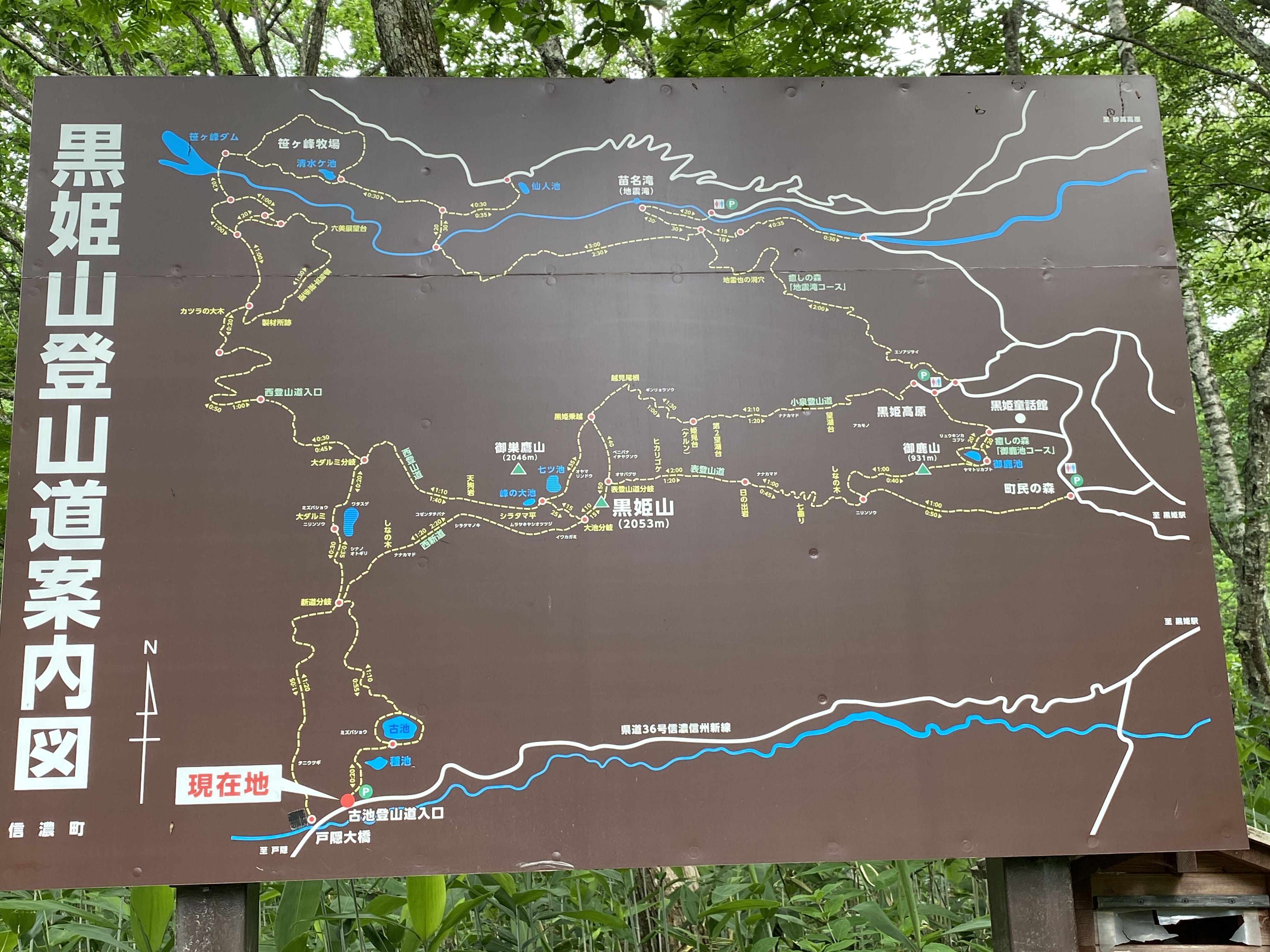
I parked a few minutes' walk from this trailhead. My car is parked at the little red dot on the bottom left corner of the sign. That's where I finished the hike but my trail initially started at the red dot where it says 現在地 ("You are here.") on the map.
種池 Taneike--"Seed-Pond"

古池 Furuike "Old Pond"

It took me three tries to conquer Mt. Takatsuma. Twice, Mrs. Caveman and I stayed at a campground below it with a plan to summit. Once I got rained out, and the second time I got ill overnight and didn't hike.
I eventually went back and did it on a day trip.


This is an extreme close-up. These flowers are much smaller than they appear.


These are really small, too. The blossoms are maybe 1~2 cm across.

I wish it was clearer. Those mountains are really beautiful.


The top is 2,053 meters
For a reference to mountains near my hometown,
Mt. Washington in NH is 1,917 meters.


Turning around and heading down.

This place is called 七つ池 Nanatsuike--"7 Ponds"
On the map, there is water here but I didn't see any on the ground.
This is actually the caldera.

These little white flowers started appearing.

This pond is called 大ダルミ (Odarumi).


Coming down this trail was a bit more demanding than the wide, sasa-lined trail I'd hiked up. There were quite a few deep crevices on the steep hike down. And, even some snow!

I think this one wins for flower of the day.


The nearest onsen was just a little too far away.
Besides, this was more refreshing.

That's all for today.
Make sure you check out the youtube channel and tell your friends about the Caveman.
I won't bite if you leave a comment. Promise.
If you want to see some more of the area, check out
or
Caveman out


.JPG)


