1,000

. . . about Mt. Gohyaku and the environs
Mt. Gohyaku is not actually the main attraction for this area. This area is known as the East Mountains of Nagaoka City. Gohyaku is kind of like the ugly little sister to nearby Mt. Nokogiri. That is a very popular mountain with nice views. You can see the Sea of Japan to the west and snow-capped mountains to the east. Nokogiri (鋸) means sawtooth in Japanese. It's a popular name for mountains. This hike also took in Mt. Onikura (鬼倉), which means "Demon warehouse." That mountain has little to recommend itself for.
Being near the Sea of Japan, this area gets a tremendous amount of snow and most of the forestry roads are still covered with snow now (early May). There is still snow on the mountains, but most of the trails are void of the white stuff and the mountain flowers are springing up while the snow is still melting.
I picked this mountain just for its name. I'll write much about that later in the post. For now, I will get the details of this particular hike out of the way.
Area:
Location:
Map: ***If you want a link to the latest Yama to Kogen map, comment and I'll get you a link. This link is to a printable topo map.
Starting and stopping point: Mt. Nokogiri Parking Lot
Peaks bagged: Nokogiri (鋸山) ~ Onikura (鬼倉山) ~ Gohyaku (五百山)
(First-time) peaks # 1,017~1,019
Getting there/getting around:
I drove. I don't think there is public transportation.
Helpful Info
Weather Information:
Time and distance
YAMAP's estimate: 6:20
The Caveman's actual time Total: 5:27 Break time: :24 Distance: 11.4 km
Elevation: Lowest: 215 m Highest: 765 m Total Ascent: 1,087 m Total Descent: 1,087 m
Technical considerations/difficulty:
The hike to Nokogiri is straightforward with no ropes, chains or ladders. From Nokogiri on to Onikura and Gohyaku it's a different story. The trail is not used much so it's easy to get lost. There are several areas with ropes and it's easy to slip.
Facilities:
There's a porta potty at the parking lot. There is also a waterhole just behind the parking lot. There are no facilities on the trail.
Thoughts/observations/recommendations:
Something that was interesting was the evidence of wildlife. There were several--I mean like 10 or 20--piles of scat (poop) on the trail. I had assumed they might be from tanuki because of the shape and for the fact that groups tanuki tend to poop in the same place. BUT, while I was eating lunch, I was crept up on by an anaguma--Japanese badger. Perhaps the piles of poop were from badgers. Unfortunately, the badger got spooked and ran away before I could get my iphone out to take a picture. Truth be told, I was as freaked out as the badger was when I first saw it.
Let's get some pictures out...

Well, cavekids, I finally did it. I have had my eye on this Mount Gohyaku since January of 2022. This was my third attempt to climb it.
Mt. Gohyaku is not the tallest or most exciting mountain I have climbed. I climbed it just for its name. Let me back up a few years to explain.
My hiking app, YAMAP, keeps track of various statistics. One of them is a running tally of the number of distinct peaks one has summited. Around the end of 2021 I realized that I was going to pass the 500 mark soon.

I wanted to mark the event in a special way and searched to find out if there are any mountains in Japan named 500 (gohyaku in Japanese).
There are! I found 2. One is this one I climbed the other day. It's in Niigata Prefecture. The other is in Nagano.
Neither mountain is very high. I was living in Tokyo at the time and assumed that the conditions wouldn't be too different from mountains of similar elevation in my local area. Heck, most of the mountains in the Okutama area are higher than both of the mountains named Gohyaku.
When my app read 499, I got up early on a January morning and took a shinkansen to the other side of Japan to climb the Gohyaku in Niigata. At Nagaoka Station, I grabbed a taxi and told my driver where I wanted to go. He looked at me and my backpack with an expression that said, "Really?"
Well. I discovered that the conditions on the ground in Niigata were different than in Tokyo. I hadn't taken into account that the Sea of Japan side is colder than the Pacific side and that it gets more snow.
A lot more.
I mean a lot.
This is what I faced when the cabbie let me out.

No wonder he'd looked at me funny.
It was useless. I was totally unprepared. I had no snowshoes.
Since I had invested so much time and money already, I decided to go as far as possible.
You can see that I only made it 900 meters or so in almost an hour before giving up.

That is my leg in the snow. It's over my knees.

It was a gorgeous day, but futile.

I gave up and walked the 6 or 7 km to the station and then went home with my tail between my legs.
The good news is that a week or two later I rented some snow shoes and was able to do the other Gohyaku in Nagano.

(Now I have my own snowshoes--two pair, actually. I use them all the time.)

Fast-forward to 2025 and I was now approaching my 1,000th peak.
It was a no-brainer that Gohyaku should be the one to do it on. After all, 500+500=1,000, right?
Well, since it was winter, I wanted to make sure this was possible. I've done a fair amount of hiking in the snow since my first failed attempt but wanted to be sure about the snow conditions.
Through YAMAP, I found a guy in the local area in February and started to ask him about the snow conditions. According to him, even though the snow was high, it was stable and that you could traverse the area on skis or snowshoes.
I was psyched!
This time, I was driving.
If I ever find the guy that told me the snow was ok, I might punch him in the nose.
This is what I found when I got to the area.


It's not the depth of the snow that was concerning me. It is the wrinkles and waves that you see. There had been some melting and the shape of this snow is a sign of danger of avalanche. I already had decided to give up on hiking before I reached the trailhead and when I talked to some locals they were astonished that I had even thought of hiking in Nagaoka that day.
Drats. Thwarted again!
That was in March. Now it's May.
I went back to Gohyaku yesterday during Golden Week and finally knocked it out. I'll put a few pictures of it here. It isn't the most photogenic of the mountains I've climbed. It wasn't the highest, either. I am kind of glad it was a challenge, though.
Remember this picture?

This is the same spot yesterday.

January:

May: (This time I could drive by here.)

The trailhead is actually about 1,000 meters up the road from where the taxi dropped me on that January morning. I didn't even get that far that morning.
This is the trailhead.
The sign has all the typical cautions.
"Make sure you're equipped.""Did you bring water?"
"Man-eating bear on the loose this week."
blah blah blah

Lots of interesting flora

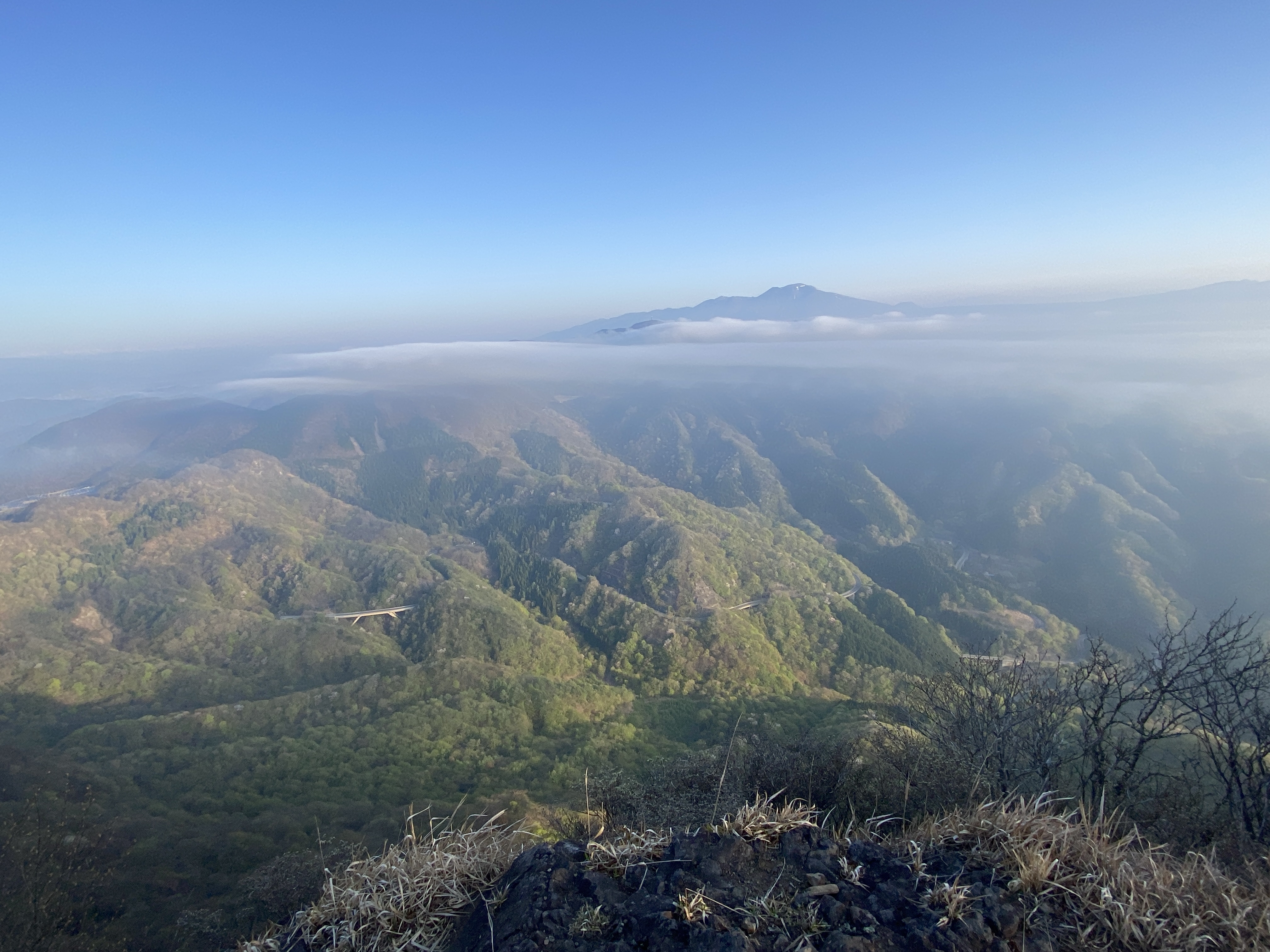
Nagaoka City in the foreground. The Sea of Japan behind it.


Hanatate Pass (花立峠)


There was a looooot of poop up there. Seriously, there were like 20 piles like this.
I saw one of those bear bells in the middle of one of the piles. I wonder what that could mean.


Mt. Onikura doesn't get much attention.
It's just as well. With a name means "Demon Warehouse" it probably needs an exorcism.


There were ropes on that side of Nokogiri. It was easier to get lost and the footing is not so great.


There were really a lot of people there. And they were all locals.
I was surprised when I showed up at this parking lot at 6:30 that I was not the first person there.
I really was not expecting to see this many people when I came off the trail.

The water hole is called something like "Fountain of Youth."

"The Fountain of Youth"
1 cup will give you 5 years
2 cups will give you 10 years
3 cups is the limit

On the way home, I dropped by the Aso Onsen.
It's a nice place.

I'd never seen this deal at an onsen. I don't know why not. It makes perfect sense.
It's a package deal for a a bath and lunch. (Not available during holidays, though.)

Well, I guess that's it for my report on Gohyaku.
I do still want to reminisce a bit. I had thought about putting up some of my favorite pictures to date but the task is too overwhelming.
It is kind of cool to look back. My footprint in Japan looks like this.
There are two dots on the northernmost island of Hokkaido.
Most of my footprints have been in the middle of Honshu.
A few hikes show up way down in the southwest on the island of Kyushu.

I used to live in western Tokyo and most of the miles I've put on my boots have been there.
I feel a kind of territorial need to not leave un-broken lines on my footprints so I can trace my footprints from Tokyo Station to Kanagawa, Mt. Fuji, Shizuoka, around Lake Hakone, around all the Fuji Five Lakes, to Saitama, Gunma and Nagano.

I moved to Nagano two years ago and have been trying to do the same type of thing here.
There are so many mountains.
They are always calling me.

Statistics are kind of fun. Now I have climbed 1,019 peaks. Many of them I have done more than once though. I think I have actually summited some mountain or other about 1,600 times.
I've climbed a mountain in 18 out of the 47 prefectures in Japan.
I've climbed the highest mountain in Japan, the highest one on Hokkaido, on Kyushu and of several prefectures. I've climbed the 4 highest mountains in the country.
Since 2018, my total elevation climbed is now 465,932 m (290 miles) and I have walked 6,572 km (4,083 miles).
I've burned 925,000 calories. (Why am I still carrying 20 extra pounds?)
As far as the mountains I have climbed the most, Mt. Kokuzo, a little hill near home is #1. I have climbed that 39 times. #2 is also in this area. Hiraofuji has been summited 12 times. (Two of those times I carried my bicycle to the top.) #3 is back in Tokyo. I showed Mt. Hinode some love 10 times. Makiyose, Otake, Aso and Mito were all climbed 8 times. Jinba, Iwatakeishi, Onuta and Akaru (in Nagano) came in at 7. Kumotori, Takanosu and a host of others at 6. Among a long list of 5-timers are Daibosatsurei and Nanatsuishi. There are too many on the lists of 2, 3 or 4 times to think of.
I'm glad that YAMAP keeps good records and I'm glad for this blog. I know not many people read this. (Actually, I doubt anyone has read this far on this post.) I have a bad memory and I want to be able to recall all these amazing experiences I've been allowed to have. Someday I won't be living here and/or I won't be able to do all this physical activity so I want to be able to savor it as much as possible.
Interested in Nagano's Mt. Gohyaku?
That's all for today.
Caveman out
Oh yeah, did you subscribe? Did you tell a friend?