What's up, peeps? It's been a dog's age. I have been saddled with social obligations for the last month and denied time in my mancave. I've been away from the mancave because I've had the opportunity to spend some quality time with friends nearly every weekend lately. What can I say? I'm a people person--kind of like Ron Swanson.
But seriously, it's been more than a month since I've been able to do anything blog-worthy. I've only been able to do a few short hikes on well-worn routes near home. The one longish excursion I did go on was on pavement. That was a 22 km powerwalk to Misasako (Lake Misasa) with the students at the high school I teach at. I had planned on just walking it but couldn't help myself and ran about half of it.
Running was dumb. To my consternation, the lack of trail time recently coupled with the fact that I was running on pavement in shoes I don't usually wear left me with a big broken blister that day. It's so disappointing. I haven't had a blister in probably 5 years. I like it that my feet usually are like leather and ready to go anywhere. It's been a week since that powerwalk and my blister still hasn't quite healed. I feel like a girly-man.
I am so glad I was able to get out this morning. Mrs. Caveman could certainly attest to the fact that I've been cranky lately and that I've been complaining about not being able to heed the mountains' call. Today I made my 3rd trip up Mt. Arafune. This was my first time to climb it from the Gunma side. Every time I drive down the road that passes this trailhead I have said to myself, "I really have to climb from there someday." Getting up and on the road before 4 enabled me to finally climb it and be back in time for work.
. . . about Mt. Arafune
Mt. Arafune is a mesa that lies on the line between Saku City, Nagano and Shimonita, Gunma. It's long, flat top makes it easily distinguishable for miles. It's on several "100 Mountain" lists and the list of 200 Mountains for all of Japan. It looks great as well as having great views.
The name, Arafune, has the word for boat in it. It is thought that it was named because it's long flat top resembles something like a boat. On one end of it is 艫岩 (Tomo iwa). "Tomo" means "stern" and "iwa" means "boulder."
I drove. There is parking for 3 cars. You can't get there by public transportation. Buses do run to Route 254, about an hour's walk from this trailhead.
Time estimates: YAMAP : 5:20 Yama to Kogen estimate: 4:45
Actual: Total Time: 3:15 Break time: :13Distance: 8.8 km
Elevation:Lowest: 583 m Highest: 1,422 m Total Ascent: 955 m Total Descent: 955 m
Technical considerations/difficulty:
This was a bit steep but there are no dangerous or particularly difficult spots. Most of this is below the tree line. It's steep, but not bad. Absolutely no ropes or chains. I seem to recall the trails from the Nagano side to be a bit spicier than this one.
Facilities:
There is an emergency hut by the Tomoiwa with a toilet. The toilet is out of order.
There is a porta poddy at the Aizawa Trailhead Parking Lot.
There was no internet connection on the lower portions of the trail. I could connect and communicate on top no problem.
Thoughts/observations/recommendations:
It's a nice trail and the view from Tomoiwa is really worth it.
Walk quietly and have your camera out and ready to take pictures of deer when walking on the long, flat part. Large groups of deer like to feed in that area.
Let's look at some pictures.
This was about 4:30 in the am, 25 minutes before sunrise. It was still quite dark but the flash lit up the sign.
5ish, just after sunrise.
One of many objet d'art I saw on the way.
Looking up at Tomoiwa from the trail. The picture doesn't pick it up but there were a few cherry trees on the side of the cliff in full bloom.
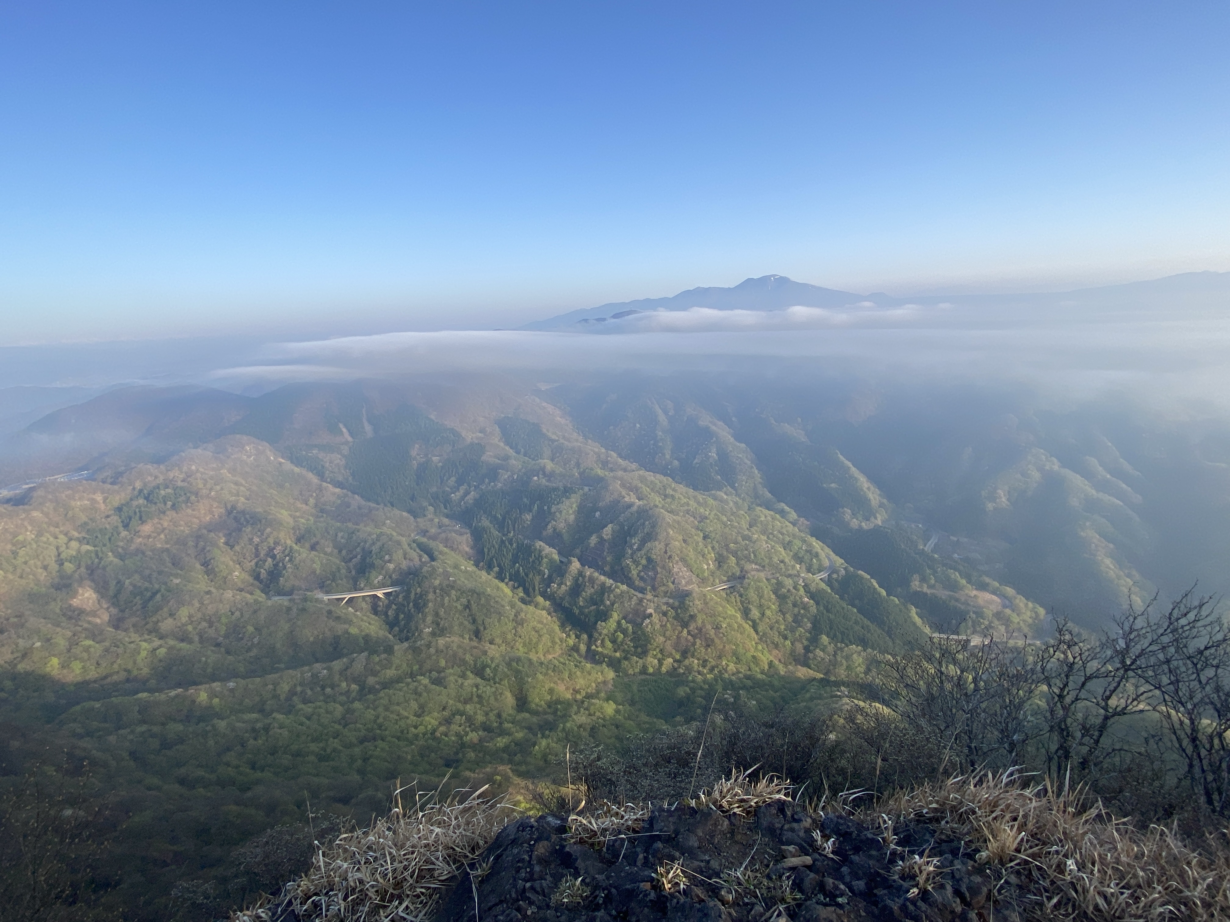
Taken at the Tomoiwa. Looking at Mt. Asama
Mt. Tateshina is the mountain in the distance just to the right of the cliff on the left.
Deer
There are a lot in this area usually. I saw 5 or 6 this morning--but had spooked them by stepping on a twig. I'm sure I chased many away.
The stretch from Tomoiwa to the peak of Mt. Arafune is quite flat.
The top of the mountain sports signs with two different names--and there is actually even one more name by which this mountain is called. The sign on the left reads "Mt. Kyozuka", the one on the right is "Mt. Arafune"
The drawing on the right is Crayon Shin-chan, a mischievous pre-schooler character in an anime of the same name. Sadly, the creator of Shin-chan, Yoshito Usui, met his demise on Arafune. It is believed to be an accidental death; that he fell when looking over the edge of a cliff. RIP. And thank you for the laughs.
Yatsugatake from the top of Arafune
Who makes this stuff?
Astute readers of the blog might identify a new set of wheels. My excursion to climb in Kyushu basically killed my beloved Suzy the Suzuki.
One more thing . . . have you clicked on the link to become a cave dweller? You'll get an email whenever I post. And I promise you, I don't do anything with your email address.
Holly the Honda could use some go-go juice to get me to more trailheads. She'd really appreciate it if you clicked the "Buy me a Coffee" link.
Minami Aiki is a village of about 900 souls in eastern Nagano. It's bordered by Gunma to the east and also Koumi, Kita Aiki, Kawakami and Minamimaki in Nagano. There is no highway or railway.
There is a great onsen.
Mt. Tengu is 1,882 meters high and sticks up in the air quite prominently.
Area:
Location:
Map: ***If you want a link to the latest Yama to Kogen map, comment and I'll get you a link. This link is to a printable map of the area.
(First-time) peaks # 1012~1014 (I'm pretending I haven't actually climbed #1,000 yet. I have a special peak in mind for that.)
Getting there/getting around:Car. This parking lot is just off Route 2, just before the point where it is closed off during the winter months.
The trail I took gets few hikers because of its character. There is a more popular trailhead further up the road at Magoshi Pass (馬越峠), accessible by taxi from Shinanokamikawa Station (about 20 minutes, about ¥4,000.) The place I parked is also accessible by taxi only in the summer months.
Elevation:Lowest: 1,359 m Highest: 1,882 m Total Ascent: 823 m Total Descent: 826 m
Technical considerations/difficulty:
There are lots of rocks you need to scramble over. Several spots have ropes that you really need to make use of.
In winter, special care is needed since you can't be sure what is under the snow cover. I used chain spikes for this hike. They were fine because there is only 10~15 cm of snow now. If it was a little deeper, I would suggest using wakan. Snowshoes would be too unwieldy. At one or two points I wished I had an ice axe--but not quite enough to justify carrying one around all day.
Facilities:
There is a public restroom and a camp store at the parking lot. There is nothing on the trail. Not waterholes, either.
Thoughts/observations/recommendations:
Tengu is a great mountain with a 360 degree panorama. I'm glad I could knock this and Mt. Otoko off. I have gone by them several times on my way to other mountains so it was nice to finally climb them. I would like to do them again on a really clear day, though!
I was happy to get out in the snow again this year. I was raised in a fairly snowy place and learned to get tired of winter. Now that I live in Nagano, though, I almost dread the coming of spring because it is so much fun to play in the snow.
OK, let me show you some pictures:
That's what it looks like from the parking lot.
Road closure from here
Lots of ropes . . .
The highest peak on the right side is Mt. Ogura. That is a great mountain.
I still remember the first time I saw it. I was climbing Akadake and said, "Wow, I want to climb that one next."
My next destinations after Mt. Tengu.
The top of Tengu
The top of Mt. Kakikoshi
The top of Mt. Otoko
Last stop was the Takiminoyu Onsen.
Nice place. It has several baths inside and outside as well as a mist sauna and a Finnish sauna.
One of the baths has a "pulse bath"--which means you get electric shocks at regular intervals.
And I thought I had missed the age of electro-shock therapy.