. . . about Shimonita
Shimonita is a small town of about 7,000 souls in Gunma. It is just to the east of Mt. Arafune near the prefectural boundary with Nagano. It's famous for konyaku (devil's tongue) and Welsh onions. These hills are not very high but they are rugged and offer the chance for hiking in solitude.
Location:
Map: ***If you want a link to the latest Yama to Kogen map, comment and I'll get you a link. This link is to a printable topo map Topo map centered on Mt. Akiya
Starting and stopping point: Side of the road by a fork in the trail
Peaks bagged: Akiya (秋葉山) 〜 Goshu (ゴシュウ山)
(First-time) peaks # 983
Getting there/getting around:
I drove. I hear it's about 20 minutes by taxi from Shimonita Station
Helpful Info
Weather Information: Nearby Kanadake's weather forecast
Time and distance
Total Time: 2:52 Break time: :27 Distance: 4 km
Elevation: Lowest: 440 m Highest: 940 m Total Ascent: 573 m Total Descent: 573 m
Technical considerations/difficulty:
A lot of this hike is slow and tedious. There are no improvements on the trail such as boardwalks or stairways. Much of it is steep with very loose walking surfaces. There are very few things to grab onto if you lose your footing so the chances of slipping and falling are always a concern. You really need a GPS and good sense to stay on track as the trail is difficult to discern. There are pink ribbons along the trail but sometimes they are difficult to spot and these hills get so little foot traffic that it is hard to tell the difference between human hiking trails and animal trails.
Facilities:
Nothing. The stream by the road is suitable for drinking. (At least I hope it is!)
Thoughts/observations/recommendations:
I wouldn't go out of my way to put this on my bucketlist if it wasn't so close to my home. It just met my needs for this particular day. I wanted a shorter hike because I had something to do in the afternoon.
Here are some stats and pictures.
The tunnel between Nagano and Gunma
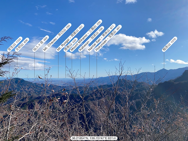
Looking east across Gunma to Tochigi
To the north is Myogi
Looking west to Arafune, the long flat mountain in the picture.
Arafune is flat because the andesite rock on the top is resistant to erosion.
Its name means a kind of ship. It's thought to resemble an aircraft carrier.
The highest point looks like the bow of a ship.
Myogi again.
It's just so cool looking.
There are some caves on the way to Akiya from the road.
That's all for today.
If you want to see more of this area, check out Kanadake and Yotsumata
Caveman out


No comments:
Post a Comment
Have a comment? Please, keep it clean.