Unusual, I know. Many people have mancaves for social purposes like watching sports or playing pool. I go to my mancave to get away from people.
Honestly, there are approximately 10 people on this planet that I would welcome into my mancave. (And there are approximately ten people on the planet that would want to remain friends after hiking with me once. I lose more friends on the trail than anywhere else. Nobody calls me up after our first hike and says, "Let's do that again.")
But I digress. As I was saying, some of the few people I'm willing to hike with came to Japan this week. We did some hiking in Yamanashi from Mt. Tenyo to Mt. Gongendake. It was a nice time to catch up with my relatives.
. . . about the southern end of Yatsugatake
Yatsugatake, as many know, is a range of mountains mostly in eastern Nagano that is about 30km long and runs from north to south. The southern end is higher and is characterized by more boulders whereas the northern end is a bit gentler and has more flora. Mt. Akadake, in the south, is the highest point in the Yatsugatake range at 2,899 meters. Most people access Akadake from the north, west or east and the mountains around Akadake on those sides are quite popular. For this hike, we went up to Gongendake, which is about 3 km to the south of Akadake in Yamanashi. This end of the Yatsugatake Range also is quite beautiful but is not as crowded because it is a long way to get to Akadake from here. Our hike started in Hokuto City, Yamanashi at the Mt. Tenyo Parking Lot.
Peaks bagged: Tenyo(天女山) ~ Maemitsugashira(前三ッ頭) ~ Mitsugashira(三ッ頭) ~ Gongen(権現岳)
(First-time) peaks # 223~226
Getting there/getting around:
I drove. The nearest bus stop is 2.2 km away at the Yatsugatake Kurabu Restaurant on the Kai Oizumi Line. The nearest train stations are Kai Oizumi or Kiyosato on the Koumi Line. I did see someone arrive by taxi when we were in the parking lot.
Elevation:Lowest: 1,522 m Highest: 2,715 m Total Ascent: 1,340 m Total Descent: 1,340 m
Technical considerations/difficulty:
This is pretty straightforward. A lot of it is below the treeline. It would be difficult to get lost. Just prior to the peak, there is one area with chains. Honestly, I was a bit disappointed in it. I had read a danger warning on YAMAP and was anticipating something spicier. 😂
Facilities:
There is a porta-potty next to the parking lot. There are no facilities whatsoever on the trail we used although there are several mountain huts not too far off.
Thoughts/observations/recommendations:
As always, I was happy to be in the woods. It was a cloudy day and we really got no views but the trees were beautiful and the Japanese Nightingales were singing beautifully.
We were a fairly large group of people and moved slowly. I think that getting to the kiretto within the same time frame would have been possible at my normal pace--that Akadake could be done in something like 10-11 hours, probably.
Here are some pics:
(This picture is not oriented correctly. It's been turned clockwise a bit.)
To get to Mt. Tenyo's peak, you walk downhill about 5 minutes from the parking lot. Easiest summit of my life.
The whole gang
Getting near the top:
The peak of Mt. Mitsugashira.
The name means "three" "heads."
Rhododendrons (shakunage 石楠花) and Siberian Dwarf Pine (haimatsu はいまつ)
She's a mountain goat.
The Caveman and John
⛓😁 Chains 😁⛓
Well, that's all for today. Don't forget to subscribe. Check out my youtube channel. If you value what I do, you can buy me a coffee. No pressure, though. If you want that nagging guilty feeling and don't mind losing a little sleep, who would I be to stop you?
The picture above is of Mt. Arafune. That is part of a collection of mountains on the border between Nagano and Gunma. Route 254 goes from Nagano into Gunma via the Uchiyama Tunnel which is under the Uchiyama Pass, which is between the spot where this picture was taken and Mt. Arafune. This side of the pass is an area with a lot of summer homes tucked deep in the woods. It's full of deer and other wildlife such as rabbits, foxes and even bears. There is a campground and panorama viewing spot (Arafune Panorama Campfield), a dairy farm with a restaurant as well as a petting zoo Suetoshi Farm nearby.
Area:
Location:
Map: ***If you want a link to the latest Yama to Kogen map, comment and I'll get you a link. This link is to a printable topo map of Mt. Monomi
Starting and stopping point: I started in the Nozawa section of Saku City on my bicycle for both trips.
Peaks bagged: Kumakura(熊倉峰) ~ Monomi(物見)
(First-time) peaks # ーーー
Getting there/getting around:Bicycle for both of these days. There is free parking at both trailheads.
Each of the two days was slightly different since the routes and destinations weren't the same. Each day was 10-12 miles uphill by bicycle to a trailhead where I hike another mile or so to a peak. The first day I climbed Kumakura. The second day I climbed Monomi. The first day took 2 hours 19 minutes. The second day took 3 hours 42 minutes.
Facilities:
The trailhead to Monomi is near the campground so I suppose there are toilets. There is a porta-potty at the trailhead to Kumakura. That trailhead also serves Mt. Arafune, too.
Thoughts/observations/recommendations:
I love where I live. I love where I work. I could do both of these excursions before work on weekdays!
The first pictures are from the bike ride to Kumakura. Unfortunately, it was cloudy and the views weren't great.
I was surprised to see there were already hikers heading up to Arafune.
The top of Kumakura
The next pictures are of the trip to Monomi.
Mt. Asama before sunrise
This is the giant cosmos field next to the campground. I was really surprised this am not to encounter any deer there. There are usually a lot.
That's Mt. Arafune
Imakura is where I was the week before.
Looking out toward Myogi
Well, that's all for today.
Make sure you share this with all your friends.
Here's another early morning hike I made on Arafune at the beginning of the month.
Although this mountain is over 3,000 meters, thanks to the highest bus stop in the country (at 2,700 meters), climbers can find this beautiful mountain easily accessible during the summer months.
Norikura is in the southern portion of the Northern Alps and borders Nagano and Gifu Prefectures. Due to the large amount of snow at the high elevation, you can ski there all year. That is, if you don't mind skiing up before you ski down. All of the ski slopes with lifts are down lower and are barren of snow during the summer.
Mt. Norikura (乗鞍岳 in kanji) is one of the 100 Mountains on Mr. Fukada's list and offers a great panorama. The view of Ontake is especially impressive.
Area:
Location:
Map: ***If you want a link to the latest Yama to Kogen map, comment and I'll get you a link. This link is to a printable topo map
Peaks bagged: Asahidake (朝日岳) ~ Kodama (蚕玉岳) ~ Kengamine/Norikura (剣ヶ峰/乗鞍岳)
(First-time) peaks # 1,020~1,022
100 Famous Mountain #49
Getting there/getting around:There is parking at the Sanbontaki Resthouse. There is also bus service to and from there.
The Japan Alps website has information for public transportation to the Norikura Tatamidaira Trailhead, which is quite close to the top. Contemplating the time, money, and aggravation of changing from train to bus to camel to the back of a sherpa just makes my head hurt.
I parked at the Sanbontaki Resthouse because that's as far as private vehicles are allowed. I could have taken a bus from there but I was happier to walk. For one thing, I go to the mountains to get away from people and schedules. For another, I'm a cheapskate. And lastly, I go to the mountains because I like to walk. Why pay someone for the privilege of doing less of what I enjoy?
FWIW, if I went there by public transportation, it would take over 7 hours. To get there via public transportation from Shinjuku would take just about the same time. I was able to drive there in 3. Gas and tolls were less than trains and buses would have been.
Elevation:Lowest: 1,755 m Highest: 3,026 Total Ascent: 1,476 m Total Descent: 1,476 m
Technical considerations/difficulty:
Hiking from where I started makes for a fairly long hike with a large change in elevation. That said, roughly the lower half of my hike was on pavement. Even after that, when I was walking on the trails, it was still a steady ascent with no boulder fields, no ropes, no chains, and no ladders to speak of.
Much of the hike is above the treeline so it would be very hard to get lost, I think. It was easy to see long distances because snow covered everything. When the snow is all gone, I'm no sure the effect on visibility. Even so, there is a bus road that winds high up into these mountains so that would make it hard to get lost.
There is a hiking trail on the lower half of my route but it is closed due to snow during winter.
Facilities:
There are porta-potties here and there. Near the top of Norikura, there is an emergency hut. There are lots of streams and rivers so water shouldn't be a problem.
This was a special mountain. They all are, but some days are better than others. I'm really happy with how the plan came together. I was able to play in the snow but, except for about 5 minutes on the top, spent the day just in my t-shirt. (I had pants on, too. Get your minds out of the gutter.) I felt so good and the conditions were so amenable that I was able to cover about 15 miles in a day and didn't feel like I broke a sweat.
I'm glad I remembered my sunscreen and sunglasses. It's very easy to forget these in winter. Snow can give you a worse burn than a day at the beach. Blinding light reflected off the sun is no fun, either.
I should have paid more attention to my feet. I went in three-season boots because I didn't anticipate much cold. It turned out to be fine, but my feet did get wet from walking in soft, slushy snow. If I broke a leg or something and had to spend the night on the mountain, I could have been in danger of frostbite with wet feet after the temps dropped. I think I will wear winter/water-proof boots next time in the snow. A spare pair of socks would be a good idea, too.
Speaking of wet feet, I am so glad I made the extra little trek to see the Sanbontaki (Three Falls)! That was cool! Indeed, my feet did get wet because I wanted to get some pictures that I wouldn't have been able to take without walking in the water.
Last thought: If you can get to a mountain like this on a weekday or in the off-season, I highly recommend it. Since it was a weekday and I stayed away from the bus crowd, I had the trail to myself almost all day. When I got to the onsen, there was only one other guy there. As I was leaving the onsen, the bus showed up and I scooted home.😉
Here are some pictures:
This is the starting point, the Sanbotaki Resthouse.
I started out with an eye to using a variation route that would begin above the ski trails. Above the lifts, though, the brush was very thick and the snow-covered streams made me re-think that plan. I decided to descend a bit and hike up the road instead.
I love running water. This is a great season for me.
The trail from the Sanbotaki is closed due to snow. I stayed on the pavement until getting past the Kuraigara Sanso.
After a few hours, I hit the Kuraigahara Sanso and then entered the trail just beyond it.
You can stay there, by the way. You can take a bus there, too.
This is the beginning of the trail. I encountered other people here. They were either putting on crampons or putting on their skis.
What a great morning it had been so far.
Behind me are the rest of the southern Kita Alps.
I didn't sink into the snow too often on this day but when I did, it was up to my thighs.
I couldn't understand all the people wearing goretex and balaclavas. I was quite warm enough in a t-shirt.
This torii is at the top.
The marker
These days I've been eating a lot of satsumaimo (sweet potato). Bake one of these suckers in tin foil for about an hour and you've got a great, sweet snack.
What do you think I brought my pillow for?
Watch the video!
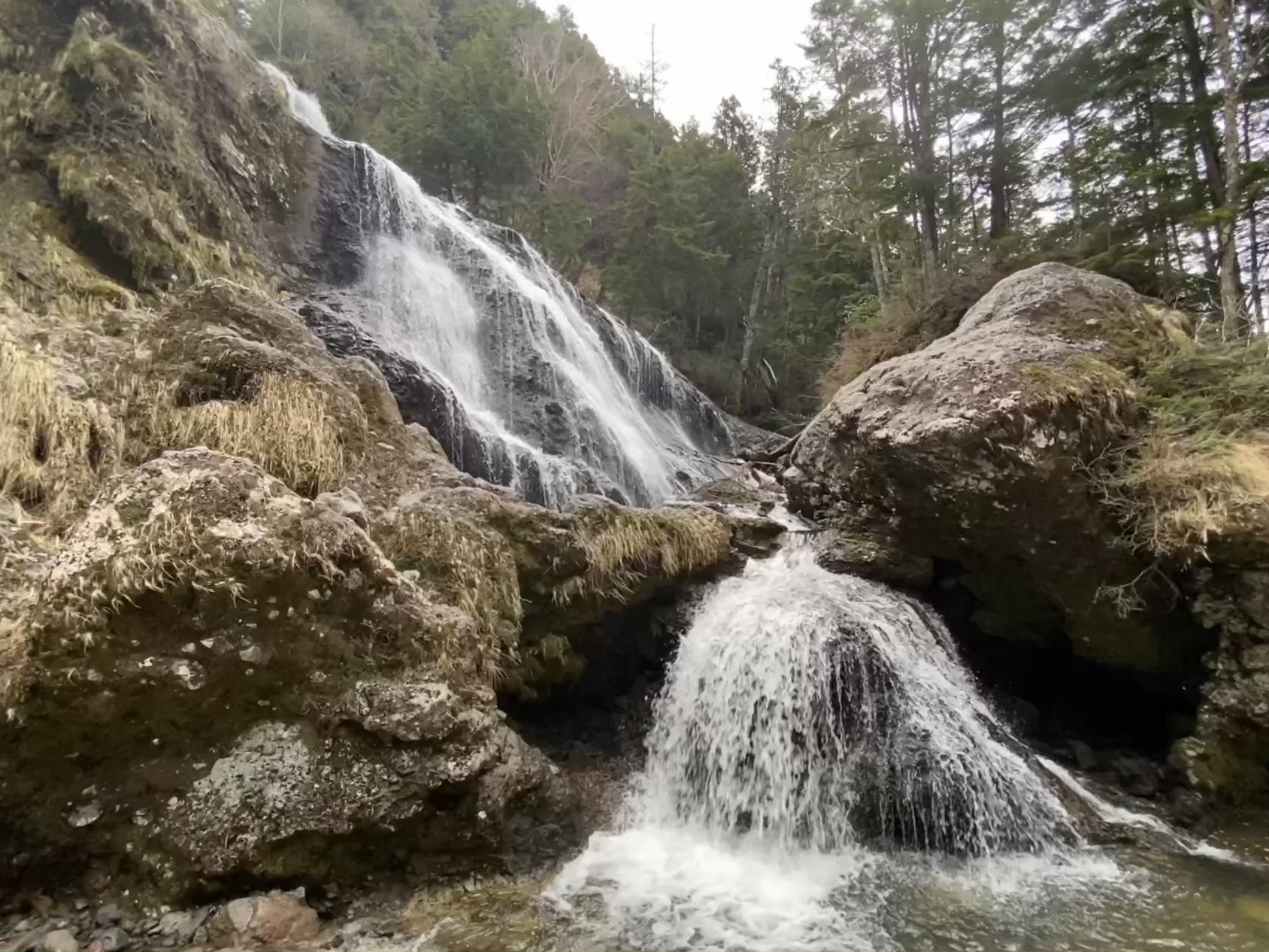
Not far from where I parked is the Sanbontaki Falls.
It is the confluence of three separate falls into one river.
They are VERY cool. I'm glad I made the extra trip. Don't miss them if you go to this area.
They were so cool, and I wanted to get some pictures so badly that I happily waded through the stream.
Well, that's it for today. Take care.
Don't forget to like, subscribe, tell your friends about me and buy me some coffee.
One of my favorite youtubers always says "Hit the like button. It's all I care about." I'd rather you hit the paypal button--but I'm a greedy SOB.